|
Fire Services In York Region
Fire services in the York Region of Canada are provided for and by each municipality. There are 35 fire stations across the region. Most services consist of full-time members, but some services have volunteer firefighters. The departments in south York Region deal mostly with residential and commercial incidents. The northern departments deal with rural, residential and agricultural fire needs. History Fire departments in York Region date back to the 19th century, and all were volunteer units. Later in the 20th century full-time fire departments were created. Some departments in the region still retain volunteer units. East Gwillimbury Fire was the last all-volunteer service in the region until 2008, when the first crew of career firefighters was hired. East Gwillimbury and Georgina still have some volunteer stations, but the Township of King is the only department which remains as an all-volunteer department, with a staff of 105 volunteers servicing King City, Nobelton and Schombe ... [...More Info...] [...Related Items...] OR: [Wikipedia] [Google] [Baidu] |
Regional Municipality Of York, Ontario
The Regional Municipality of York, also called York Region, is a regional municipality in Southern Ontario, Canada, between Lake Simcoe and Toronto. The region was established after the passing of then Bill 102, An Act to Establish The Regional Municipality of York, in 1970. It replaced the former York County in 1971, and is part of the Greater Toronto Area and the inner ring of the Golden Horseshoe. The regional government is headquartered in Newmarket. The 2021 census population was 1,173,334, with a growth rate of 5.7% from 2016. The Government of Ontario expects its population to surpass 1.5 million residents by 2031. The largest cities in York Region are Markham, Vaughan and Richmond Hill. History At a meeting in Richmond Hill on May 6, 1970, officials representing the municipalities of York County approved plans for the creation of a regional government entity to replace York County. The plan had been presented in 1969 by Darcy McKeough, the Ontario Minister of Mu ... [...More Info...] [...Related Items...] OR: [Wikipedia] [Google] [Baidu] |
King City, Ontario
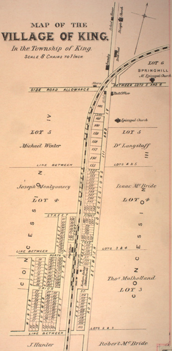
King City is an unincorporated Canadian community in the township of King, Ontario, located north of Toronto. It is the largest community in King township, with 2,730 dwellings and a population of 8,396 as of the 2021 Canadian census. History In 1836, a settlement styled ''Springhill'' was established in King. With the arrival of the Ontario, Simcoe and Huron railway in 1853, the settlement began to expand. In 1890, the reeve of King township (James Whiting Crossley) incorporated King City by merging the hamlets of Springhill, Kinghorn, Laskay, and Eversley. Geography King City is characterized by rolling hills and clustered temperate forests in the Eastern Great Lakes lowland forests ecoregion. Numerous kettle lakes and ponds dot the area. Creeks and streams from King City, the surrounding area, and as far west as Bolton and as far east as Stouffville are the origin for the East Humber River. Situated entirely on the southern slope of the central portion of the Oak Ridge ... [...More Info...] [...Related Items...] OR: [Wikipedia] [Google] [Baidu] |
Toronto/Buttonville Municipal Airport
Buttonville Municipal Airport or Toronto/Buttonville Municipal Airport is a medium-sized airport in the neighbourhood of Buttonville in Markham, Ontario, Canada, north of Toronto. It is operated by Torontair. Due to its proximity to Toronto's suburbs, there are several strict noise-reduction procedures for aircraft using the airport, which is open and staffed 24 hours a day, 365 days a year. In 2014, Buttonville was Canada's 20th busiest airport by aircraft movements. There is also a weather station located at the airport. The airport is classified as an airport of entry by Nav Canada and is serviced by the Canada Border Services Agency (CBSA) on a call-out basis from Oshawa Executive Airport during weekdays and Billy Bishop Toronto City Airport during weekends. CBSA officers at this airport handle general aviation aircraft only, with no more than 15 passengers. History Fred F. Gillies was the operator of Buttonville Airport and Gillies Flying Service starting in 1953 until ... [...More Info...] [...Related Items...] OR: [Wikipedia] [Google] [Baidu] |
Markham, Ontario
Markham () is a city in the Regional Municipality of York, Ontario, Canada. It is approximately northeast of Downtown Toronto. In the 2021 Census, Markham had a population of 338,503, which ranked it the largest in York Region, fourth largest in the Greater Toronto Area (GTA), and 16th largest in Canada. The city gained its name from the first Lieutenant-Governor of Upper Canada, John Graves Simcoe (in office 1791–1796), who named the area after his friend, William Markham, the Archbishop of York from 1776 to 1807. Indigenous people lived in the area of present-day Markham for thousands of years before Europeans arrived in the area. The first European settlement in Markham occurred when William Berczy, a German artist and developer, led a group of approximately sixty-four German families to North America. While they planned to settle in New York, disputes over finances and land tenure led Berczy to negotiate with Simcoe for in what would later become Markham Township ... [...More Info...] [...Related Items...] OR: [Wikipedia] [Google] [Baidu] |
Richmond Hill, Ontario
Richmond Hill ( 2021 population: 202,022) is a city in south-central York Region, Ontario, Canada. Part of the Greater Toronto Area, it is the York Region's third most populous municipality and the 27th most populous municipality in Canada. Richmond Hill is situated between the cities of Markham and Vaughan, north of Thornhill, and south of Aurora. Richmond Hill has seen significant population growth since the 1990s. It became a city in 2019 after being a town since 1957. The city is home to the David Dunlap Observatory telescope, the largest telescope in Canada. History The village of Richmond Hill was incorporated by a bylaw of the York County Council on June 18, 1872, coming into effect January 1, 1873.; see also Archaeological Services, Inc.,Town of Richmond Hill Official Plan: Archaeological and First Nations Policy Study," October 2009;The Stage 4 Salvage Excavation of the Orion Site," Dec. 2008. In September 1956, the Ontario Municipal Board approved its elevation ... [...More Info...] [...Related Items...] OR: [Wikipedia] [Google] [Baidu] |
Woodbridge, Ontario
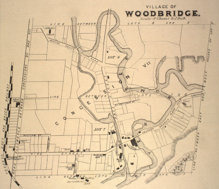
Woodbridge is a very large suburban community in Vaughan, Ontario, Canada, along the city's border with Toronto. It occupies the city's entire southwest quadrant, west of Highway 400, east of Highway 50, north of Steeles Avenue, and generally south of Major Mackenzie Drive. It was once an independent town before being amalgamated with nearby communities to form the city in 1971. Its traditional downtown core is the Woodbridge Avenue stretch between Islington Avenue and Kipling Avenue north of Highway 7. History The community had its origins with the British Crown granting the west half of lots six and seven, concession 7 of Vaughan Township to Jacob Philips and Hugh Cameron in 1802. Woodbridge had its beginnings in what is today Pine Grove. During the early half the 19th century, a school was built on Vaughan's eighth concession; and a flour mill and store flourished. A scattering of houses arose around Smith's mill (later Hayhoe Mills), Smith's mill later became known a ... [...More Info...] [...Related Items...] OR: [Wikipedia] [Google] [Baidu] |
Yonge Street
Yonge Street (; pronounced "young") is a major arterial route in the Canadian province of Ontario connecting the shores of Lake Ontario in Toronto to Lake Simcoe, a gateway to the Upper Great Lakes. Once the southernmost leg of provincial Highway 11, linking the provincial capital with northern Ontario, Yonge Street has been referred to as "Main Street Ontario". Until 1999, the ''Guinness Book of World Records'' repeated the popular misconception that Yonge Street was long, making it the longest street in the world; this was due to a conflation of Yonge Street with the rest of Ontario's Highway 11. Yonge Street (including the Bradford-to-Barrie extension) is only long. Due to provincial downloading in the 1990s, no section of Yonge Street is marked as a provincial highway. The construction of Yonge Street is designated as an Event of National Historic Significance in Canada. Yonge Street was integral to the original planning and settlement of western Upper Canada in the ... [...More Info...] [...Related Items...] OR: [Wikipedia] [Google] [Baidu] |
Thornhill, Ontario
Thornhill is a suburban district in the Regional Municipality of York in Ontario, Canada, split between the City of Vaughan (its western portion) and the City of Markham (its eastern portion), with Yonge Street forming the municipal boundary. Thornhill is situated along the northern border of Toronto, centred on Yonge, and is also immediately south of the City of Richmond Hill. Once a police village, Thornhill is still a postal designation. As of 2016, its total population, including both its Vaughan and Markham sections, was 112,719. History Early history Thornhill was founded in 1794. For a fuller account of Thornhill's early history, see Isabel Champion, ed., Markham: 1793–1900' (Markham, ON: Markham Historical Society, 1979), 297–301; 70f., 97f., 140f., 170, 335. The original boundaries were the northern bounds of the Ladies Golf Club on the east side of Yonge and further north on the west side of Yonge; southern end between John Street and Arnold Avenue/Elgin Street ... [...More Info...] [...Related Items...] OR: [Wikipedia] [Google] [Baidu] |
Concord, Ontario
Concord is a suburban industrial district in the City of Vaughan in York Region, located north of Toronto, Ontario, Canada. According to the 2001 Census, Concord has 8,255 residents. It is accessed by two provincial highways: Highway 407 and Highway 400. Concord's approximate boundaries are Steeles Avenue to the south, Highway 400 to the west, Dufferin Street to the east, and Rutherford Road to the north, though it includes the Carrville neighbourhood east to Bathurst Street between Rutherford and Highway 7. The area along Highway 7, from Highway 400 to just east of Jane Street, though still often considered by many to be part of Concord, is now officially a new district, the Vaughan Metropolitan Centre, which is Vaughan's planned urban core. History Concord became a postal village in 1854 when John Duncan became postmaster at the northwest corner of Dufferin Street and Centre Street. The area's name is likely linked to Hiram White (1788-1859) who came to Vaughan from C ... [...More Info...] [...Related Items...] OR: [Wikipedia] [Google] [Baidu] |
Kleinburg, Ontario
Kleinburg is an unincorporated village in the city of Vaughan, Ontario, Canada. It is home to the McMichael Canadian Art Collection, an art gallery with a focus on the Group of Seven, and the Kortright Centre for Conservation. In 2001, the village and its surrounding communities had a population of 4,595; the village itself has 282 dwellings, with a population of 952. Kleinburg comprises a narrow section of hilly landscape situated between two branches of the Humber River. The historic village is bounded by Highway 27 on the west and Stegman’s Mill Road to the east. Kleinburg has subsumed the nearby hamlet of Nashville, but it has not itself been fully subsumed into the main urban area of Vaughan. Geography The village is located between two branches of the Humber River, and features dense forests throughout its 1.05 km² of land area. Its northern and western peripheries are primarily agricultural. History The community was founded in 1848 by John Nicholas Kline (182 ... [...More Info...] [...Related Items...] OR: [Wikipedia] [Google] [Baidu] |
Maple, Ontario
Maple is a neighbourhood in Vaughan, York Region, Ontario, Canada. It is located northwest of Toronto. Maple was founded as the village of Maple, located at the intersection of Major Mackenzie Drive and Keele Street. Geography Maple is located in the Golden Horseshoe of Southern Ontario. To the northeast of is the Oak Ridges Moraine, which supplies a lot of water to the Greater Toronto Area. The west branch of the Don River rises to the northwest and flows 1 km west of Maple. Several creeks are to the east and the Black Creek begins slightly west of Vellore. Humber River flows in the west, the Don River flows to the northern and the eastern part. York University Keele Campus lies to the south of Steeles Avenue, within the city of Toronto. Climate Maple has a continental climate moderated by the Great Lakes and influenced by warm, moist air masses from the south, and cold, dry air from the north. Transportation Maple's central cross streets are Major Mackenzie Driv ... [...More Info...] [...Related Items...] OR: [Wikipedia] [Google] [Baidu] |
Vaughan
Vaughan () (2021 population 323,103) is a city in Ontario, Canada. It is located in the Regional Municipality of York, just north of Toronto. Vaughan was the fastest-growing municipality in Canada between 1996 and 2006 with its population increasing by 80.2% during this time period and having nearly doubled in population since 1991. It is the fifth-largest city in the Greater Toronto Area, and the 17th-largest city in Canada. Toponymy The township was named after Benjamin Vaughan, a British commissioner who signed a peace treaty with the United States in 1783. History In the late pre-contact period, the Huron-Wendat people populated what is today Vaughan. The Skandatut ancestral Wendat village overlooked the east branch of the Humber River (Pine Valley Drive) and was once home to approximately 2,000 Huron in the sixteenth century. The site is close to a Huron ossuary (mass grave) uncovered in Kleinburg in 1970, and one kilometre north of the Seed-Barker Huron site. The fir ... [...More Info...] [...Related Items...] OR: [Wikipedia] [Google] [Baidu] |


.jpg)


