|
Fajã De Água
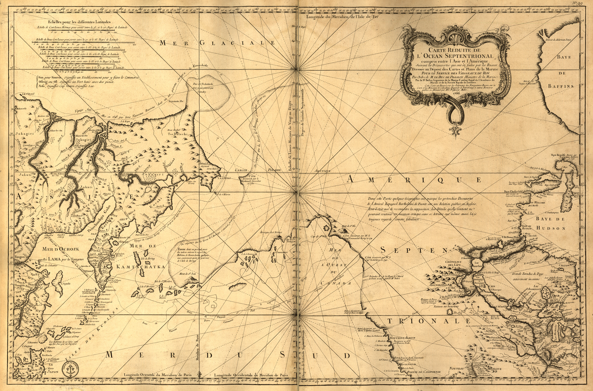
Fajã de Agua is a village on the northwestern coast of the island of Brava, Cape Verde. It is 4 km west of the island capital Nova Sintra. Fishing and agriculture (maize, beans, bananas and papayas) are the most important sources of income. History The point was mentioned as ''Faciend de Agoa'' in the 1747 map by Jacques-Nicolas Bellin. In the 18th and 19th century, whaling was an important source of income for Brava. Many whaling ships from America landed in Fajã de Água. Fajã de Água used to be the most important harbour of Brava until 1843 when the present harbour of Furna was founded.Lipps, Susanne: ''Kapverdische Inseln'', p.275-276. Ostfildern 2009 A small airport named Esperadinha with a paved runway was inaugurated in Fajã de Água in 1992. It connected Brava with the nearby islands of Fogo and Santiago, but was closed in 2004 because of frequent strong winds which make landing impossible. Sights There is a beautiful walking track to the pilgrimage chur ... [...More Info...] [...Related Items...] OR: [Wikipedia] [Google] [Baidu] |
Brava, Cape Verde
Brava (Portuguese for "wild" or "brave") is an island in Cape Verde, in the Sotavento group. At , it is the smallest inhabited island of the Cape Verde archipelago, but at the same time the greenest. First settled in the early 16th century, its population grew after Mount Fogo on neighbouring Fogo erupted in 1680. For more than a century, its main industry was whaling, but the island economy is now primarily agricultural. History Brava was discovered in 1462 by the Portuguese explorer Diogo Afonso.Valor simbólico do centro histórico da Praia Lourenço Conceição Gomes, Universidade Portucalense, 2008, p. 97 There is no evidence of human presence on the Cape Verde islands before the arrival of the Portuguese. Around 1620 the population of Brava started with the arrival of settlers from |
Cape Verde
, national_anthem = () , official_languages = Portuguese , national_languages = Cape Verdean Creole , capital = Praia , coordinates = , largest_city = capital , demonym = Cape Verdean or Cabo Verdean , ethnic_groups_year = 2017 , government_type = Unitary semi-presidential republic , leader_title1 = President , leader_name1 = José Maria Neves , leader_title2 = Prime Minister , leader_name2 = Ulisses Correia e Silva , legislature = National Assembly , area_rank = 166th , area_km2 = 4033 , area_sq_mi = 1,557 , percent_water = negligible , population_census = 561,901 , population_census_rank = 172nd , population_census_year = 2021 , population_density_km2 = 123.7 , population_density_sq_mi = 325.0 , population_density_rank = 89th , GDP_PPP ... [...More Info...] [...Related Items...] OR: [Wikipedia] [Google] [Baidu] |
Nova Sintra
Nova Sintra is a cityCabo Verde, Statistical Yearbook 2015 , Instituto Nacional de Estatística, p. 32-33 in the central part of the island of in southwestern . It serves as the seat of the Brava Municipality. The settlement is named after |
Jacques-Nicolas Bellin
Jacques Nicolas Bellin (1703 – 21 March 1772) was a French hydrographer, geographer, and member of the French intellectual group called the philosophes. Bellin was born in Paris. He was hydrographer of France's hydrographic office, member of the ''Académie de Marine'' and of the Royal Society of London. Over a 50-year career, he produced many maps of particular interest to the ''Ministère de la Marine''. His maps of Canada and of French territories in North America (New France, Acadia, Louisiana) are particularly valuable. He died at Versailles. First ''Ingenieur de la Marine'' In 1721, at age 18, he was appointed hydrographer (chief cartographer) to the French Navy. In August 1741, he became the first ''Ingénieur de la Marine of the Dépot des cartes et plans de la Marine'' (the French Hydrographical Office) and was named Official Hydrographer of the French King. Prodigious work, high standard of excellence During his reign the Depot published a prodigious number of cha ... [...More Info...] [...Related Items...] OR: [Wikipedia] [Google] [Baidu] |
Furna (Brava)
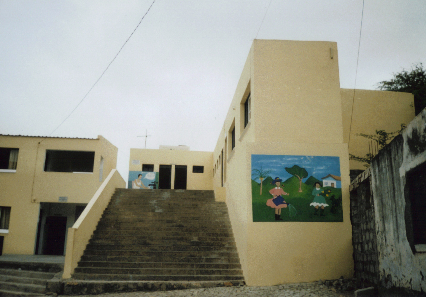
Furna is a seaside community in the northeastern part of the island of Brava, Cape Verde. It lies 2.5 km northeast of the island capital of Nova Sintra. At the 2010 census its population was 612. About the village The settlement was mentioned as ''Fuurno'' in the 1747 map by Jacques-Nicolas Bellin. Furna became the most important harbour of Brava in 1843. In 1982, many boats and some houses of Furna were destroyed by waves reaching a height of up to 10 meters which were caused by the tropical storm ''Beryl''. The harbour was improved in 2000. There are ferry connections to São Filipe in Fogo and Praia in Santiago. Brava has a chapel known as Nossa Senhora de Boa Viagem. The new yellow school near the small church in the South of the village, which was paid by the government of Belgium, has large wall paintings motivating the children to save as much water as possible and to help keeping the island green. Less than a kilometer northeast of Furna is the headland Pont ... [...More Info...] [...Related Items...] OR: [Wikipedia] [Google] [Baidu] |
Esperadinha Airport
Esperadinha Airport was a public use airport located near the hamlet of Esperadinha, northwestern Brava, Cape Verde. It opened in 1992 and operated until 2004, when it was closed due to persistent dangerous high winds. See also *List of airports in Cape Verde This is a list of airports in Cape Verde, which have been historically an important infrastructural need for the economy and development of the country, since being an archipelago makes it impossible to have terrestrial links between the main citi ... References External links Airport record for Esperadinha Airportat Landings.com Airports in Cape Verde Brava, Cape Verde Defunct airports {{CapeVerde-airport-stub ... [...More Info...] [...Related Items...] OR: [Wikipedia] [Google] [Baidu] |
Fogo, Cape Verde
Fogo (Portuguese for "fire") is an island in the Sotavento group of Cape Verde. Its population is 35,837 (2015),Cabo Verde, Statistical Yearbook 2015 Instituto Nacional de Estatística with an area of 476 km2. It reaches the highest altitude of all the islands in Cape Verde, rising to at the summit of its active volcano, |
Santiago, Cape Verde
Santiago (Portuguese for “ Saint James”) is the largest island of Cape Verde, its most important agricultural centre and home to half the nation's population. Part of the Sotavento Islands, it lies between the islands of Maio ( to the east) and Fogo ( to the west). It was the first of the islands to be settled: the town of Ribeira Grande (now Cidade Velha and a UNESCO World Heritage Site) was founded in 1462. Santiago is home to the nation's capital city of Praia. History The eastern side of the nearby island of Fogo collapsed into the ocean 73,000 years ago, creating a tsunami 170 meters high which struck Santiago. In 1460, António de Noli became the first to visit the island. Da Noli settled at ''Ribeira Grande'' (now Cidade Velha) with his family members and Portuguese from Algarve and Alentejo in 1462.Valor simbóli ... [...More Info...] [...Related Items...] OR: [Wikipedia] [Google] [Baidu] |
Nossa Senhora Do Monte, Cape Verde
Nossa Senhora do Monte is a townCabo Verde, Statistical Yearbook 2015 , Instituto Nacional de Estatística, p. 32-33 located in the heart of the island of , . It is the seat of the parish of Nossa Senhora do Monte. Its elevation is 650 m, and its pop ... [...More Info...] [...Related Items...] OR: [Wikipedia] [Google] [Baidu] |


