|
Faddiley
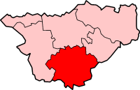
Faddiley is a small village (at SJ 590 530) and civil parish in the unitary authority of Cheshire East and the ceremonial county of Cheshire, England. The village is located 4 miles to the west of Nantwich. The parish also includes the small settlements of Larden Green and Woodhey or Woodhey Green, with a total population of just over 150,Genuki: Faddiley (accessed 14 August 2007) measured at 163 during the 2011 Census. Nearby villages include , , |
Listed Buildings In Faddiley
Faddiley is a civil parish in Cheshire East, England. It contains twelve buildings that are recorded in the National Heritage List for England as designated listed buildings. Of these, one is listed at Grade I, the highest grade, one is listed at Grade II*, the middle grade, and the others are at Grade II. Apart from small settlements, the parish is rural, and most of the listed buildings are houses, cottages, and farm buildings. The other listed buildings are the remains of an ancient cross, a private chapel and its enclosure, and a public house. Key Buildings See also *Listed buildings in Baddiley * Listed buildings in Brindley *Listed buildings in Burland * Listed buildings in Cholmondeley *Listed buildings in Chorley * Listed buildings in Ridley *Listed buildings in Spurstow Spurstow is a Civil parishes in England, civil parish in Cheshire East, England. It contains 17 buildings that are recorded in the National Heritage List for England as designa ... [...More Info...] [...Related Items...] OR: [Wikipedia] [Google] [Baidu] |
Woodhey Chapel, Faddiley
Woodhey Chapel is a Grade I listed private chapel off Woodhey Lane near Faddiley, Cheshire, England. The listing describes the building as 'A handsome and intact example of a chapel from a period when few were built'. The chapel, which is now disused, stands in fields near the site of the demolished Woodhey Hall. Its west end is connected to buildings of the former hall by a causeway which is raised by about . History In a will dated 1537 is a possible reference to a domestic chapel at Woodhey. The present chapel dates from about 1700 and was built by Lady Wilbraham, the widow of the Thomas Wilbraham, the last baronet of Woodhey. The chapel was restored in 1926. Architecture Exterior The chapel is constructed in red brick with stone trimmings and has a slate roof. It was built against an early 17th-century stone loggia which forms its west face. The loggia provided an entrance for the Wilbraham family to the west gallery of the chapel. It consists of an arcade of three ... [...More Info...] [...Related Items...] OR: [Wikipedia] [Google] [Baidu] |
Brindley
Brindley is a village (at ) and civil parish in Cheshire, England. The village lies 3¾ miles to the west of Nantwich. The parish also includes the settlements of Brindley Lea, Ryders Bank and part of Radmore Green,Genuki: Brindley (accessed 29 May 2008) with a total population of about 150. Nearby villages include Barbridge, , Haughton and . History The name Brindle ...[...More Info...] [...Related Items...] OR: [Wikipedia] [Google] [Baidu] |
Woodhey Cross
Woodhey Cross is a late medieval stone cross, probably dating from the early 16th century, located near Faddiley in Cheshire, England.Images of England: Woodhey Cross, Woodhey Lane (accessed 14 February 2008) (accessed 14 February 2008) The structure is grade II* listed and is also a . [...More Info...] [...Related Items...] OR: [Wikipedia] [Google] [Baidu] |
Civil Parishes In Cheshire
A civil parish is a country subdivision, forming the lowest unit of local government in England. There are 333 civil parishes in the ceremonial county of Cheshire, most of the county being parished. Cheshire East unitary authority is entirely parished. At the 2001 census, there were 565,259 people living in 332 parishes, accounting for 57.5 per cent of the county's population. History Parishes arose from Church of England divisions, and were originally purely ecclesiastical divisions. Over time they acquired civil administration powers.Angus Winchester, 2000, ''Discovering Parish Boundaries''. Shire Publications. Princes Risborough, 96 pages The Highways Act 1555 made parishes responsible for the upkeep of roads. Every adult inhabitant of the parish was obliged to work four days a year on the roads, providing their own tools, carts and horses; the work was overseen by an unpaid local appointee, the ''Surveyor of Highways''. The poor were looked after by the monasteries, until ... [...More Info...] [...Related Items...] OR: [Wikipedia] [Google] [Baidu] |
Woodhey Chapel Faddiley
Woodhey or Woodheys may refer to: *Woodhey, an area of Bebington, Merseyside, *Woodhey or Woodhey Green, a small settlement in the Faddiley civil parish of Cheshire, *Woodhey Chapel, Faddiley, a private chapel in Cheshire, *Woodhey Cross, an ancient stone cross in Cheshire, *Woodhey High School, a secondary school in Ramsbottom, in the Metropolitan Borough of Bury, Greater Manchester. *Woodheys Primary School, a primary school in Sale, Trafford, Greater Manchester Greater Manchester is a metropolitan county and combined authority, combined authority area in North West England, with a population of 2.8 million; comprising ten metropolitan boroughs: City of Manchester, Manchester, City of Salford, Salford ... * Woodheys Park, a park next to the Woodheys Estate in Sale Greater Manchester {{disambiguation ... [...More Info...] [...Related Items...] OR: [Wikipedia] [Google] [Baidu] |
Chorley, Crewe And Nantwich
Chorley is a hamlet (at ) and civil parish in the unitary authority of Cheshire East and the ceremonial county of Cheshire, England. The hamlet lies 5 miles to the west of Nantwich and 6 miles to the north east of Malpas. The total population is a little over a hundred people. Nearby villages include Faddiley, Norbury, Ravensmoor and Wrenbury. It should not be confused with the civil parish of Chorley near the town of Alderley Edge, also in Cheshire East. Governance Chorley is administered jointly with the adjacent parish of Cholmondeley by Cholmondeley & Chorley Parish Council. From 1974 the civil parish was served by Crewe and Nantwich Borough Council, which was succeeded on 1 April 2009 by the unitary authority of Cheshire East. Chorley falls in the parliamentary constituency of Eddisbury, which has been represented by Edward Timpson since 2019, after being represented by Stephen O'Brien (1999–2015) and Antoinette Sandbach (2015–19). Geography and transport The River W ... [...More Info...] [...Related Items...] OR: [Wikipedia] [Google] [Baidu] |
Crewe And Nantwich
Crewe and Nantwich was, from 1974 to 2009, a Non-metropolitan district, local government district with Borough status in the United Kingdom, borough status in Cheshire, England. It had a population (2001 census) of 111,007. It contained 69 civil parishes and one unparished area: the town of Crewe. It now forms part of the Unitary authorities of England, unitary authority of Cheshire East. History The Borough of Crewe and Nantwich was created on 1 April 1974 under the Local Government Act 1972 by the merger of the municipal borough, borough of Crewe (an industrial town), the Urban district (Great Britain and Ireland), urban district of Nantwich (a smaller market town), and Nantwich Rural District. The new district was proposed to be called just "Crewe", but the shadow authority elected in 1973 to oversee the transition to the new system successfully petitioned the government to change the name to "Crewe and Nantwich" before the district came into being. The new district was awar ... [...More Info...] [...Related Items...] OR: [Wikipedia] [Google] [Baidu] |
Cheshire East
Cheshire East is a unitary authority area with Borough status in the United Kingdom, borough status in the ceremonial county of Cheshire, England. The local authority is Cheshire East Council. Towns within the area include Crewe, Macclesfield, Congleton, Sandbach, Wilmslow, Handforth, Knutsford, Poynton, Bollington, Alsager and Nantwich. The council is based in the town of Sandbach. History The borough council was established in April 2009 as part of the 2009 structural changes to local government in England, by virtue of an order under the Local Government and Public Involvement in Health Act 2007. It is an amalgamation of the former boroughs of Macclesfield (borough), Macclesfield, Congleton (borough), Congleton and Crewe and Nantwich, and includes the functions of the former Cheshire County Council. The residual part of the disaggregated former County Council, together with the other three former Cheshire borough councils (Chester City, Ellesmere Port & Neston and Vale Royal) ... [...More Info...] [...Related Items...] OR: [Wikipedia] [Google] [Baidu] |
Burland
Burland is a village and civil parish in the unitary authority of Cheshire East and the ceremonial county of Cheshire, England, about 2½ miles west of Nantwich. The civil parish also includes the small settlements of Burland Lower Green, Burland Upper Green, Hollin Green and Stoneley Green, as well as parts of Gradeley Green and Swanley. The eastern part of the village of Ravensmoor also falls within the civil parish (also in the parish of Baddiley). According to the 2001 census the civil parish had a total population of 582, decreasing slightly to 580 at the 2011 Census. History The civil parish formerly had populations of 371 (1801), 627 (1851), 581 (1901) and 546 (1951). Governance Burland is administered by Burland Parish Council. The council consists of nine councillors, who meet monthly. In 2011 the Parish Council launched their own website. From 1974 the civil parish was served by Crewe and Nantwich Borough Council, which was succeeded on 1 April 2009 by the unitary a ... [...More Info...] [...Related Items...] OR: [Wikipedia] [Google] [Baidu] |
Ravensmoor
Ravensmoor is a village in the unitary authority of Cheshire East and the ceremonial county of Cheshire, England, located at . It is split between the civil parishes of Baddiley and Burland. It lies at an elevation of 65 m, around 2¼ miles south west of Nantwich and 6 miles south west of Crewe. The village centres on the crossroads of Baddiley Lane, Marsh Lane, Swanley Lane and Sound Lane, with a small village green adjacent. Much of the village dates from the second half of the 20th century. The village lies within a fork of the Shropshire Union Canal south of the Hurleston Hurleston is a civil parish in the unitary authority of Cheshire East and the ceremonial county of Cheshire, England, which lies to the north west of Nantwich. The parish is predominantly rural with scattered farms and buildings and no settleme ... Junction; the Llangollen branch runs ⅔ miles to the west and the main line of the canal runs just over a mile to the east. Ravensmoor Brook runs to th ... [...More Info...] [...Related Items...] OR: [Wikipedia] [Google] [Baidu] |
Haughton, Cheshire
Haughton (or Haughton Moss) is a village and civil parish which lies northwest of Nantwich in the unitary authority of Cheshire East and the ceremonial county of Cheshire, England. According to the 2001 Census, its population was 223, reducing to 204 at the 2011 Census, and has four fully active farms. Landmarks The Nags Head public house, a half-timbered building dating back to 1629, is situated in the village. It closed at the end of 2019. A war memorial mounted on a brick plinth on Long Lane was originally from neighbouring Radmore Green chapel. It was rescued by local residents Derek Rogers and Tom Dawson when the chapel was converted to a dwelling. It is dedicated to those associated with the chapel and the village, who fought in the First World War. Every year, Haughton Hall gardens are opened to the public, featuring a medium-sized garden; filled with rhododendrons, azaleas, shrubs, a rock garden, a lake with a temple, a waterfall and a collection of ornamental trees. ... [...More Info...] [...Related Items...] OR: [Wikipedia] [Google] [Baidu] |


