|
FRD-10
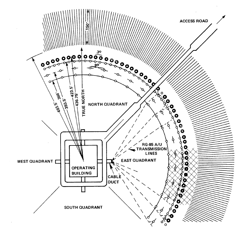
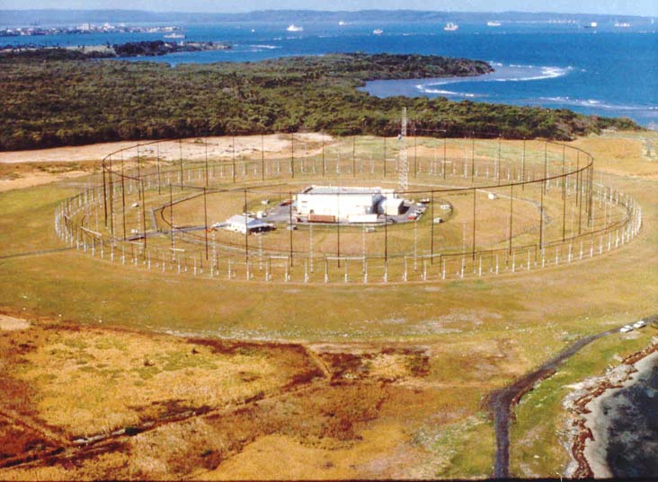
The AN/FRD-10 Circularly Disposed Antenna Array (CDAA) is a United States Navy circular "Wullenweber" antenna array, built at a number of locations during the cold war for high frequency radio direction finding (HF/DF) and signals intelligence. In the Joint Electronics Type Designation System, FRD stands for ''fixed ground, radio, direction'' finding. 14 sites were originally constructed as a part of the "Classic Bullseye" program. Two AN/FRD-10 systems were later installed in Canada. AN/FRD-10 systems were originally constructed in the early 1960s, but after the dissolution of the Soviet Union, the systems began to be shut down and demolished. The Naval Security Group operated and maintained the U.S. Navy AN/FRD-10 systems. The system had several nicknames including ''Fred-10'' and ''Elephant'' or ''Dinosaur cages''. As of 2015, none of the US Navy AN/FRD-10 sites are extant, but the two Canadian sites remain in service. The AN/FLR-9 was a system with a similar design and functi ... [...More Info...] [...Related Items...] OR: [Wikipedia] [Google] [Baidu] |
Wullenweber
The Wullenweber (the original name introduced by Dr. Hans Rindfleisch was Wullenwever) is a type of Circularly Disposed Antenna Array (CDAA) sometimes referred to as a Circularly Disposed Dipole Array (CDDA). It is a large circular antenna array used for radio direction finding. It was used by the military to triangulate radio signals for radio navigation, intelligence gathering and search and rescue. Because its huge circular reflecting screen looks like a circular fence, the antenna has been colloquially referred to as the ''elephant cage.'' The term ''wullenwever'' was the World War II German cover term used to identify their secret CDAA research and development program; its name is unrelated to any person involved in the program. History Origin in World War II Germany Wullenweber technology was developed by the German navy communication research command, Nachrichtenmittelversuchskommando (NVK) and Telefunken during the early years of World War II. The inventor was NVK group ... [...More Info...] [...Related Items...] OR: [Wikipedia] [Google] [Baidu] |
AN/FLR-9
The AN/FLR-9 is a type of very large circular "Wullenweber" antenna array, built at eight locations during the cold war for HF/DF direction finding of high priority targets. The worldwide network, known collectively as "Iron Horse", could locate HF communications almost anywhere on Earth. Because of the exceptionally large size of its outer reflecting screen (1056 vertical steel wires supported by 96 towers), the FLR-9 was commonly referred to by the nickname "Elephant Cage." Constructed in the early to mid 1960s, in May 2016 the last operational FLR-9 at Joint Base Elmendorf-Richardson in Alaska was decommissioned. It can be confused with the US Navy's AN/FRD-10, which also used a Wullenweber antenna. Description The ''AN/FLR-9 Operation and Service Manual'' describes the array as follows: The antenna array is composed of three concentric rings of antenna elements. Each ring of elements receives RF signals for an assigned portion of the 1.5 to 30-MHz radio spectrum. The oute ... [...More Info...] [...Related Items...] OR: [Wikipedia] [Google] [Baidu] |
Direction Finding
Direction finding (DF), or radio direction finding (RDF), isin accordance with International Telecommunication Union (ITU)defined as radio location that uses the reception of radio waves to determine the direction in which a radio station or an object is located. This can refer to radio or other forms of wireless communication, including radar signals detection and monitoring (ELINT/ESM). By combining the direction information from two or more suitably spaced receivers (or a single mobile receiver), the source of a transmission may be located via triangulation. Radio direction finding is used in the navigation of ships and aircraft, to locate emergency transmitters for search and rescue, for tracking wildlife, and to locate illegal or interfering transmitters. RDF was important in combating German threats during both the World War II Battle of Britain and the long running Battle of the Atlantic. In the former, the Air Ministry also used RDF to locate its own fighter gr ... [...More Info...] [...Related Items...] OR: [Wikipedia] [Google] [Baidu] |
Lummi
The Lummi ( ; Lummi: ''Xwlemi'' ; also known as Lhaq'temish (), or ''People of the Sea''), governed by the Lummi Nation, are a Native American tribe of the Coast Salish ethnolinguistic group. They are based in the coastal area of the Pacific Northwest region of Washington state in the United States. With a historic territory ranging from the San Juan Islands to interior foothills of the Lummi River watershed, today the federally recognized tribe primarily resides on and around the Lummi Indian Reservation slightly west of Bellingham. It takes in most of the Lummi Peninsula and Portage Island, and is in western Whatcom County, south of the border with Canada. History Lummi Nation was founded by Chief Henry Kwina. The Lummi traditionally have spoken the Songish dialect of the Coast Salish languages. Their ancient villages were known as Hutatchl, Lemaltcha, Statshum and Tomwhiksen. For 12,000 years, the Lummi subsisted near the sea and in mountain areas. They returned seasonal ... [...More Info...] [...Related Items...] OR: [Wikipedia] [Google] [Baidu] |
ITT Corporation
ITT Inc., formerly ITT Corporation, is an American worldwide manufacturing company based in Stamford, Connecticut. The company produces specialty components for the aerospace, transportation, energy and industrial markets. ITT's three businesses include Industrial Process, Motion Technologies, and Connect and Control Technologies. ITT has approximately 10,000 employees in more than 35 countries and serves customers in well over 100 countries. The company's long-standing brands include Goulds Pumps, Cannon connectors, KONI shock absorbers and Enidine energy absorption components. The company was founded in 1920 as International Telephone & Telegraph. During the 1960s and 1970s, under the leadership of CEO Harold Geneen, the company rose to prominence as the archetypal conglomerate, deriving its growth from hundreds of acquisitions in diversified industries. ITT divested its telecommunications assets in 1986. In 1995, the company sold off its hospitality portfolio, including ... [...More Info...] [...Related Items...] OR: [Wikipedia] [Google] [Baidu] |
Okinawa
is a prefecture of Japan. Okinawa Prefecture is the southernmost and westernmost prefecture of Japan, has a population of 1,457,162 (as of 2 February 2020) and a geographic area of 2,281 km2 (880 sq mi). Naha is the capital and largest city of Okinawa Prefecture, with other major cities including Okinawa, Uruma, and Urasoe. Okinawa Prefecture encompasses two thirds of the Ryukyu Islands, including the Okinawa, Daitō and Sakishima groups, extending southwest from the Satsunan Islands of Kagoshima Prefecture to Taiwan ( Hualien and Yilan Counties). Okinawa Prefecture's largest island, Okinawa Island, is the home to a majority of Okinawa's population. Okinawa Prefecture's indigenous ethnic group are the Ryukyuan people, who also live in the Amami Islands of Kagoshima Prefecture. Okinawa Prefecture was ruled by the Ryukyu Kingdom from 1429 and unofficially annexed by Japan after the Invasion of Ryukyu in 1609. Okinawa Prefecture was officially founded in 1879 by the Empi ... [...More Info...] [...Related Items...] OR: [Wikipedia] [Google] [Baidu] |
Washington (state)
Washington (), officially the State of Washington, is a state in the Pacific Northwest region of the Western United States. Named for George Washington—the first U.S. president—the state was formed from the western part of the Washington Territory, which was ceded by the British Empire in 1846, by the Oregon Treaty in the settlement of the Oregon boundary dispute. The state is bordered on the west by the Pacific Ocean, Oregon to the south, Idaho to the east, and the Canadian province of British Columbia to the north. It was admitted to the Union as the 42nd state in 1889. Olympia is the state capital; the state's largest city is Seattle. Washington is often referred to as Washington state to distinguish it from the nation's capital, Washington, D.C. Washington is the 18th-largest state, with an area of , and the 13th-most populous state, with more than 7.7 million people. The majority of Washington's residents live in the Seattle metropolitan area, the center of trans ... [...More Info...] [...Related Items...] OR: [Wikipedia] [Google] [Baidu] |
Overview Of Facility 314, View Facing Northwest - U
*
*
{{disambiguation ...
Overview may refer to: * Overview article, an artícle that summarizes the current state of understanding on a topic * Overview map, generalised view of a geographic area See also * Summary (other) * Outline (list) * ''A Brief Overview'' * Overview and Scrutiny * Overview effect The overview effect is a cognitive shift reported by some astronauts while viewing the Earth from space. Researchers have characterized the effect as "a state of awe with self-transcendent qualities, precipitated by a particularly striking visu ... [...More Info...] [...Related Items...] OR: [Wikipedia] [Google] [Baidu] |
Bondville, Illinois
Bondville is a village in Champaign County, Illinois, United States. The population was 388 at the 2020 census. Geography Boonville is located about west of the western edge of Champaign, at the intersection of the east–west Illinois Route 10 and the north-south County Road 19. Interstate 72 passes from east to west about to the north of this intersection. The town of Seymour lies about further to the west. According to the 2021 census gazetteer files, Bondville has a total area of , all land. Demographics As of the 2020 census there were 388 people, 220 households, and 110 families residing in the village. The population density was . There were 201 housing units at an average density of . The racial makeup of the village was 84.79% White, 2.84% African American, 0.26% Native American, 0.52% Asian, 0.52% from other races, and 11.08% from two or more races. Hispanic or Latino of any race were 3.35% of the population. There were 220 households, out of which 13.2% had ... [...More Info...] [...Related Items...] OR: [Wikipedia] [Google] [Baidu] |
Homestead, Florida
Homestead is a city within Miami-Dade County in the U.S. state of Florida, between Biscayne National Park to the east and Everglades National Park to the west. The population was 80,737 as of the 2020 census. Homestead is primarily a Miami suburb and a major agricultural area. It is a principal city of the Miami metropolitan area, which was home to an estimated 6,012,331 people at the 2015 census. It is located approximately southwest of Miami, and northwest of Key Largo. The city of Homestead is located near the southern terminus of the Homestead Extension of Florida's Turnpike where it ends at its junction with U.S. 1. Homestead is immediately north and east of Florida City, and these two cities comprise the greater Homestead-Florida City area. Some of the notable unincorporated communities in the area are Redland, Leisure City, Naranja, and Princeton. History Homestead was incorporated in 1913 and is the second oldest city in Miami-Dade County next to the city of ... [...More Info...] [...Related Items...] OR: [Wikipedia] [Google] [Baidu] |


