|
Estelnic
Estelnic ( hu, Esztelnek, Hungarian pronunciation: ) is a commune in Covasna County, Transylvania, Romania. It became an independent commune when it split from Poian in 2005. The commune is composed of three villages: * Cărpinenii / Csángótelep * Estelnic / Esztelnek * Valea Scurtă / Kurtapatak It formed part of the Székely Land region of the historical Transylvania province. Until 1918, the village belonged to the Háromszék County of the Kingdom of Hungary. After the Treaty of Trianon of 1920, it became part of Romania. Demographics The commune has an absolute Székely Hungarian majority. According to the 2011 Census A census is the procedure of systematically acquiring, recording and calculating information about the members of a given population. This term is used mostly in connection with national population and housing censuses; other common censuses incl ... it has a population of 1,190 which 97.39% or 1,159 are Hungarian. References {{Covasna County Com ... [...More Info...] [...Related Items...] OR: [Wikipedia] [Google] [Baidu] |
Covasna County
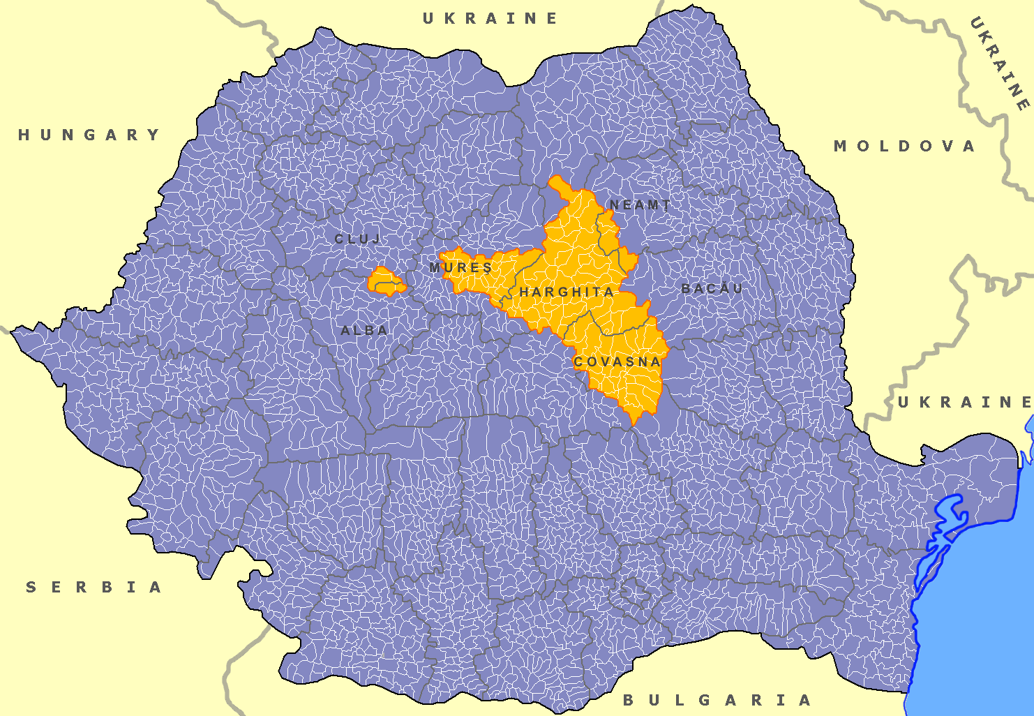
Covasna County (, hu, Kovászna megye, ) is a county ( județ) of Romania, in eastern Transylvania, with the county seat at Sfântu Gheorghe. Demographics In 2011, it had a population of 210,177, making it the second least populous of Romania's 41 counties and the population density was . In 2002 the ethnic composition of the county was as follows: * Hungarians – 73.58% (or 164,158) * Romanians – 23.28% (or 51,790) * Romani – 2.68% (or 5,973) According to the 2011 census, the composition of the county was: * Hungarians – 73.74% (or 150,468) * Romanians – 22.02% (or 45,021) * Romani – 4.05% (or 8,267) * Others - 0.19% Covasna County has the second-greatest percentage of Hungarian population in Romania, just behind the neighboring county of Harghita. The Hungarians of Covasna are primarily Székelys. Geography Covasna county has a total area of . The main part of the relief consists of mountains from the Eastern Carpathians group. Most localities can be found ... [...More Info...] [...Related Items...] OR: [Wikipedia] [Google] [Baidu] |
Poian
Poian ( hu, Kézdiszentkereszt, Hungarian pronunciation: ) is a commune in Covasna County, Transylvania, Romania composed of two villages: *Belani / Bélafalva *Poian / Kézdiszentkereszt History It formed part of the Székely Land region of the historical Transylvania province. Until 1918, the village belonged to the Háromszék County of the Kingdom of Hungary. After the Treaty of Trianon of 1920, it became part of Romania. In 2005, Estelnic, along with two other villages, broke away from Poian to form an independent commune. Demographics The commune has an absolute Székely Székely may refer to: *Székelys, Hungarian people from the historical region of Transylvania, Romania **Székely Land, historic and ethnographic area in Transylvania, Romania * Székely (village), a village in northeastern Hungary *Székely (sur ... Hungarian majority. According to the 2002 census, it has a population of 1,765 of which 99.43% or 1,755 are Hungarian. References {{Covasna Coun ... [...More Info...] [...Related Items...] OR: [Wikipedia] [Google] [Baidu] |
Transylvania
Transylvania ( ro, Ardeal or ; hu, Erdély; german: Siebenbürgen) is a historical and cultural region in Central Europe, encompassing central Romania. To the east and south its natural border is the Carpathian Mountains, and to the west the Apuseni Mountains. Broader definitions of Transylvania also include the western and northwestern Romanian regions of Crișana and Maramureș, and occasionally Banat. Transylvania is known for the scenery of its Carpathian landscape and its rich history. It also contains Romania's second-largest city, Cluj-Napoca, and other iconic cities and towns such as Brașov, Sibiu, Târgu Mureș, Alba Iulia and Sighișoara. It is also the home of some of Romania's List of World Heritage Sites in Romania, UNESCO World Heritage Sites such as the villages with fortified churches in Transylvania, Villages with fortified churches, the Historic Centre of Sighișoara, the Dacian Fortresses of the Orăștie Mountains and the Rosia Montana Mining Cultural Landsc ... [...More Info...] [...Related Items...] OR: [Wikipedia] [Google] [Baidu] |
Romania
Romania ( ; ro, România ) is a country located at the crossroads of Central Europe, Central, Eastern Europe, Eastern, and Southeast Europe, Southeastern Europe. It borders Bulgaria to the south, Ukraine to the north, Hungary to the west, Serbia to the southwest, Moldova to the east, and the Black Sea to the southeast. It has a predominantly Temperate climate, temperate-continental climate, and an area of , with a population of around 19 million. Romania is the List of European countries by area, twelfth-largest country in Europe and the List of European Union member states by population, sixth-most populous member state of the European Union. Its capital and largest city is Bucharest, followed by Iași, Cluj-Napoca, Timișoara, Constanța, Craiova, Brașov, and Galați. The Danube, Europe's second-longest river, rises in Germany's Black Forest and flows in a southeasterly direction for , before emptying into Romania's Danube Delta. The Carpathian Mountains, which cross Roma ... [...More Info...] [...Related Items...] OR: [Wikipedia] [Google] [Baidu] |
Székely Land
The Székely Land or Szeklerland ( hu, Székelyföld, ; ro, Ținutul Secuiesc and sometimes ; german: Szeklerland; la, Terra Siculorum) is a historic and ethnographic area in Romania, inhabited mainly by Székelys, a subgroup of Hungarians. Its cultural centre is the city of Târgu Mureș (Marosvásárhely), the largest settlement in the region. Székelys (or Szeklers) live in the valleys and hills of the Eastern Carpathian Mountains, corresponding mostly to the present-day Harghita, Covasna, and parts of Mureș counties in Romania. Originally, the name ''Székely Land'' denoted the territories of a number of autonomous Székely seats within Transylvania. The self-governing Székely seats had their own administrative system, and existed as legal entities from medieval times until the 1870s. The privileges of the Székely and Saxon seats were abolished and seats were replaced with counties in 1876. Along with Transylvania and eastern parts of Hungary proper, the Széke ... [...More Info...] [...Related Items...] OR: [Wikipedia] [Google] [Baidu] |
Háromszék County
Háromszék (''Three Seats''; Romanian: ''Trei Scaune'') was an administrative county (comitatus) of the Kingdom of Hungary. Situated in south-eastern Transylvania, its territory is now in central Romania (in the counties of Covasna, Brașov and Bacău). The capital of the county was Sepsiszentgyörgy (now Sfântu Gheorghe). Geography Háromszék county shared borders with Romania and the Hungarian counties Csík, Udvarhely, Nagy-Küküllő, and Brassó. The river Olt flowed through the county. The Carpathian Mountains formed its southern and eastern border. Its area was around 1910. History Háromszék means "three seats". Háromszék County was a combination of three seats of the Székelys: Kézdiszék, Orbaiszék, and Sepsiszék (plus some villages of the former Felső-Fehér County). The county was formed in 1876, when the administrative structure of Transylvania was changed. In 1920, under the Treaty of Trianon, the county became part of Romania under the name Trei S ... [...More Info...] [...Related Items...] OR: [Wikipedia] [Google] [Baidu] |
Kingdom Of Hungary
The Kingdom of Hungary was a monarchy in Central Europe that existed for nearly a millennium, from the Middle Ages into the 20th century. The Principality of Hungary emerged as a Christian kingdom upon the coronation of the first king Stephen I at Esztergom around the year 1000;Kristó Gyula – Barta János – Gergely Jenő: Magyarország története előidőktől 2000-ig (History of Hungary from the prehistory to 2000), Pannonica Kiadó, Budapest, 2002, , p. 687, pp. 37, pp. 113 ("Magyarország a 12. század második felére jelentős európai tényezővé, középhatalommá vált."/"By the 12th century Hungary became an important European factor, became a middle power.", "A Nyugat részévé vált Magyarország.../Hungary became part of the West"), pp. 616–644 his family (the Árpád dynasty) led the monarchy for 300 years. By the 12th century, the kingdom became a European middle power within the Western world. Due to the Ottoman occupation of the central and south ... [...More Info...] [...Related Items...] OR: [Wikipedia] [Google] [Baidu] |
Treaty Of Trianon
The Treaty of Trianon (french: Traité de Trianon, hu, Trianoni békeszerződés, it, Trattato del Trianon) was prepared at the Paris Peace Conference (1919–1920), Paris Peace Conference and was signed in the Grand Trianon château in Versailles on 4 June 1920. It formally ended World War I between most of the Allies of World War I and the Kingdom of Hungary. French diplomats played the major role in designing the treaty, with a view to establishing a French-led coalition of the newly formed states. It regulated the status of the Kingdom of Hungary and defined its borders generally within the #Borders of Hungary, ceasefire lines established in November–December 1918 and left Hungary as a Landlocked country, landlocked state that included , 28% of the that had constituted the pre-war Lands of the Crown of Saint Stephen, Kingdom of Hungary (the Hungarian half of the Austria-Hungary, Austro-Hungarian monarchy). The truncated kingdom had a population of 7.6 million, 36% ... [...More Info...] [...Related Items...] OR: [Wikipedia] [Google] [Baidu] |
Székelys
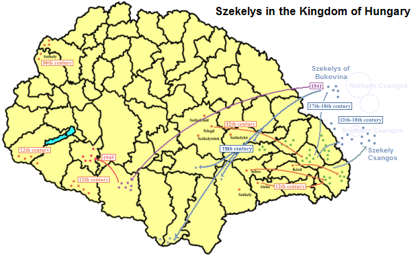
The Székelys (, Székely runes: 𐳥𐳋𐳓𐳉𐳗), also referred to as Szeklers,; ro, secui; german: Szekler; la, Siculi; sr, Секељи, Sekelji; sk, Sikuli are a Hungarian subgroup living mostly in the Székely Land in Romania. A significant population descending from the Székelys of Bukovina lives in Tolna and Baranya counties in Hungary and certain districts of Vojvodina, Serbia. In the Middle Ages, the Székelys played a role in the defense of the Kingdom of Hungary against the Ottomans in their posture as guards of the eastern border. With the Treaty of Trianon of 1920, Transylvania (including the Székely Land) became part of Romania, and the Székely population was a target of Romanianization efforts. In 1952, during the communist rule of Romania, the former counties with the highest concentration of Székely population – Mureș, Odorhei, Ciuc, and Trei Scaune – were legally designated as the Magyar Autonomous Region. It was superseded in 1960 ... [...More Info...] [...Related Items...] OR: [Wikipedia] [Google] [Baidu] |
Hungarian People
Hungarians, also known as Magyars ( ; hu, magyarok ), are a nation and ethnic group native to Hungary () and Kingdom of Hungary, historical Hungarian lands who share a common Hungarian culture, culture, Hungarian history, history, Magyar tribes, ancestry, and Hungarian language, language. The Hungarian language belongs to the Uralic languages, Uralic language family. There are an estimated 15 million ethnic Hungarians and their descendants worldwide, of whom 9.6 million live in today's Hungary. About 2–3 million Hungarians live in areas that were part of the Kingdom of Hungary before the Treaty of Trianon in 1920 and are now parts of Hungary's seven neighbouring countries, Hungarians in Slovakia, Slovakia, Hungarians in Ukraine, Ukraine, Hungarians in Romania, Romania, Hungarians in Serbia, Serbia, Hungarians of Croatia, Croatia, Prekmurje, Slovenia, and Hungarians in Austria, Austria. Hungarian diaspora, Significant groups of people with Hungarian ancestry live in various oth ... [...More Info...] [...Related Items...] OR: [Wikipedia] [Google] [Baidu] |
Census
A census is the procedure of systematically acquiring, recording and calculating information about the members of a given population. This term is used mostly in connection with national population and housing censuses; other common censuses include censuses of agriculture, traditional culture, business, supplies, and traffic censuses. The United Nations (UN) defines the essential features of population and housing censuses as "individual enumeration, universality within a defined territory, simultaneity and defined periodicity", and recommends that population censuses be taken at least every ten years. UN recommendations also cover census topics to be collected, official definitions, classifications and other useful information to co-ordinate international practices. The UN's Food and Agriculture Organization (FAO), in turn, defines the census of agriculture as "a statistical operation for collecting, processing and disseminating data on the structure of agriculture, covering th ... [...More Info...] [...Related Items...] OR: [Wikipedia] [Google] [Baidu] |


