|
Enmyvaam River
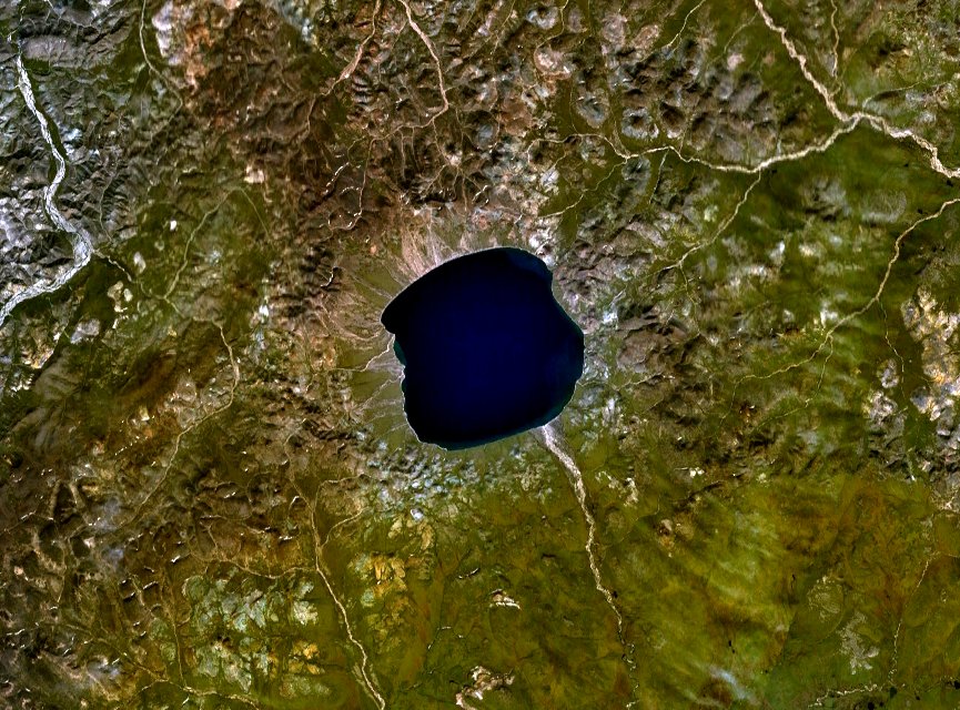
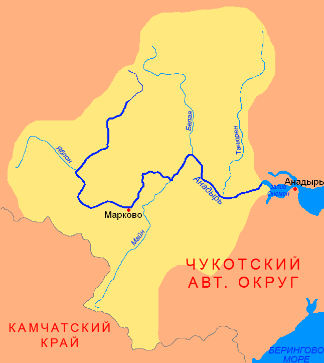
The Enmyvaam (russian: Энмываам, also spelled ''Enmywaam'' or ''Emmyvaam'' in English) is a river located in the Chukotka Autonomous Okrug in the Russian Far East, about southeast of Chaunskaya Bay. It is fed by and is the main and only outflow of Lake Elgygytgyn, draining into the Belaya, which drains into the Anadyr and eventually the Bering Sea. The river flows in the southern direction. It is long, and has a drainage basin of . It is located within the Anadyr river basin in the Anadyr—Kolyma watershed district. The name "Enmyvaam" comes from the Chukchi language Chukchi , also known as Chukot, is a Chukotko-Kamchatkan languages, Chukotko–Kamchatkan language spoken by the Chukchi people in the easternmost extremity of Siberia, mainly in Chukotka Autonomous Okrug. The language is closely related to Koryak ... and means "a river with rocky shores". References {{reflist Rivers of Chukotka Autonomous Okrug ... [...More Info...] [...Related Items...] OR: [Wikipedia] [Google] [Baidu] |
Lake Elgygytgyn
Lake El'gygytgyn (Russian and Chukchi: Эльгыгытгын) is an impact crater lake located in the Chukotka Autonomous Okrug in northeast Siberia, about southeast of Chaunskaya Bay. The word "Elgygytgyn" means "white lake" in the Chukchi language. The lake is of particular interest to scientists because it has never been covered by glaciers. This has allowed the uninterrupted build-up of of sediment at the bottom of the lake, recording information on prehistoric climate change. Geography Lake El'gygytgyn is located in the Anadyr Plateau, part of the Anadyr Highlands. It is drained to the southeast by the Enmyvaam, a tributary of the Belaya. It is approximately in diameter and has a maximum depth of . The lake is centered within an impact crater with a rim diameter of that formed 3.6 million years ago during the Pliocene. Before it was reliably dated, preliminary papers in the late 1970s suggested either Elgygytgyn or Zhamanshin as the source of the young Austra ... [...More Info...] [...Related Items...] OR: [Wikipedia] [Google] [Baidu] |
Belaya (Chukotka)
The Belaya (russian: Бе́лая, in its upper course Юрумкувеем ''Yurumkuveyem'') is a south-flowing tributary of the in the administrative region of . Course The source of the Yurumkuveyem is in the northern |
Russia
Russia (, , ), or the Russian Federation, is a List of transcontinental countries, transcontinental country spanning Eastern Europe and North Asia, Northern Asia. It is the List of countries and dependencies by area, largest country in the world, with its internationally recognised territory covering , and encompassing one-eighth of Earth's inhabitable landmass. Russia extends across Time in Russia, eleven time zones and shares Borders of Russia, land boundaries with fourteen countries, more than List of countries and territories by land borders, any other country but China. It is the List of countries and dependencies by population, world's ninth-most populous country and List of European countries by population, Europe's most populous country, with a population of 146 million people. The country's capital and List of cities and towns in Russia by population, largest city is Moscow, the List of European cities by population within city limits, largest city entirely within E ... [...More Info...] [...Related Items...] OR: [Wikipedia] [Google] [Baidu] |
English Language
English is a West Germanic language of the Indo-European language family, with its earliest forms spoken by the inhabitants of early medieval England. It is named after the Angles, one of the ancient Germanic peoples that migrated to the island of Great Britain. Existing on a dialect continuum with Scots, and then closest related to the Low Saxon and Frisian languages, English is genealogically West Germanic. However, its vocabulary is also distinctively influenced by dialects of France (about 29% of Modern English words) and Latin (also about 29%), plus some grammar and a small amount of core vocabulary influenced by Old Norse (a North Germanic language). Speakers of English are called Anglophones. The earliest forms of English, collectively known as Old English, evolved from a group of West Germanic (Ingvaeonic) dialects brought to Great Britain by Anglo-Saxon settlers in the 5th century and further mutated by Norse-speaking Viking settlers starting in the 8th and 9th ... [...More Info...] [...Related Items...] OR: [Wikipedia] [Google] [Baidu] |
Chukotka Autonomous Okrug
Chukotka (russian: Чуко́тка), officially the Chukotka Autonomous Okrug,, ''Čukotkakèn avtonomnykèn okrug'', is the easternmost federal subjects of Russia, federal subject of Russia. It is an autonomous okrug situated in the Russian Far East, and shares a border with the Sakha, Sakha Republic to the west, Magadan Oblast to the south-west, and Kamchatka Krai to the south. Anadyr (town), Anadyr is the largest types of inhabited localities in Russia, town and the administrative center, capital, and the easternmost settlement to have town status in Russia. Chukotka is primarily populated by ethnic Russians, Chukchi people, Chukchi, and other Indigenous peoples of Siberia, indigenous peoples. It is the only autonomous okrug in Russia that is not included in, or subordinate to, another federal subject, having separated from Magadan Oblast in 1992. It is home to Lake Elgygytgyn, an impact crater lake, and Anyuyskiy, an extinct volcano. The village of Uelen is the easternmos ... [...More Info...] [...Related Items...] OR: [Wikipedia] [Google] [Baidu] |
Russian Far East
The Russian Far East (russian: Дальний Восток России, r=Dal'niy Vostok Rossii, p=ˈdalʲnʲɪj vɐˈstok rɐˈsʲiɪ) is a region in Northeast Asia. It is the easternmost part of Russia and the Asian continent; and is administered as part of the Far Eastern Federal District, which is located between Lake Baikal in eastern Siberia and the Pacific Ocean. The area's largest city is Khabarovsk, followed by Vladivostok. The region shares land borders with the countries of Mongolia, China, and North Korea to its south, as well as maritime boundaries with Japan to its southeast, and with the United States along the Bering Strait to its northeast. The Russian Far East is often considered as a part of Siberia (previously during the Soviet era when it was called the Soviet Far East). Terminology In Russia, the region is usually referred to as just "Far East" (). What is known in English as the Far East is usually referred to as "the Asia-Pacific Region" (, abbrevia ... [...More Info...] [...Related Items...] OR: [Wikipedia] [Google] [Baidu] |
Chaunskaya Bay
The Chaunskaya Bay or Chaun Bay (russian: Чаунская губа) is an Arctic bay in the East Siberian Sea, in the Chaunsky District of Chukotka, northeast Siberia. There is Port of Pevek. Geography The bay is open to the north and is 140 km in length. Its maximum width is 110 km.GoogleEarth Its mouth is defined by Cape Shelagsky, the end of the Shelag Range, to the east and an unnamed part of Ayon Island to the west. It narrows where the Pevek Peninsula on the east approaches Ayon Island. Owing to is northerly location Chaunskaya Bay is covered with ice most of the year. This bay is the center of one of the larger lowlands in Chukotka. A number of rivers flow into the southeastern corner: Chaun River, Ichuveyem River, Palyavaam River, Lelyuveyem River and Pucheveyem River. There is a protected natural area in the southeast. Lake Elgygytgyn is about 160 km southeast and the town of Bilibino about 160 km southwest. History The first Russian to reac ... [...More Info...] [...Related Items...] OR: [Wikipedia] [Google] [Baidu] |
Discharge (hydrology)
In hydrology, discharge is the volumetric flow rate of water that is transported through a given cross-sectional area. It includes any suspended solids (e.g. sediment), dissolved chemicals (e.g. CaCO3(aq)), or biologic material (e.g. diatoms) in addition to the water itself. Terms may vary between disciplines. For example, a fluvial hydrologist studying natural river systems may define discharge as streamflow, whereas an engineer operating a reservoir system may equate it with outflow, contrasted with inflow. Theory and calculation A discharge is a measure of the quantity of any fluid flow over unit time. The quantity may be either volume or mass. Thus the water discharge of a tap (faucet) can be measured with a measuring jug and a stopwatch. Here the discharge might be 1 litre per 15 seconds, equivalent to 67 ml/second or 4 litres/minute. This is an average measure. For measuring the discharge of a river we need a different method and the most common is the 'area-velocity' method. ... [...More Info...] [...Related Items...] OR: [Wikipedia] [Google] [Baidu] |
Anadyr (river)
The Anadyr (russian: Ана́дырь; Yukaghir: Онандырь; ckt, Йъаайваам) is a river in the far northeast of Siberia which flows into the Gulf of Anadyr of the Bering Sea and drains much of the interior of Chukotka Autonomous Okrug. Its basin corresponds to the Anadyrsky District of Chukotka. Geography The Anadyr is long and has a basin of . It is frozen from October to late May and has a maximum flow in June with the snowmelt. It is navigable in small boats for about to near Markovo. West of Markovo it is in the Anadyr Highlands (moderate mountains and valleys with a few trees) and east of Markovo it moves into the Anadyr Lowlands (very flat treeless tundra with lakes and bogs). The drop from Markovo to the sea is less than . It rises at about 67°N latitude and 171°E longitude in the Anadyr Highlands, near the headwaters of the Maly Anyuy, flows southwest receiving the waters of the rivers Yablon and Yeropol, turns east around the Shchuchy Range and ... [...More Info...] [...Related Items...] OR: [Wikipedia] [Google] [Baidu] |
Bering Sea
The Bering Sea (, ; rus, Бе́рингово мо́ре, r=Béringovo móre) is a marginal sea of the Northern Pacific Ocean. It forms, along with the Bering Strait, the divide between the two largest landmasses on Earth: Eurasia and The Americas. It comprises a deep water basin, which then rises through a narrow slope into the shallower water above the continental shelf, continental shelves. The Bering Sea is named for Vitus Bering, a Denmark, Danish navigator in Russian service, who, in 1728, was the first European to systematically explore it, sailing from the Pacific Ocean northward to the Arctic Ocean. The Bering Sea is separated from the Gulf of Alaska by the Alaska Peninsula. It covers over and is bordered on the east and northeast by Alaska, on the west by the Russian Far East and the Kamchatka Peninsula, on the south by the Alaska Peninsula and the Aleutian Islands and on the far north by the Bering Strait, which connects the Bering Sea to the Arctic Ocean's Chukchi ... [...More Info...] [...Related Items...] OR: [Wikipedia] [Google] [Baidu] |
Watershed District (Russia)
A watershed district (russian: Бассейновый округ, Basseynovy okrug) in Russia is any of twenty groups of water bodies listed in the Water Code of Russian Federation, serving as the main unit of management in the field of use and protection of water bodies. According to chapter 4, article 28 of the Russian Water Code, those are: Baltic Watershed District, Barents– Belomor Watershed District, Dvina–Pechora Watershed District, Dnieper Watershed District, Don Watershed District, Kuban Watershed District, Western Caspian Watershed District, Upper Volga Watershed District, Oka Watershed District, Kama Watershed District, Lower Volga Watershed District, Ural Watershed District, Upper Ob Watershed District, Irtysh Watershed District, Lower Ob Watershed District, Angara–Baikal Watershed District, Yenisey Watershed District, Lena Watershed District, Anadyr–Kolyma Watershed District and Amur The Amur (russian: река́ Аму́р, ), or Heilong Jiang (, "Bla ... [...More Info...] [...Related Items...] OR: [Wikipedia] [Google] [Baidu] |
Chukchi Language
Chukchi , also known as Chukot, is a Chukotko-Kamchatkan languages, Chukotko–Kamchatkan language spoken by the Chukchi people in the easternmost extremity of Siberia, mainly in Chukotka Autonomous Okrug. The language is closely related to Koryak language, Koryak. Chukchi, Koryak, Kerek language, Kerek, Alutor language, Alutor, and Itelmen language, Itelmen form the Chukotko-Kamchatkan Language families and languages, language family. There are many cultural similarities between the Chukchis and Koryaks, including economies based on reindeer herding. Both peoples refer to themselves by the endonym ''Luorawetlat'' (ԓыгъоравэтԓьат ; singular ''Luorawetlan'' ԓыгъоравэтԓьан ), meaning "the real people". All of these peoples and other unrelated minorities in and around Kamchatka are known collectively as Kamchadals. ''Chukchi'' and ''Chukchee'' are anglicisation, anglicized versions of the Russian exonym ''Chukcha'' (plural ''Chukchi''). This came into Russi ... [...More Info...] [...Related Items...] OR: [Wikipedia] [Google] [Baidu] |


