|
Elmstone
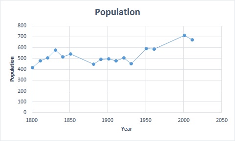
Elmstone is a hamlet in the Preston civil parish in East Kent, England. It is situated between Canterbury and Sandwich. The Domesday Book of 1086 records Elmstone as 'AElvetone'. In 1086 the recorded population was 3 households. The village is surrounded by farmland mostly laid to apple and pear orchards. Some local farms have been sold and are no longer used for agriculture. Elmstone Church, a small 13th-century Anglican church can be found in the village; unusually, the church does not have a dedicated saint. The church, in the Canonry Benefice of Canterbury diocese, shares a vicar with the villages of Ash, Chillenden, Goodnestone, Nonington, Preston and Stourmouth. Elmstone recorded the lowest temperature (−21.3 °C (−6.3 °F) during the Winter of 1946–1947 Winter is the coldest season of the year in polar and temperate climates. It occurs after autumn and before spring. The tilt of Earth's axis causes seasons; winter occurs when a hemisphere is or ... [...More Info...] [...Related Items...] OR: [Wikipedia] [Google] [Baidu] |
Elmstone Church
Elmstone Church is an Anglican church in the village of Elmstone in Kent, England. The church dates back to the 13th century, and was designated a Grade II* listed building in 1963. Unusually for churches in the United Kingdom, Elmstone Church does not feature a dedication to any saint. History and architecture The nave and lower chancel are from Norman times and are built out of flint. The chancel contains a north window and the nave contains two south windows; all three have Caen stone heads and sills, as well as jambs made of flint. Early 14th-century remodelling is visible in the Y-tracery of the west window, and in the three-light east window which contains intersecting tracery. There is also evidence of an early 14th-century enlargement, specifically the north aisle and the north-west tower, both being built out of squared knapped flint. The church also boasts square-headed windows with ogee lights. The porch is situated to the south. There is an arcade of three bays typic ... [...More Info...] [...Related Items...] OR: [Wikipedia] [Google] [Baidu] |
Preston-next-Wingham
Preston or Preston-next-Wingham is a civil parish and village in the valley of the Little Stour in the Dover District of Kent, England. The village is on the B2076 secondary road. The parish includes the hamlet of Elmstone. The main river through the area is a tributary of the River Stour. The suffix 'next-Wingham' distinguishes the area from Preston-next-Faversham. The Domesday Book of 1086 chronicled Preston as 'Prestetune'. In the 1870s, Preston-next-Wingham was described as:"A village and a parish in Eastry district, Kent. The village stands on a rising-ground, above the marshes of the Little Stour river, 1½mile S E of Grove-Ferry r. station, and 6¾ E N E of Canterbury; bears the name of Preston-street, and has a postal pillar-box under Wingham". The Village Preston is located 10 miles east of Canterbury, and a mile south of the Stodmarsh National Nature Reserve. The village houses are fairly scattered. It retains a primary school, a local pub, a butchers, a village shop ... [...More Info...] [...Related Items...] OR: [Wikipedia] [Google] [Baidu] |
Winter Of 1946–47 In The United Kingdom
The winter of 1946–1947 was a harsh European winter noted for its adverse effects in the United Kingdom. It caused severe hardships in economic terms and living conditions in a country still recovering from the Second World War. There were massive disruptions of energy supply for homes, offices and factories. Animal herds froze or starved to death. People suffered from the persistent cold, and many businesses shut down temporarily. When warm weather returned, the ice thawed and flooding was severe in most low-lying areas. Beginning on 23 January 1947, the UK experienced several cold spells that brought large drifts of snow to the country, blocking roads and railways, which caused problems transporting coal to the electric power stations. Many had to shut down, forcing severe restrictions to cut power consumption, including restricting domestic electricity to nineteen hours per day and cutting some industrial supplies completely. In addition, radio broadcasts were limited, tel ... [...More Info...] [...Related Items...] OR: [Wikipedia] [Google] [Baidu] |
Villages In Kent ...
__NOTOC__ See also *List of settlements in Kent by population * List of civil parishes in Kent * :Civil parishes in Kent * :Towns in Kent * :Villages in Kent * :Geography of Kent *List of places in England {{Kent Places Kent Kent is a county in South East England and one of the home counties. It borders Greater London to the north-west, Surrey to the west and East Sussex to the south-west, and Essex to the north across the estuary of the River Thames; it faces ... [...More Info...] [...Related Items...] OR: [Wikipedia] [Google] [Baidu] |
Dover (district)
Dover is a local government district in Kent, England. The port town of Dover is its administrative centre. It was formed on 1 April 1974 by the merger of the boroughs of Deal, Dover, and Sandwich along with Dover Rural District and most of Eastry Rural District. Settlements There are three towns within the district: Deal, Dover and Sandwich; and the parishes below: * Alkham * Ash * Aylesham * Capel-le-Ferne * Denton with Wootton * Eastry * Eythorne * Goodnestone * Great Mongeham * Guston * Hougham Without * Langdon * Lydden * Nonington * Northbourne * Preston * Ringwould with Kingsdown * Ripple * River * Shepherdswell with Coldred * Sholden * St Margaret's at Cliffe * Staple * Stourmouth * Sutton * Temple Ewell * Tilmanstone * Walmer * Whitfield * Wingham * Woodnesborough * Worth The northern boundary of the district is the River Stour; on its western side is the district of Canterbury; to the south the parish of Capel-le-Ferne; and to the east the Straits of Dove ... [...More Info...] [...Related Items...] OR: [Wikipedia] [Google] [Baidu] |
Kent
Kent is a county in South East England and one of the home counties. It borders Greater London to the north-west, Surrey to the west and East Sussex to the south-west, and Essex to the north across the estuary of the River Thames; it faces the French department of Pas-de-Calais across the Strait of Dover. The county town is Maidstone. It is the fifth most populous county in England, the most populous non-Metropolitan county and the most populous of the home counties. Kent was one of the first British territories to be settled by Germanic tribes, most notably the Jutes, following the withdrawal of the Romans. Canterbury Cathedral in Kent, the oldest cathedral in England, has been the seat of the Archbishops of Canterbury since the conversion of England to Christianity that began in the 6th century with Saint Augustine. Rochester Cathedral in Medway is England's second-oldest cathedral. Located between London and the Strait of Dover, which separates England from mainla ... [...More Info...] [...Related Items...] OR: [Wikipedia] [Google] [Baidu] |
Canterbury
Canterbury (, ) is a City status in the United Kingdom, cathedral city and UNESCO World Heritage Site, situated in the heart of the City of Canterbury local government district of Kent, England. It lies on the River Stour, Kent, River Stour. The Archbishop of Canterbury is the primate (bishop), primate of the Church of England and the worldwide Anglican Communion owing to the importance of Augustine of Canterbury, St Augustine, who served as the apostle to the Anglo-Saxon paganism, pagan Kingdom of Kent around the turn of the 7th century. The city's Canterbury Cathedral, cathedral became a major focus of Christian pilgrimage, pilgrimage following the 1170 Martyr of the Faith, martyrdom of Thomas Becket, although it had already been a well-trodden pilgrim destination since the murder of Ælfheah of Canterbury, St Alphege by the men of cnut, King Canute in 1012. A journey of pilgrims to Becket's shrine served as the narrative frame, frame for Geoffrey Chaucer's 14th-century Wes ... [...More Info...] [...Related Items...] OR: [Wikipedia] [Google] [Baidu] |
Sandwich, Kent
Sandwich is a town and civil parish in the Dover District of Kent, south-east England. It lies on the River Stour and has a population of 4,985. Sandwich was one of the Cinque Ports and still has many original medieval buildings, including several listed public houses and gates in the old town walls, churches, almshouses and the White Mill. While once a major port, it is now two miles from the sea due to the disappearance of the Wantsum Channel. Its historic centre has been preserved. Sandwich Bay is home to nature reserves and two world-class golf courses, Royal St George's and Prince's. The town is also home to many educational and cultural events. Sandwich also gave its name to the food by way of John Montagu, 4th Earl of Sandwich, and the word ''sandwich'' is now found in several languages. Etymology The place-name 'Sandwich' is first attested in the ''Anglo-Saxon Chronicle'', where it appears as ' in 851 and ' in 993. In the ''Domesday Book'' of 1086 it appears as '. T ... [...More Info...] [...Related Items...] OR: [Wikipedia] [Google] [Baidu] |
Domesday Book
Domesday Book () – the Middle English spelling of "Doomsday Book" – is a manuscript record of the "Great Survey" of much of England and parts of Wales completed in 1086 by order of King William I, known as William the Conqueror. The manuscript was originally known by the Latin name ''Liber de Wintonia'', meaning "Book of Winchester", where it was originally kept in the royal treasury. The '' Anglo-Saxon Chronicle'' states that in 1085 the king sent his agents to survey every shire in England, to list his holdings and dues owed to him. Written in Medieval Latin, it was highly abbreviated and included some vernacular native terms without Latin equivalents. The survey's main purpose was to record the annual value of every piece of landed property to its lord, and the resources in land, manpower, and livestock from which the value derived. The name "Domesday Book" came into use in the 12th century. Richard FitzNeal wrote in the ''Dialogus de Scaccario'' ( 1179) that the book ... [...More Info...] [...Related Items...] OR: [Wikipedia] [Google] [Baidu] |
Church Of England
The Church of England (C of E) is the established Christian church in England and the mother church of the international Anglican Communion. It traces its history to the Christian church recorded as existing in the Roman province of Britain by the 3rd century and to the 6th-century Gregorian mission to Kent led by Augustine of Canterbury. The English church renounced papal authority in 1534 when Henry VIII failed to secure a papal annulment of his marriage to Catherine of Aragon. The English Reformation accelerated under Edward VI's regents, before a brief restoration of papal authority under Queen Mary I and King Philip. The Act of Supremacy 1558 renewed the breach, and the Elizabethan Settlement charted a course enabling the English church to describe itself as both Reformed and Catholic. In the earlier phase of the English Reformation there were both Roman Catholic martyrs and radical Protestant martyrs. The later phases saw the Penal Laws punish Ro ... [...More Info...] [...Related Items...] OR: [Wikipedia] [Google] [Baidu] |


_-_geograph.org.uk_-_650895.jpg)

