|
Ellough
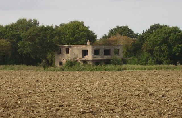
Ellough is a civil parish in the East Suffolk district of the English county of Suffolk, located approximately south-east of Beccles. The area is sparsely populated with a mid-2005 population estimate of 40. The parish, which has an area of , borders Worlingham, North Cove, Mutford, Weston, Sotterley, Willingham St Mary and Henstead with Hulver Street. The parish council operates to administer jointly the parishes of Shadingfield, Willingham St Mary, Sotterley and Ellough. The village was the site of a World War II airfield built in 1943 and operated today as Beccles Airfield. Part of the former airfield is used as a kart racetrack and as an industrial estate, including the main production site of local printing firm William Clowes Ltd. The village itself is dispersed and has few services. [...More Info...] [...Related Items...] OR: [Wikipedia] [Google] [Baidu] |
All Saints Church, Ellough
All Saints Church is a redundant Anglican church in the parish of Ellough, Suffolk, England. The church is medieval in origin and is recorded in the National Heritage List for England as a designated Grade I listed building, and is under the care of the Churches Conservation Trust. The church stands in an isolated position on the top of a low hill, some to the south-east of Beccles. History The church dates from the 14th century, and a south porch was added in 1602, paid for by Thomas Love. Suckling. A. (1846) 'Ellough, or Willingham All Saints', ''The History and Antiquities of the County of Suffolk: volume 1'', pp. 53–57available online. Retrieved 2011-06-25. Wall paintings were removed in 1643 when William Dowling, a strict puritan, visited the church. Land from the glebe of the church of St Marys in Willingham St Mary, the site of which is visible from the church, was consolidated with Ellough in the 18th century. The church was restored in 1882 by William ... [...More Info...] [...Related Items...] OR: [Wikipedia] [Google] [Baidu] |
Ellough Park Raceway
Ellough Park Raceway is a kart racing track in Ellough in the English county of Suffolk. It is located around south-east of the market town of Beccles. It is primarily used for kart racing as it is a fast, but tight and twisty circuit. The track, which is fully floodlit, has existed on the old Ellough Airfield since the early 1960s, but was not fully developed until 2000, when ex-Formula 1 driver Jackie Oliver opened the circuit. The authorities at the circuit extended it in 2007, from 800m to just over 1000m to make it more suitable for other forms of kart and minimoto A minibike is a two-wheeled, motorized, off-highway recreational vehicle popularized in the 1960s and 1970s, but available continuously from a wide variety of manufacturers since 1959. Their off-highway nature and (in many countries) typically enti ... racing. The circuit was extended further in 2010 to incorporate a new pits complex and add extra paddock space for hosting the Formula Kart Stars championship. ... [...More Info...] [...Related Items...] OR: [Wikipedia] [Google] [Baidu] |
Beccles Airfield
Beccles Airfield, also known as Beccles Airport or Beccles Aerodrome , is located in Ellough, southeast of Beccles in the English county of Suffolk. Built during the second world war, it has operated as a heliport servicing the North Sea oil and gas industry and currently operates as a base for private flights, flight training and parachuting. Beccles Aerodrome has a CAA Ordinary Licence (Number P837) that allows flights for the public transport of passengers or for flying instruction as authorised by the licensee (RainAir (Beccles) Limited). The aerodrome is not licensed for night use. The current airstrip consists of around 450 metres of the original wartime concrete surface with 150 metres of grass airstrip.UK AIP – Beccles NATS aeronauti ... [...More Info...] [...Related Items...] OR: [Wikipedia] [Google] [Baidu] |
Willingham St Mary
Willingham St Mary, also known simply as Willingham, is a village and civil parish in the English county of Suffolk located about south of Beccles in the East Suffolk district. At the 2011 United Kingdom census it had a population of 152. The A145 road cuts through the western section of the parish where it joins with Shadingfield. Sections of the Sotterley estate are included within its western section.Shadingfield, Sotterley, Willingham & Ellough Healthy Suffolk, 2016. Retrieved 2021-02-10. A joint parish council covers the parishes of |
Beccles
Beccles ( ) is a market town and civil parish in the English county of Suffolk.OS Explorer Map OL40: The Broads: (1:25 000) : . The town is shown on the milestone as from London via the A145 and A12 roads, north-east of London as the crow flies, south-east of Norwich and north-northeast of the county town of Ipswich. Nearby towns include Lowestoft to the east and Great Yarmouth to the north-east. The town lies on the River Waveney on the edge of The Broads National Park. It had a population at the 2011 census of 10,123. Worlingham is a suburb of Beccles; the combined population is 13,868. Beccles twinned with Petit-Couronne in France in 1978. History The name is conjectured to be derived from Becc-Liss* (Brittonic=Small-court). However, also offered is Bece-laes* (Old English=Meadow by Stream), as well as a contraction of ''Beata Ecclesia'', the name of the Christian temple erected c. 960 by the monks of the monastery of Bury. Once a flourishing Anglian riverport, it lie ... [...More Info...] [...Related Items...] OR: [Wikipedia] [Google] [Baidu] |
Weston, Suffolk
Weston is a village and civil parish in the English county of Suffolk. It is around south of Beccles in the East Suffolk (district), East Suffolk district. The parish lies either side of the A145 road and is crossed by the East Suffolk Line, Ipswich to Lowestoft railway line.Ringsfield and Weston Healthy Suffolk, 2016. Retrieved 2020-02-09. Neighbouring parishes include Ellough, Ringsfield, Willingham St Mary and Shadingfield. The village is largely dispersed with a population of around 230. The village has few services and a joint Parish councils in England, parish council covers both Ringsfield and Weston.Ringsfie ... [...More Info...] [...Related Items...] OR: [Wikipedia] [Google] [Baidu] |
Shadingfield
Shadingfield is a village and civil parish in the East Suffolk district of the English county of Suffolk. It is located around south of Beccles in the north of the county. The village is spread along a stretch of the A145 road between Beccles and Blythburgh to the south.Shadingfield Suffolk Heritage Explorer, . Retrieved 2021-02-11. The Ipswich to Lowestoft railway line runs through the west of the parish, with the nearest stations at |
Sotterley
Sotterley, originally ''Southern-lea'' from its situation south of the river, Suckling, A.I., (1846). 'Sotterley', in ''The History and Antiquities of the County of Suffolk'', 2 vols (W.S. Cowell, Ipswich 1846), Ipp. 81–96(British History Online). Retrieved 2011-04-06. is a village and civil parish in the East Suffolk district, in the English county of Suffolk, located approximately south-east of Beccles and east of Willingham St Mary and Shadingfield. The parish is primarily agricultural with a dispersed population of 113 at the 2011 census.Village profile: Sotterley , ... [...More Info...] [...Related Items...] OR: [Wikipedia] [Google] [Baidu] |
North Cove
North Cove is a village and civil parish in the north of the English county of Suffolk. It is part of the East Suffolk district, located around east of Beccles and west of Lowestoft. It merges with the village of Barnby and the villages share some resources, although the two parishes retain separate parish councils.North Cove Healthy Suffolk, 2016. Retrieved 2021-02-10. The parish has an area of and at the had a population of 449. [...More Info...] [...Related Items...] OR: [Wikipedia] [Google] [Baidu] |
Henstead With Hulver Street
Henstead with Hulver Street is a civil parish in the East Suffolk district of the English county of Suffolk. It is around south-west of Lowestoft, south-east of Beccles and north of the coastal town of Southwold.Henstead and Hulver Street Healthy Suffolk, 2016. Retrieved 2020-02-08. The parish has an area of and consists of the villages of , where the parish church is located, and . It borders the parishes of Benacre, [...More Info...] [...Related Items...] OR: [Wikipedia] [Google] [Baidu] |
Worlingham
Worlingham is a village and civil parish in the East Suffolk district of the English county of Suffolk. It is about east of Beccles, with the two places effectively joined to form one urban area. At the 2011 census it had a population of 3,745; the combined population of Beccles and Worlingham is 13,868. The parish has increased in population in recent years due to the development of suburban housing areas within the built up area, going up by over 13% between the 2001 and 2011 censuses.''Draft Worlingham Neighbourhood Plan 2020–2036'', January 2021. Worlingham is around west of Lowestoft and south-east of the major city of Norwich in Norfolk The parish is bordered to the north by the River Waveney and northern sections form part of The Broads National Park area. The Ipswich to Lowestoft railway line passes through this area, with the nearest railway station at Beccles. Other than Beccles, the parish borders the parishes of North Cove, Mutford, Ellough and Weston. To t ... [...More Info...] [...Related Items...] OR: [Wikipedia] [Google] [Baidu] |
Mutford
Mutford is a village and civil parish in the East Suffolk District of the English county of Suffolk. The village is south-west of Lowestoft and south-east of Beccles in a rural area. The parish borders Barnby, Carlton Colville, Gisleham, Rushmere, Henstead with Hulver Street, Ellough and North Cove. The village gave its name to the Half Hundred of Mutford which is named in the Domesday Book.Mutford Healthy Suffolk. Retrieved 2021-02-12. The parish had a population of 471 at the . The A146 Beccles to Lowestoft road runs to north of the parish, cutting t ... [...More Info...] [...Related Items...] OR: [Wikipedia] [Google] [Baidu] |


.jpg)