|
Ellenroad Mill
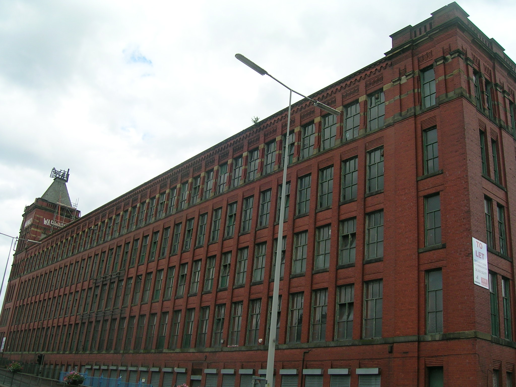
Ellenroad Mill was a cotton spinning mill in Newhey, a village in the Milnrow area of Rochdale, England. It was built as a mule spinning mill in 1890 by Stott and Sons and extended in 1899. It was destroyed by fire on 19 January 1916. When it was rebuilt, it was designed and equipped as a ring spinning mill. After closure, the mill itself was demolished in 1982, but the engine house – complete with steam engine – and the boiler house chimney were retained. Ownership passed to the Ellenroad Trust. The Ellenroad Ring Mill Engine is steamed on the first Sunday of the month (except January for boiler inspection). Location Ellenroad mill was situated on flat land alongside the river in Newhey (archaically "New Hey".) The village lies at the foot of the Pennines, in the valley of the River Beal, east-southeast of Rochdale and northeast of Manchester. Historically a part of Lancashire, Newhey was anciently a hamlet within the township of Butterworth. It was described in 1 ... [...More Info...] [...Related Items...] OR: [Wikipedia] [Google] [Baidu] |
Cotton-spinning Machinery
Cotton-spinning machinery is machines which process (or spin) prepared cotton roving into workable yarn or thread. Such machinery can be dated back centuries. During the 18th and 19th centuries, as part of the Industrial Revolution cotton-spinning machinery was developed to bring mass production to the cotton industry. Cotton spinning machinery was installed in large factories, commonly known as cotton mills. History Spinning wheel The spinning wheel was invented in the Islamic world by 1030. It later spread to China by 1090, and then spread from the Islamic world to Europe and India by the 13th century. Until the 1740s all spinning was done by hand using a spinning wheel. The state of the art spinning wheel in England was known as the Jersey wheel however an alternative wheel, the Saxony wheel was a double band treadle spinning wheel where the spindle rotated faster than the traveller in a ratio of 8:6, drawing on both was done by the spinners fingers. Lewis Paul and John Wy ... [...More Info...] [...Related Items...] OR: [Wikipedia] [Google] [Baidu] |
Hamlet (place)
A hamlet is a human settlement that is smaller than a town or village. Its size relative to a Parish (administrative division), parish can depend on the administration and region. A hamlet may be considered to be a smaller settlement or subdivision or satellite entity to a larger settlement. The word and concept of a hamlet has roots in the Anglo-Norman settlement of England, where the old French ' came to apply to small human settlements. Etymology The word comes from Anglo-Norman language, Anglo-Norman ', corresponding to Old French ', the diminutive of Old French ' meaning a little village. This, in turn, is a diminutive of Old French ', possibly borrowed from (West Germanic languages, West Germanic) Franconian languages. Compare with modern French ', Dutch language, Dutch ', Frisian languages, Frisian ', German ', Old English ' and Modern English ''home''. By country Afghanistan In Afghanistan, the counterpart of the hamlet is the Qila, qala (Dari language, Dari: ... [...More Info...] [...Related Items...] OR: [Wikipedia] [Google] [Baidu] |
Todmorden
Todmorden ( ; ) is a market town and civil parishes in England, civil parish in the Upper Calder Valley in Calderdale, West Yorkshire, England. It is north-east of Manchester, south-east of Burnley and west of Halifax, West Yorkshire, Halifax. In 2011 it had a population of 15,481. Todmorden is at the confluence of three steep-sided Pennines, Pennine valleys and is surrounded by moorlands with outcrops of Aeolian processes, sandblasted gritstone. The Historic counties of England, historic boundary between Yorkshire and Lancashire is the River Calder, West Yorkshire, River Calder and its tributary, Walsden Water, which run through the town. The administrative border was altered by the Local Government Act 1888 placing the whole of the town within the West Riding of Yorkshire, West Riding. The town is served by and railway stations. History Toponymy The name Todmorden first appears in 1641. The town had earlier been called Tottemerden, Totmardene, Totmereden or Totmerd ... [...More Info...] [...Related Items...] OR: [Wikipedia] [Google] [Baidu] |
Chadderton
Chadderton is a town in the Metropolitan Borough of Oldham, Greater Manchester, England, on the River Irk and Rochdale Canal. It is located in the foothills of the Pennines, west of Oldham, south of Rochdale and north-east of Manchester. Historically part of Lancashire, Chadderton's early history is marked by its status as a manorial township, with its own lords, who included the Asshetons, Chethams, Radclyffes and Traffords. Chadderton in the Middle Ages was chiefly distinguished by its two mansions, Foxdenton Hall and Chadderton Hall, and by the prestigious families who occupied them. Farming was the main industry of the area, with locals supplementing their incomes by hand-loom woollen weaving in the domestic system. Chadderton's urbanisation and expansion coincided largely with developments in textile manufacture during the Industrial Revolution and the Victorian era. A late-19th century factory-building boom transformed Chadderton from a rural township into a major mi ... [...More Info...] [...Related Items...] OR: [Wikipedia] [Google] [Baidu] |
Middleton, Greater Manchester
Middleton is a town in the Metropolitan Borough of Rochdale, Greater Manchester, England, on the River Irk southwest of Rochdale and northeast of Manchester city centre. Middleton had a population of 42,972 at the 2011 Census. It lies on the northern edge of Manchester, with Blackley to the south and Moston to the south east. Historically part of Lancashire, Middleton's name comes from it being the centre of several circumjacent settlements. It was an ecclesiastical parish of the hundred of Salford, ruled by aristocratic families. The Church of St Leonard is a Grade I listed building. The Flodden Window in the church's sanctuary is thought to be the oldest war memorial in the United Kingdom, memorialising the archers of Middleton who fought at the Battle of Flodden in 1513. In 1770, Middleton was a village of twenty houses, but in the 18th and 19th centuries it grew into a thriving and populous seat of textile manufacture and it was granted borough status in 1886. Langley ... [...More Info...] [...Related Items...] OR: [Wikipedia] [Google] [Baidu] |
Moston, Greater Manchester
Moston is a suburb of Manchester, in North West England, approximately north-east of the city centre. Historically in Lancashire, Moston is a predominantly residential area, with a population of 14,518 at the 2011 census and an area of approximately . History The name Moston may derive from the Old English words ''moss'' and ''ton'', where ''moss'' usually referred to a place that was mossy, marshy or peat bog, and ''ton'' signified a town or settlement. The area of White Moss still retains these characteristics. Historical records of Moston date back as far as 1301. The earliest historical archives are of a charter from the Lord of the Manor of Manchester, Thomas Grelle. Although in 1320 Moston was called a hamlet of Manchester, in some deeds it is spoken of as lying within the township and parish of Ashton-under-Lyne. That the lords of Ashton had in early times rights in Moston also is shown by a fine of 1195, from which it appears that on a division Robert son of Bernard h ... [...More Info...] [...Related Items...] OR: [Wikipedia] [Google] [Baidu] |
Droylsden
Droylsden is a town in Tameside, Greater Manchester, England, east of Manchester city centre and west of Ashton-under-Lyne, with a population at the 2011 Census of 22,689. Within the boundaries of the historic county of Lancashire, in the mid-19th century Droylsden grew as a mill town on the Ashton canal. Beginning in the early 1930s, Droylsden's population expanded rapidly as it became a housing overflow area for neighbouring Manchester. Since 1785, the Fairfield area of Droylsden has been home to a Moravian Church. History Droylsden was settled around AD 900. Before Droylsden became a part of Greater Manchester, it was popularly referred to by Mancunians as "The Silly Country". One suggestion as to the source of that nickname is that once a year, some of the townsfolk used to watch an annual carnival by bringing a pig and sitting it on a wall to watch the passing entertainment with them. The Pig on the Wall public house, converted from a farm in 1978, takes its name f ... [...More Info...] [...Related Items...] OR: [Wikipedia] [Google] [Baidu] |
Ancoats
Ancoats is an area of Manchester in Greater Manchester, England. It is located next to the Northern Quarter, the northern part of Manchester city centre. Historically in Lancashire, Ancoats became a cradle of the Industrial Revolution and has been called "the world's first industrial suburb". For many years, from the late 18th century onwards, Ancoats was a thriving industrial district. The area suffered accelerating economic decline from the 1930s and depopulation in the years after the Second World War, particularly during the slum clearances of the 1960s. Since the 1990s, Ancoats' industrial heritage has been recognised and its proximity to the city centre has led to investment and substantial regeneration. The southern part of the area is branded as New Islington, by UK property developers Urban Splash, while the north retains the Ancoats name, with redevelopment centred on the Daily Express Building. In 2021 a plaque was put in place acknowledging Ancoats' status as a L ... [...More Info...] [...Related Items...] OR: [Wikipedia] [Google] [Baidu] |
Ashton Canal
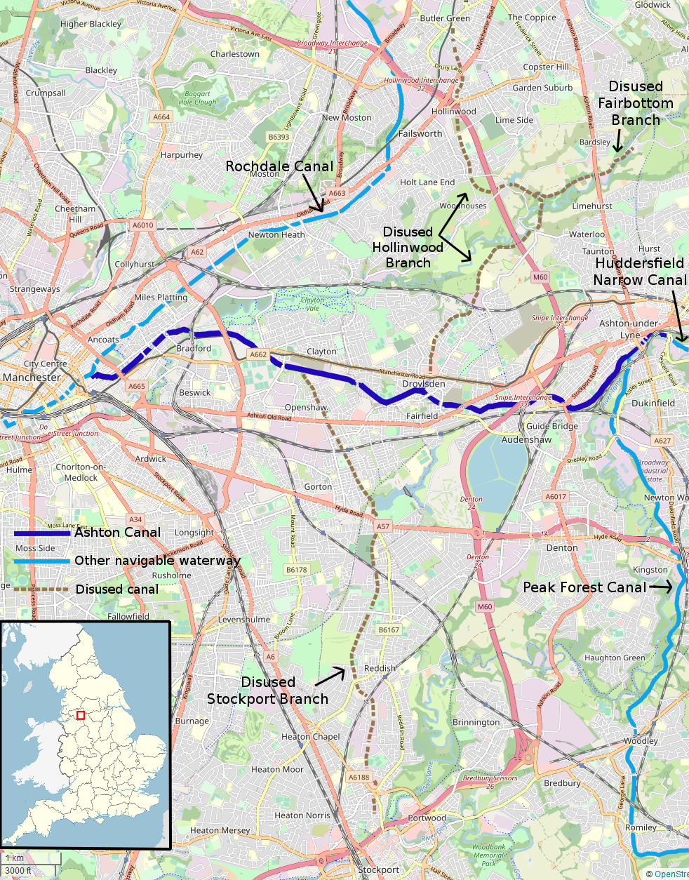
The Ashton Canal is a canal in Greater Manchester, England, linking Manchester with Ashton-under-Lyne. Route The Ashton leaves the Rochdale Canal at Ducie St. Junction in central Manchester, and climbs for through 18 locks, passing through Ancoats, Holt Town, Bradford, Clayton, Openshaw, Droylsden, Fairfield and Audenshaw to make a head-on junction with the Huddersfield Narrow Canal (formerly the Huddersfield Canal) at Whitelands Basin in the centre of Ashton-under-Lyne. At Bradford, the canal passes by the venue of the 2002 Commonwealth Games. Apart from the Rochdale and Huddersfield Narrow canals, the Ashton Canal only currently connects with one other canal. Just short of Whitelands, at Dukinfield Junction/Portland Basin a short arm crosses the river Tame on the Tame Aqueduct, and makes a head-on junction with the Peak Forest Canal. There used to be four other important connections to branch canals: the Islington Branch Canal in Ancoats; the Stockport Branch Ca ... [...More Info...] [...Related Items...] OR: [Wikipedia] [Google] [Baidu] |
Bridgewater Canal
The Bridgewater Canal connects Runcorn, Manchester and Leigh, Greater Manchester, Leigh, in North West England. It was commissioned by Francis Egerton, 3rd Duke of Bridgewater, to transport coal from his mines in Worsley to Manchester. It was opened in 1761 from Worsley to Manchester, and later extended from Manchester to Runcorn, and then from Worsley to Leigh. The canal is connected to the Manchester Ship Canal via a lock at Cornbrook; to the Rochdale Canal in Manchester; to the Trent and Mersey Canal at Preston Brook, southeast of Runcorn; and to the Leeds and Liverpool Canal at Leigh. It once connected with the River Mersey at Runcorn but has since been cut off by a slip road to the Silver Jubilee Bridge. Following the re-routing of roads to the Silver Jubilee Bridge, the Runcorn Locks Restoration Society campaigns to reinstate the flight of locks. The Bridgewater canal is described as the first great achievement of the canal age, although the Sankey Canal opened earlier. ... [...More Info...] [...Related Items...] OR: [Wikipedia] [Google] [Baidu] |
Rochdale Canal
The Rochdale Canal is in Northern England, between Manchester and Sowerby Bridge, part of the connected system of the canals of Great Britain. Its name refers to the town of Rochdale through which it passes. The Rochdale is a broad canal because its locks are wide enough to allow vessels of width. The canal runs for across the Pennines from the Bridgewater Canal at Castlefield Basin in Manchester to join the Calder and Hebble Navigation at Sowerby Bridge in West Yorkshire. As built, the canal had 92 locks. Whilst the traditional lock numbering has been retained on all restored locks, and on the relocated locks, the canal now has 91. Locks 3 and 4 have been replaced with a single deep lock, Tuel Lane Lock, which is numbered 3/4. History The Rochdale Canal was conceived in 1776, when a group of 48 men from Rochdale raised £237 and commissioned James Brindley to conduct a survey of possible routes between Sowerby Bridge and Manchester. Brindley proposed a route similar to ... [...More Info...] [...Related Items...] OR: [Wikipedia] [Google] [Baidu] |
Milnrow Urban District
Milnrow Urban District was, from 1894 to 1974, a local government district of the administrative county of Lancashire, in northwest England. It covered an area to the east and southeast of the County Borough of Rochdale, and included the town of Milnrow, the village of New Hey, and the Piethorne Valley; Crompton Urban District lay to the south. Milnrow Urban District was created by the Local Government Act 1894, and was for the most part the successor to the township of Butterworth. In 1974, Milnrow Urban District was abolished by the Local Government Act 1972 and its former area transferred to Greater Manchester to form part of the Metropolitan Borough of Rochdale The Metropolitan Borough of Rochdale is a metropolitan borough of Greater Manchester in North West England. It is named after its largest town, Rochdale, The borough covers other outlying towns and villages with a population of 206,500 at the .... References [...More Info...] [...Related Items...] OR: [Wikipedia] [Google] [Baidu] |


_2018.png)


