|
Egypt–Sudan Border
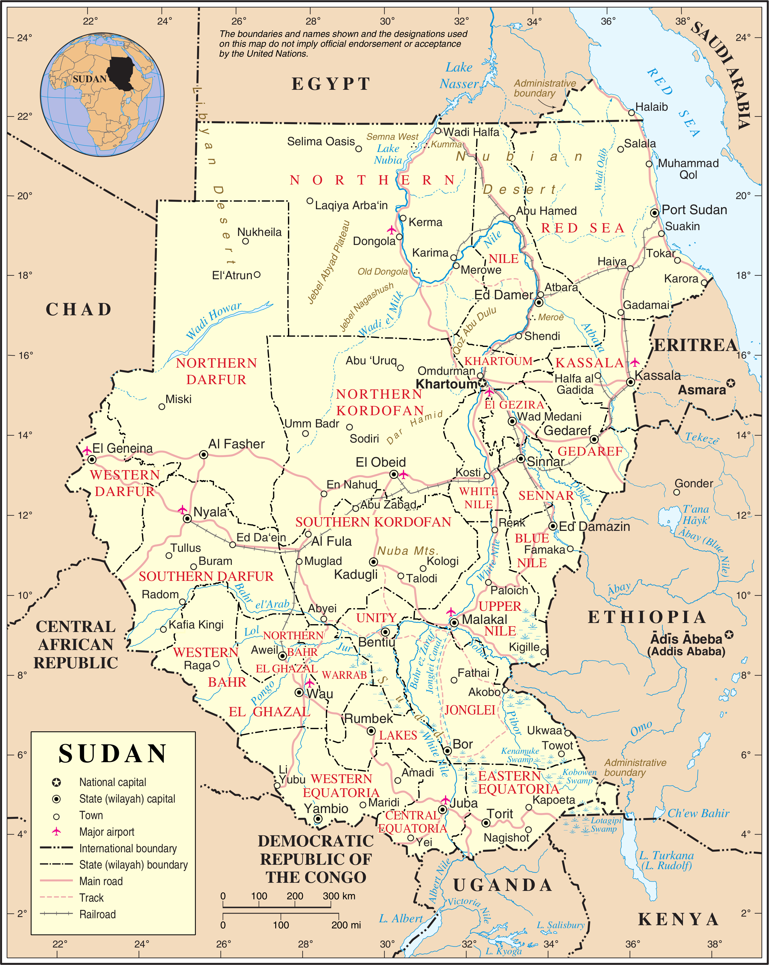
The Egypt– Sudan border ( ar, الحدود السودانية المصرية) is 1,276 km (793 mi) in length and runs from the tripoint with Libya in the west to the Red Sea in the east. The eastern section of the border is subject to a territorial dispute between the two states. Description The border starts in the west at the tripoint with Libya on Gabal El Uweinat and then proceeds eastwards along the 22nd parallel north to Lake Nasser. The border then briefly veers northwards, creating an area known as the ' Wadi Halfa Salient', before resuming its course along the 22nd parallel out to the Red Sea just south of Cape Elba (Ras Hadarba). Sudan maintains that the border diverges about 183 km (114 m) east of the salient, shifting south so as to leave Bir Tawil in Egypt, and then north-east so as to include the Halaib Triangle within Sudan. The boundary traverses a thinly populated region of the Sahara desert and Libyan desert known traditionally as Nubia, with the mai ... [...More Info...] [...Related Items...] OR: [Wikipedia] [Google] [Baidu] |
Wadi Halfa
Wādī Ḥalfā ( ar, وادي حلفا) is a city in the Northern state of Sudan on the shores of Lake Nubia near the border with Egypt. It is the terminus of a rail line from Khartoum and the point where goods are transferred from rail to ferries going down the lake. As of 2007, the city had a population of 15,725. The city is located amidst numerous ancient Nubian antiquities and was the focus of much archaeological work by teams seeking to save artifacts from the flooding caused by the completion of the Aswan Dam. History Archaeological evidence indicates that settlement has been in the area since ancient times, and during the Middle Kingdom period, the Egyptian colony of Buhen across the river existed until the Roman period. The modern town of Wadi Halfa was founded in the 19th century, when it became a port on the Nile for steamers from Aswan, such as the ''Nubia''. During the Turko-Egyptian conquest of 1820, Wadi Halfa was used as a stopping point for troops headed so ... [...More Info...] [...Related Items...] OR: [Wikipedia] [Google] [Baidu] |
Selima Oasis
Selima Oasis is an oasis in the Sudan located west of the Third Cataract of the Nile and the ancient site of Amara West. It lies along the Darb al-Arbaʿīn (Forty Days' Road), a desert track linking Kordofan with Egypt. Just to the north of Selima, the track splits into a northern route going to Kharga Oasis and a northwestern route going to Dunqul Oasis.Richard Lobban, ''Historical Dictionary of Ancient and Medieval Nubia'' (Scarecrow Press, 2004), p. 347. Geography Selima lies at the base of an escarpment of Jurassic and Cretaceous rock. Around 8300 BC, a freshwater lake formed over the site with depths of . The surrounding vegetation was savannah at the time. The remains of lacustrine fauna and of Palaeolithic artefacts have been recovered from the site. Around 4300, it transitioned to a saltwater ''sabkha'' and by 2700 it had dried up. Today it lies over the Nubian Sandstone Aquifer System.Friederike Jesse, Coralie Gradel and Franck Derrien"Archaeology at Selima Oasis, Nor ... [...More Info...] [...Related Items...] OR: [Wikipedia] [Google] [Baidu] |
Faras
Faras (formerly grc, Παχώρας, ''Pakhôras''; la, Pachoras; Old Nubian: Ⲡⲁⲭⲱⲣⲁⲥ, ''Pakhoras'') was a major city in Lower Nubia. The site of the city, on the border between modern Egypt and Sudan at Wadi Halfa Salient, was flooded by Lake Nasser in the 1960s and is now permanently underwater. Before this flooding, extensive archaeological work was conducted by a Polish archaeological team led by professor Kazimierz Michałowski. History Dating back to the A-Group period, the town was a major centre during the Meroitic period, and was the site of a major temple. During the period of ancient Egyptian control over Nubia, Faras became an Egyptian administrative centre and, located upriver from Abu Simbel, Egyptian cultural influences were prominent. The city reached its height during the Christian period of Nubia, when Faras was the capital of the ''basiliskos'' Silko of Nobadia. When Nobatia was absorbed into Makuria, it remained the most prominent center ... [...More Info...] [...Related Items...] OR: [Wikipedia] [Google] [Baidu] |
Shalateen
Shalateen ( ar, شلاتين ' ; also spelled Shalatin and Shalatayn) is the biggest town in the Halaib Triangle, a disputed territory claimed by both Egypt and the Sudan. It is located south of Hurghada and is controlled as the administrative center ('' markaz'') of all Egyptian territory up to the border between Egypt and Sudan, including the villages of: * Abu Ramad, to the southeast; * Halaib, to the southeast; * Ras Hadarba to the southeast. Ras Hadarba or Cape Hadarba lies on the shores of the Red Sea to the southeast of the city of Halayib and to the east of mount Hadarba from which it takes its name. The village of Ras Hadarba lies just north of the borders between Egypt and the Sudan which run along the 22 degree north parallel of latitude; * Marsa Hameera, to the north; and * Abrak, to the west. The first three of the above towns (Abu Ramad, Halayib and Ras Hadarba) are located within the disputed Hala'ib Triangle. History Egyptian ministries and authoritie ... [...More Info...] [...Related Items...] OR: [Wikipedia] [Google] [Baidu] |
Terra Nullius
''Terra nullius'' (, plural ''terrae nullius'') is a Latin expression meaning " nobody's land". It was a principle sometimes used in international law to justify claims that territory may be acquired by a state's occupation of it. : : : : : : There are currently three territories claimed to be ''terra nullius'', two of which caused by border disputes between sovereign states, and one caused by no sovereign state claiming the land. Doctrine In international law, ''terra nullius'' is territory which belongs to no state. Sovereignty over territory which is ''terra nullius'' can be acquired by any state by occupation. According to Oppenheimer, “‘The only territory which can be the object of occupation is that which does not already belong to another state, whether it is uninhabited, or inhabited by persons whose community is not considered to be a state; for individuals may live on as territory without forming themselves into a state proper exercising sovereignt ... [...More Info...] [...Related Items...] OR: [Wikipedia] [Google] [Baidu] |
Port Sudan
Port Sudan ( ar, بور سودان, Būr Sūdān) is a port city in eastern Sudan, and the capital of the state of Red Sea. , it has 489,725 residents. Located on the Red Sea, Port Sudan is recognized as Sudan's main seaport and the source of 90% of the country's international trade. History Port Sudan was built between 1905 and 1909 by the administration of Anglo-Egyptian Sudan to replace Suakin. An oil pipeline was built between the port and Khartoum in 1977. In 2009, Israel allegedly used naval commandos to attack Iranian arms ships at Port Sudan as part of Operation Birds of Prey. In 2020, Russian president Vladimir Putin announced that the Russian Navy would begin construction on a base with capacity for 300 personnel and four warships in Port Sudan. The facility would prove Russia with a naval base in the nation for at least 25 years. The plan was ultimately suspended, though Sudanese leadership indicated that it is possible for the construction to go forward in the fu ... [...More Info...] [...Related Items...] OR: [Wikipedia] [Google] [Baidu] |
Khartoum
Khartoum or Khartum ( ; ar, الخرطوم, Al-Khurṭūm, din, Kaartuɔ̈m) is the capital of Sudan. With a population of 5,274,321, its metropolitan area is the largest in Sudan. It is located at the confluence of the White Nile, flowing north from Lake Victoria, and the Blue Nile, flowing west from Lake Tana in Ethiopia. The place where the two Niles meet is known as ''al-Mogran'' or ''al-Muqran'' (; English: "The Confluence"). From there, the Nile continues north towards Egypt and the Mediterranean Sea. Divided by these two parts of the Nile, Khartoum is a tripartite metropolis with an estimated population of over five million people, consisting of Khartoum proper, and linked by bridges to Khartoum North ( ) and Omdurman ( ) to the west. Khartoum was founded in 1821 as part of Egypt, north of the ancient city of Soba. While the United Kingdom exerted power over Egypt, it left administration of the Sudan to it until Mahdist forces took over Khartoum. The British atte ... [...More Info...] [...Related Items...] OR: [Wikipedia] [Google] [Baidu] |
Anglo-Egyptian Sudan
Anglo-Egyptian Sudan ( ar, السودان الإنجليزي المصري ') was a condominium of the United Kingdom and Egypt in the Sudans region of northern Africa between 1899 and 1956, corresponding mostly to the territory of present-day Sudan and South Sudan. Legally, sovereignty and administration were shared between both Egypt and the United Kingdom, but in practice the structure of the condominium ensured effective British control over Sudan, with Egypt having limited, local power influence in reality. In the mean time, Egypt itself fell under increasing British influence. Following the Egyptian Revolution of 1952, Egypt pushed for an end to the condominium, and the independence of Sudan. By agreement between Egypt and the United Kingdom in 1953, Sudan was granted independence as the Republic of the Sudan on 1 January 1956. In 2011, the south of Sudan itself became independent as the Republic of South Sudan. In the 19th century, whilst nominally a vassal state of the ... [...More Info...] [...Related Items...] OR: [Wikipedia] [Google] [Baidu] |
Mahdist State
The Mahdist State, also known as Mahdist Sudan or the Sudanese Mahdiyya, was a state based on a religious and political movement launched in 1881 by Muhammad Ahmad bin Abdullah (later Muhammad al-Mahdi) against the Khedivate of Egypt, which had ruled the Sudan since 1821. After four years of struggle, the Mahdist rebels overthrew the Ottoman-Egyptian administration and established their own "Islamic and national" government with its capital in Omdurman. Thus, from 1885 the Mahdist government maintained sovereignty and control over the Sudanese territories until its existence was terminated by the Anglo-Egyptian forces in 1898. Mohammed Ahmed al-Mahdi enlisted the people of Sudan in what he declared a jihad against the administration that was based in Khartoum, which was dominated by Egyptians and Turks. The Khartoum government initially dismissed the Mahdi's revolution; he defeated two expeditions sent to capture him in the course of a year. The Mahdi's power increased, and his ... [...More Info...] [...Related Items...] OR: [Wikipedia] [Google] [Baidu] |
Second Egyptian-Ottoman War
The second (symbol: s) is the unit of time in the International System of Units (SI), historically defined as of a day – this factor derived from the division of the day first into 24 hours, then to 60 minutes and finally to 60 seconds each (24 × 60 × 60 = 86400). The current and formal definition in the International System of Units ( SI) is more precise:The second ..is defined by taking the fixed numerical value of the caesium frequency, Δ''ν''Cs, the unperturbed ground-state hyperfine transition frequency of the caesium 133 atom, to be when expressed in the unit Hz, which is equal to s−1. This current definition was adopted in 1967 when it became feasible to define the second based on fundamental properties of nature with caesium clocks. Because the speed of Earth's rotation varies and is slowing ever so slightly, a leap second is added at irregular intervals to civil time to keep clocks in sync with Earth's rotation. Uses Analog clocks and watches often have ... [...More Info...] [...Related Items...] OR: [Wikipedia] [Google] [Baidu] |


.jpg)


