|
Eskişehir Province
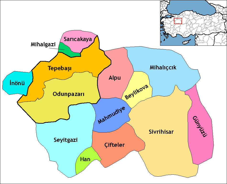
Eskişehir Province ( tr, ) is a province in northwestern Turkey. Its adjacent provinces are Bilecik to the northwest, Kütahya to the west, Afyon to the southwest, Konya to the south, Ankara to the east, and Bolu to the north. The provincial capital is Eskişehir. Most of the province is laid down in Central Anatolia Region. Northern parts of Mihalıççık district and ones of Mihalgazi and Sarıcakaya are located in the Black Sea Region and one of them belong to the Aegean Region. Eskişehir is an old, culturally developed province of Turkey. It has a population of 844,842. Its urban population is 734,837. Eskişehir has 2 universities, Eskişehir Osmangazi University and Anadolu University, which is the largest university in Turkey and which has some branch offices in Europe. Districts Eskişehir province is divided into 14 districts, two of which are included in the greater municipality of Eskişehir (shown in boldface letters). * Odunpazarı * Tepebaşı * Alpu * B ... [...More Info...] [...Related Items...] OR: [Wikipedia] [Google] [Baidu] |
Provinces Of Turkey
Turkey is divided into 81 provinces ( tr, il). Each province is divided into a number of districts (). Each provincial government is seated in the central district (). For non- metropolitan municipality designated provinces, the central district bears the name of the province (e.g. the city/district of Rize is the central district of Rize Province). Each province is administered by an appointed governor () from the Ministry of the Interior. List of provinces Below is a list of the 81 provinces of Turkey, sorted according to their license plate codes. Initially, the order of the codes matched the alphabetical order of the province names. After Zonguldak (code 67), the ordering is not alphabetical, but in the order of the creation of provinces, as these provinces were created more recently and thus their plate numbers were assigned after the initial set of codes had been assigned. Codes The province's ISO code suffix number, the first two digits of the vehicle reg ... [...More Info...] [...Related Items...] OR: [Wikipedia] [Google] [Baidu] |
Aegean Region
The Aegean Region () is one of the 7 geographical regions of Turkey. The largest city in the region is İzmir. Other big cities are Manisa, Aydın, Denizli, Muğla, Afyonkarahisar and Kütahya. Located in western Turkey, it is bordered by the Aegean Sea to the west, the Marmara Region to the north, the Central Anatolia Region to the east, and the Mediterranean Region to the south. Among the four coastal regions, the Aegean Region has the longest coastline. Subdivision *Aegean Section ( tr, Ege Bölümü) **Edremit Area ( tr, Edremit Yöresi) **Bakırçay Area ( tr, Bakırçay Yöresi) **Gediz Area ( tr, Gediz Yöresi) **İzmir Area ( tr, İzmir Yöresi) **Küçük Menderes Area ( tr, Küçük Menderes Yöresi) **Büyük Menderes Area ( tr, Büyük Menderes Yöresi) **Menteşe Area ( tr, Menteşe Yöresi) * Inner Western Anatolia Section ( tr, İç Batı Anadolu Bölümü) Ecoregions The ecoregions of this region are all Terrestrial, more specifically Palear ... [...More Info...] [...Related Items...] OR: [Wikipedia] [Google] [Baidu] |
İnönü, Eskişehir
İnönü is a town and district of Eskişehir Province in the Central Anatolia region of Turkey. According to 2009 census, population of the district is 7,228 of which 3,980 live in the town of İnönü. The district covers an area of , and the average elevation is . History During the western front (also known as the Greco-Turkish War (1919–22) of the Turkish War of Independence in 1921, the First and Second Battles of İnönü took place near the town between the Turkish and the Greek forces. The battles were named after the town, and İsmet İnönü, the Turkish commanding officer during the battles and future President and Prime Minister of Turkey, was given his surname in honor of his services during the battles. Before it became a district in 1987, İnönü belonged to Söğüt district of Bilecik Province in 1922. Afterwards, it became part of Bozüyük district in 1926 and central district of Eskişehir Province in 1963. İnönü was a township A township is a kind ... [...More Info...] [...Related Items...] OR: [Wikipedia] [Google] [Baidu] |
Han, Eskişehir
Han, formerly Hanköy and Hüsrevpaşa, is a town and district of Eskişehir Province in the Central Anatolia region of Turkey Turkey ( tr, Türkiye ), officially the Republic of Türkiye ( tr, Türkiye Cumhuriyeti, links=no ), is a list of transcontinental countries, transcontinental country located mainly on the Anatolia, Anatolian Peninsula in Western Asia, with .... According to a 2010 census, population of the district is 2,165 of which 1,057 live in the town of Han. The district covers an area of , and the town lies at an average elevation of . Notes References * * * External links District governor's official website Map of Han district Towns in Turkey Populated places in Eskişehir Province Districts of Eskişehir Province {{Eskişehir-geo-stub ... [...More Info...] [...Related Items...] OR: [Wikipedia] [Google] [Baidu] |
Günyüzü
Günyüzü is a municipality and district of Eskişehir Province, Turkey. Its area is 828 km2, and its population is 5,155 (2022). Its elevation is . Günyüzü became a bucak (subdistrict) in 1932 and gained the status of a district in 1990. It was in constant interaction with Sivrihisar during the Seljuk and Ottoman periods. It was the scene of important conflicts during the War of Independence and the historical richness of the region became more evident with the excavations. Places of interest Ruins of the Byzantine shrine St Michael at Germia are located in the village of Gümüşkonak, formerly known as Yörme, 8 km south of Günyüzü. Composition There are 22 neighbourhoods A neighbourhood (British English, Irish English, Australian English and Canadian English) or neighborhood (American English; see spelling differences) is a geographically localised community within a larger city, town, suburb or rural ar ... in Günyüzü District: [...More Info...] [...Related Items...] OR: [Wikipedia] [Google] [Baidu] |
Çifteler
Çifteler is a town and district of Eskişehir Province in the Central Anatolia region of Turkey. According to 2000 census, population of the district is 16,716 of which 11,872 live in the town of Çifteler. The district covers an area of , and the average elevation is . Notable natives * Abdil Ceylan Abdil ( ar, عبد ال) is another English form for the Arabic word "Abd-Al", "Abd-El", "Abd-ul" which means ''Servant of''. Abdil is also similar to " Abdeel" ("Servant of God"), which is also cognate to the popular Arabic and Muslim M ... (born 1983), Olympic long-distance runner * Gurer Aykal (born 1942), Conductor Notes References * * * External links Eskişehir governor's official website *Map of Çifteler district Towns in Turkey Populated places in Eskişehir Province Districts of Eskişehir Province {{Eskişehir-geo-stub ... [...More Info...] [...Related Items...] OR: [Wikipedia] [Google] [Baidu] |
Beylikova
Beylikova, formerly Beylikahır, is a town and district of Eskişehir Province in the Central Anatolia region of Turkey Turkey ( tr, Türkiye ), officially the Republic of Türkiye ( tr, Türkiye Cumhuriyeti, links=no ), is a list of transcontinental countries, transcontinental country located mainly on the Anatolia, Anatolian Peninsula in Western Asia, with .... According to 2010 census, population of the district is 6,562 of which 3,157 live in the town of Beylikova. The district covers an area of , and the town lies at an average elevation of . Notes References * * * External links Eskişehir governor's official website *Map of Beylikova districtLocal news website Towns in Turkey Populated places in Eskişehir Province Districts of Eskişehir Province {{Eskişehir-geo-stub ... [...More Info...] [...Related Items...] OR: [Wikipedia] [Google] [Baidu] |
Alpu
Alpu, also Alpıköy, is a town and district of Eskişehir Province in the Central Anatolia region of Turkey Turkey ( tr, Türkiye ), officially the Republic of Türkiye ( tr, Türkiye Cumhuriyeti, links=no ), is a list of transcontinental countries, transcontinental country located mainly on the Anatolia, Anatolian Peninsula in Western Asia, with .... According to 2010 census, population of the district is 12,768 of which 5,126 live in the town of Alpu. The district covers an area of , and the town lies at an average elevation of . Notes References * * External links District municipality's official website Map of Alpu district Towns in Turkey Populated places in Eskişehir Province {{Eskişehir-geo-stub ... [...More Info...] [...Related Items...] OR: [Wikipedia] [Google] [Baidu] |
Tepebaşı, Eskişehir
Tepebaşı is a municipality and district governorate in Greater Eskişehir, Turkey. Eskişehir is one of 30 metropolitan centers in Turkey with more than one municipality within city borders. In Eskişehir there are two second-level municipalities in addition to Greater Eskişehir ( tr, büyükşehir) municipality. The Mayor of Tepebaşı is Ahmet Ataç. Geography Tepebaşı at is a part of Greater Eskişehir. It lies to the north of Porsuk River which flows through the center of Eskişehir. The population of Tepebaşı was 298,894 which is 44% of the population of Greater Eskişehir.Statistical Institute The total population of the district (which includes the rural area) was 296,704 as of 2012. History Up to 1993 Tepebaşı was a part of Eskişeh ...[...More Info...] [...Related Items...] OR: [Wikipedia] [Google] [Baidu] |
Odunpazarı
Odunpazarı (literally "firewood market" in Turkish) is a historic district of Eskişehir Province in the Central Anatolia region of Turkey. Odunpazarı is one of the central districts of Eskişehir along with the district of Tepebaşı. Historic buildings *Alaeddin Mosque Aladdin ( ar, علاء الدين, commonly ) (various spellings and transliterations) is a male given name which means "nobility of faith" or "nobility of creed/religion". It is one of a large class of names ending with ad-Din. The name may refer ... * Kurşunlu Mosque and Complex Museums in Odunpazarı * Eskişehir Meerschaum Museum * Museum of Independence, Eskişehir * Museum of Modern Glass Art, Eskişehir * Tayfun Talipoğlu Typewriter Museum * Yılmaz Büyükerşen Wax Museum References External links *Eskişehir governor's official website*District municipality's official websiteMiscellaneous images of Odunpazarı, Eskişehir Populated places in Eskişehir Province Districts of Eski ... [...More Info...] [...Related Items...] OR: [Wikipedia] [Google] [Baidu] |


