|
Emperor William Monument (Porta Westfalica)
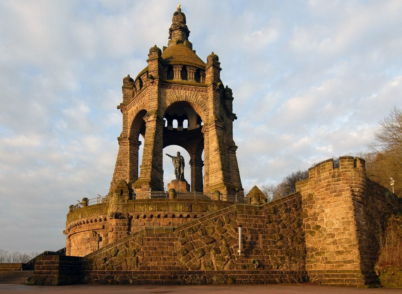
The Emperor William Monument (german: Kaiser-Wilhelm-Denkmal), near the town of Porta Westfalica in the North Rhine-Westphalian county of Minden-Lübbecke, is a colossal monument above the Weser gorge of Porta Westfalica, the "Gateway to Westphalia". It was erected to honour the first German Emperor, William I (1797–1888), by the then Prussian Province of Westphalia between 1892 and 1896Information board with the titl''Emperor William Monument''at the northern approach to the monument at commons.wikimedia.org and emerged against the background of a rising German national identity. The monument, which is around high, is classified as one of Germany's national monuments. The architect of this prominent monument was Bruno Schmitz and the sculptor was Kaspar von Zumbusch. Since 2008, the monument has formed part of the Road of Monuments. As a result of its dominant geographical site, it is the most important landmark of the town of Porta Westfalica and of northern East Westphalia ... [...More Info...] [...Related Items...] OR: [Wikipedia] [Google] [Baidu] |
Kaiser Wilhelm PW
''Kaiser'' is the German word for "emperor" (female Kaiserin). In general, the German title in principle applies to rulers anywhere in the world above the rank of king (''König''). In English, the (untranslated) word ''Kaiser'' is mainly applied to the emperors of the unified German Empire (1871–1918) and the emperors of the Austrian Empire (1804–1918). During the First World War, anti-German sentiment was at its zenith; the term ''Kaiser''—especially as applied to Wilhelm II, German Emperor—thus gained considerable negative connotations in English-speaking countries. Especially in Central Europe, between northern Italy and southern Poland, between western Austria and western Ukraine and in Bavaria, Emperor Franz Joseph I is still associated with "Der Kaiser (the emperor)" today. As a result of his long reign from 1848 to 1916 and the associated Golden Age before the First World War, this title often has still a very high historical respect in this geographical area. ... [...More Info...] [...Related Items...] OR: [Wikipedia] [Google] [Baidu] |
East Westphalia
Ostwestfalen-Lippe (, literally ''East(ern) Westphalia-Lippe'', abbreviation OWL) is the eastern region of the German state of North Rhine-Westphalia, congruent with the administrative region of Detmold and containing the eastern part of Westphalia, joined with the Lippe region. The region has a population of about two million inhabitants. The major cities are Bielefeld, Paderborn, Gütersloh, Minden, Detmold, and Herford. The highest hill of Ostwestfalen-Lippe is the Totenkopf (498 m). Some major globally operating companies are headquartered in the region, for example Bertelsmann, Miele, Dr. Oetker, Melitta, Gerry Weber, DMG Mori Aktiengesellschaft, Hörmann, Schüco, Wincor Nixdorf, Phoenix Contact, HEGLA and Claas. In 2012 OWL became Germans BMBF Leading Edge Technology Cluster for intelligent Technical Systems (it's OWL [...More Info...] [...Related Items...] OR: [Wikipedia] [Google] [Baidu] |
Caspar Von Zumbusch
Kaspar lemens EduardZumbusch (23 November 1830 – 27 September 1915), as of 1888 Ritter von Zumbusch (a nobiliary particle), was a German sculptor, born at Herzebrock, Westphalia, who became a pre-eminent sculptor of neo-Baroque monuments in Vienna. He went at the age of eighteen to study in Munich. at first unsuccessfully at the Academy and then Polytechische Schule under Johann Halbig. He continued his studies in Rome. He won the competition in 1866 for a monument to Maximilian II of Bavaria, for the Maximilianstraße, Munich (unveiled 1875). In 1873 he was called to Vienna as professor in the academy, a post he held until he was made Professor Emeritus in 1901. His most important works are a statue of Count Rumford, Munich; and the monuments to Prince August of Prussia (Bellevue Park, Berlin), Beethoven (1873-1880, Vienna), Maria Theresa (1887, Vienna), and to Emperor William I (1896, Wittekindsberg, Westphalia). Also in Vienna are his monuments to Count Radetzky (1891) and ... [...More Info...] [...Related Items...] OR: [Wikipedia] [Google] [Baidu] |
Westphalian Gate
Weser watershed The Porta Westfalica, also known as the Westphalian Gap, is a gorge and water gap where the Weser river breaks through the passage between the mountain chains of the Wiehen Hills in the west and the Weser Hills (part of the Weser Uplands) in the east. It is located in the district of Minden-Lübbecke in North Rhine-Westphalia, Germany. Since 1973, Porta Westfalica is also the name of a town, which was established by merging fifteen villages surrounding the gorge. Since 2006, it is a national geotope. retrieved on 27. January 2011 The name "Porta Westfalica" is a term that means "Gate to |
Bundesstraße 61
''Bundesstraße'' (German for "federal highway"), abbreviated ''B'', is the denotation for German and Austrian national highways. Germany Germany's ''Bundesstraßen'' network has a total length of about 40,000 km. German ''Bundesstraßen'' are labelled with rectangular yellow signs with black numerals, as opposed to the white-on-blue markers of the ''Autobahn'' controlled-access highways. ''Bundesstraßen'', like autobahns, are maintained by the federal agency of the Transport Ministry. In the German highway system they rank below autobahns, but above the ''Landesstraßen'' and ''Kreisstraßen'' maintained by the federal states and the districts respectively. The numbering was implemented by law in 1932 and has overall been retained up to today, except for those roads located in the former eastern territories of Germany. One distinguishing characteristic between German ''Bundesstraßen'' and ''Autobahnen'' is that there usually is a general 100 km/h (62 mph) s ... [...More Info...] [...Related Items...] OR: [Wikipedia] [Google] [Baidu] |
Barkhausen (Porta Westfalica)
Barkhausen is a German surname. Notable people with the surname include: * David N. Barkhausen (born 1950), American politician and lawyer * Heinrich Barkhausen (1881–1956), German physicist born at Bremen * Louis Henry Barkhausen (1877–1962), stamp collector of Chicago, Illinois See also * Barkhausen effect, the discontinuous change of magnetization in a ferromagnetic material when the applied magnetic field is changed * Barkhausen stability criterion, in electronic circuits * Barkhausen–Kurz tube The Barkhausen–Kurz tube, also called the retarding-field tube, reflex triode, B–K oscillator, and Barkhausen oscillator was a high frequency vacuum tube electronic oscillator invented in 1920 by German physicists Heinrich Georg Barkhau ..., electronic vacuum tube oscillator {{surname German-language surnames ... [...More Info...] [...Related Items...] OR: [Wikipedia] [Google] [Baidu] |
North German Plain
The North German Plain or Northern Lowland (german: Norddeutsches Tiefland) is one of the major geographical regions of Germany. It is the German part of the North European Plain. The region is bounded by the coasts of the North Sea and the Baltic Sea to the north, Germany's Central Uplands (''die Mittelgebirge'') to the south, by the Netherlands to the west and Poland to the east. In the west, the southern boundary of the North German Plain is formed by the Lower Saxon Hills: specifically the ridge of the Teutoburg Forest, the Wiehen Hills, the Weser Hills and the Lower Saxon Börde, which partly separate it from that area of the Plain known as the Westphalian Lowland. Elements of the Rhenish Massif also act a part of the southern boundary of the plain: the Eifel, Bergisches Land and the Sauerland. In the east the North German Plain spreads out beyond the Harz Mountains and Kyffhäuser further to the south as far as the Central Saxon hill country and the foothills of the Ore M ... [...More Info...] [...Related Items...] OR: [Wikipedia] [Google] [Baidu] |
Central Uplands
The Central UplandsDickinson (1964), p.18 ff. (german: die MittelgebirgeN.B. In German die ''Mittelgebirge'' (plural) refers to the Central Uplands; das ''Mittelgebirge'' refers to a low mountain range or upland region (''Mittel'' = "medium" and ''-gebirge'' = "range").) is one of the three major natural regions of Germany. It stretches east to west across the country. To the north lies the North German Plain or Northern Lowland; to the south, the Alps and the Alpine Foreland. Formation The German Central Uplands, like the Scandinavian and British mountain ranges and the Urals, belong to the oldest mountains of Europe, even if their present-day appearance has only developed relatively recently. In the Carboniferous, i.e. about 350 million years ago, Variscan mountain ranges were formed in central Europe by the uplifting caused by tectonic plate collision. Immediately after their formation the erosion of the mountains began under the influence of exogenous processes during the ... [...More Info...] [...Related Items...] OR: [Wikipedia] [Google] [Baidu] |
Minden
Minden () is a middle-sized town in the very north-east of North Rhine-Westphalia, Germany, the greatest town between Bielefeld and Hanover. It is the capital of the district (''Kreis'') of Minden-Lübbecke, which is part of the region of Detmold. The town extends along both sides of the River Weser, and is crossed by the Mittelland Canal, which is passing the river on the Minden Aqueduct. In the 1,200 years longing time of written history, Minden had functions as diocesan town from 800 AD to the Peace of Westphalia in 1648, as capital of the Prince-Bishopric of Minden as imperial territory since the 12th century, afterwards as capital of the Prussian territory of Minden-Ravensberg until the end of the Holy Roman Empire in 1806, and as capital of the East-Westphalian region from the Congress of Vienna until 1947. Furthermore Minden has been of great military importance with fortifications from the 15th to the late 19th century, and is yet place of a garrison. Minden is locati ... [...More Info...] [...Related Items...] OR: [Wikipedia] [Google] [Baidu] |
Weser Hills
The Weser Hills (''Wesergebirge''), also known in German as the ''Weserkette'' ("Weser Chain"),"Ein anderes Bild als die Bergländer der oberen Weser bieten die ''Weserkette'', das ''Wiehengebirge'' und der ''Teutoburger Wald'', see Christian Degn, et al. (ed.) Seydlitz, 1st Part, ''das deutsche Vaterland, wir und die Welt'', 7th ed., Kiel, Hanover, 1954, p. 50 form a low hill chain, up to , in the Weser Uplands in the German states of North Rhine-Westphalia and Lower Saxony. The thickly wooded Weser ridge is one of the northern outliers of the German Central Uplands on the southern edge of the North German Plain and forms part of the TERRA.vita Nature Park in the west and Weser Uplands Schaumburg-Hameln Nature Park in the east. The Weser Hills are widely known because of Schaumburg Castle, Lower Saxony, Schaumburg Castle which stands on the Nesselberg (c. ) in the Schaumburg district of the town of Rinteln, and is the emblem of Schaumburg Land. Geography The Weser Hills cross ... [...More Info...] [...Related Items...] OR: [Wikipedia] [Google] [Baidu] |
River Weser
The Weser () is a river of Lower Saxony in north-west Germany. It begins at Hannoversch Münden through the confluence of the Werra and Fulda. It passes through the Hanseatic city of Bremen. Its mouth is further north against the ports of Bremerhaven and Nordenham. The latter is on the Butjadingen Peninsula. It then merges into the North Sea via two highly saline, estuarine mouths. It connects to the canal network running east-west across the North German Plain. The river, when combined with the Werra (a dialectal form of "Weser"), is long and thus, the longest river entirely situated within Germany (the Main, however, is the longest if the Weser and Werra are not combined). The Weser itself is long. The Werra rises in Thuringia, the German state south of the main projection (tongue) of Lower Saxony. Etymology "Weser" and "Werra" are the same words in different dialects. The difference reflects the old linguistic border between Central and Low German, passing through Ha ... [...More Info...] [...Related Items...] OR: [Wikipedia] [Google] [Baidu] |


_sculptor.jpg)


