|
Edirne Vilayet
The Vilayet of Adrianople or Vilayet of Edirne ( ota, ولايت ادرنه; ''Vilâyet-i Edirne'') was a first-level administrative division (vilayet) of the Ottoman Empire. This vilayet was split between Turkey and Greece in 1923, culminating in the formation of Western and Eastern Thrace after World War I as part of the Treaty of Lausanne. A small portion of the Vilayet was given to Bulgaria in the Treaty of Bucharest (1913) after the Balkan wars. In the late 19th century it reportedly had an area of .Europe by Éliseé Reclus, page 152 In the east it bordered with the Istanbul Vilayet, the |
Vilayet
A vilayet ( ota, , "province"), also known by #Names, various other names, was a first-order administrative division of the later Ottoman Empire. It was introduced in the Vilayet Law of 21 January 1867, part of the Tanzimat reform movement initiated by the Ottoman Reform Edict of 1856. The Danube Vilayet had been specially formed in 1864 as an experiment under the leading reformer Midhat Pasha. The Vilayet Law expanded its use, but it was not until 1884 that it was applied to all of the empire's provinces. Writing for the ''Encyclopaedia Britannica'' in 1911, Vincent Henry Penalver Caillard claimed that the reform had intended to provide the provinces with greater amounts of local self-government but in fact had the effect of centralizing more power with the sultan of the Ottoman Empire, sultan and Islam in the Ottoman Empire, local Muslims at the expense of other communities. Names The Ottoman Turkish ''vilayet'' () was a loanword linguistic borrowing, borrowed from Arabic lan ... [...More Info...] [...Related Items...] OR: [Wikipedia] [Google] [Baidu] |
Black Sea
The Black Sea is a marginal mediterranean sea of the Atlantic Ocean lying between Europe and Asia, east of the Balkans, south of the East European Plain, west of the Caucasus, and north of Anatolia. It is bounded by Bulgaria, Georgia, Romania, Russia, Turkey, and Ukraine. The Black Sea is supplied by major rivers, principally the Danube, Dnieper, and Don. Consequently, while six countries have a coastline on the sea, its drainage basin includes parts of 24 countries in Europe. The Black Sea covers (not including the Sea of Azov), has a maximum depth of , and a volume of . Most of its coasts ascend rapidly. These rises are the Pontic Mountains to the south, bar the southwest-facing peninsulas, the Caucasus Mountains to the east, and the Crimean Mountains to the mid-north. In the west, the coast is generally small floodplains below foothills such as the Strandzha; Cape Emine, a dwindling of the east end of the Balkan Mountains; and the Dobruja Plateau considerably farth ... [...More Info...] [...Related Items...] OR: [Wikipedia] [Google] [Baidu] |
Dedeağaç
Alexandroupolis ( el, Αλεξανδρούπολη, ), Alexandroupoli, or Alexandrople is a city in Greece and the capital of the Evros regional unit. It is the largest city in Western Thrace and the region of Eastern Macedonia and Thrace. It has 71,601 inhabitants and is an important port and commercial center of northeastern Greece. The city was first settled by the Ottoman Empire in the 19th century and grew into a fishing village, Dedeağaç. In 1873, it became a ''kaza'' and one year later, it was promoted to a ''sanjak''. The city developed into a regional trading center. Later, it became a part of Adrianople Vilayet. During the Russo-Turkish War (1877–1878), it was briefly captured by the Russians. Ottoman rule ended with the First Balkan War, when the city was captured by Bulgaria in 1912. In the Second Balkan War, Greece took the control of the city. With the Treaty of Bucharest (10 August 1913), the city returned back to Bulgaria. With the defeat of Bulgaria in Wor ... [...More Info...] [...Related Items...] OR: [Wikipedia] [Google] [Baidu] |
Gümülcine
Komotini ( el, Κομοτηνή, tr, Gümülcine, bg, Комотини) is a city in the region of East Macedonia and Thrace, northeastern Greece. It is the capital of the Rhodope. It was the administrative centre of the Rhodope-Evros super-prefecture until its abolition in 2010, by the Kallikratis Plan. The city is home to the Democritus University of Thrace, founded in 1973. Komotini is home to a sizeable Turkish speaking Muslim minority. They were excluded from the 1923 population exchange. Komotini has population of65.107 /Https://elstat-outsourcers.statistics.gr/Census2022%20GR.pdf citizens Built at the northern part of the plain bearing the same name, Komotini is one of the main administrative, financial and cultural centers of northeastern Greece and also a major agricultural and breeding center of the area. It is also a significant transport interchange, located 795 km NE of Athens and 281 km NE of Thessaloniki. The presence of the Democritus University of Thr ... [...More Info...] [...Related Items...] OR: [Wikipedia] [Google] [Baidu] |
Enez
Enez is a town and a district of Edirne Province, in Thrace, Turkey. The ancient name of the town was Ainos ( el, Αίνος), Latinised as Aenus. The mayor is Özkan Günenç ( CHP). The population is 10,886 as of 2018. Enez consists of an old town centre, backing on to the Meriç/Evros river forming the border with neighbouring Greece; the harbour and Pırlanta Beach, 3 km southwest across the lagoon; and Altınkum Sahili (Golden Sands Beach), another 2 km south, which has been developed as a resort strip mainly catering for domestic tourists. Despite Enez's proximity to the Greek border there is no crossing point by land here. To cross the border into Greece it is necessary to travel north to İpsala. Location The town is located on the left (eastern) bank of the river Meriç (Greek: Evros, historically the Hebrus) where its estuary broadens to flow into the Gulf of Saros (the ancient Melas Gulf) and so into the Aegean Sea. Enez occupies a ridge of rock surrounded by broad ... [...More Info...] [...Related Items...] OR: [Wikipedia] [Google] [Baidu] |
Dimetoka
Didymoteicho ( el, Διδυμότειχο, Didymóteicho ) is a city located on the eastern edge of the Evros regional unit of Eastern Macedonia and Thrace, in northeastern Greece. It is the seat of the municipality of the same name. The town (pop. 9,263 in 2011) sits on a plain and located south east of Svilengrad, south of Edirne, Turkey and Orestiada, west of Uzunköprü, Turkey, about 20 km north of Soufli and about 90 km north of Alexandroupoli. The municipality of Didymóteicho has a land area of 565.4 km² and a population of 19,493 inhabitants. Name "Didymoteicho" is the modern Greek form of , ''Didymóteichon'', from , ''dídymos'', "twin" and , ''teîchos'', "wall". The name first appears in 591/592, and most resulted from the refortification of the city under Justinian I (see below). The corrupted short form ''Dimotica'' or ''Demotica'' or variants thereof are attested in Western languages since the late 12th century (early forms ''Timoticon'', ''Dim ... [...More Info...] [...Related Items...] OR: [Wikipedia] [Google] [Baidu] |
Çorlu
Çorlu () is a northwestern Turkish city in inland Eastern Thrace that falls under the administration of the Province of Tekirdağ. It is a rapidly growing industrial centre built on flatland located on the motorway Otoyol 3 and off the highway D.100 between Istanbul and Turkey's border with Greece and Bulgaria. The nearest airport is Tekirdağ-Çorlu Airport (TEQ). History Bronze Age relics have been found in various areas of Thrace including Çorlu and by 1000 BC the area was a Phrygian-Greek colony named Tzirallum, Tzirallun, or Tzirallon (Τζίραλλον) . The area was subsequently controlled by the Greeks, Persians, Romans and Byzantines. During Roman and Byzantine times, the town was referred to as Tzouroulos, or Syrallo.Tabula Peutingeriana The spelling "Zorolus" is used for the Latinised form of the name of the episcopal see identified with present-day Çorlu in the Catholic Church's list of titular sees. Some writers have identified the Roman town of Caenophr ... [...More Info...] [...Related Items...] OR: [Wikipedia] [Google] [Baidu] |
İskeçe
Xanthi ( el, Ξάνθη, ''Xánthi'', ) is a city in the region of Western Thrace, northeastern Greece. It is the capital of the Xanthi regional unit of the region of East Macedonia and Thrace. Amphitheatrically built on the foot of Rhodope mountain chain, the city is divided by the Kosynthos River, into the west part, where the old and the modern town are located, and the east part that boasts a rich natural environment. The "Old Town of Xanthi" is known throughout Greece for its distinctive architecture, combining many Byzantine Greek churches with neoclassical mansions of Greek merchants from the 18th and 19th centuries and Ottoman-Era mosques. Other landmarks in Xanthi include the Archaeological Museum of Abdera and the Greek Folk Art Museum. Xanthi is famous throughout Greece (especially Macedonia and Thrace) for its annual spring carnival (Greek: καρναβάλι) which has a significant role in the city's economy. Over 40 cultural associations from around Greece part ... [...More Info...] [...Related Items...] OR: [Wikipedia] [Google] [Baidu] |
Kırklareli
Kırklareli () is a city within Kırklareli Province in the East Thrace, European part of Turkey. Name It is not clearly known when the city was founded, nor under what name. The Byzantine Greeks called it Sarànta Ekklisiès (''Σαράντα Εκκλησιές'', meaning ''forty churches''). In Greek language, modern Greek it is known with the same name, too. In the 14th century this was translated to Turkish language, Turkish and called "''Kırk Kilise''". Following the establishment of the Turkish Republic in 1923, sanjaks became cities and on December 20, 1924, Kırk Kilise's name was changed to ''Kırklareli'', meaning ''The Place of the Forties''. The denomination ''Kırklareli'' was already used years before 1924, for example in the contemporary literature concerning the Balkan Wars of 1912–13. The Bulgarian language, Bulgarian name of the town is Lòzengrad (Лозенград) which means ''Vineyard Town''. (see also its Names of European cities in different languages: I ... [...More Info...] [...Related Items...] OR: [Wikipedia] [Google] [Baidu] |
Gelibolu
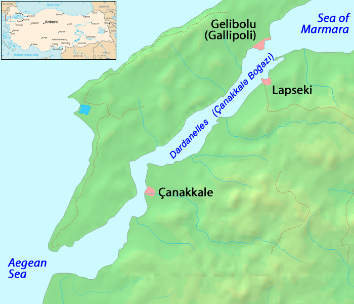
Gelibolu, also known as Gallipoli (from el, Καλλίπολις, ''Kallipolis'', "Beautiful City"), is the name of a town and a district in Çanakkale Province of the Marmara Region, located in Eastern Thrace in the European part of Turkey on the southern shore of the peninsula named after it on the Dardanelles The Dardanelles (; tr, Çanakkale Boğazı, lit=Strait of Çanakkale, el, Δαρδανέλλια, translit=Dardanéllia), also known as the Strait of Gallipoli from the Gallipoli peninsula or from Classical Antiquity as the Hellespont (; ... strait, away from Lapseki on the other shore. History The Macedonia (ancient kingdom), Macedonian city of Callipolis was founded in the 5th century B.C. It has a rich history as a naval base for various rulers. The emperor Justinian I fortified Gallipoli and established important military warehouses for corn and wine there, of which some Byzantine ruins can still be seen. [...More Info...] [...Related Items...] OR: [Wikipedia] [Google] [Baidu] |
Tekirdağ
Tekirdağ (; see also its other names) is a city in Turkey. It is located on the north coast of the Sea of Marmara, in the region of East Thrace. In 2019 the city's population was 204,001. Tekirdağ town is a commercial centre with a harbour for agricultural products (the harbour is being expanded to accommodate a new rail link to the main freight line through Thrace). It is also home to Martas and the BOTAŞ Terminal, both of them important for trade activities in the Marmara Region. The town's best known product remains Tekirdağ rakı although it is also known for its cherries, celebrated with a festival every June. The proximity of the Greek and Bulgarian borders means that there are honorary consulates for both countries in Tekirdağ town. Ferries from Tekirdağ sail to the nearby Marmara Islands during the summer. The nearest airport is Tekirdağ - Çorlu Airport (TEQ) although there are many more flights to Istanbul International Airport (IST). Names and etymology ... [...More Info...] [...Related Items...] OR: [Wikipedia] [Google] [Baidu] |
Aegean Sea
The Aegean Sea ; tr, Ege Denizi (Greek language, Greek: Αιγαίο Πέλαγος: "Egéo Pélagos", Turkish language, Turkish: "Ege Denizi" or "Adalar Denizi") is an elongated embayment of the Mediterranean Sea between Europe and Asia. It is located between the Balkans and Anatolia, and covers an area of some 215,000 square kilometres. In the north, the Aegean is connected to the Marmara Sea and the Black Sea by the straits of the Dardanelles and the Bosphorus. The Aegean Islands are located within the sea and some bound it on its southern periphery, including Crete and Rhodes. The sea reaches a maximum depth of 2,639m to the west of Karpathos. The Thracian Sea and the Sea of Crete are main subdivisions of the Aegean Sea. The Aegean Islands can be divided into several island groups, including the Dodecanese, the Cyclades, the Sporades, the Saronic Islands, Saronic islands and the North Aegean islands, North Aegean Islands, as well as Crete and its surrounding islands. The ... [...More Info...] [...Related Items...] OR: [Wikipedia] [Google] [Baidu] |


.jpg)


