|
Dwyriw
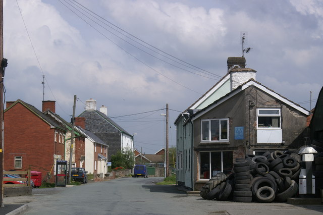
Dwyriw is a community in the county of Powys (previously Montgomeryshire), mid Wales. It is located between two tributaries of the Afon Rhiw, hence the name ("Two Rhiw Rivers"), south-west of Llanfair Caereinion. Historic buildings nearby include Capel Coffa Lewis Evan in Adfa and St. Mary's Church, Llanllugan. The villages within the community include Adfa (the largest settlement), Llanllugan, Cefn Coch and Llanwyddelan. According to the 2011 Census the population of Dwyriw was 571, including 474 adults over 16 years old. The community elects eight community councillors to Dwyriw Community Council, from the wards of Llanwyddelan and Llanllugan. The area formerly had an abbey An abbey is a type of monastery used by members of a religious order under the governance of an abbot or abbess. Abbeys provide a complex of buildings and land for religious activities, work, and housing of Christian monks and nuns. The con .... References Communities in Powys Villa ... [...More Info...] [...Related Items...] OR: [Wikipedia] [Google] [Baidu] |
Powys
Powys (; ) is a Local government in Wales#Principal areas, county and Preserved counties of Wales, preserved county in Wales. It is named after the Kingdom of Powys which was a Welsh succession of states, successor state, petty kingdom and principality that emerged during the Middle Ages following the end of Roman rule in Britain. Geography Powys covers the historic counties of Montgomeryshire and Radnorshire, most of Brecknockshire, and part of Denbighshire (historic), historic Denbighshire. With an area of about , it is now the largest administrative area in Wales by land and area (Dyfed was until 1996 before several Preserved counties of Wales, former counties created by the Local Government Act 1972 were abolished). It is bounded to the north by Gwynedd, Denbighshire and Wrexham County Borough; to the west by Ceredigion and Carmarthenshire; to the east by Shropshire and Herefordshire; and to the south by Rhondda Cynon Taf, Merthyr Tydfil County Borough, Caerphilly County Bor ... [...More Info...] [...Related Items...] OR: [Wikipedia] [Google] [Baidu] |
Adfa, Powys
Adfa is a village in the Welsh county of Powys, in mid Wales. It is in the historic county of Montgomeryshire , HQ= Montgomery , Government= Montgomeryshire County Council (1889–1974)Montgomeryshire District Council (1974–1996) , Origin= , Status= , Start= , End= .... External links Photos of Adfa and surrounding area on geograph Villages in Powys {{Powys-geo-stub ... [...More Info...] [...Related Items...] OR: [Wikipedia] [Google] [Baidu] |
Communities In Powys
A community is a social unit (a group of living things) with commonality such as place, norms, religion, values, customs, or identity. Communities may share a sense of place situated in a given geographical area (e.g. a country, village, town, or neighbourhood) or in virtual space through communication platforms. Durable good relations that extend beyond immediate genealogical ties also define a sense of community, important to their identity, practice, and roles in social institutions such as family, home, work, government, society, or humanity at large. Although communities are usually small relative to personal social ties, "community" may also refer to large group affiliations such as national communities, international communities, and virtual communities. The English-language word "community" derives from the Old French ''comuneté'' (Modern French: ''communauté''), which comes from the Latin ''communitas'' "community", "public spirit" (from Latin ''communis'', "comm ... [...More Info...] [...Related Items...] OR: [Wikipedia] [Google] [Baidu] |
Llanllugan Abbey
Llanllugan Abbey was a monastery of Cistercian nuns, one of only two Cistercian women's monasteries in Wales, located at Llanllugan, Powys, Wales. An early charter to Llanllugan nunnery was issued by Maredudd ap Rhobert, Lord of Cedewain, probably some time in the early thirteenth century. Maredudd's charter provided the nuns with their core estates in the township of Llanllugan between the two streams of the Rhiw. The abbey's other estates include Hydan grange in Castle Caereinion and Cowney in Llangadfan. Llanllugan also received income from appropriated churches, the rectory of Llanfair Caereinion was granted by Bishop Hugh of St Asaph in 1239 and Llanllwchairan by Bishop Anian of St Asaph in 1263. It was founded as a dependency of the Cistercian monks at the Abbey of Strata Marcella. The former monastery church survives as the parish church of Llanllugan. However, the site of the abbey buildings remains uncertain: they might have been in a meadow 200 metres to the south of ... [...More Info...] [...Related Items...] OR: [Wikipedia] [Google] [Baidu] |
2011 UK Census
A census of the population of the United Kingdom is taken every ten years. The 2011 census was held in all countries of the UK on 27 March 2011. It was the first UK census which could be completed online via the Internet. The Office for National Statistics (ONS) is responsible for the census in England and Wales, the General Register Office for Scotland (GROS) is responsible for the census in Scotland, and the Northern Ireland Statistics and Research Agency (NISRA) is responsible for the census in Northern Ireland. The Office for National Statistics is the executive office of the UK Statistics Authority, a non-ministerial department formed in 2008 and which reports directly to Parliament. ONS is the UK Government's single largest statistical producer of independent statistics on the UK's economy and society, used to assist the planning and allocation of resources, policy-making and decision-making. ONS designs, manages and runs the census in England and Wales. In its capacity as t ... [...More Info...] [...Related Items...] OR: [Wikipedia] [Google] [Baidu] |
Cefn Coch
Cefn Coch is a small village or hamlet near Llanfair Caereinion in Mid Wales, located at . In 2012, the village was chosen as the site for a substation serving several wind farms Wind is the natural movement of air or other gases relative to a planet's surface. Winds occur on a range of scales, from thunderstorm flows lasting tens of minutes, to local breezes generated by heating of land surfaces and lasting a few h ... in the area, causing public outcry. References Villages in Powys {{Wales-geo-stub ... [...More Info...] [...Related Items...] OR: [Wikipedia] [Google] [Baidu] |
Llanfair Caereinion
Llanfair Caereinion is a market town and community in Montgomeryshire, Powys, Wales upon the River Banwy (also known as the River Einion), around 8 miles west of Welshpool. In 2011 the ward had a population of 1,810; the town itself had a population of 1,055 according to Nomis. History Its name is a combination of Welsh ' "church" + ' "Mary" and ' "fort" + ', a personal name, meaning "the church of Mary tthe fort of Einion". The town is built upon the site of an old Roman fort. The site of the Battle of Maes Moydog (1295) is nearby. In 1758 the town was almost completely wiped out by a major fire. Geography The town is close to Welshpool and not far away are the towns of Machynlleth and Llanfyllin. The town acts as a major centre for a lot of scattered hamlets and villages around the community. The electorate of the community only places it fourteenth in the rank of the county's eighteen towns. Llanfair Caereinion is classified as an area centre in the Powys Unitary Develo ... [...More Info...] [...Related Items...] OR: [Wikipedia] [Google] [Baidu] |
Newtown, Powys
Newtown ( cy, Y Drenewydd) is a town in Powys, Wales. It lies on the River Severn in the community of Newtown and Llanllwchaiarn, within the historic boundaries of Montgomeryshire. It was designated a new town in 1967 and saw population growth as firms settled, changing its market town character. Its 2001 population of 10,780 rose to 11,357 at the 2011 census. Newtown was the birthplace of Robert Owen in 1771, whose house stood on the present site of the HSBC Bank.BiographRetrieved 15 September 2018./ref> The town has a theatre, Theatr Hafren,Theatre sitRetrieved 15 September 2018./ref> and a public gallery, Oriel Davies, displaying contemporary arts and crafts.Gallery sitRetrieved 15 September 2018./ref> It is the largest town in Powys and Mid Wales. Etymology Both the English and Welsh names for the town mean "new town", the Welsh version with addition of the definite article. History At the end of the 13th century, Edward I commissioned Roger de Montgomerie to construc ... [...More Info...] [...Related Items...] OR: [Wikipedia] [Google] [Baidu] |
Afon Rhiw
This is a list of rivers of Wales, organised geographically. It is taken anti-clockwise from the Dee Estuary to the M48 Bridge that separates the estuary of the River Wye from the River Severn. Tributaries are listed down the page in an upstream direction, starting with those closest to the sea. The main stem (or principal) river of a catchment is given, left-bank tributaries are indicated by (L), and right-bank tributaries by (R). Note that, in general usage, the 'left (or right) bank of a river' refers to the left (or right) hand bank as seen when looking downstream. Where a named river is formed by the confluence of two differently named rivers, these are labelled as (Ls) and (Rs) for the left and right forks. A prime example is the formation of the River Taff from the Taf Fawr and the Taf Fechan at Cefn Coed-y-cymmer. The list includes more or less every watercourse named on Ordnance Survey mapping and thus many of the main rivers of Wales (as defined by Natural Resources ... [...More Info...] [...Related Items...] OR: [Wikipedia] [Google] [Baidu] |
Wales
Wales ( cy, Cymru ) is a Countries of the United Kingdom, country that is part of the United Kingdom. It is bordered by England to the Wales–England border, east, the Irish Sea to the north and west, the Celtic Sea to the south west and the Bristol Channel to the south. It had a population in 2021 of 3,107,500 and has a total area of . Wales has over of coastline and is largely mountainous with its higher peaks in the north and central areas, including Snowdon (), its highest summit. The country lies within the Temperateness, north temperate zone and has a changeable, maritime climate. The capital and largest city is Cardiff. Welsh national identity emerged among the Celtic Britons after the Roman withdrawal from Britain in the 5th century, and Wales was formed as a Kingdom of Wales, kingdom under Gruffydd ap Llywelyn in 1055. Wales is regarded as one of the Celtic nations. The Conquest of Wales by Edward I, conquest of Wales by Edward I of England was completed by 1283, th ... [...More Info...] [...Related Items...] OR: [Wikipedia] [Google] [Baidu] |


.jpg)
