|
Dryfesdale
Dryfesdale ( ) is a civil parish of the council area of Dumfries and Galloway, Scotland. It is part of the county of Dumfriesshire. Overview The parish church of Dryfesdale, located in the centre of Lockerbie, was dedicated to St Cuthbert. In 1116 it belonged to the See of Galloway. The civil parish of Dryfesdale includes the town of Lockerbie which has apparently existed since at least the days of Viking influence in this part of Scotland in the period around AD 900. The name means ''Lockard's Farm'' in Old Norse. The presence of the remains of a Roman camp a mile to the west of the town suggests its origins may be even earlier. Lockerbie first entered recorded history, as ''Lokardebi'', in 1306. Strong old towers were at Netherplace, Old Walls, Kirkton Mains, Myrehead and Daltonhook. Remains of eight camps, some square or Roman, others circular or Caledonian, occur in different places, chiefly on hilltops. Two of them, Roman and Caledonian, confront each other on hill ... [...More Info...] [...Related Items...] OR: [Wikipedia] [Google] [Baidu] |
Pan Am Flight 103
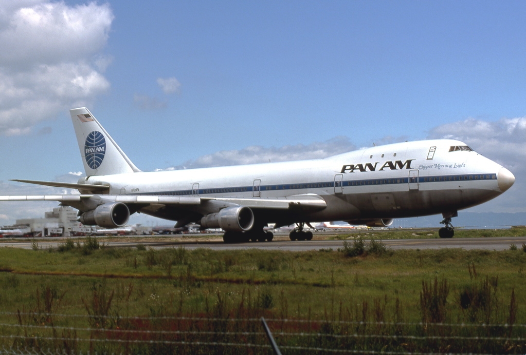
Pan Am Flight 103 was a regularly scheduled Pan Am transatlantic flight from Frankfurt to Detroit via a stopover in London and another in New York City. The transatlantic leg of the route was operated by ''Clipper Maid of the Seas'', a Boeing 747-121 registered N739PA. Shortly after 19:00 on 21 December 1988, while the aircraft was in flight over the Scottish town of Lockerbie, it was destroyed by a bomb that had been planted on board, killing all 243 passengers and 16 crew in what became known as the Lockerbie bombing. Large sections of the aircraft crashed in a residential street in Lockerbie, killing 11 residents. With a total of 270 fatalities, it is the deadliest terrorist attack in the history of the United Kingdom, as well as its deadliest aviation disaster. Following a three-year joint investigation by Dumfries and Galloway Constabulary and the US Federal Bureau of Investigation (FBI), arrest warrants were issued for two Libyan nationals in November 1991. In 1999, ... [...More Info...] [...Related Items...] OR: [Wikipedia] [Google] [Baidu] |
Lockerbie Disaster Memorial
Lockerbie (, gd, Locarbaidh) is a small town in Dumfries and Galloway, south-western Scotland. It is about from Glasgow, and from the border with England. The 2001 Census recorded its population as 4,009. The town came to international attention in December 1988 when the wreckage of Pan Am Flight 103 crashed there following a terrorist bomb attack aboard the flight. Prehistory and archaeology In 2006, ahead of the construction of a new primary and secondary school archaeologists from CFA Archaeology under took excavations. They discovered the remains of a large (27 x 8m) Neolithic timber hall that dated to somewhere between 3950 BC to 3700 BC. The archaeologists found it was in use for some time as some of the posts had been replaced. Flax seeds were found in the timber hall showing the people were processing flax. This is an extremely rare find with only one other site in Scotland showing evidence of flax production in the Neolithic period. Like with most other Neolithic ti ... [...More Info...] [...Related Items...] OR: [Wikipedia] [Google] [Baidu] |
Lockerbie
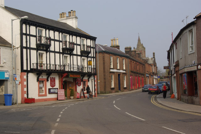
Lockerbie (, gd, Locarbaidh) is a small town in Dumfries and Galloway, south-western Scotland. It is about from Glasgow, and from the border with England. The 2001 Census recorded its population as 4,009. The town came to international attention in December 1988 when the wreckage of Pan Am Flight 103 crashed there following a terrorist bomb attack aboard the flight. Prehistory and archaeology In 2006, ahead of the construction of a new primary and secondary school archaeologists from CFA Archaeology under took excavations. They discovered the remains of a large (27 x 8m) Neolithic timber hall that dated to somewhere between 3950 BC to 3700 BC. The archaeologists found it was in use for some time as some of the posts had been replaced. Flax seeds were found in the timber hall showing the people were processing flax. This is an extremely rare find with only one other site in Scotland showing evidence of flax production in the Neolithic period. Like with most other Neolithic t ... [...More Info...] [...Related Items...] OR: [Wikipedia] [Google] [Baidu] |
Dumfriesshire
Dumfriesshire or the County of Dumfries or Shire of Dumfries (''Siorrachd Dhùn Phris'' in Gaelic) is a historic county and registration county in southern Scotland. The Dumfries lieutenancy area covers a similar area to the historic county. In terms of historic counties it borders Kirkcudbrightshire to the west, Ayrshire to the north-west, Lanarkshire, Peeblesshire and Selkirkshire to the north, and Roxburghshire to the east. To the south is the coast of the Solway Firth, and the English county of Cumberland. Dumfriesshire has three traditional subdivisions, based on the three main valleys in the county: Annandale, Eskdale and Nithsdale. These had been independent provinces in medieval times but were gradually superseded as administrative areas by the area controlled by the sheriff of Dumfries, or Dumfriesshire. A Dumfriesshire County Council existed from 1890 until 1975. Since 1975, the area of the historic county has formed part of the Dumfries and Galloway council are ... [...More Info...] [...Related Items...] OR: [Wikipedia] [Google] [Baidu] |
List Of Places In Dumfries And Galloway
''Map of places in Dumfries and Galloway compiled from this list'' This List of places in Dumfries and Galloway is a list of links for any town, village, hamlet, castle, golf course, historic house, hill fort, lighthouse, nature reserve, reservoir, river, loch, and other place of interest in the historic counties of Kirkcudbrightshire, Dumfriesshire and Wigtownshire within the Dumfries and Galloway council area of Scotland. A * Ae * Airds of Kells * Airieland * Amisfield *Anglo-Scottish border * Annan, Annan railway station * Annandale, Annandale Water *Anwoth *Ardwell *Auchen Castle * Auchencairn, Auchencairn Bay B * Balcary Point * Balmaclellan * Balmaghie * Bankend *Bargrennan *Beattock *Beeswing * Bogrie Hill *Bogue * Borgue *Bridge of Dee * Brydekirk C *Caerlaverock, Caerlaverock Cairn, Caerlaverock Castle, Caerlaverock NNR, * Cairngaan * Cairn Valley, Cairn Valley Light Railway *Cairnryan *Canonbie * Capenoch Loch *Cardoness Castle *Cargenbridge * ... [...More Info...] [...Related Items...] OR: [Wikipedia] [Google] [Baidu] |
List Of Civil Parishes In Scotland
This is a list of the 871 civil parishes in Scotland. *The 871 parishes are listed here Context From 1845 to 1930, parishes formed part of the local government system of Scotland: having parochial boards from 1845 to 1894, and parish councils from 1894 until 1930. The parishes, which had their origins in the ecclesiastical parishes of the Church of Scotland, often overlapped county boundaries, largely because they reflected earlier territorial divisions. In the early 1860s, many parishes which were physically detached from their county were re-allocated to the county by which they were surrounded; some border parishes were transferred to neighbouring counties. This affects the indexing of such things as birth, marriage, and death registrations and other records indexed by county. In 1891, there were further substantial changes to the areas of many parishes, as the boundary commission appointed under the Local Government (Scotland) Act 1889 eliminated many anomalies, and a ... [...More Info...] [...Related Items...] OR: [Wikipedia] [Google] [Baidu] |
Fields Near Lockerbie - Geograph
Fields may refer to: Music *Fields (band), an indie rock band formed in 2006 *Fields (progressive rock band), a progressive rock band formed in 1971 *Fields (album), ''Fields'' (album), an LP by Swedish-based indie rock band Junip (2010) * "Fields", a song by Sponge from ''Rotting Piñata'' (1994) Businesses * Field's, a shopping centre in Denmark * Fields (department store), a chain of discount department stores in Alberta and British Columbia, Canada Places in the United States * Fields, Oregon, an unincorporated community * Fields (Frisco, Texas), an announced planned community Other uses * Fields (surname), a list of people with that name * Fields Avenue (other), various roads * Fields Institute, a research centre in mathematical sciences at the University of Toronto * Fields Medal, for outstanding achievement in mathematics * Caulfield Grammarians Football Club, also known as The Fields * FIELDS, a spacecraft instrument on the Parker Solar Probe See also * ... [...More Info...] [...Related Items...] OR: [Wikipedia] [Google] [Baidu] |
Old Norse
Old Norse, Old Nordic, or Old Scandinavian, is a stage of development of North Germanic dialects before their final divergence into separate Nordic languages. Old Norse was spoken by inhabitants of Scandinavia and their overseas settlements and chronologically coincides with the Viking Age, the Christianization of Scandinavia and the consolidation of Scandinavian kingdoms from about the 7th to the 15th centuries. The Proto-Norse language developed into Old Norse by the 8th century, and Old Norse began to develop into the modern North Germanic languages in the mid-to-late 14th century, ending the language phase known as Old Norse. These dates, however, are not absolute, since written Old Norse is found well into the 15th century. Old Norse was divided into three dialects: ''Old West Norse'' or ''Old West Nordic'' (often referred to as ''Old Norse''), ''Old East Norse'' or ''Old East Nordic'', and '' Old Gutnish''. Old West Norse and Old East Norse formed a dialect ... [...More Info...] [...Related Items...] OR: [Wikipedia] [Google] [Baidu] |
Netherplace
Netherplace is a hamlet in East Renfrewshire. It is to the west of Newton Mearns, and adjacent to the M77 motorway The M77 motorway is a motorway in Scotland. It begins in Glasgow at the M8 motorway at Kinning Park, and terminates near Kilmarnock at Fenwick, becoming the A77 dual carriageway. Changes were made in 2005 segregating a lane on the M8 motor .... The settlement is almost entirely along the Netherplace Road. It contains a farm, as well as some houses, and a reservoir. It also used to be home to the Netherplace Dye Works, which was demolished in 2016, after a fly infestation across the towns of Newton Mearns and Clarkston. References Villages in East Renfrewshire {{Scotland-geo-stub ... [...More Info...] [...Related Items...] OR: [Wikipedia] [Google] [Baidu] |
Roman Empire
The Roman Empire ( la, Imperium Romanum ; grc-gre, Βασιλεία τῶν Ῥωμαίων, Basileía tôn Rhōmaíōn) was the post- Republican period of ancient Rome. As a polity, it included large territorial holdings around the Mediterranean Sea in Europe, North Africa, and Western Asia, and was ruled by emperors. From the accession of Caesar Augustus as the first Roman emperor to the military anarchy of the 3rd century, it was a Principate with Italia as the metropole of its provinces and the city of Rome as its sole capital. The Empire was later ruled by multiple emperors who shared control over the Western Roman Empire and the Eastern Roman Empire. The city of Rome remained the nominal capital of both parts until AD 476 when the imperial insignia were sent to Constantinople following the capture of the Western capital of Ravenna by the Germanic barbarians. The adoption of Christianity as the state church of the Roman Empire in AD 380 and the fall of the Western ... [...More Info...] [...Related Items...] OR: [Wikipedia] [Google] [Baidu] |
See Of Galloway
The Roman Catholic Diocese of Galloway ( la, Dioecesis Candidae Casae o Gallovidianus) is an ecclesiastical territory or diocese of the Roman Catholic Church in Scotland. The pre-Reformation Diocese of Galloway, held to have been founded by St Ninian in the fifth century, had broken allegiance with Rome in 1560, and disappeared in 1689 in the (official) Church of Scotland but continued in the Episcopal Church of Scotland. The modern Roman Catholic diocese incorporates the local authority areas of Dumfries and Galloway, South Ayrshire, East Ayrshire and parts of North Ayrshire, (Cumbrae). The bishop's cathedra is at St Margaret's Cathedral, Ayr. The diocese was re-established by the Roman Catholic Church on 4 March 1878, with its cathedral in Dumfries and its territory covering the sparse and rural counties of Dumfriesshire, Kirkcudbrightshire, Wigtownshire and parts of Ayrshire. Following the reorganisation of the Archdiocese of Glasgow in 1947, parishes to the north of ... [...More Info...] [...Related Items...] OR: [Wikipedia] [Google] [Baidu] |
Viking
Vikings ; non, víkingr is the modern name given to seafaring people originally from Scandinavia (present-day Denmark, Norway and Sweden), who from the late 8th to the late 11th centuries raided, pirated, traded and settled throughout parts of Europe.Roesdahl, pp. 9–22. They also voyaged as far as the Mediterranean, North Africa, Volga Bulgaria, the Middle East, and North America. In some of the countries they raided and settled in, this period is popularly known as the Viking Age, and the term "Viking" also commonly includes the inhabitants of the Scandinavian homelands as a collective whole. The Vikings had a profound impact on the early medieval history of Scandinavia, the British Isles, France, Estonia, and Kievan Rus'. Expert sailors and navigators aboard their characteristic longships, Vikings established Norse settlements and governments in the British Isles, the Faroe Islands, Iceland, Greenland, Normandy, and the Baltic coast, as well as alon ... [...More Info...] [...Related Items...] OR: [Wikipedia] [Google] [Baidu] |


