|
Drava Banovina
The Drava Banovina or Drava Banate ( Slovene and Serbo-Croatian: ''Dravska banovina''), was a province (banovina) of the Kingdom of Yugoslavia between 1929 and 1941. This province consisted of most of present-day Slovenia and was named for the Drava River. The capital city of the Drava Banovina was Ljubljana. Borders According to the 1931 Constitution of the Kingdom of Yugoslavia, Also in 1931, the Municipality of Štrigova (now in Croatia) was separated from the Čakovec District and the rest of Međimurje and was included in the Ljutomer District in the Drava Banovina. Administration The Drava Banovina was administratively subdivided into 29 counties (called ''srez''): Aftermath In 1941 the World War II Axis powers occupied the Drava Banovina, and it was divided largely between Nazi Germany and Fascist Italy, while Hungary annexed Prekmurje and the Independent State of Croatia annexed some smaller border areas. Following World War II the region was reconstituted, w ... [...More Info...] [...Related Items...] OR: [Wikipedia] [Google] [Baidu] |
Subdivisions Of The Kingdom Of Yugoslavia
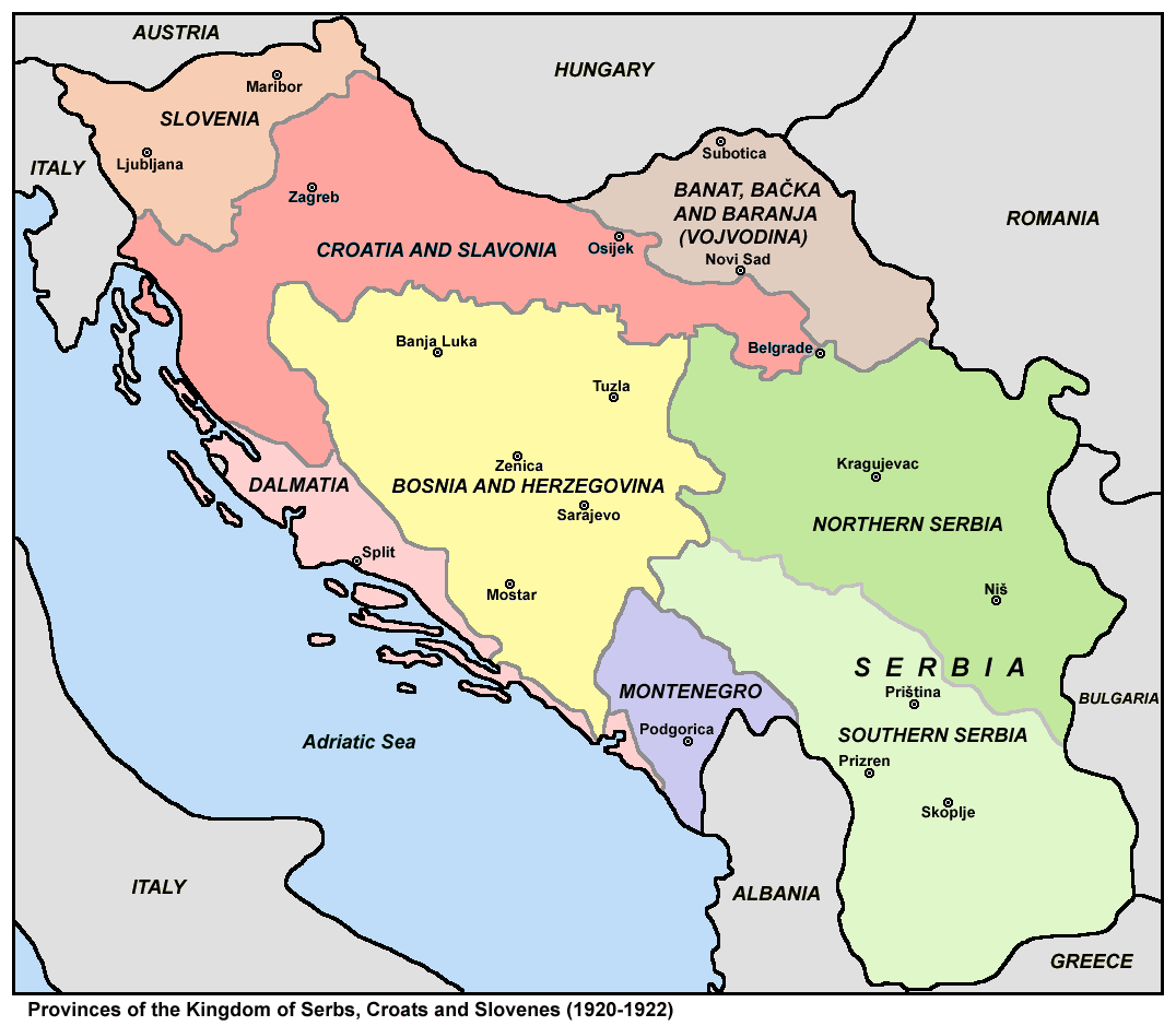
The subdivisions of the Kingdom of Yugoslavia (initially known as the Kingdom of Serbs, Croats, and Slovenes) existed successively in three different forms. From 1918 to 1922, the kingdom maintained the pre-World War I subdivisions of Yugoslavia's predecessor states. In 1922, the state was divided into 33 ''oblasts'' or provinces and, in 1929, a new system of nine banates (in Serbo-Croatian, the word for "banate" is ''banovina'') was implemented. Pre-Yugoslav subdivisions (1918–1922) From 1918 to 1922, Kingdom of Serbs, Croats, and Slovenes continued to be subdivided into the pre-World War I divisions of Austria-Hungary and the formerly independent kingdoms of Serbia and Montenegro. Provinces (''pokrajine'') were: # Slovenia # Croatia and Slavonia # Dalmatia # Bosnia and Herzegovina # Banat, Bačka and Baranja # Serbia ## Northern Serbia ## Southern Serbia # Montenegro These were subdivided into districts and counties: # District of Andrijevica (former Montenegro) # Distric ... [...More Info...] [...Related Items...] OR: [Wikipedia] [Google] [Baidu] |
Ljutomer
Ljutomer (; german: Luttenberg) is a town in northeastern Slovenia, east of Maribor. It is the seat of the Municipality of Ljutomer. Traditionally it was part of the region of Styria. It is now included in the Mura Statistical Region. The economy of Ljutomer is largely based on grape farming and wine making. Name Ljutomer was attested in written records in 1211 as ''Lvtenwerde'' (and as ''Lůtenwerde'' in 1242, ''Lvtenberch'' in 1249, ''Lutenberg'' in 1269, ''Luetemberg'' in 1380, and ''Lutemberg'' in 1440). The names with ''-berg'' referred to the town itself, and those with ''-werd'' to the wider area. Until the early 19th century, the only Slovene name for the town was ''Lotmerk'', borrowed from German.Snoj, Marko. 2009. Etimološki slovar slovenskih zemljepisnih imen. Ljubljana: Modrijan and Založba ZRC, p. 376. The modern Slovene name was first coined by Stanko Vraz in a letter from 1838, in which he wrote "do Ljutmera" ('to Ljutomer'). This and other variations were creat ... [...More Info...] [...Related Items...] OR: [Wikipedia] [Google] [Baidu] |
Štrigova
Štrigova (german: Stridau; hu, Stridóvár) is a village and municipality in Međimurje County, in northern Croatia. History Oldest archaeological finds in Štrigova municipality are from Roman period. Burial mounds and fragments of pottery were found in the hamlet of Trnovčak. Fragments of the roman roads were found at the same locality. The settlement Štrigova is first time mentioned in 1271 as ''Castr. Strigo'' (English: ''Fort Strigo''). During that time fort was in possession of Arnold of Stridó. In year 1290 Andrew the Venetian, later king of Hungary and Croatia, was captured in fort Štrigova by Arnold of Stridó, and was sent to Vienna in captivity. In year 1334 Štrigova was recorded as Catholic parish named ''Sancte Marie Magdalene de Strigo'' in Census of parishes of Zagreb Diocese. From the late Middle Ages until the beginning of the 20th century, Štrigova has the rights of a Market town. During the 15th century feudal proprietor of Međimurje Frederick II, ... [...More Info...] [...Related Items...] OR: [Wikipedia] [Google] [Baidu] |
Logatec
Logatec (; german: Loitsch, it, Longatico) is a town in Slovenia. It is the seat of the Municipality of Logatec. It is located roughly in the centre of Inner Carniola, between the capital Ljubljana and Postojna. The town of Logatec has seen rapid industrial development and immigration since the completion of the nearby A1 motorway to the coast. Name The name ''Logatec'' is of Celtic origin, probably derived from Celtic ''*longatis'' 'ferryman, boatman', from the Proto-Celtic word ''*longā'' 'ship', thus meaning 'ferrymen's settlement'. The name became ''Longaticum'' in Latin, which was borrowed into Slavic as ''*Lǫgatьcь''. Early attestations of the Slavic name include ''Logach'' in 1265 (and ''Logatzc'' in 1296, ''Logatsch'' in 1307, ''Logacz'' in 1319, and ''de Logas'' in 1354). History The earliest mentions of the settlement are from Roman times (Roman way station ''Mansio Longatico''). The vicinity of trade routes between the interior and the coast has always playe ... [...More Info...] [...Related Items...] OR: [Wikipedia] [Google] [Baidu] |
Kočevje
Kočevje (; german: Gottschee; ''Göttscheab'' or ''Gətscheab'' in the local Gottscheerish dialect; it, Cocevie) is a city in the Municipality of Kočevje in southern Slovenia. It is the seat of the municipality. Geography The town is located at the foot of the Kočevski Rog karst plateau on the Rinža River in the historic Lower Carniola region. It is now part of the Southeast Slovenia Statistical Region. The Rinža River flows through the town. Lake Kočejve, a former open-pit coal mine, lies northeast of the town center. Climate Kočevje features a humid continental climate (''Dfb''/''Cfb''). Name Kočevje was attested in written sources in 1363 as ''Gotsche'' (and as ''Gotsew'' in 1386, ''Kotsche'' in 1425, and ''propre Koczeuiam'' in 1478). The name is derived from ''*Hvojčevje'' (from ''hvoja'' 'fir, spruce'), referring to the local vegetation. The initial ''hv-'' changed to ''k-'' under the influence of German phonology. Older discredited explanations inc ... [...More Info...] [...Related Items...] OR: [Wikipedia] [Google] [Baidu] |
Črnomelj
Črnomelj (; in older sources also ''Černomelj'', german: Tschernembl''Leksikon občin kraljestev in dežel zastopanih v državnem zboru,'' vol. 6: ''Kranjsko''. 1906. Vienna: C. Kr. Dvorna in Državna Tiskarna, p. 4.) is a town in southeastern Slovenia. It is the seat of the Municipality of Črnomelj. It lies on the left bank of the Lahinja and Dobličica rivers. The municipality is at the heart of the area of White Carniola, the southeastern part of the traditional region of Lower Carniola. It is now included in the Southeast Slovenia Statistical Region. It includes the hamlets of Čardak, Kočevje, Kozji Plac, Loka, and Nova Loka. Name Črnomelj was first attested in written sources in 1228 as ''Schirnomel'' (and as ''Zernomel'' in 1263, ''Zermenli'' in 1277, and ''Tscherneml'' in 1490). The name is derived from ''*Čьrnomľь'', based on the hypocorism ''*Čьrnomъ'', thus originally meaning 'Črnom's settlement'. In the modern German the name was ''Tschernembl''. Until 1 ... [...More Info...] [...Related Items...] OR: [Wikipedia] [Google] [Baidu] |
Metlika
Metlika (; german: Möttling''Leksikon občin kraljestev in dežel zastopanih v državnem zboru,'' vol. 6: ''Kranjsko''. 1906. Vienna: C. Kr. Dvorna in Državna Tiskarna, p. 10.) is a town in southeastern Slovenia. It is the seat of the Municipality of Metlika. It lies on the left bank of the Kolpa River on the border with Croatia. It is in the heart of the area of White Carniola, the southeastern part of the traditional region of Lower Carniola. It is now included in the Southeast Slovenia Statistical Region. Name Metlika was first mentioned in written sources in 1228 as ''Metlica'' (and as ''Methlica'' in 1268 and ''Metlika'' in 1337). The name is derived from the Slovene common noun ''metlika'' 'goosefoot', thus referring to the local flora. In the past the German name was ''Möttling''. History Archaeological evidence has shown that the area has been settled since prehistoric times. From about 1205 it was incorporated into the Imperial March of Carniola and was granted to ... [...More Info...] [...Related Items...] OR: [Wikipedia] [Google] [Baidu] |
Novo Mesto
Novo Mesto (; sl, Novo mesto; also known by other alternative names) is a city on a bend of the Krka River in the City Municipality of Novo Mesto in southeastern Slovenia, close to the border with Croatia. The town is traditionally considered the economic and cultural centre of the historical Lower Carniola region. Name Novo Mesto was attested in historical sources in 1365 as ''Růdolfswerde'' (and as ''Rudolfswerd'' in 1392 and ''Noua Mesta'' in 1419). The German name (spelled ''Rudolfswerth'' in the modern era) is a compound of the personal name ''Rudolf'' and ''wert'' 'island, peninsula, land above the water', and refers to Rudolf IV, Duke of Austria, who conferred town rights upon the settlement in 1365. The parallel German name ''Neustadtl'' was also in use (attested as ''Newestat'' in 1365, and probably a translation of the Slovene name). The name used for the settlement before 1365 is unknown. The Slovene name ''Novo mesto'' literally means 'new town'; names like this a ... [...More Info...] [...Related Items...] OR: [Wikipedia] [Google] [Baidu] |
Krško
Krško (; german: Gurkfeld) is a town in eastern Slovenia. It is the seat of the City municipality of Krško. The town lies on the Sava River and on the northwest edge of the Krško Plain ( sl, Krško polje), which is part of the larger Krka Flat ( sl, Krška ravan). The area is divided between the traditional regions of Styria (territory on the left bank of the Sava) and Lower Carniola (territory on the right bank of the Sava). The entire municipality is now included in the Lower Sava Statistical Region. Slovenia's only nuclear power plant, the Krško Nuclear Power Plant, lies southeast of the town. Name The name of the settlement was changed from ''Krško'' to ''Videm–Krško'' in 1953. The name ''Krško'' was restored in 1964. In the past the German name was ''Gurkfeld''. History Archaeological evidence shows that the area was settled in prehistoric times. Along the Sava River, numerous Bronze and Iron Age sites as well as Roman finds show continuous occupation. After ... [...More Info...] [...Related Items...] OR: [Wikipedia] [Google] [Baidu] |


