|
Don Lorenzo Hubbell
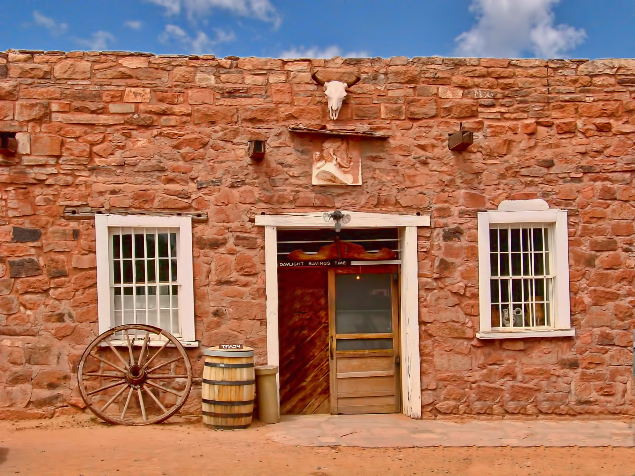
John Lorenzo Hubbell (November 27, 1853 – November 12, 1930) was a member of the Arizona State Senate. He was elected to serve in the 1st Arizona State Legislature from Apache County. He served in the Senate from March 1912 until March 1914. Hubbell was the long-time owner of the Hubbell Trading Post established in 1878 on the Navajo Reservation in Ganado, Arizona. The trading post is preserved as the Hubbell Trading Post National Historic Site. Early life John Lorenzo Hubbell was the son of James (Santiago) Lawrence Hubbell, a pioneer from Salisbury, Connecticut, who traveled to the Southwest, settling in New Mexico in 1848, where he became a government contractor, specializing in cattle. His mother was Julianita Gutierrez, the heiress of an old New Mexican family, who inherited large estates in the New Mexico territory, holding the Pajarito Land Grand from 1739 from the Spanish government. His parents built the historic Gutiérrez Hubbell House. His father had come to th ... [...More Info...] [...Related Items...] OR: [Wikipedia] [Google] [Baidu] |
Apache County
Apache County is in the northeast corner of the U.S. state of Arizona. Shaped in a long rectangle running north to south, as of the 2020 census, its population was 66,021. The county seat is St. Johns. Most of the county is occupied by part of the federally recognized Navajo Nation and the Fort Apache Indian Reservation, respectively. History The United States acquired this territory following its victory in the Mexican-American War in 1848. It was originally part of the New Mexico Territory established at the time. In 1863, during the American Civil War, Congress established the Arizona Territory to improve regional administration. It operated until 1912 when it was admitted as a state. In 1879 the Tenth Territorial Legislature organized Apache County from the eastern section of Yavapai County; officially all land east of 109°45′ W was included in the new county. As population increased in the area, by 1895, the legislature divided this county to create Navajo County and ... [...More Info...] [...Related Items...] OR: [Wikipedia] [Google] [Baidu] |
National Register Of Historic Places
The National Register of Historic Places (NRHP) is the United States federal government's official list of districts, sites, buildings, structures and objects deemed worthy of preservation for their historical significance or "great artistic value". A property listed in the National Register, or located within a National Register Historic District, may qualify for tax incentives derived from the total value of expenses incurred in preserving the property. The passage of the National Historic Preservation Act (NHPA) in 1966 established the National Register and the process for adding properties to it. Of the more than one and a half million properties on the National Register, 95,000 are listed individually. The remainder are contributing resources within historic districts. For most of its history, the National Register has been administered by the National Park Service (NPS), an agency within the U.S. Department of the Interior. Its goals are to help property owners and inte ... [...More Info...] [...Related Items...] OR: [Wikipedia] [Google] [Baidu] |
Fred Harvey Company
The Fred Harvey Company was the owner of the Harvey House chain of restaurants, hotels and other hospitality industry businesses alongside railroads in the Western United States. It was founded in 1876 by Fred Harvey to cater to the growing number of train passengers. When Harvey died in 1901, his family inherited 45 restaurants and 20 dining cars in 12 states. During World War II, Harvey Houses opened again to serve soldiers as they traveled in troop trains across the U.S. By 1968, when it was sold to Amfac, Inc. (now Xanterra Parks and Resorts, as of 2002), the Fred Harvey Company was the sixth largest food retailer in the United States. It left behind a lasting legacy of good food, dedication to customers, decent treatment of employees, and preservation of local traditions.Fried, Stephen. ''Appetite for America: how visionary businessman Fred Harvey built a railroad hospitality empire''. New York: Bantam Books, 2010. History The company traces its origins to the 187 ... [...More Info...] [...Related Items...] OR: [Wikipedia] [Google] [Baidu] |
Gallup, New Mexico
Zuni: ''Kalabwaki'' , settlement_type = City , nickname = "Indian Capital of the World" , motto = , image_skyline = Gallup, New Mexico.jpg , imagesize = 250px , image_caption = Motels and businesses in Gallup , image_flag = Flag of Gallup, New Mexico.svg , image_seal = , image_map = McKinley_County_New_Mexico_Incorporated_and_Unincorporated_areas_Gallup_Highlighted.svg , mapsize = 250px , map_caption = Location of Gallup in New Mexico , image_map1 = , mapsize1 = , map_caption1 = , pushpin_map = USA , pushpin_map_caption = Location in the United States , subdivision_type = Country , subdivision_type1 = State , subdivision_type2 = County , subdivision_name = United States , subdivision_name1 = New Mexico , subdivision_name2 = McKinley , governmen ... [...More Info...] [...Related Items...] OR: [Wikipedia] [Google] [Baidu] |
Long Walk Of The Navajo
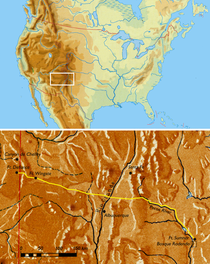
The Long Walk of the Navajo, also called the Long Walk to Bosque Redondo ( nv, Hwéeldi), was the 1864 deportation and attempted ethnic cleansing of the Navajo people by the United States federal government. Navajos were forced to walk from their land in what is now Arizona to eastern New Mexico. Some 53 different forced marches occurred between August 1864 and the end of 1866. Some anthropologists claim that the "collective trauma of the Long Walk...is critical to contemporary Navajos' sense of identity as a people". Introduction The traditional Navajo homeland spans from Arizona through western New Mexico, where the Navajo had houses, planted crops and raised livestock. There was a long historical pattern in the Southwest of groups or bands raiding and trading with each other, with treaties being made and broken. This included interactions between Navajo, Spanish, Mexican, Pueblos, Apache, Comanche, Ute, and later European Americans. Individual civilians and Native ... [...More Info...] [...Related Items...] OR: [Wikipedia] [Google] [Baidu] |
Ganado Mucho
Ganado may refer to: * Ganado, Arizona ** Ganado Airport * Ganado, Texas * Ganado High School (other) * Ganado Independent School District, Texas * Ganado Unified School District, Arizona * Albert Ganado (born 1924), Maltese lawyer and historian * Herbert Ganado (1906-1979), Maltese writer and politician * Maria Grech Ganado (born 1943), Maltese author and academic See also * '' Ganado bravo'', a term for a Spanish Fighting Bull * Ganados, enemy characters from ''Resident Evil 4'' * Gazini Ganados Gazini Christiana Jordi Acopiado Ganados (; born December 26, 1995) is a Filipino model and beauty pageant titleholder who was crowned Miss Universe Philippines 2019. She represented the Philippines at the Miss Universe 2019 pageant and finish ... (born 1995), Filipino-Palestinian fashion model and beauty pageant titleholder * {{disambig, geo, surname Spanish-language surnames Maltese-language surnames Surnames of Philippine origin ... [...More Info...] [...Related Items...] OR: [Wikipedia] [Google] [Baidu] |
Pueblo, Colorado
Pueblo () is a List of municipalities in Colorado#Home rule municipality, home rule municipality that is the county seat and the List of municipalities in Colorado, most populous municipality of Pueblo County, Colorado, Pueblo County, Colorado, United States. The city population was 111,876 at the 2020 United States Census, making Pueblo the List of municipalities in Colorado, ninth most populous city in Colorado. Pueblo is the principal city of the Pueblo, CO Metropolitan Statistical Area and a major city of the Front Range Urban Corridor. Pueblo is situated at the confluence of the Arkansas River and Fountain Creek, south of the Colorado State Capitol in Denver. The area is considered semi-arid desert land, with approximately of precipitation annually. With its location in the "Banana Belt", Pueblo tends to get less snow than the other major cities in Colorado. Pueblo is one of the largest steel-producing cities in the United States, for which reason Pueblo is referred to ... [...More Info...] [...Related Items...] OR: [Wikipedia] [Google] [Baidu] |
Hopi Reservation
The Hopi Reservation ( Hopi: Hopituskwa) is a Native American reservation for the Hopi and Arizona Tewa people, surrounded entirely by the Navajo Nation, in Navajo and Coconino counties in north-eastern Arizona, United States. The site has a land area of 2,531.773 sq mi (6,557.262 km²) and as of the 2000 census had a population of 6,946. The two nations formerly shared the Navajo–Hopi Joint Use Area until the Navajo–Hopi land settlement act created an artificial boundary through the area. The partition of this area, commonly known as Big Mountain, by acts of Congress in 1974 and 1996, has resulted in continuing controversy. The system of villages unites three mesas in the pueblo style traditionally used by the Hopi. Walpi is the oldest village on First Mesa, having been established in 1690 after the villages at the foot of mesa '' Koechaptevela'' were abandoned for fear of Spanish reprisal after the 1680 Pueblo Revolt. The Tewa people live on First Mesa. Hopi a ... [...More Info...] [...Related Items...] OR: [Wikipedia] [Google] [Baidu] |
Hopi Indians
The Hopi are a Native Americans in the United States, Native American ethnic group who primarily live on the Hopi Reservation in northeastern Arizona, United States. As of the United States Census, 2010, 2010 census, there are 19,338 Hopi in the country. The Hopi Tribe is a Tribal sovereignty in the United States, sovereign nation within the United States and has government-to-government relations with the United States federal government. Particular villages retain autonomy under the Hopi Constitution and Bylaws. The Hopi language is one of 30 in the Uto-Aztecan language family. The majority of Hopi people are enrolled in the Hopi Tribe of Arizona but some are enrolled in the Colorado River Indian Tribes. The Hopi Reservation covers a land area of . The Hopi encountered Spaniards in the 16th century, and are historically referred to as Puebloan peoples, Pueblo people, because they lived in villages (''pueblos'' in the Spanish language). The Hopi are thought to be descended from ... [...More Info...] [...Related Items...] OR: [Wikipedia] [Google] [Baidu] |
Paiute Indians
Paiute (; also Piute) refers to three non-contiguous groups of indigenous peoples of the Great Basin. Although their languages are related within the Numic group of Uto-Aztecan languages, these three groups do not form a single set. The term "Paiute" does not refer to a single, unique, unified group of Great Basin tribes, but is a historical label comprising: * Northern Paiute people of northeastern California, northwestern Nevada, eastern Oregon, and southern Idaho * Southern Paiute people of northern Arizona, southern Nevada, and southwestern Utah * Mono people The Mono ( ) are a Native American people who traditionally live in the central Sierra Nevada, the Eastern Sierra (generally south of Bridgeport), the Mono Basin, and adjacent areas of the Great Basin. The Eastern mono is often grouped under t ... of east central California, divided into Owens Valley Paiute (Eastern Mono) and Western Mono (Monache) {{Authority control ... [...More Info...] [...Related Items...] OR: [Wikipedia] [Google] [Baidu] |
Panguitch, Utah
Panguitch ( ) is a city in and the county seat of Garfield County, Utah, United States. The population was 1,520 at the 2010 census, and was estimated in 2018 to be 1,691. The name Panguitch comes from a Southern Paiute word meaning “Big Fish,” likely named after the plentiful nearby lakes hosting rainbow trout year-round. Geography Panguitch is located on the western edge of Garfield County at (37.822234, -112.434650), in the valley of the Sevier River. U.S. Route 89 passes through the center of town, leading north to Junction and south to Orderville. Utah State Route 143 leads southwest from Panguitch to Panguitch Lake in Dixie National Forest. According to the United States Census Bureau, the city has a total area of , all land. Climate Panguitch has a cool semi-arid climate (Köppen ''BSk'') with summers featuring hot afternoons and cold mornings, and cold, dry winters. The high altitude and relatively high latitude means that mornings are cold throughout the ye ... [...More Info...] [...Related Items...] OR: [Wikipedia] [Google] [Baidu] |


