|
Districts Of Copenhagen
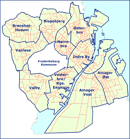
Districts of Copenhagen are often based on informal designations based on historic origins, often with alternative names and loosely defined boundaries. Copenhagen Municipality is divided into 10 official administrative districts but they often comprise areas of a heterogeneous character which are informally not seen as one district. Some districts have earlier been official subdivisions and thus have semi-official boundaries. Copenhagen postal code designations often correspond to district boundaries but in some cases differ from them, as an example parts of the city centre has the postal code København V which is generally associated with Vesterbro. Official districts Copenhagen Municipality has ten official administrative districts. They are: Indre By, Vesterbro/Kongens Enghave, Nørrebro, Østerbro, Amager Øst, Amager Vest, Valby, Bispebjerg, Vanløse and Brønshøj-Husum. The districts serve administrative, statistical and tax purposes but are not boroughs since th ... [...More Info...] [...Related Items...] OR: [Wikipedia] [Google] [Baidu] |
Copenhagen Municipality
Copenhagen Municipality ( da, Københavns Kommune), also known in English as the Municipality of Copenhagen, located in the Capital Region of Denmark, is the largest of the four municipalities that constitute the City of Copenhagen (), the other three being Dragør, Frederiksberg, and Tårnby. The Municipality of Copenhagen constitutes the historical city centre and the majority of its landmarks. It is the most populous in the country with a population of 652,564 inhabitants (), and covers in area,. Copenhagen Municipality is located at the Zealand and Amager islands and totally surrounds Frederiksberg Municipality on all sides. The strait of Øresund lies to the east. The city of Copenhagen has grown far beyond the municipal boundaries from 1901, when Frederiksberg Municipality was made an enclave within Copenhagen Municipality. Frederiksberg has the largest population density of the municipalities of Denmark. The municipal seat of government is the Copenhagen City ... [...More Info...] [...Related Items...] OR: [Wikipedia] [Google] [Baidu] |
Amagerbro
Amagerbro is an area in the northern part of the island Amager and a district in Copenhagen. The area is known as a working class area, and has approximately 20,000 inhabitants. The district has two metro stations, Amagerbro station and Lergravsparken station. Amagerbrogade, a main shopping street, runs through it. The district is bordered by the Amager Fælled nature reserve, the Christianhavn Ramparts and Kløvermarken Kløvermarken (the Clover Field) is a large green space in the Amager East district of Copenhagen, Denmark. Originally a military area, it has later been home to both Copenhagen's first air field and a camp for German refugees after World War II. ..., the industrial area near Amager Boulevard and Øresundsvej. The main shopping and business area is Amagerbrogade and its sidestreets. Establishments in Amagerbro include Kofoeds School offering assistance to people with social problems, the Sundholm Activity Centre accommodating the homeless for short periods ... [...More Info...] [...Related Items...] OR: [Wikipedia] [Google] [Baidu] |
Nyboder
Nyboder (English: New mallHouses) is a historic row house district of former Naval barracks in Copenhagen, Denmark. It was planned and first built by Christian IV to accommodate a need for housing for the personnel of the rapidly growing Royal Danish Navy and their families during that time. While the area is still commonly associated with the name of its founder as one of his numerous building projects around Copenhagen, the Nyboder seen today was in fact, except for a single row of houses in St. Paulsgade, built from 1757. Nyboder is today very much associated with their yellow colour and "Nyboder yellow" is in Danish often used as a generic term to refer to their exact hue of yellow. However, the original colour of the development was red and white. History Christian IV's Nyboder Under Christian IV the Royal Danish Navy grew rapidly and there was an urgent need for suitable accommodation for its personnel and their families. Bremerholm already offered similar housing for ... [...More Info...] [...Related Items...] OR: [Wikipedia] [Google] [Baidu] |
Frederiksstaden
Frederiksstaden is a district in Copenhagen, Denmark. Constructed during the reign of Frederick V in the second half of the 18th century, it is considered to be one of the most important rococo complexes in Europe and was included in the 2006 Danish Culture Canon. It was developed to commemorate the 300 years jubilee of the House of Oldenburg ascending to the Danish throne. A. G. Moltke was in charge of the project and Nicolai Eigtved was the main architect. Frederiksstaden has Amalienborg Palace, the Danish residence palace complex with François Joseph Saly's equestrian statue monument to King Frederik V of Denmark in the middle of the octagonal plaza, and Frederik's Church at its center. Together they create an axis that was extended with the creation of the new Copenhagen Opera House in 2005 on the other side of the harbor basin. The district is characterized by straight broad streets in a straight-angled street layout. The streets are lined by bourgeois houses, mansions an ... [...More Info...] [...Related Items...] OR: [Wikipedia] [Google] [Baidu] |
New Copenhagen
New Copenhagen (Danish: Ny København) or St. Ann's Town (Danish: Sankt Annæ By) was a 17th-century expansion of fortified Copenhagen, Denmark. The original plan for the area, from 1649, was later abandoned. It now comprises neighbourhoods and localities such as Frederiksstaden, the Nyboder neighbourhood, Nyhavn, Larsens Plads and Kongens Nytorv. History Expansion of the fortified city As part of his aspirations to strengthen Copenhagen as a regional centre, Christian IV decided to expand the area of the fortified city northwards. As early as 1606, when his modernization of the fortifications began, he had purchased 200 hectares of land outside the Eastern City Gate. His intention was to redevelop this area into a new district referred to as Ny København (English: New Copenhagen) or Sankt Annæ By (Saint Ann's Town). The plan was to change the course of Østervold, which at that time made a bend and ran along what is today Gothersgade and Kongens Nytorv. The new Østervold wo ... [...More Info...] [...Related Items...] OR: [Wikipedia] [Google] [Baidu] |
Latin Quarter, Copenhagen
The Latin Quarter ( da, Latinerkvarteret) is a neighbourhood in central Copenhagen, Denmark. It is bounded by Nørregade to the west, Vestergade to the south, Vester Voldgade to the east and Nørre Voldgade to the north. The name refers to the Latin language, which was once widely spoken in and around the University, whose historic home is situated on the other side of Nørregade. Most of the student life has now been relocated to four new campuses but the area is still known for its lively atmosphere with an abundance of boutiques, cafés and night clubs. History The area around Our Lady's Square has been a centre for learning and thus use of the Latin language since the Middle Ages. The term ''Latinerkvarteret'' was formerly used for a larger area on both sides of the square, including Store Kannikestræde, Krystalgade and Fiolstræde. In 1208, Bishop Peder Sunesøn founded a Latin school and a body of noble canons in association with the Church of Our Lady. When the Universi ... [...More Info...] [...Related Items...] OR: [Wikipedia] [Google] [Baidu] |
Shopping Street
A shopping street or shopping district is a designated road or quarter of a city/town that is composed of individual retail establishments (such as stores, boutiques, restaurants, and shopping complexes). Such areas will typically be pedestrian-oriented, with street-side buildings, wide sidewalks, etc. They may be located along a designated street, or clustered in mixed-use commercial area within the city. In larger cities, there may be multiple shopping streets or districts, often with distinct characteristics each. Often times, businesses in these areas will be represented by a designated business improvement association. Below is a list of shopping streets and districts by city. Africa Cameroon * Yaounde — Avenue Kennedy * Douala — Avenue Ahmadou Ahidjo, Boulevard de la liberté Egypt * Cairo — Khan el-Khalili, Al-Hussein Area * Alexandria — Manshiya, Berkleley * Sharm El-Sheikh — Naama Bay, Shark's Bay Ghana * Accra — Oxford Street Morocco * Casa ... [...More Info...] [...Related Items...] OR: [Wikipedia] [Google] [Baidu] |
Urbanization
Urbanization (or urbanisation) refers to the population shift from rural to urban areas, the corresponding decrease in the proportion of people living in rural areas, and the ways in which societies adapt to this change. It is predominantly the process by which towns and cities are formed and become larger as more people begin living and working in central areas. Although the two concepts are sometimes used interchangeably, urbanization should be distinguished from urban growth. Urbanization refers to the ''proportion'' of the total national population living in areas classified as urban, whereas urban growth strictly refers to the ''absolute'' number of people living in those areas. It is predicted that by 2050 about 64% of the developing world and 86% of the developed world will be urbanized. That is equivalent to approximately 3 billion urbanites by 2050, much of which will occur in Africa and Asia. Notably, the United Nations has also recently projected that nearly all gl ... [...More Info...] [...Related Items...] OR: [Wikipedia] [Google] [Baidu] |
Amagerbrogade
Amagerbrogade is the main shopping street and thoroughfare of the part of Copenhagen, Denmark that is located on the island of Amager . It begins at the end of the causeway which connects Amager to Christianshavn and the city centre on the other side of the harbour, and runs south until it reaches the municipal border with Tårnby where it continues as Amager Landevej. The street marks the border between Amager Vest and Amager Øst, two of the ten official districts of Copenhagen. Amagerbrogade arose when the country road leading in and out of Copenhagen's Amager Gate was urbanized towards the end of the 18th century after the city's old fortifications had been decommissioned and the no-built zone outside them released. It is one of four such ''-bro streets''. History Om the 18th century the road network outside Amager Gate was generally limited and in a poor state. From 1780 to 1790 the main road to Store Magleby and Dragør was upgraded but only a short stretch was cobbl ... [...More Info...] [...Related Items...] OR: [Wikipedia] [Google] [Baidu] |
Østerbrogade
Østerbrogade is the principal shopping street and thoroughfare in the Østerbro district of Copenhagen, Denmark. It extends from Lille Triangel at the north-eastern tip of The Lakes, passes Trianglen, and continues to Svanemøllen station from where it becomes Strandvejen. History Østerbrogade originated as the old main road which extended from the Eastern City Gate, paradoxically located north of the city. Originally it was simply known as Østerbro and the name only referred to the stretch between the city gate and present day Trianglen where it continued as Strandvejen (English: The Beach Road) along the coast. After the city gate was dismantled in 1859 and the city was gradually allowed to develop beyond the old fortifications, still more of the old main road was included in Østerbrogade until it finally reached all the way to its present-day terminus at Svanemøllen in 1949. Redevelopment of the area along the road began in 1854 when the Danish Medical Associatio ... [...More Info...] [...Related Items...] OR: [Wikipedia] [Google] [Baidu] |
Nørrebrogade
Nørrebrogade is the principal shopping street of the Nørrebro district of Copenhagen, Denmark. It runs from The Lakes in the southeast to Nørrebro station in the northwest, linking Frederiksborggade and Queen Louise's Bridge with Frederikssundsvej. The street passes Assistens Cemetery, Nørrebro Runddel and the Superkilen linear park. Buildings include the multipurpose venue Nørrebrohallen and two churches. History Nørrebrogade originates in the road that led in and out of Copenhagen's Northern City Gate. Few buildings were located along the road due to the so-called Demarcation Line enforced restrictions on the construction of buildings outside Copenhagen's fortifications. The road was built over after the demarcation line was moved to the lakes in 1952. Notable buildings and residents Alderstrøst (No. 9) was built by Håndværkerforeningen in 1860 - 1862 to provide affordable housing for old craftsmen. The Neoclassical building was designed by Theodor Sørensen. ... [...More Info...] [...Related Items...] OR: [Wikipedia] [Google] [Baidu] |


.png)

