|
Districts Of British India
The Districts of British India were administrative units of the Government of the British Raj or Indian Empire. Districts were generally subdivisions of the provinces and divisions of British India History Districts, often known as '' zillas'' in vernacular, were established as subdivisions of the provinces (''praanths'' in vernacular) and divisions of British India that were under one of the three Presidencies. ''Imperial Gazetteer of India'', vol. V, 1908 Most of the districts that were created during the British Raj became Districts of India after the independence of India. Historical districts The following list includes only districts of British India that became extinguished or that saw major changes in their history: Districts in the Madras Presidency *Anantapur district * Bellary district (including parts of Present-day Kurnool district) *Chingleput District *Coimbatore District (Madras Presidency) *Cuddapah district * Ganjam district (including present-day Gajapati dist ... [...More Info...] [...Related Items...] OR: [Wikipedia] [Google] [Baidu] |
British Raj
The British Raj (; from Hindi ''rāj'': kingdom, realm, state, or empire) was the rule of the British Crown on the Indian subcontinent; * * it is also called Crown rule in India, * * * * or Direct rule in India, * Quote: "Mill, who was himself employed by the British East India company from the age of seventeen until the British government assumed direct rule over India in 1858." * * and lasted from 1858 to 1947. * * The region under British control was commonly called India in contemporaneous usage and included areas directly administered by the United Kingdom, which were collectively called British India, and areas ruled by indigenous rulers, but under British paramountcy, called the princely states. The region was sometimes called the Indian Empire, though not officially. As ''India'', it was a founding member of the League of Nations, a participating nation in the Summer Olympics in 1900, 1920, 1928, 1932, and 1936, and a founding member of the United Nations in San F ... [...More Info...] [...Related Items...] OR: [Wikipedia] [Google] [Baidu] |
Srikakulam District
Srikakulam district is one of the twenty-six districts of the States and union territories of India, Indian state of Andhra Pradesh, located in the Uttarandhra region of the state, with its headquarters located at Srikakulam. It is one of the six districts, located in the extreme northeastern direction of the state. It was formerly known as Chicacole , and was under Ganjam district till 1936 April 1, then merged under Vizagapatam district .This was once the part of ancient Kalinga (historical region), Kalinga. History Prehistory Evidence of early historic man and his activities during the Stone Age and Iron Age have been discovered at Sangamayya Konda and Dannanapeta. The speciality of Dannanapeta Iron Age megalithic site is a large single capstone as a dolmen with 36 ft in length and 14 ft in width and 2 ft thickness. Sailada Hills consists of 36 upright rocks and natural caves used for habitation by Iron Age man in Amudalavalasa mandal of the district. J ... [...More Info...] [...Related Items...] OR: [Wikipedia] [Google] [Baidu] |
Tanjore District (Madras Presidency)
Thanjavur District was one of the districts in the erstwhile Madras Presidency of British India. It covered the area of the present-day districts of Thanjavur, Tiruvarur, Nagapattinam, Mayiladuthurai and Aranthangi taluk, Karambakkudi taluk of Pudukkottai District in Tamil Nadu. Apart from being a bedrock of Hindu orthodoxy, Tanjore was a centre of Chola cultural heritage and one of the richest and most prosperous districts in Madras Presidency. Tanjore district was constituted in 1799 when the Thanjavur Maratha ruler Serfoji II ceded most of his kingdom to the British East India Company in return for his restitution on the throne. Tanjore district, which is situated on the Cauvery Delta, is one of the richest rice-growing regions in South India. It was scarcely affected by famines such as the Great Famine of 1876–78. Geography The Tanjore District was bounded by the districts of South Arcot in the north, Trichinopoly to the west and south and the Pudukkottai State and M ... [...More Info...] [...Related Items...] OR: [Wikipedia] [Google] [Baidu] |
South Canara
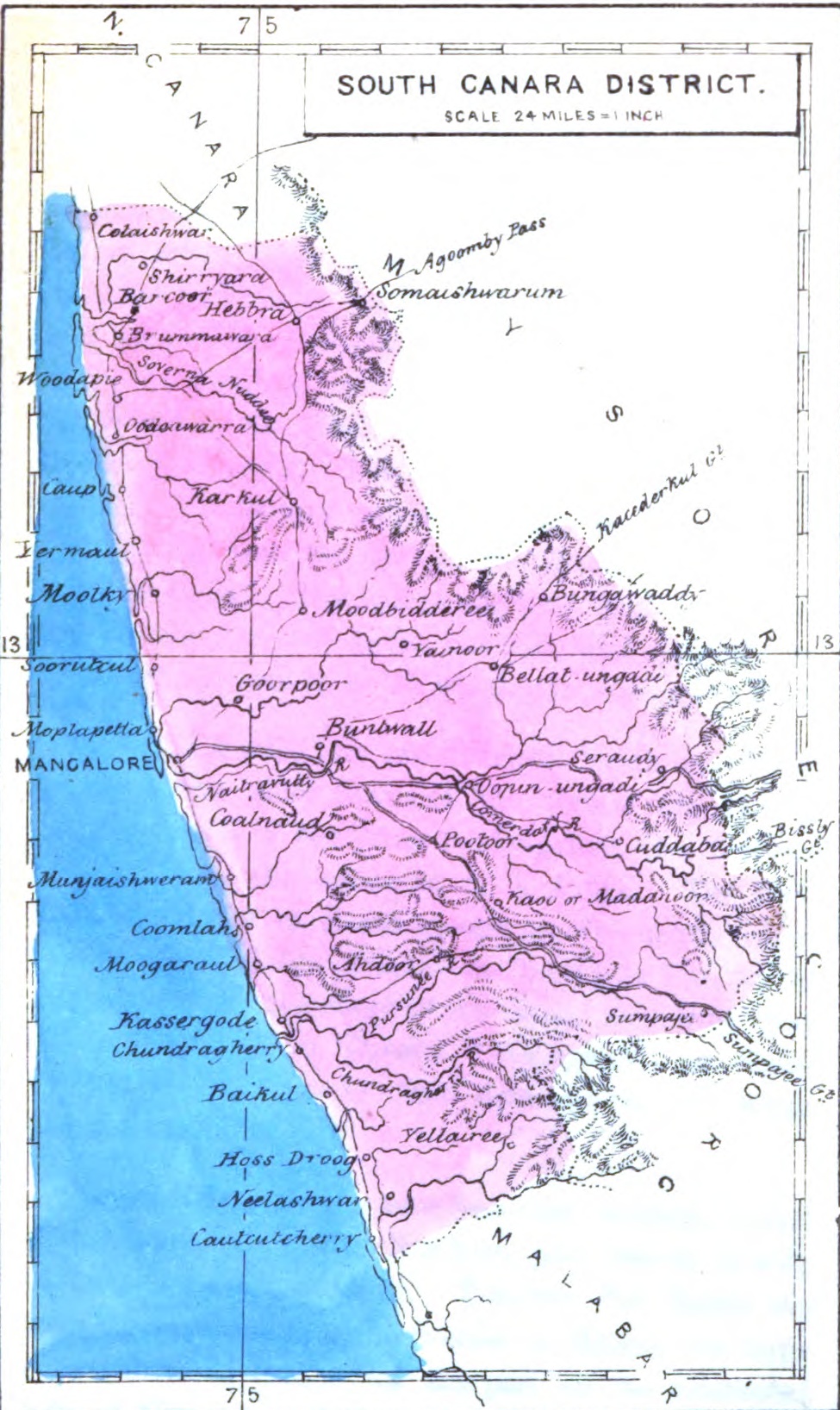
South Canara was a district of the Madras Presidency of British India, located at . It comprised the towns of Kassergode and Udipi and adjacent villages, with the capital in Mangalore city. South Canara was one of the most heterogeneous areas of Madras Presidency, with Tulu, Malayalam, Kannada, Konkani, Marathi, Urdu, and Beary languages being spoken side by side. It was succeeded by the Tulu-speaking areas of Dakshina Kannada district, the Malayalam-speaking area of Kasaragod district and the Amindivi islands sub-division of the Laccadives, in the year 1956. Geography Mangalore was the administrative headquarters of the district. The district covered an area of . South Canara District was bordered by North Canara to north, the princely state of Mysore to east, Coorg state to southeast, Malabar District to south, and Arabian Sea to west. South Canara was one of the two districts on the western coast (Malabar coast) of Madras Presidency along with Malabar District (otherwi ... [...More Info...] [...Related Items...] OR: [Wikipedia] [Google] [Baidu] |
South Arcot District (Madras Presidency)
South Arcot District was a district in the Madras Presidency of British India. It covered the area of the present-day districts of Cuddalore, Kallakurichi and Viluppuram in the Indian state of Tamil Nadu. The district was divided into eight taluks and covered a total area of . The administrative headquarters was the town of Cuddalore. In ancient times, South Arcot was a part of the Chola and the Pallava kingdoms. British presence in the district dates to 1690 when the British East India Company set up a factory at Fort St David near Cuddalore. South Arcot was the scene of confrontation between the British and the French and the British and Tipu Sultan. The British took over the administration in 1781 and established full sovereignty in 1801. The economy is largely agricultural. South Arcot is noteworthy for lignite mines in Neyveli. History South Arcot was the southern portion of the Mughal province (''subah'') of Arcot. In ancient times, the northern part of South Arcot ... [...More Info...] [...Related Items...] OR: [Wikipedia] [Google] [Baidu] |
North Arcot
North Arcot was a former district in Madras Presidency, acquired by the annexation of the Arcot State in 1855 when its Nawab died without issue. It had Chittoor as its headquarters (currently in Andhra pradesh). On 1 April 1911, the Chittoor district was separated from North Arcot. The remaining district, with Vellore as its headquarters, passed intact into the Madras State of independent India. On 30 September 1989 the district was split into Tiruvannamalai-Sambuvarayar district (present-day Tiruvannamalai district) and North Arcot Ambedkar district (present-day Vellore district). It contained the present day districts of Tiruvannamalai, Vellore, Chittoor, Tirupati, Tirupattur and Ranipet. History Historically, the name "Arcot" is said to be derived from a linguistic corruption of the original Tamil word "Aaru Kaadu", meaning "Six Forests". The region is described in common folklore as lush region flanked by six forests in which is said to have resided a myriad of sages and ... [...More Info...] [...Related Items...] OR: [Wikipedia] [Google] [Baidu] |
Malabar District
Malabar District, also known as Malayalam District, was an administrative district on the southwestern Malabar Coast of Bombay Presidency (1792-1800) and Madras Presidency (1800-1947) in British India, and independent India's Madras State (1947-1956). It was the most populous and the third-largest district in the erstwhile Madras State. The British district included the present-day districts of Kannur, Kozhikode, Wayanad, Malappuram, Palakkad (excluding Chittur town), Chavakad Taluk and parts of Kodungallur Taluk of Thrissur district (former part of Ponnani Taluk), and Fort Kochi area of Ernakulam district in the northern and central parts of present Kerala state, the Lakshadweep Islands, and a major portion of the Nilgiris district in Tamil Nadu. The detached settlements of Tangasseri and Anchuthengu, which were British colonies within the kingdom of Travancore in southern Kerala, also formed part of Malabar District until 1927. Malayalam was the administrative as well as ... [...More Info...] [...Related Items...] OR: [Wikipedia] [Google] [Baidu] |
Madura District (Madras Presidency)
Madurai District was one of the districts of the Madras Presidency of British India. It covered the present-day districts of Madurai, Dindigul, Theni, Ramanathapuram, Sivagangai and parts of Virudhunagar District in the Indian state of Tamil Nadu. History Madura is a district were the centre of the Pandya kingdom and its capital city of Madurai was flourishing ever since the Sangam period. In the 10th century AD, the region was conquered by the rising Chola power. The Pandyas governed as subordinate from the 10th to the 13th century AD when they asserted their independence and established their supremacy over the declining Cholas. After a short and progressive rule, the Pandyas were defeated by the Delhi Sultanate whose ruled Alauddin Khalji sacked Madura. The region was ruled by the Madurai Sultanate for some time before it was conquered by the Vijayanagar Empire. The Vijayanagar kings were succeeded by the Madurai Nayak kingdom whose demise in 1736 left behind a huge voi ... [...More Info...] [...Related Items...] OR: [Wikipedia] [Google] [Baidu] |
Prakasam District
Prakasam district is one of the thirteen districts in the coastal Andhra region of the Indian state of Andhra Pradesh. It was formed in 1970 and reorganised in 2022 on April 4. The headquarters of the district is Ongole. It is located on the western shore of Bay of Bengal and is bounded by Bapatla district and Palnadu districts on the north, Nandyal district on the west, Kadapa and Nellore districts on the south. A part of north west region also borders with Nagarkurnool district of Telangana. It is the largest district in the state with an area of and had a population of 2,288,026 as per 2011 Census of India. Etymology The district was named after the patriot and first Chief Minister of Andhra State Tanguturi Prakasam, also known as Andhra Kesari, who was born in the village of Vinodarayunipalem. It was accordingly renamed as Prakasam District in the year 1972. History Prakasam district was originally constituted on 2 February 1970, carved out of Guntur, Nellore and Kurno ... [...More Info...] [...Related Items...] OR: [Wikipedia] [Google] [Baidu] |
Kurnool District
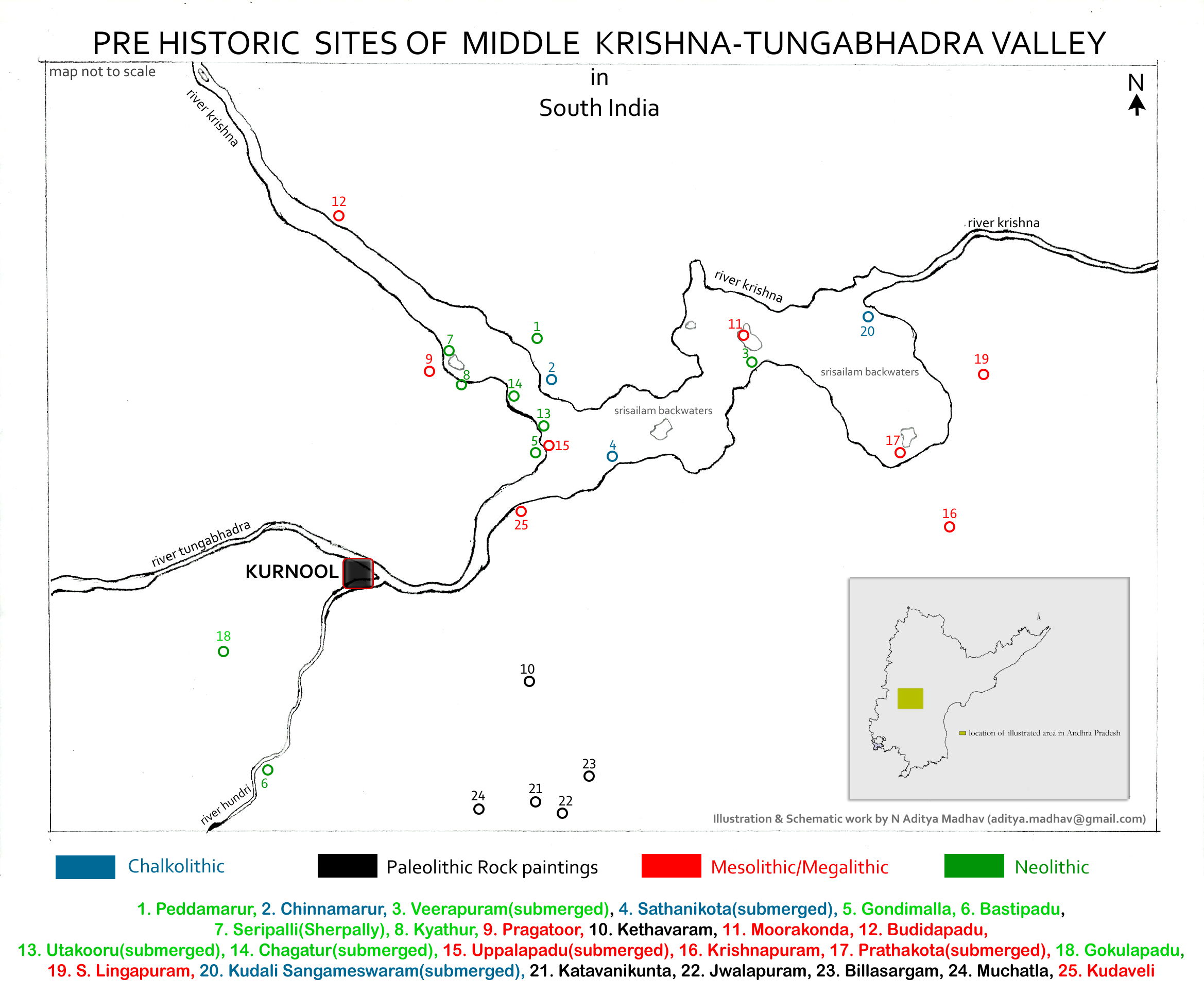
Kurnool district is one of the eight districts in the Rayalaseema region of the Indian state of Andhra Pradesh. It is located in the North western part of the state and is bounded by Jogulamba Gadwal district of Telangana in the north, Raichur district of Karnataka in the northwest, Bellary district of Karnataka in the west, Anantapur district in the south and Nandyal district in the east. The city of Kurnool is the headquarters of the district. It has a population of 4,053,463 of which 28.35% were urban as of 2011. History The Ketavaram rock paintings are dated back to the Paleolithic era (located at a distance of from Kurnool). Jurreru Valley, Katavani Kunta and Yaganti in the district have some important rock arts and paintings in their vicinity, which are dated back to 35,000 to 40,000 years ago. Belum Caves are geologically and historically important caves in the district. There are indications that Jain and Buddhist monks were occupying these caves centuries ago ... [...More Info...] [...Related Items...] OR: [Wikipedia] [Google] [Baidu] |


