|
Dutton, Lancashire
Dutton is a civil parish in the Borough of Ribble Valley in the English county of Lancashire, its principal settlement being the hamlet of Lower Dutton. The population of the civil parish at the 2011 census was 238. The parish is northeast of Ribchester. It was part of Preston Rural District throughout the district's existence from 1894 to 1974. ''Vision of Britain'', accessed 9 June 2014 In 1974 the parish became part of Ribble Valley. See also * *Ribchester Bridge
[...More Info...] [...Related Items...] OR: [Wikipedia] [Google] [Baidu] |
United Kingdom Census 2011
A Census in the United Kingdom, census of the population of the United Kingdom is taken every ten years. The 2011 census was held in all countries of the UK on 27 March 2011. It was the first UK census which could be completed online via the Internet. The Office for National Statistics (ONS) is responsible for the census in England and Wales, the General Register Office for Scotland (GROS) is responsible for the census in Scotland, and the Northern Ireland Statistics and Research Agency (NISRA) is responsible for the census in Northern Ireland. The Office for National Statistics is the executive office of the UK Statistics Authority, a non-ministerial department formed in 2008 and which reports directly to Parliament. ONS is the UK Government's single largest statistical producer of independent statistics on the UK's economy and society, used to assist the planning and allocation of resources, policy-making and decision-making. ONS designs, manages and runs the census in England an ... [...More Info...] [...Related Items...] OR: [Wikipedia] [Google] [Baidu] |
Ribble Valley
Ribble Valley is a local government district with borough status within the non-metropolitan county of Lancashire, England. The total population of the non-metropolitan district at the 2011 Census was 57,132. Its council is based in Clitheroe. Other places include Whalley, Longridge and Ribchester. The area is so called due to the River Ribble which flows in its final stages towards its estuary near Preston. The area is popular with tourists who enjoy the area's natural unspoilt beauty, much of which lies within the Forest of Bowland. The district was formed on 1 April 1974 under the Local Government Act 1972, as a merger of the municipal borough of Clitheroe, Longridge urban district, Clitheroe Rural District, part of Blackburn Rural District, part of Burnley Rural District, and part of Preston Rural District, as well as the Bowland Rural District from the West Riding of Yorkshire, hence the addition of the Red Rose of Lancaster and White Rose of York on the coun ... [...More Info...] [...Related Items...] OR: [Wikipedia] [Google] [Baidu] |
Lancashire
Lancashire ( , ; abbreviated Lancs) is the name of a Historic counties of England, historic county, Ceremonial County, ceremonial county, and non-metropolitan county in North West England. The boundaries of these three areas differ significantly. The non-metropolitan county of Lancashire was created by the Local Government Act 1972. It is administered by Lancashire County Council, based in Preston, Lancashire, Preston, and twelve district councils. Although Lancaster, Lancashire, Lancaster is still considered the county town, Preston is the administrative centre of the non-metropolitan county. The ceremonial county has the same boundaries except that it also includes Blackpool and Blackburn with Darwen, which are unitary authorities. The historic county of Lancashire is larger and includes the cities of Manchester and Liverpool as well as the Furness and Cartmel peninsulas, but excludes Bowland area of the West Riding of Yorkshire transferred to the non-metropolitan county ... [...More Info...] [...Related Items...] OR: [Wikipedia] [Google] [Baidu] |
Ribble Valley (UK Parliament Constituency)
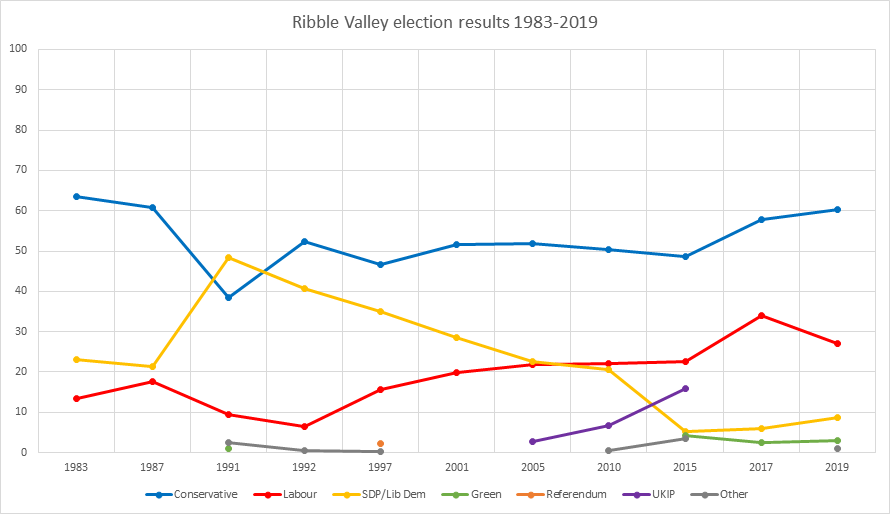
Ribble Valley is a constituency in Lancashire represented in the House of Commons of the UK Parliament since 1992 by Nigel Evans, a Conservative. Evans has served as a Deputy Speaker of the House of Commons and Second Deputy Chairman of Ways and Means since January 2020; he previously served as First Deputy Chairman of Ways and Means from 2010 to 2013. History The Ribble Valley constituency was created in 1983 almost wholly from the former seat of Clitheroe. Much of the eastern part of the constituency lies within the historic county boundaries of the West Riding of Yorkshire. Constituency profile The constituency enjoys scenic villages for both commuters and the retired, has slightly higher than national average income and much lower than average reliance upon social housing. As of December 2012, unemployment was significantly lower than the national average. With the exception of one year when, following a by-election, it was represented by a Liberal Democrat, the MP has bee ... [...More Info...] [...Related Items...] OR: [Wikipedia] [Google] [Baidu] |
Civil Parish
In England, a civil parish is a type of Parish (administrative division), administrative parish used for Local government in England, local government. It is a territorial designation which is the lowest tier of local government below districts of England, districts and metropolitan and non-metropolitan counties of England, counties, or their combined form, the Unitary authorities of England, unitary authority. Civil parishes can trace their origin to the ancient system of Parish (Church of England), ecclesiastical parishes, which historically played a role in both secular and religious administration. Civil and religious parishes were formally differentiated in the 19th century and are now entirely separate. Civil parishes in their modern form came into being through the Local Government Act 1894, which established elected Parish councils in England, parish councils to take on the secular functions of the vestry, parish vestry. A civil parish can range in size from a sparsely ... [...More Info...] [...Related Items...] OR: [Wikipedia] [Google] [Baidu] |
Hamlet (place)
A hamlet is a human settlement that is smaller than a town or village. Its size relative to a parish can depend on the administration and region. A hamlet may be considered to be a smaller settlement or subdivision or satellite entity to a larger settlement. The word and concept of a hamlet has roots in the Anglo-Norman settlement of England, where the old French ' came to apply to small human settlements. Etymology The word comes from Anglo-Norman ', corresponding to Old French ', the diminutive of Old French ' meaning a little village. This, in turn, is a diminutive of Old French ', possibly borrowed from ( West Germanic) Franconian languages. Compare with modern French ', Dutch ', Frisian ', German ', Old English ' and Modern English ''home''. By country Afghanistan In Afghanistan, the counterpart of the hamlet is the qala ( Dari: قلعه, Pashto: کلي) meaning "fort" or "hamlet". The Afghan ''qala'' is a fortified group of houses, generally with its ... [...More Info...] [...Related Items...] OR: [Wikipedia] [Google] [Baidu] |
Ribchester
Ribchester is a village and civil parish within the Ribble Valley district of Lancashire, England. It lies on the banks of the River Ribble, northwest of Blackburn and east of Preston. The village has a long history with evidence of Bronze Age beginnings. It is well known as a significant Roman site being the location of a Roman cavalry fort called Bremetennacum, some parts of which have been exposed by excavation. In common with many towns and villages in East Lancashire its later history was dominated by cotton weaving; firstly in the form of hand-loom weaving and later in two mills. Neither mill still operates and the village is primarily a dormitory village for commuters to the town of Blackburn and the cities of Preston and Manchester. The main access road into Ribchester is the B6245. From the north-west, this is Preston Road, which merges into Church Street. From the east, it is Blackburn Road, which, at its westernmost extremity, also links up with Church Stree ... [...More Info...] [...Related Items...] OR: [Wikipedia] [Google] [Baidu] |
Preston Rural District
Preston was a rural district in Lancashire, England from 1894 to 1974. It surrounded Preston on the north, west and east sides. The district was created under the Local Government Act 1894. It was abolished in 1974 under the Local Government Act 1972, with its area being split between the new districts of South Ribble, Preston and Ribble Valley. It contained the following parishes: * Barton, Broughton, Elston (until 1934 when merged into Grimsargh), Goosnargh, Grimsargh-with-Brockholes (until 1934 when merged into Grimsargh), Grimsargh (from 1934), Haighton, Lea Ashton Ingol and Cottam (until 1934 when split into Lea, Fulwood Urban District and the County Borough of Preston), Lea (from 1934), Whittingham and Woodplumpton which were all transferred to the Borough of Preston in 1974 * Dutton, Hothersall and Ribchester which were all transferred to Ribble Valley in 1974 * Cuerdale, Farington, Howick (until 1934 when merged into Penwortham), Hutton, The Holme (until m ... [...More Info...] [...Related Items...] OR: [Wikipedia] [Google] [Baidu] |
Listed Buildings In Dutton, Lancashire
Dutton is a civil parish in Ribble Valley, Lancashire, England, located to the northeast of Ribchester. The parish is rural, with the River Ribble running to the south. It contains 15 buildings that are recorded in the National Heritage List for England as designated listed buildings In the United Kingdom, a listed building or listed structure is one that has been placed on one of the four statutory lists maintained by Historic England in England, Historic Environment Scotland in Scotland, in Wales, and the Northern Ire .... These mainly consist of houses with related structures, or farm buildings, but there are also a church, a bridge and two cross bases. Key Buildings References Citations Sources * {{DEFAULTSORT:Dutton, Lancashire Lists of listed buildings in Lancashire Buildings and structures in Ribble Valley ... [...More Info...] [...Related Items...] OR: [Wikipedia] [Google] [Baidu] |
Ribchester Bridge
__NOTOC__ Ribchester Bridge is a toll-free, three-span bridge over the River Ribble near Ribchester, Lancashire, England. A Grade II listed structure, located about three quarters of a mile east of the village, it actually crosses the river between the civil parishes of Clayton-le-Dale and Dutton. The bridge carries the two-lane traffic of the B6245 Ribchester Road. Thought to have been constructed in 1774, it is built of sandstone and consists of three segmental arches on triangular cutwaters, with a string course and a solid parapet. The bridge has an overall length and width of (deck plus -wide parapets). The central span in the largest at with a rise of , with the others of differing, slightly smaller dimensions. This point on the river is above the tidal limit, the banks approximately above the Ordnance datum. It has been an important crossing for millennia with the Roman fort here positioned to guard it; however, the origin of the earliest bridge is uncertain. The cu ... [...More Info...] [...Related Items...] OR: [Wikipedia] [Google] [Baidu] |
Civil Parishes In Lancashire
A civil parish is a subnational entity, forming the lowest unit of local government in England. There are 219 civil parishes in the ceremonial county of Lancashire; Blackpool is completely unparished; Borough of Pendle, Pendle and Ribble Valley are entirely parished. At the 2001 census, there were 587,074 people living in the 219 parishes, accounting for 41.5 per cent of the county's population. History Parishes arose from Church of England divisions, and were originally purely ecclesiastical divisions. Over time they acquired civil administration powers.Angus Winchester, 2000, ''Discovering Parish Boundaries''. Shire Publications. Princes Risborough, 96 pages The Highways Act 1555 made parishes responsible for the upkeep of roads. Every adult inhabitant of the parish was obliged to work four days a year on the roads, providing their own tools, carts and horses; the work was overseen by an unpaid local appointee, the ''Surveyor of Highways''. The poor were looked after by the ... [...More Info...] [...Related Items...] OR: [Wikipedia] [Google] [Baidu] |


