|
Dryopteris Aemula
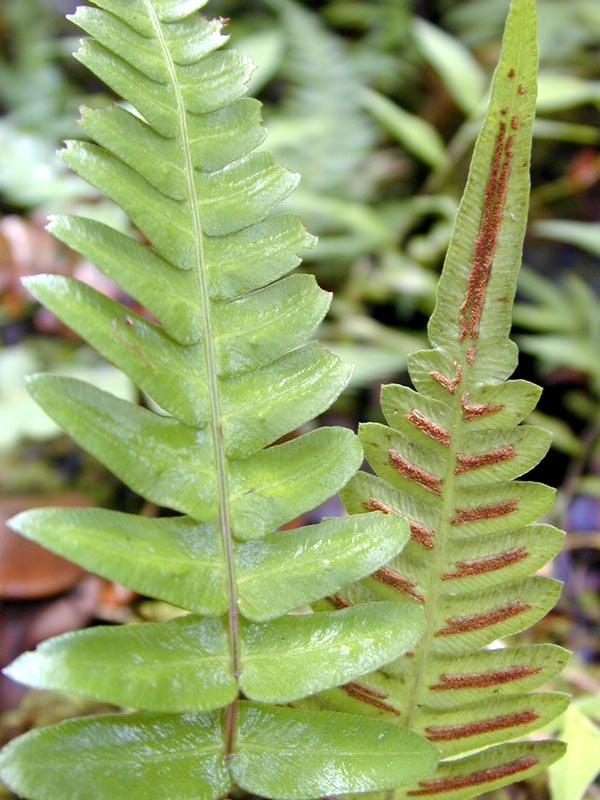
''Dryopteris aemula'', the hay-scented buckler-fern or hay-scented fern, is a species of perennial Leptosporangiate fern, leptosporangiate fern. Description ''Dryopteris aemula'' grows as a crown of fronds arising from a short ascending rhizome. The rachis is dark purple-brown with red-brown lanceolate scales. Leaves are tri-pinnate, triangular-ovate or triangular-lanceolate, long, often arching, semi-evergreen and pale yellow-green. Scattered small sessile glands grow on the underside or both surfaces of the fronds. Pinnation, Pinnae are slightly concave giving the frond a characteristic crisped appearance. The plant is hay-scented. Sorus, Sori or spore-producing organs occur in a row down each side of the midrib. The indusium of the sorus is irregularly toothed and edged with sessile glands. The plant does not reproduce vegetatively and relies upon spores to generate new individuals. Taxonomy Distribution ''Dryopteris aemula'' is confined to the atlantic coastal areas o ... [...More Info...] [...Related Items...] OR: [Wikipedia] [Google] [Baidu] |
Galloway
Galloway ( ; sco, Gallowa; la, Gallovidia) is a region in southwestern Scotland comprising the historic counties of Wigtownshire and Kirkcudbrightshire. It is administered as part of the council area of Dumfries and Galloway. A native or inhabitant of Galloway is called a Gallovidian. The place name Galloway is derived from the Gaelic ' ("amongst the '"). The , literally meaning "Stranger-'"; the specific identity of whom the term was applied to is unknown, but the predominant view is that it referred to an ethnic and/or cultural identity such as the Strathclyde Britons or another related but distinct population. A popular theory is that it refers to a population of mixed Scandinavian and Gaelic ethnicity that may have inhabited Galloway in the Middle Ages. Galloway is bounded by sea to the west and south, the Galloway Hills to the north, and the River Nith to the east; the border between Kirkcudbrightshire and Wigtownshire is marked by the River Cree. The definition has ... [...More Info...] [...Related Items...] OR: [Wikipedia] [Google] [Baidu] |
Spores
In biology, a spore is a unit of sexual or asexual reproduction that may be adapted for dispersal and for survival, often for extended periods of time, in unfavourable conditions. Spores form part of the life cycles of many plants, algae, fungi and protozoa. Bacterial spores are not part of a sexual cycle, but are resistant structures used for survival under unfavourable conditions. Myxozoan spores release amoeboid infectious germs ("amoebulae") into their hosts for parasitic infection, but also reproduce within the hosts through the pairing of two nuclei within the plasmodium, which develops from the amoebula. In plants, spores are usually haploid and unicellular and are produced by meiosis in the sporangium of a diploid sporophyte. Under favourable conditions the spore can develop into a new organism using mitotic division, producing a multicellular gametophyte, which eventually goes on to produce gametes. Two gametes fuse to form a zygote which develops into a new spor ... [...More Info...] [...Related Items...] OR: [Wikipedia] [Google] [Baidu] |
British NVC Community W17 (Quercus Petraea - Betula Pubescens - Dicranum Majus Woodland)
NVC community W17 (''Quercus petraea - Betula pubescens - Dicranum majus'' woodland) is one of the Woodland and scrub communities in the British National Vegetation Classification system, woodland Terminology used in connection with the British National Vegetation Classification, communities in the British National Vegetation Classification system. It is one of the six communities falling in the "mixed deciduous and oak/birch woodlands" group. This is a widely distributed community in northern and western Britain and represents mossy deciduous woodland of the uplands. There are four Terminology used in connection with the British National Vegetation Classification, subcommunities. Community composition Two Terminology used in connection with the British National Vegetation Classification, constant species are found in the tree canopy of this community: * Sessile oak (''Quercus petraea'') * Downy birch (''Betula pubescens'') Eight Terminology used in connection with the British Nat ... [...More Info...] [...Related Items...] OR: [Wikipedia] [Google] [Baidu] |
British National Vegetation Classification
__NOTOC__ The British National Vegetation Classification or NVC is a system of classifying natural habitat types in Great Britain according to the vegetation they contain. A large scientific meeting of ecologists, botanists, and other related professionals in the United Kingdom resulted in the publication of a compendium of five books: ''British Plant Communities'', edited by John S. Rodwell, which detail the incidence of plant species in twelve major habitat types in the British natural environment. They are the first systematic and comprehensive account of the vegetation types of the country. They cover all natural, semi-natural and major artificial habitats in Great Britain (not Northern Ireland) and represent fifteen years of research by leading plant ecologists. From the data collated from the books, commercial software products have been developed to help to classify vegetation identified into one of the many habitat types found in Great Britain – these include ''MATCH'' ... [...More Info...] [...Related Items...] OR: [Wikipedia] [Google] [Baidu] |
Medway Council
Medway Council is the local authority of Medway in Kent, England. It is a unitary authority, having the powers of a non-metropolitan county and district council combined. The council was created on 1 April 1998 and replaced Rochester-upon-Medway City Council and Gillingham Borough Council. Formation and city status Throughout the 19th century there had been proposals to join the Medway towns under a single authority. By 1903 moves began to take place: that year saw the creation of the Borough of Gillingham, to which, in 1928, the adjoining parish of Rainham was added. In 1944, a Medway Towns Joint Amalgamation Committee was formed by the borough corporations of Chatham, Gillingham and Rochester, to discuss the possibility of the towns forming a single county borough. In 1948 the Local Government Boundary Commission recommended that the area become a "most purposes" county borough, but the recommendation was not carried out. In 1956 the Joint Amalgamation Committee decide ... [...More Info...] [...Related Items...] OR: [Wikipedia] [Google] [Baidu] |
The Weald
The Weald () is an area of South East England between the parallel chalk escarpments of the North and the South Downs. It crosses the counties of Hampshire, Surrey, Sussex and Kent. It has three separate parts: the sandstone "High Weald" in the centre; the clay "Low Weald" periphery; and the Greensand Ridge, which stretches around the north and west of the Weald and includes its highest points. The Weald once was covered with forest, and its name, Old English in origin, signifies "woodland". The term is still used today, as scattered farms and villages sometimes refer to the Weald in their names. Etymology The name "Weald" is derived from the Old English ', meaning "forest" (cognate of German ''Wald'', but unrelated to English "wood", which has a different origin). This comes from a Germanic root of the same meaning, and ultimately from Indo-European. ''Weald'' is specifically a West Saxon form; '' wold'' is the Anglian form of the word. The Middle English form of the word i ... [...More Info...] [...Related Items...] OR: [Wikipedia] [Google] [Baidu] |
Oceanic Climate
An oceanic climate, also known as a marine climate, is the humid temperate climate sub-type in Köppen classification ''Cfb'', typical of west coasts in higher middle latitudes of continents, generally featuring cool summers and mild winters (for their latitude), with a relatively narrow annual temperature range and few extremes of temperature. Oceanic climates can be found in both hemispheres generally between 45 and 63 latitude, most notably in northwestern Europe, northwestern America, as well as New Zealand. Precipitation Locations with oceanic climates tend to feature frequent cloudy conditions with precipitation, low hanging clouds, and frequent fronts and storms. Thunderstorms are normally few, since strong daytime heating and hot and cold air masses meet infrequently in the region. In most areas with an oceanic climate, precipitation comes in the form of rain for the majority of the year. However, some areas with this climate see some snowfall annually during winter. M ... [...More Info...] [...Related Items...] OR: [Wikipedia] [Google] [Baidu] |
Macaronesia
Macaronesia (Portuguese: ''Macaronésia,'' Spanish: ''Macaronesia'') is a collection of four volcanic archipelagos in the North Atlantic, off the coasts of Africa and Europe. Each archipelago is made up of a number of List of islands in the Atlantic Ocean, Atlantic oceanic islands, which are formed by seamounts on the ocean floor whose peaks have risen above the ocean's surface. Some of the Macaronesian islands belong to Portugal, some belong to Spain, and the rest belong to Cape Verde. Politically, the islands belonging to Portugal and Spain are part of the European Union. Geologically, Macaronesia is part of the African Plate, African tectonic plate. Some of its islands – the Azores – are situated along the edge of that plate at the point where it abuts the Eurasian Plate, Eurasian and North American Plate, North American plates. In one biogeography, biogeographical system, the Cape Verde archipelago is in the Afrotropical realm while the other three archipelagos are in t ... [...More Info...] [...Related Items...] OR: [Wikipedia] [Google] [Baidu] |
Sorus
A sorus (pl. sori) is a cluster of sporangia (structures producing and containing spores) in ferns and fungi. A coenosorus (plural coenosori) is a compound sorus composed of multiple, fused sori. Etymology This New Latin word is from Ancient Greek σωρός (''sōrós'' 'stack, pile, heap'). Structure In lichens and other fungi, the sorus is surrounded by an external layer. In some red algae, it may take the form of depression into the thallus. In ferns, the sori form a yellowish or brownish mass on the edge or underside of a fertile frond. In some species, they are protected during development by a scale or film of tissue called the indusium, which forms an umbrella-like cover. Lifecycle significance Sori occur on the sporophyte generation, the sporangia within producing haploid meiospores. As the sporangia mature, the indusium shrivels so that spore release is unimpeded. The sporangia then burst and release the spores. As an aid to identification The shape, arrangemen ... [...More Info...] [...Related Items...] OR: [Wikipedia] [Google] [Baidu] |
William Aiton
William Aiton (17312 February 1793) was a Scotland, Scottish botanist. Aiton was born near Hamilton, Scotland, Hamilton. Having been regularly trained to the profession of a gardener, he travelled to London in 1754, and became assistant to Philip Miller, then superintendent of the Chelsea Physic Garden. In 1759 he was appointed director of the newly established Royal Botanic Gardens, Kew, botanical garden at Kew, where he remained until his death. He effected many improvements at the gardens, and in 1789 he published ''Hortus Kewensis'', a catalogue of the plants cultivated there. He is buried at nearby St. Anne's Church, Kew. A second and enlarged edition of the ''Hortus'' was brought out in 1810–1813 by his eldest son, William Townsend Aiton. Aiton is commemorated in the Specific epithet (botany), specific epithet ''aitonis''. In 1789, he classified the Sampaguita plant to the ''Jasmine, Jasminium'' genus and also named it as ''Arabian Jasmine'' because it was believed th ... [...More Info...] [...Related Items...] OR: [Wikipedia] [Google] [Baidu] |
Pinnation
Pinnation (also called pennation) is the arrangement of feather-like or multi-divided features arising from both sides of a common axis. Pinnation occurs in biological morphology, in crystals, such as some forms of ice or metal crystals, and in patterns of erosion or stream beds. The term derives from the Latin word ''pinna'' meaning "feather", "wing", or "fin". A similar concept is "pectination," which is a comb-like arrangement of parts (arising from one side of an axis only). Pinnation is commonly referred to in contrast to "palmation," in which the parts or structures radiate out from a common point. The terms "pinnation" and "pennation" are cognate, and although they are sometimes used distinctly, there is no consistent difference in the meaning or usage of the two words.Jackson, Benjamin, Daydon; A Glossary of Botanic Terms with their Derivation and Accent; Published by Gerald Duckworth & Co. London, 4th ed 1928 Plants Botanically, pinnation is an arrangement of discr ... [...More Info...] [...Related Items...] OR: [Wikipedia] [Google] [Baidu] |


