|
Drieborg
Drieborg (also: ''Stocksterhorn''; Gronings: ''Drijbörg'') is a dike village in the Dutch province of Groningen. It is a part of the municipality of Oldambt. History The village started along a dike on the Dollart as Stocksterhorn. In 1656, the dike was extended to Nieuweschans. Due to the proximity to the border, a redoubt was constructed in Stocksterhorn. In 1673, the Bishop of Münster conquered the redoubt. On 26 August 1818, the village was first referred to as Drieborg in the Provincial Council of Groningen. The origin of the name is unclear. The most likely explanation is "three boroughs" (fortified settlements), which however cannot be correct. The village used to be a part of the municipality of Beerta. Drieborg was mainly inhabited by farm workers. During the 20th century, Drieborg was a stronghold of the Communist Party of the Netherlands. In 1929, a widespread farmers' strike was organised in Drieborg. After World War II, 60 of the 170 houses in the village were de ... [...More Info...] [...Related Items...] OR: [Wikipedia] [Google] [Baidu] |
Oldambt (municipality)
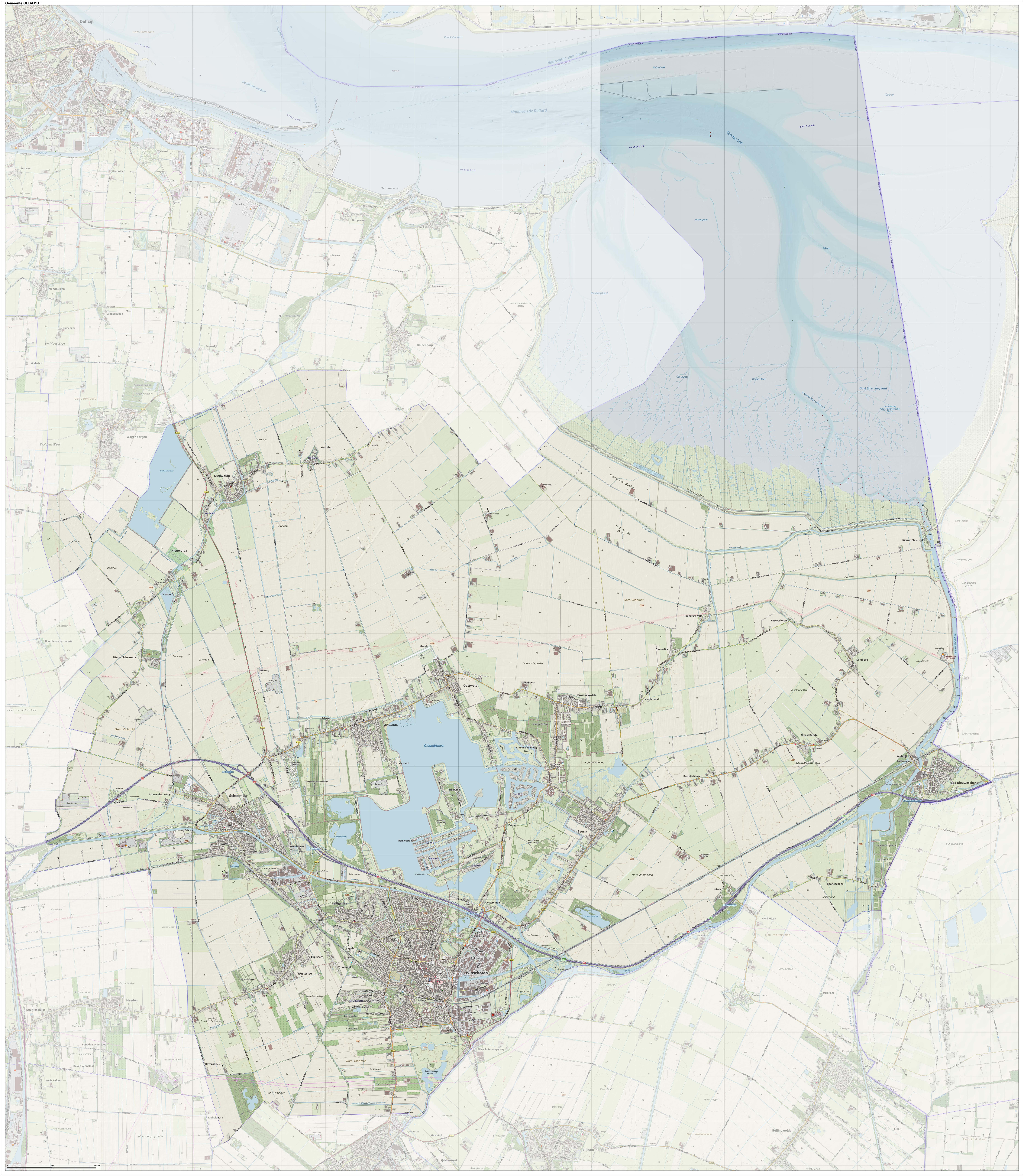
Oldambt () is a municipality with a population of in the province of Groningen in the Netherlands. It was established in 2010 by merging the municipalities of Reiderland, Scheemda, and Winschoten. It contains the city of Winschoten and these villages: History The name "Oldambt" from "Ol dambt" meaning "the old fill" is derived from land reclamation efforts, starting after the catastrophic floodings of the 13th century. The municipality of Oldambt was established 1 January 2010, as a merger of the former municipalities of Reiderland, Scheemda and Winschoten. Geography Oldambt is located at in the northeast of the province of Groningen in the northeast of the Netherlands on the border with Germany. Near Bad Nieuweschans is the easternmost point of the Netherlands. The municipality falls within the region of Oldambt and the western part falls within the region of Rheiderland. The municipality is bordered by the Dutch municipalities of Delfzijl (in the north), Slocht ... [...More Info...] [...Related Items...] OR: [Wikipedia] [Google] [Baidu] |
Reiderland
Reiderland () is a former municipality in the province Groningen in the northeastern Netherlands, which was founded in 1990 during a large municipal reorganisation. The former municipalities Finsterwolde and Bad Nieuweschans were abolished and added to Beerta. In 1992, the new municipality was given its current name. In 2010 it joined in the municipality Oldambt. Politics Reiderland was one of the few municipalities in the Netherlands that still had communist councillors after the dissolution of the Communist Party of the Netherlands in 1989. (As of 2006, it was one of only four Dutch municipalities to have any, the other three being Heiloo, Scheemda and Lemsterland.) The New Communist Party of the Netherlands was in fact the largest party in Reiderland from 1990 to 1998 and again from 2002 to 2006. Finsterwolde and Beerta, which was the only town in the Netherlands that ever had a communist mayor, had long been communist strongholds. In the 1998 municipal election, the New Comm ... [...More Info...] [...Related Items...] OR: [Wikipedia] [Google] [Baidu] |
Beerta
Beerta () is a village and former municipality with a population of 2,205 in the municipality of Oldambt in the province of Groningen in the Netherlands. In the 20th century, Beerta was a communist stronghold. In 1933, the municipal council was dismissed by the government, and was ruled by a until 1935. Between 1982 and 1990, Beerta was the only municipality with a communist mayor. Etymology Beerta means "place with houses" (English: neigh''boor''hood; Frisian: '' buorren'') The name was sometimes explained as relating to the 12th century which was lost in a flood, however the monastery has been excavated in Hesel, East Frisia, Germany in 1988. History The Dollart is a bay in the Wadden Sea which was gradually expanding in size. Around 1600, it peaked at around . Beerta was located on higher ground, and became a peninsula in the bay. The village dates from the 11th century. The expanding Dollart implied that parts of Beerta were moved to higher ground. The Saint Bartholom ... [...More Info...] [...Related Items...] OR: [Wikipedia] [Google] [Baidu] |
Village
A village is a clustered human settlement or community, larger than a hamlet but smaller than a town (although the word is often used to describe both hamlets and smaller towns), with a population typically ranging from a few hundred to a few thousand. Though villages are often located in rural areas, the term urban village is also applied to certain urban neighborhoods. Villages are normally permanent, with fixed dwellings; however, transient villages can occur. Further, the dwellings of a village are fairly close to one another, not scattered broadly over the landscape, as a dispersed settlement. In the past, villages were a usual form of community for societies that practice subsistence agriculture, and also for some non-agricultural societies. In Great Britain, a hamlet earned the right to be called a village when it built a church. [...More Info...] [...Related Items...] OR: [Wikipedia] [Google] [Baidu] |
Redoubt
A redoubt (historically redout) is a fort or fort system usually consisting of an enclosed defensive emplacement outside a larger fort, usually relying on earthworks, although some are constructed of stone or brick. It is meant to protect soldiers outside the main defensive line and can be a permanent structure or a hastily constructed temporary fortification. The word means "a place of retreat". Redoubts were a component of the military strategies of most European empires during the colonial era, especially in the outer works of Vauban-style fortresses made popular during the 17th century, although the concept of redoubts has existed since medieval times. A redoubt differs from a redan in that the redan is open in the rear, whereas the redoubt was considered an enclosed work. The advent of mobile warfare in the 20th century diminished the importance of stationary defence positions and siege warfare. Historically important redoubts English Civil War During the English Civ ... [...More Info...] [...Related Items...] OR: [Wikipedia] [Google] [Baidu] |
Communist Party Of The Netherlands
The Communist Party of the Netherlands ( nl, Communistische Partij Nederland, , CPN) was a Dutch communist party. The party was founded in 1909 as the Social-Democratic Party (SDP) and merged with the Pacifist Socialist Party, the Political Party of Radicals and the Evangelical People's Party in 1991, forming the centre-left GreenLeft. Members opposed to the merger founded the New Communist Party of the Netherlands. History Foundation In 1907 Jan Ceton, Willem van Ravesteyn and David Wijnkoop founded (The Tribune), a magazine in which they criticized the leadership of the Social Democratic Workers' Party (SDAP) of which they were members. They maintained orthodox marxist views and expected a proletarian revolution. They opposed the leadership of the SDAP, who were more oriented towards more a revisionist ideology and a parliamentary and reformist political strategy. At a party congress in Deventer held on February 14, 1909 the leadership of the SDAP demanded that they st ... [...More Info...] [...Related Items...] OR: [Wikipedia] [Google] [Baidu] |
Borough
A borough is an administrative division in various English-speaking countries. In principle, the term ''borough'' designates a self-governing walled town, although in practice, official use of the term varies widely. History In the Middle Ages, boroughs were settlements in England that were granted some self-government; burghs were the Scottish equivalent. In medieval England, boroughs were also entitled to elect members of parliament. The use of the word ''borough'' probably derives from the burghal system of Alfred the Great. Alfred set up a system of defensive strong points (Burhs); in order to maintain these particular settlements, he granted them a degree of autonomy. After the Norman Conquest, when certain towns were granted self-governance, the concept of the burh/borough seems to have been reused to mean a self-governing settlement. The concept of the borough has been used repeatedly (and often differently) throughout the world. Often, a borough is a single town with ... [...More Info...] [...Related Items...] OR: [Wikipedia] [Google] [Baidu] |
Provincial Council Of Groningen ...
The Provincial Council of Groningen ( nl, Provinciale Staten van Groningen, ), also known as the States of Groningen, is the provincial council of Groningen, Netherlands. It forms the legislative body of the province. Its 43 seats are distributed every four years in provincial elections. Current composition Since the 2019 provincial elections, the distribution of seats of the Provincial Council of Groningen has been as follows: See also * Provincial politics in the Netherlands References External links * {{DEFAULTSORT:States of Groningen Politics of Groningen (province) Groningen Groningen (; gos, Grunn or ) is the capital city and main municipality of Groningen province in the Netherlands. The ''capital of the north'', Groningen is the largest place as well as the economic and cultural centre of the northern part of t ... [...More Info...] [...Related Items...] OR: [Wikipedia] [Google] [Baidu] |
Prince-Bishopric Of Münster
The Prince-Bishopric of Münster (german: Fürstbistum Münster; Bistum Münster, Hochstift Münster) was a large ecclesiastical principality in the Holy Roman Empire, located in the northern part of today's North Rhine-Westphalia and western Lower Saxony. From the sixteenth to the eighteenth centuries, it was often held in personal union with one or more of the nearby ecclesiastical principalities of Cologne, Paderborn, Osnabrück, Hildesheim, and Liège. Münster was bordered by the United Provinces to the west, by Cleves, Vest Recklinghausen, and Mark in the south, Paderborn and Osnabrück in the east. In the north and north-east it bordered East Frisia, Oldenburg and the Electorate of Hanover (est. 1692). As with all the other prince-bishoprics of the Holy Roman Empire, it is important to distinguish between the Prince-Bishopric of Münster and the Diocese of Münster although both entities were ruled by the same individual. The dioceses were generally larger than the cor ... [...More Info...] [...Related Items...] OR: [Wikipedia] [Google] [Baidu] |
Dollart
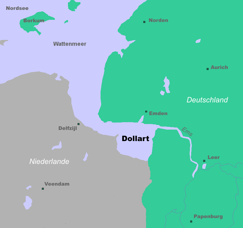
The Dollart (German name) or Dollard (Dutch name) is a bay in the Wadden Sea between the northern Netherlands and Germany, on the west side of the estuary of the Ems river. Most of it dries at low tide. Many water birds feed there. Gaining from and losing to the sea According to legend, the Dollart Bay was created by a catastrophic storm surge in 1277, covering the district of Reiderland and large parts of the Oldambt district. The flood was rumoured to have caused 80,000 deaths. The story, however, is not true and based on legend instead of facts. The Dollart was created as a slow inundation over many centuries which accumulated in a storm surge in 1509. The 1509 surge extended the Dollart, and flooded 30 more villages, and by 1520 the Dollart had its largest extension. Between the 16th and the 20th centuries, two thirds of the drowned area was reclaimed again. Nowadays the unembanked forelands have been declared world natural heritage, as they are a paradise for all k ... [...More Info...] [...Related Items...] OR: [Wikipedia] [Google] [Baidu] |
Nieuweschans
Bad Nieuweschans (also ''Lange Akkeren''; ; Gronings: ''Nij-Schans''; German: ''Bad Neuschanz'') is a village in the north-eastern Netherlands on the border with Germany. It forms part of the municipality of Oldambt. Nieuweschans means "new fortification (sconce)". In 2009, the word Bad ("spa") was prefixed to the name of the village to promote it as a tourist destination. History Bad Nieuwenschans is located in a part of the Dollart which was flooded during the 13th century. In the 1550s, the Dollart was reclaimed by large-scale poldering. In 1626, the area around Oudeschans was poldered, and a settlement appeared in the Nieuwenschans area which was originally called ''Lange Akkeren''. The fortification of Nieuweschans was built in 1628, during the Eighty Years' War. The sconce was a pentagon surrounded by earthen walls and canals. The fortification was still in use during the French occupation. In 1815, the garrison was disbanded, and between 1870 and 1907, the fortificati ... [...More Info...] [...Related Items...] OR: [Wikipedia] [Google] [Baidu] |


.png)


