|
Dreieckiger Pfahl
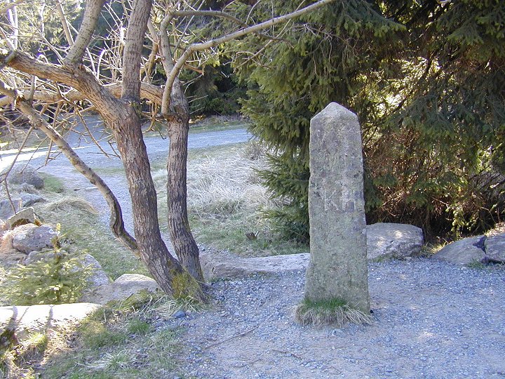
The ''Dreieckige Pfahl'' ("Triangular Post") is a historic boundary stone, about 1.35 metres high and made of granite, located southwest of the Brocken, the highest mountain in the Harz Mountains of central Germany. The stone, erected before 1866, marked the border between the Kingdom of Hanover and the Duchy of Brunswick. Originally this spot was a tripoint. During the division of Germany the border between the German Democratic Republic and the Federal Republic of Germany ran past the ''Dreieckiger Pfahl''. Today it marks the border between the states of Saxony-Anhalt and Lower Saxony, the post lying just within the Lower Saxon side. During the Cold War it was accessible from the west. The historic stone stands at an elevation of about 870 metres, around 2.5 kilometres east of a car park on the B 4 federal road between Torfhaus and Oderbrück. The first recorded mention of a boundary stone being located here dates to the year 1727. On a map of the Upper For ... [...More Info...] [...Related Items...] OR: [Wikipedia] [Google] [Baidu] |
Harz
The Harz () is a highland area in northern Germany. It has the highest elevations for that region, and its rugged terrain extends across parts of Lower Saxony, Saxony-Anhalt, and Thuringia. The name ''Harz'' derives from the Middle High German word ''Hardt'' or ''Hart'' (hill forest). The name ''Hercynia'' derives from a Celtic name and could refer to other mountain forests, but has also been applied to the geology of the Harz. The Brocken is the highest summit in the Harz with an elevation of above sea level. The Wurmberg () is the highest peak located entirely within the state of Lower Saxony. Geography Location and extent The Harz has a length of , stretching from the town of Seesen in the northwest to Eisleben in the east, and a width of . It occupies an area of , and is divided into the Upper Harz (''Oberharz'') in the northwest, which is up to 800 m high, apart from the 1,100 m high Brocken massif, and the Lower Harz (''Unterharz'') in the east which is up to aroun ... [...More Info...] [...Related Items...] OR: [Wikipedia] [Google] [Baidu] |
Harzer Wandernadel
The Harzer Wandernadel is a system of hiking awards in the Harz mountains in central Germany. The hiker (or mountain biker) can earn awards at different levels of challenge by walking to the various checkpoints in the network and stamping his or her passbook to record the visit. With 222 checkpoints in three federal states and across five districts in the Harz and with membership in five figures, the system has gained a following Germany-wide. Purpose The idea of the ''Wandernadel'' (literally "hiking needle/pin" --> "hiking badge") is to give those holidaying in the Harz a worthwhile goal to achieve and encourage them to stay for longer or return. It also aims to encourage those who live in the local area to go hiking and improve their fitness. In addition the system helps tourists and locals to get to know the many different sights and hiking trails in the Harz. To that end, checkpoints have been located at scenic viewing points, places of geological or botanical, culturalbo ... [...More Info...] [...Related Items...] OR: [Wikipedia] [Google] [Baidu] |
Mountain Biker
Mountain biking is a sport of riding bicycles off-road, often over rough terrain, usually using specially designed mountain bikes. Mountain bikes share similarities with other bikes but incorporate features designed to enhance durability and performance in rough terrain, such as air or coil-sprung shocks used as suspension, larger and wider wheels and tires, stronger frame materials, and mechanically or hydraulically actuated disc brakes. Mountain biking can generally be broken down into five distinct categories: cross country, trail riding, all mountain (also referred to as "Enduro"), downhill, and freeride. This sport requires endurance, core strength and balance, bike handling skills, and self-reliance. Advanced riders pursue both steep technical descents and high incline climbs. In the case of freeride, downhill, and dirt jumping, aerial maneuvers are performed off both natural features and specially constructed jumps and ramps. Mountain bikers ride on off-road trails su ... [...More Info...] [...Related Items...] OR: [Wikipedia] [Google] [Baidu] |
Hitler Youth
The Hitler Youth (german: Hitlerjugend , often abbreviated as HJ, ) was the youth organisation of the Nazi Party in Germany. Its origins date back to 1922 and it received the name ("Hitler Youth, League of German Worker Youth") in July 1926. From 1936 until 1945, it was the sole official boys' youth organisation in Germany and it was partially a paramilitary organisation. It was composed of the Hitler Youth proper for male youths aged 14 to 18, and the German Youngsters in the Hitler Youth ( or "DJ", also "DJV") for younger boys aged 10 to 14. With the surrender of Nazi Germany in 1945, the organisation ''de facto'' ceased to exist. On 10 October 1945, the Hitler Youth and its subordinate units were outlawed by the Allied Control Council along with other Nazi Party organisations. Under Section 86 of the Criminal Code of the Federal Republic of Germany, the Hitler Youth is an "unconstitutional organisation" and the distribution or public use of its symbols, except for educ ... [...More Info...] [...Related Items...] OR: [Wikipedia] [Google] [Baidu] |
Wehrmacht
The ''Wehrmacht'' (, ) were the unified armed forces of Nazi Germany from 1935 to 1945. It consisted of the ''Heer'' (army), the ''Kriegsmarine'' (navy) and the ''Luftwaffe'' (air force). The designation "''Wehrmacht''" replaced the previously used term and was the manifestation of the Nazi regime's efforts to rearm Germany to a greater extent than the Treaty of Versailles permitted. After the Nazi rise to power in 1933, one of Adolf Hitler's most overt and audacious moves was to establish the ''Wehrmacht'', a modern offensively-capable armed force, fulfilling the Nazi régime's long-term goals of regaining lost territory as well as gaining new territory and dominating its neighbours. This required the reinstatement of conscription and massive investment and defense spending on the arms industry. The ''Wehrmacht'' formed the heart of Germany's politico-military power. In the early part of the Second World War, the ''Wehrmacht'' employed combined arms tactics (close-cover ... [...More Info...] [...Related Items...] OR: [Wikipedia] [Google] [Baidu] |
Wurmberg (Harz)
At the Wurmberg is the second highest mountain in the Harz and the highest in Lower Saxony (Germany). Geography The Wurmberg lies north of Braunlage, in the district of Landkreis Goslar, Goslar, and west of Schierke. Its Summit (topography), summit is located due south of the Brocken and roughly 400 m (as the crow flies) south of the state border with Saxony-Anhalt. The two mountains are separated by the valley of the Kalte Bode, which in this area is about . Wurmberg nature reserve Until October 2006, the Wurmberg lay within the Upper Harz Nature Reserve (''Naturschutzgebiet Oberharz''). Since then only two areas totalling 183 hectares in area on the west and southwest slopes have been designated as the Wurmberg Nature Reserve. ''Wurmbergklippen'' On the southern flank of the Wurmberg there are two striking tor (rock formation), tors or ''Wurmbergklippen'', which are one of the many ''Harzklippen'': * The ''Große Wurmbergklippe'' (also called the ''Gro� ... [...More Info...] [...Related Items...] OR: [Wikipedia] [Google] [Baidu] |
Run-around Loop
A headshunt (or escape track in the United States) is a short length of track provided to release locomotives at terminal platforms, or to allow shunting to take place clear of main lines. Terminal headshunt A 'terminal headshunt' is a short length of track that allows a locomotive to uncouple from its train, move forward, and then run back past it on a parallel track. Such headshunts are typically installed at a terminal station to allow the locomotive of an arriving train to move to the opposite end of (in railway parlance, 'run around') its train so that it can then haul the same train out of the station in the other direction (assuming, of course, that it is a locomotive equipped to run in either direction; for locomotives that only operate in one direction, a wye or turntable needs to be provided to physically turn the engine around, as well as a run-around track). Reversing headshunt Found primarily on metro systems, rapid transit light rail networks, and tramways, a ' ... [...More Info...] [...Related Items...] OR: [Wikipedia] [Google] [Baidu] |
Schierke
Schierke is a village and a former municipality in the Harz district, in the German state of Saxony-Anhalt. Since 1 July 2009, it is part of the town Wernigerode. Situated within the Harz mountain range in the valley of the river Bode, at the rim of the Harz National Park, it is mainly a tourist resort, especially for hiking and all kinds of winter sports. Geography Location The winter sport and climatic spa of Schierke lies in the High Harz mountains, southeast of their highest summit, the Brocken. It is situated in the Harz/Saxony-Anhalt Nature Park and borders on the Harz National Park in the north. Situated 600 to 650 m above sea level in the valley of the Cold Bode, the parish of Schierke has an area of 40.1 km² and a population of 713 (as at 31 December 2007). Today Schierke again is a popular place to start or finish a walk to the Brocken massif via the '' Goetheweg'' or the ''Glashüttenweg''. It has bus service and access to the Brocken Railway, whose s ... [...More Info...] [...Related Items...] OR: [Wikipedia] [Google] [Baidu] |
South Harz Railway
The South Harz Railway (german: Südharzstrecke or ''Südharzbahn'') is a railway line through the German states of Lower Saxony and Thuringia. It runs from Northeim to Nordhausen, via Herzberg am Harz, Bad Lauterberg-Barbis, Bad Sachsa, Walkenried and Ellrich. The line is long. Route The South Harz line runs roughly east–west, with Northeim lying further north than Nordhausen. It runs from the Leine valley along the Rhume and the Oder (Harz) rivers with normal grades through Katlenburg-Lindau to Herzberg am Harz. From there it rises on a grade of up to 1.06% through Scharzfeld and Barbis to the former station of Osterhagen, the highest point of the line. The line falls gently and runs south of Bad Sachsa to Walkenried. To the east is the only tunnel on the line, connecting to the valley of the Zorge. Shortly after the tunnel is the border of Lower Saxony and Thuringia, the former Inner German border. From Ellrich the line follows the Zorge to Nordhausen. The Harz Railway ('' ... [...More Info...] [...Related Items...] OR: [Wikipedia] [Google] [Baidu] |
Braunlage
Braunlage () is a town and health resort in the Goslar district of Lower Saxony in Germany. Situated within the Harz mountain range, south of the Brocken massif, Braunlage's main business is tourism, particularly skiing. Nearby ski resorts include the Sonnenberg and the slopes on the Wurmberg. Geography Braunlage is located on the Warme Bode, a headstream of the river Bode, close to the border with Elend in the state of Saxony-Anhalt. The municipal area stretches along the south-eastern rim of the Harz National Park from an elevation of up to at the summit of the Wurmberg. Other peaks in the vicinity include the Achtermannshöhe and the Hahnenklee Crags. Districts The town consists of three districts: * Braunlage proper * Hohegeiß*, incorporated on 1 July 1972 * Sankt Andreasberg**, incorporated on 1 November 2011 * with the village of Königskrug ** with the villages of Sonnenberg, Oderhaus, Oderbrück, Oderberg, Odertaler Sägemühle and Silberhütte Transportation ... [...More Info...] [...Related Items...] OR: [Wikipedia] [Google] [Baidu] |


