|
Dreadnought Point
Dreadnought Point () is a prominent rocky point on the west side of Croft Bay, James Ross Island. It was surveyed by the Falkland Islands Dependencies Survey in August 1953. The UK Antarctic Place-Names Committee name is descriptive; the appearance of the feature is reminiscent of the bows of the early ironclads (battleships), also known as "dreadnought The dreadnought (alternatively spelled dreadnaught) was the predominant type of battleship in the early 20th century. The first of the kind, the Royal Navy's , had such an impact when launched in 1906 that similar battleships built after her ...s". References Headlands of James Ross Island {{JamesRossIsland-geo-stub ... [...More Info...] [...Related Items...] OR: [Wikipedia] [Google] [Baidu] |
Croft Bay
Croft Bay () is a bay which indents the north-central side of James Ross Island and forms the southern part of Herbert Sound, south of the northeastern end of the Antarctic Peninsula. It was discovered in 1903 by the Swedish Antarctic Expedition under Otto Nordenskiöld. It was charted in 1945 by the Falkland Islands Dependencies Survey (FIDS), who named it for W.N. Croft, a FIDS geologist at Hope Bay Hope Bay (Spanish: ''Bahía Esperanza'') on Trinity Peninsula, is long and wide, indenting the tip of the Antarctic Peninsula and opening on Antarctic Sound. It is the site of the Argentinian Antarctic settlement Esperanza Base, established i ... in 1946. References * Bays of James Ross Island {{JamesRossIsland-geo-stub ... [...More Info...] [...Related Items...] OR: [Wikipedia] [Google] [Baidu] |
James Ross Island
James Ross Island is a large island off the southeast side and near the northeastern extremity of the Antarctic Peninsula, from which it is separated by Prince Gustav Channel. Rising to , it is irregularly shaped and extends in a north–south direction. It was charted in October 1903 by the Swedish Antarctic Expedition under Otto Nordenskiöld, who named it for Sir James Clark Ross, the leader of a British expedition to this area in 1842 that discovered and roughly charted a number of points along the eastern side of the island. The style, "James" Ross Island is used to avoid confusion with the more widely known Ross Island in McMurdo Sound. It is one of several islands around the peninsula known as Graham Land, which is closer to South America than any other part of that continent. The island was connected to the Antarctic mainland by an ice shelf until 1995, when the ice shelf collapsed, making the Prince Gustav Channel passable for the first time. Mendel Polar Station, t ... [...More Info...] [...Related Items...] OR: [Wikipedia] [Google] [Baidu] |
Falkland Islands Dependencies Survey
The British Antarctic Survey (BAS) is the United Kingdom's national polar research institute. It has a dual purpose, to conduct polar science, enabling better understanding of global issues, and to provide an active presence in the Antarctic on behalf of the UK. It is part of the Natural Environment Research Council (NERC). With over 400 staff, BAS takes an active role in Antarctic affairs, operating five research stations, one ship and five aircraft in both polar regions, as well as addressing key global and regional issues. This involves joint research projects with over 40 UK universities and more than 120 national and international collaborations. Having taken shape from activities during World War II, it was known as the Falkland Islands Dependencies Survey until 1962. History Operation Tabarin was a small British expedition in 1943 to establish permanently occupied bases in the Antarctic. It was a joint undertaking by the Admiralty and the Colonial Office. At the end of t ... [...More Info...] [...Related Items...] OR: [Wikipedia] [Google] [Baidu] |
UK Antarctic Place-Names Committee
The UK Antarctic Place-Names Committee (or UK-APC) is a United Kingdom government committee, part of the Foreign and Commonwealth Office, responsible for recommending names of geographical locations within the British Antarctic Territory (BAT) and the South Georgia and the South Sandwich Islands (SGSSI). Such names are formally approved by the Commissioners of the BAT and SGSSI respectively, and published in the BAT Gazetteer and the SGSSI Gazetteer maintained by the Committee. The BAT names are also published in the international Composite Gazetteer of Antarctica maintained by Scientific Committee on Antarctic Research, SCAR. The Committee may also consider proposals for new place names for geographical features in areas of Antarctica outside BAT and SGSSI, which are referred to other Antarctic place-naming authorities, or decided by the Committee itself if situated in the unclaimed sector of Antarctica. Names attributed by the committee * Anvil Crag, named for descriptive featu ... [...More Info...] [...Related Items...] OR: [Wikipedia] [Google] [Baidu] |
Dreadnought
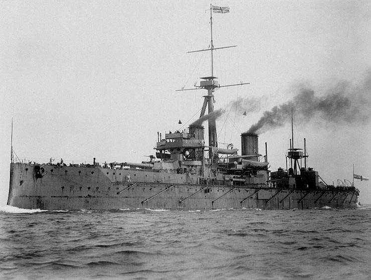
The dreadnought (alternatively spelled dreadnaught) was the predominant type of battleship in the early 20th century. The first of the kind, the Royal Navy's , had such an impact when launched in 1906 that similar battleships built after her were referred to as "dreadnoughts", and earlier battleships became known as pre-dreadnoughts. Her design had two revolutionary features: an "all-big-gun" armament scheme, with an unprecedented number of heavy-calibre guns, and steam turbine propulsion. As dreadnoughts became a crucial symbol of national power, the arrival of these new warships renewed the naval arms race between the United Kingdom and Germany. Dreadnought races sprang up around the world, including in South America, lasting up to the beginning of World War I. Successive designs increased rapidly in size and made use of improvements in armament, armour and propulsion throughout the dreadnought era. Within five years, new battleships outclassed ''Dreadnought'' herself. Th ... [...More Info...] [...Related Items...] OR: [Wikipedia] [Google] [Baidu] |

.jpg)
