|
Dougherty Island
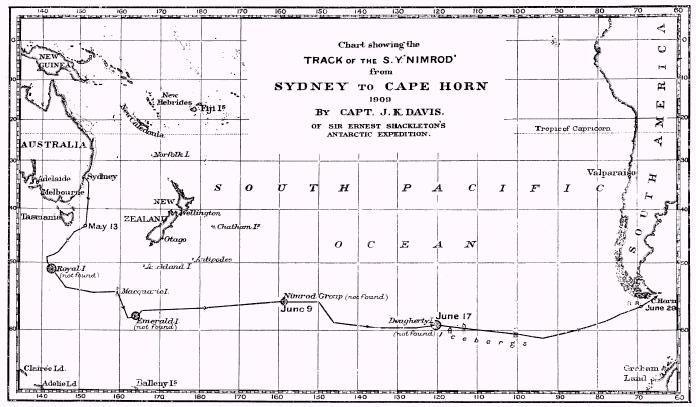
Dougherty is the name of a phantom island A phantom island is a purported island which was included on maps for a period of time, but was later found not to exist. They usually originate from the reports of early sailors exploring new regions, and are commonly the result of navigati ... that was believed to be located in the extreme south of the Pacific Ocean, roughly halfway between Cape Horn and New Zealand. It is named for Captain Dougherty of the ''James Stewart'', an English whaler, who in 1841 reported discovering it at . He described it as 5–6 miles long with a high bluff to the northeast and covered in snow. Dougherty's discovery was confirmed by Captain Keates of the ''Louise'' in 1860, giving its coordinates as , and by Captain Stannard of the ''Cingalese'' in 1886, giving the location as . However, thorough exploration of the area in the late 19th and early 20th centuries established that the island does not exist. Captain Davis of the '' Nimrod'' suggeste ... [...More Info...] [...Related Items...] OR: [Wikipedia] [Google] [Baidu] |
Nimrod
Nimrod (; ; arc, ܢܡܪܘܕ; ar, نُمْرُود, Numrūd) is a biblical figure mentioned in the Book of Genesis and Books of Chronicles. The son of Cush and therefore a great-grandson of Noah, Nimrod was described as a king in the land of Shinar (Mesopotamia). The Bible states that he was "a mighty hunter before the Lord nd... began to be mighty in the earth". Later extra-biblical traditions identified Nimrod as the ruler who commissioned the construction of the Tower of Babel, which led to his reputation as a king who was rebellious against God. Nimrod has not been attested in any historic, non-biblical registers, records or king lists, including those of Mesopotamia itself. Historians have failed to match Nimrod with any historically attested figure. Several ruins of the Middle East have been named after him. Biblical account The first biblical mention of Nimrod is in the Table of Nations. He is described as the son of Cush, grandson of Ham, son of Noah, Ham, and g ... [...More Info...] [...Related Items...] OR: [Wikipedia] [Google] [Baidu] |
Antarctica Map
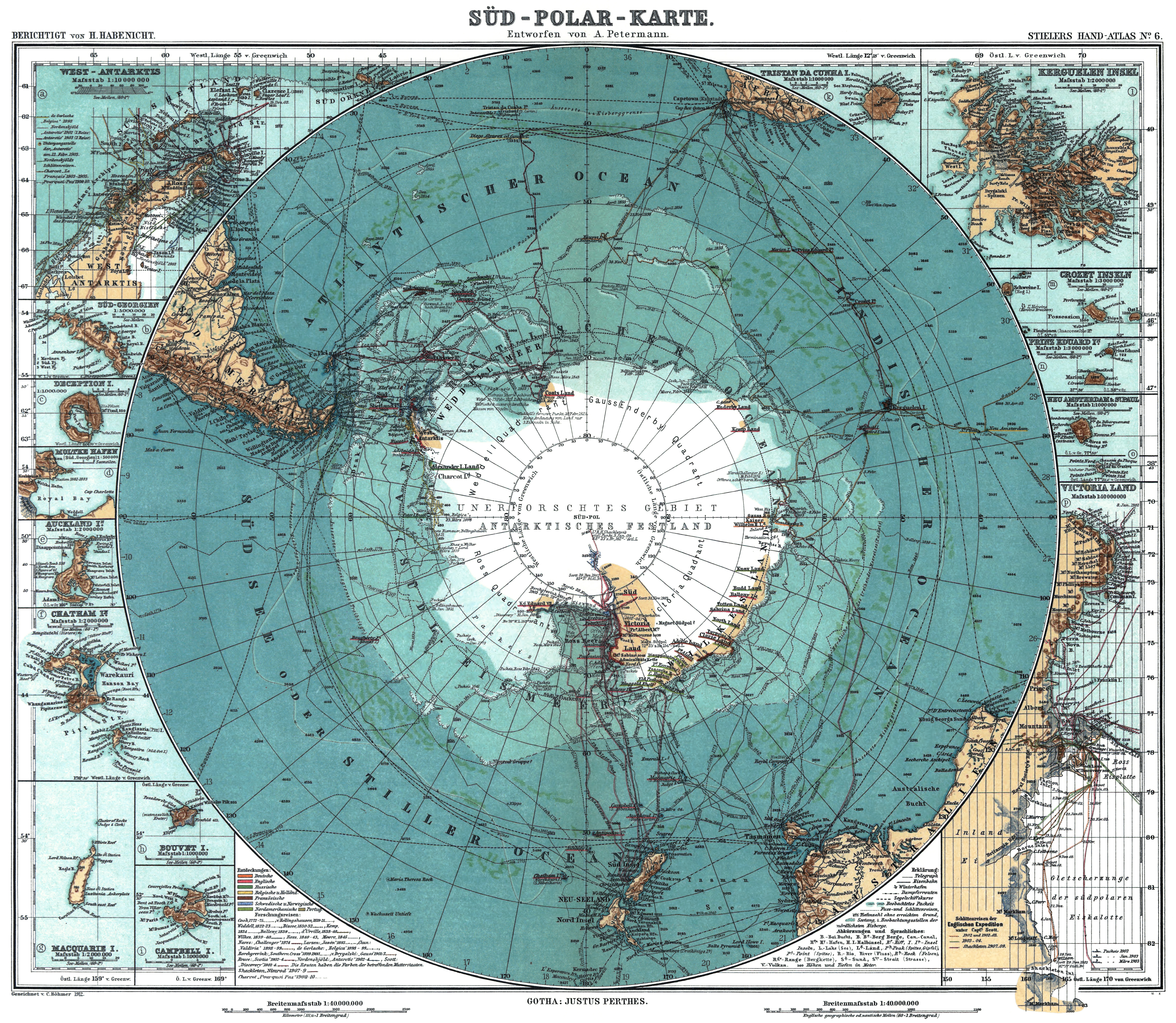
Antarctica () is Earth's southernmost and least-populated continent. Situated almost entirely south of the Antarctic Circle and surrounded by the Southern Ocean, it contains the geographic South Pole. Antarctica is the fifth-largest continent, being about 40% larger than Europe, and has an area of . Most of Antarctica is covered by the Antarctic ice sheet, with an average thickness of . Antarctica is, on average, the coldest, driest, and windiest of the continents, and it has the highest average elevation. It is mainly a polar desert, with annual precipitation of over along the coast and far less inland. About 70% of the world's freshwater reserves are frozen in Antarctica, which, if melted, would raise global sea levels by almost . Antarctica holds the record for the lowest measured temperature on Earth, . The coastal regions can reach temperatures over in summer. Native species of animals include mites, nematodes, penguins, seals and tardigrades. Where vegetation occur ... [...More Info...] [...Related Items...] OR: [Wikipedia] [Google] [Baidu] |
Phantom Island
A phantom island is a purported island which was included on maps for a period of time, but was later found not to exist. They usually originate from the reports of early sailors exploring new regions, and are commonly the result of navigational errors, mistaken observations, unverified misinformation, or deliberate fabrication. Some have remained on maps for centuries before being "un-discovered." Unlike lost lands, which are claimed (or known) to have once existed but to have been swallowed by the sea or otherwise destroyed, a phantom island is one that is claimed to exist contemporaneously, but later found not to have existed in the first place (or found not to be an island, as with the Island of California). Examples Some may have been purely mythical, such as the Isle of Demons near Newfoundland, which may have been based on local legends of a haunted island. The far-northern island of Thule was reported to exist by 4th century BCE Greek explorer Pytheas, but informati ... [...More Info...] [...Related Items...] OR: [Wikipedia] [Google] [Baidu] |
Pacific Ocean
The Pacific Ocean is the largest and deepest of Earth's five oceanic divisions. It extends from the Arctic Ocean in the north to the Southern Ocean (or, depending on definition, to Antarctica) in the south, and is bounded by the continents of Asia and Oceania in the west and the Americas in the east. At in area (as defined with a southern Antarctic border), this largest division of the World Ocean—and, in turn, the hydrosphere—covers about 46% of Earth's water surface and about 32% of its total surface area, larger than Earth's entire land area combined .Pacific Ocean . '' Britannica Concise.'' 2008: Encyclopædia Britannica, Inc. The centers of both the |
Cape Horn
Cape Horn ( es, Cabo de Hornos, ) is the southernmost headland of the Tierra del Fuego archipelago of southern Chile, and is located on the small Hornos Island. Although not the most southerly point of South America (which are the Diego Ramírez Islands), Cape Horn marks the northern boundary of the Drake Passage and marks where the Atlantic and Pacific Oceans meet. Cape Horn was identified by mariners and first rounded in 1616 by the Dutchman Willem Schouten and Jacob Le Maire, who named it after the city of Hoorn in the Netherlands. For decades, Cape Horn was a major milestone on the clipper route, by which sailing ships carried trade around the world. The waters around Cape Horn are particularly hazardous, owing to strong winds, large waves, strong currents and icebergs. The need for boats and ships to round Cape Horn was greatly reduced by the opening of the Panama Canal in August 1914. Sailing around Cape Horn is still widely regarded as one of the major challenges in y ... [...More Info...] [...Related Items...] OR: [Wikipedia] [Google] [Baidu] |
New Zealand
New Zealand ( mi, Aotearoa ) is an island country in the southwestern Pacific Ocean. It consists of two main landmasses—the North Island () and the South Island ()—and over 700 smaller islands. It is the sixth-largest island country by area, covering . New Zealand is about east of Australia across the Tasman Sea and south of the islands of New Caledonia, Fiji, and Tonga. The country's varied topography and sharp mountain peaks, including the Southern Alps, owe much to tectonic uplift and volcanic eruptions. New Zealand's capital city is Wellington, and its most populous city is Auckland. The islands of New Zealand were the last large habitable land to be settled by humans. Between about 1280 and 1350, Polynesians began to settle in the islands and then developed a distinctive Māori culture. In 1642, the Dutch explorer Abel Tasman became the first European to sight and record New Zealand. In 1840, representatives of the United Kingdom and Māori chiefs ... [...More Info...] [...Related Items...] OR: [Wikipedia] [Google] [Baidu] |
John King Davis
John King Davis (19 February 1884 – 8 May 1967) was an English-born Australian explorer and navigator notable for his work captaining exploration ships in Antarctic waters as well as for establishing meteorological stations on Macquarie Island in the subantarctic and on Willis Island in the Coral Sea. Early life Davis's formal education, at Colet Court, London, and at Burford Grammar School, Oxfordshire, ended in 1900, when he and his father left London for Cape Town, South Africa. Career Early exploration work Davis served as chief officer of the during Ernest Shackleton's Antarctic expedition in 1908–1909. He was captain of the and second in command of Douglas Mawson's Australasian Antarctic expedition in 1911–1914. First World War At the outbreak of World War I in August 1914, Davis volunteered for active service, and was put in charge of the troop transport , carrying troops and horses to Egypt and England. Later exploration work He also served as C ... [...More Info...] [...Related Items...] OR: [Wikipedia] [Google] [Baidu] |
Nimrod (ship)
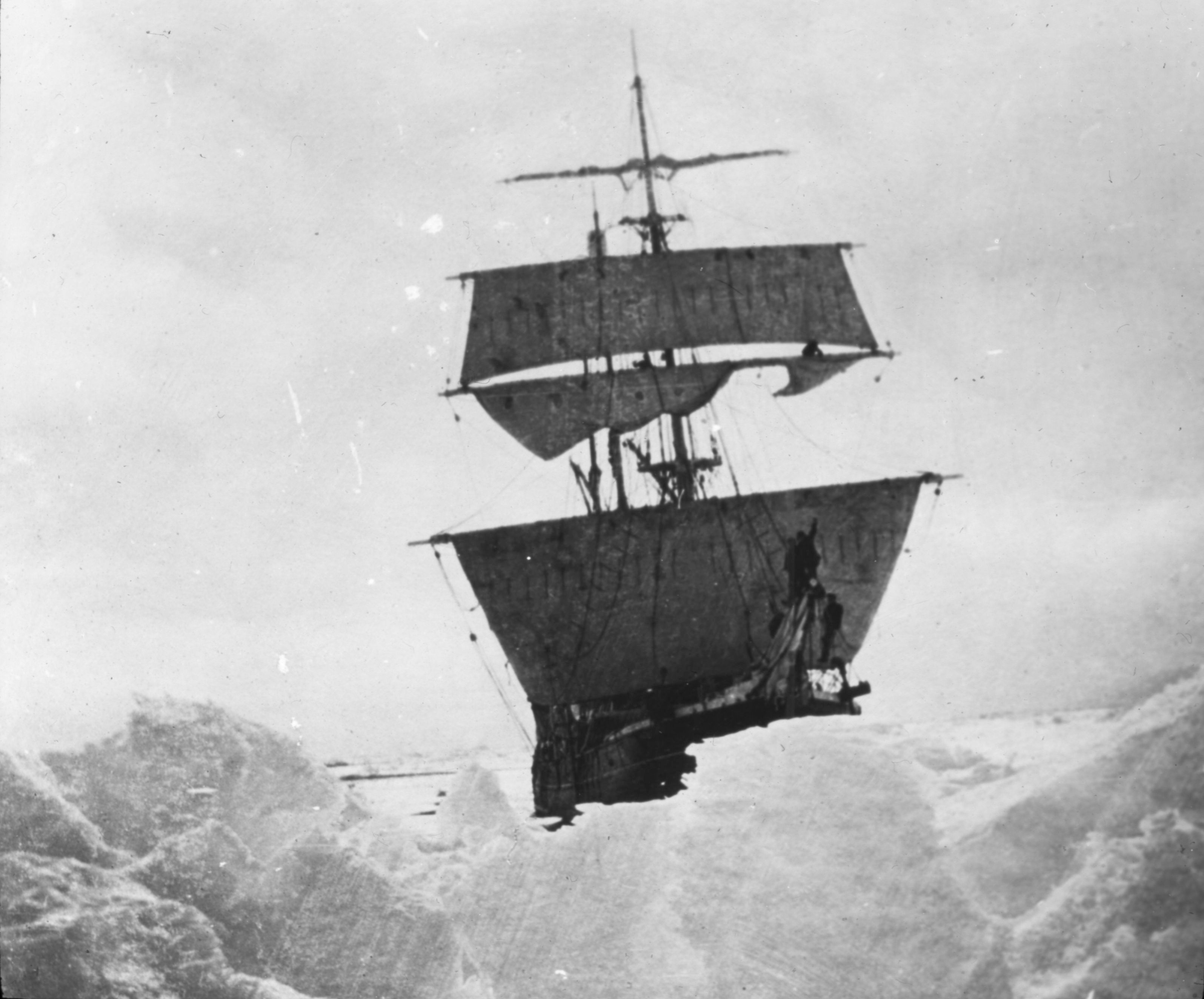
''Nimrod'' was a wooden-hulled, three-masted sailing ship with auxiliary steam engine that was built in Scotland in 1867 as a whaler. She was the ship with which Ernest Shackleton made his ''Nimrod'' Expedition to Antarctica in 1908–09. After the expedition she returned to commercial service, and in 1919 she was wrecked in the North Sea with the loss of ten members of her crew. Building and registration Alexander Stephen and Sons built ''Nimrod'' in Dundee. Her launch date is not recorded, but she was completed in January 1867. Her registered length was , her beam was and her depth was . Her tonnages were and . She was rigged as a schooner. She had a single screw, driven by a 50 hp steam engine built by Gourlay Brothers of Dundee. Her principal owner was Thomas B Job, who registered her at Liverpool. Her United Kingdom official number was 55047. They used her for whaling and seal hunting. By 1874 ''Nimrod'' was rigged as a barquentine. By 1888 her owners were listed as J ... [...More Info...] [...Related Items...] OR: [Wikipedia] [Google] [Baidu] |
Royal Company's Islands
The Royal Company's Islands are a group of phantom islands reported by some early explorers to lie southwest of Tasmania. They were first heard of before 1840, but the original report cannot be traced. Many old charts show them at or . The islands' existence was disproved as early as 1840 by the United States Exploring Expedition. From 1889 to 1902 several vessels passed through the islands' vicinity without noting any landforms, and in 1904 the UK Hydrographic Office finally decided to remove them from all Admiralty charts. In October 1894 the 'Antarctic' ( H. Bull's exploratory whaling expedition sponsored by Svend Foyn) steered for the Royal Company's Islands "supposed to be situated in about lat. 51 degrees S,. and long. 142 E." They searched for a couple of days, but met with gales. Not finding any islands, they headed for Macquarie Island. Further searches by the '' Nimrod'' in 1909 and the '' Aurora'' in 1912 turned up nothing. See also * Emerald Island (phantom ... [...More Info...] [...Related Items...] OR: [Wikipedia] [Google] [Baidu] |
Emerald Island (phantom)
The Emerald Island is a phantom island reported to lie between Australia and Antarctica and south of Macquarie Island. It was first sighted by the British sealing ship ''Emerald'', captained by William Elliot, in December 1821,Headland, Robert (1989)Chronological list of Antarctic expeditions and related historical events p. 123. Cambridge University Press. . and the name of the supposed island is derived from the name of this ship. It was presumed to be a small (but high and mountainous) island located at . No trace of the island was found by the 1840 United States Exploring Expedition. Although a captain visiting Port Chalmers reported seeing it sometime before 1890, a search by the '' Nimrod'' in 1909 turned up nothing. Nevertheless, it appeared on a map as late as 1987 in a desk calendar book (with atlas) published by American Express. The abyssal plain on the ocean floor beneath the supposed location of this phantom island is named Emerald Basin. See also * Royal Comp ... [...More Info...] [...Related Items...] OR: [Wikipedia] [Google] [Baidu] |
Nimrod Islands
The Nimrod Islands were a group of islands first reported in 1828 by Captain Eilbeck of the ship ''Nimrod'' while sailing from Port Jackson around Cape Horn. Their reported location was east of Emerald Island and west of Dougherty Island, at approximately . They are now considered phantom islands. The explorer John Biscoe in the brig ''Tula'' searched for the Nimrod Group without success in 1831 during the Southern Ocean Expedition. John King Davis, sailing aboard a different '' Nimrod'', searched the location in June 1909 following Shackleton's famous Nimrod Expedition to Antarctica, and the Norwegian vessel ''Norvegia'' outfitted by Lars Christensen searched again in 1930; both expeditions reported empty seas. Captain J.P. Ault of the magnetic survey vessel '' Carnegie'' attempted to approach the location in December 1915 but was deterred by weather. See also * 1906 German map showing Nimrod Group * Royal Company's Islands * Emerald Island (phantom) * Dougherty Island ... [...More Info...] [...Related Items...] OR: [Wikipedia] [Google] [Baidu] |
Sandy Island, New Caledonia
Sandy Island (sometimes labelled in French , and in Spanish ) is a non-existent island that was charted for over a century as being located near the French territory of New Caledonia between the Chesterfield Islands and Nereus Reef in the eastern Coral Sea. The island was included on many maps and nautical charts from as early as the late 19th century. It was removed from French hydrographic charts in 1974. The island gained wide media and public attention in November 2012 when the R/V ''Southern Surveyor'', an Australian research ship, passed through the area and "undiscovered" it. The island was quickly removed from many maps and data sets, including those of the National Geographic Society and Google Maps. History On 14–15 September 1774, Captain James Cook charted a "Sandy I." snaking between 19°–20° S latitudes and 163°50'–164°15' E longitude off the tip of New Caledonia. The associated map, titled "Chart of Discoveries made in the South Paci ... [...More Info...] [...Related Items...] OR: [Wikipedia] [Google] [Baidu] |

.jpg)


.jpg)


