|
Djenné (24)
Djenné ( bm, ߖߍ߬ߣߍ߫, italics=no, Jɛ̀nɛ́; also known as Djénné, Jenné, and Jenne) is a Songhai town and urban commune in the Inland Niger Delta region of central Mali. The town is the administrative centre of the Djenné Cercle, one of the eight subdivisions of the Mopti Region. The commune includes ten of the surrounding villages and in 2009 had a population of 32,944. The history of Djenné is closely linked with that of Timbuktu. Between the 15th and 17th centuries much of the trans-Saharan trade in goods such as salt, gold, and slaves that moved in and out of Timbuktu passed through Djenné. Both towns became centres of Islamic scholarship. Djenné's prosperity depended on this trade and when the Portuguese established trading posts on the African coast, the importance of the trans-Saharan trade and thus of Djenné declined. The town is famous for its distinctive adobe architecture, most notably the Great Mosque which was built in 1907 on the site of an e ... [...More Info...] [...Related Items...] OR: [Wikipedia] [Google] [Baidu] |
Koyra Chiini Language
Koyra Chiini (, figuratively "town language"), or Western Songhay, is a member of the Songhay languages spoken in Mali by about 200,000 people (in 1999) along the Niger River in Timbuktu and upriver from it in the towns of Diré, Tonka, Goundam and Niafunké as well as in the Saharan town of Araouane to its north. In this area, Koyra Chiini is the dominant language and the ''lingua franca'', although minorities speaking Hassaniya Arabic, Tamasheq and Fulfulde are found. Djenné Chiini , the dialect spoken in Djenné, is mutually comprehensible, but has noticeable differences, in particular two extra vowels ( and ) and syntactic differences related to focalisation. East of Timbuktu, Koyra Chiini gives way relatively abruptly to another Songhay language, Koyraboro Senni. Unlike most Songhai languages, Koyra Chiini has no phonemic tones and has subject–verb–object word order rather than subject–object–verb Subject ( la, subiectus "lying beneath") may refer to ... [...More Info...] [...Related Items...] OR: [Wikipedia] [Google] [Baidu] |
Bamako
Bamako ( bm, ߓߡߊ߬ߞߐ߬ ''Bàmakɔ̌'', ff, 𞤄𞤢𞤥𞤢𞤳𞤮 ''Bamako'') is the Capital city, capital and largest city of Mali, with a 2009 population of 1,810,366 and an estimated 2022 population of 2.81 million. It is located on the Niger River, near the rapids that divide the upper and middle Niger valleys in the southwestern part of the country. Bamako is the nation's administrative centre. The city proper is a Cercles of Mali, cercle in its own right. Bamako's Inland port, river port is located in nearby Koulikoro, along with a major regional trade and conference center. Bamako is the seventh-largest West Africa, West African urban center after Lagos, Abidjan, Kano (city), Kano, Ibadan, Dakar, and Accra. Locally manufactured goods include textiles, processed meat, and metal goods as well as mining. Commercial fishing occurs on the Niger River. The name Bamako ( ''Bàmakɔ̌'' in Bambara language, Bambara) comes from the Bambara word meaning "crocodile river". ... [...More Info...] [...Related Items...] OR: [Wikipedia] [Google] [Baidu] |
René Caillié
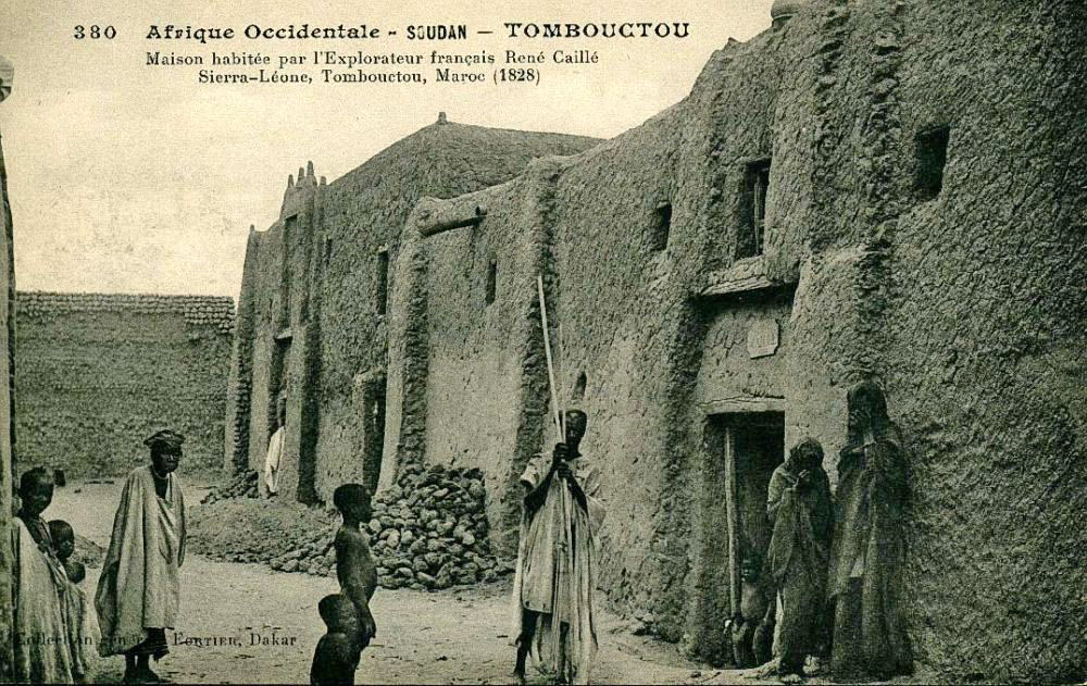
Auguste René Caillié (; 19 November 1799 – 17 May 1838) was a French explorer and the first European to return alive from the town of Timbuktu. Caillié had been preceded at Timbuktu by a British officer, Major Gordon Laing, who was murdered in September 1826 on leaving the city. Caillié was therefore the first to return alive. Caillié was born in western France in a village near the port of Rochefort. His parents were poor and died while he was still young. At the age of 16 he left home and signed up as a member of the crew on a French naval vessel sailing to Saint-Louis on the coast of modern Senegal in western Africa. He stayed there for several months and then crossed the Atlantic to Guadeloupe on a merchantman. He made a second visit to West Africa two years later when he accompanied a British expedition across the Ferlo Desert to Bakel on the Senegal River. Caillié returned to Saint-Louis in 1824 with a strong desire to become an explorer and visit Timbuktu. In ... [...More Info...] [...Related Items...] OR: [Wikipedia] [Google] [Baidu] |
Harmattan
The Harmattan is a season in West Africa that occurs between the end of November and the middle of March. It is characterized by the dry and dusty northeasterly trade wind, of the same name, which blows from the Sahara over West Africa into the Gulf of Guinea. The name is related to the word in the Twi language. The temperature is cold in most places, but can also be hot in certain places, depending on local circumstances. The Harmattan blows during the dry season, which occurs during the months with the lowest sun. In this season the subtropical ridge of high pressure stays over the central Sahara and the low-pressure Intertropical Convergence Zone (ITCZ) stays over the Gulf of Guinea. On its passage over the Sahara, the Harmattan picks up fine dust and sand particles (between 0.5 and 10 microns). It is also known as the "doctor wind", because of its invigorating dryness compared with humid tropical air. Effects This season differs from winter, because it is characterized ... [...More Info...] [...Related Items...] OR: [Wikipedia] [Google] [Baidu] |
Chef-lieu
An administrative center is a seat of regional administration or local government, or a county town, or the place where the central administration of a commune is located. In countries with French as administrative language (such as Belgium, Luxembourg, Switzerland and many African countries), a (, plural form , literally 'chief place' or 'main place'), is a town or city that is important from an administrative perspective. Algeria The capital of an Algerian province is called a chef-lieu. The capital of a district, the next largest division, is also called a chef-lieu, whilst the capital of the lowest division, the municipalities, is called agglomération de chef-lieu (chef-lieu agglomeration) and is abbreviated as A.C.L. Belgium The chef-lieu in Belgium is the administrative centre of each of the ten provinces of Belgium. Three of these cities also give their name to their province (Antwerp, Liège and Namur). France The chef-lieu of a département is known as the ''préfec ... [...More Info...] [...Related Items...] OR: [Wikipedia] [Google] [Baidu] |
Pondori
Pondori is a commune of the Cercle of Djenné in the Mopti Region of Mali. The principal village lies at Gomitogo Gomitogo is a village and seat of the commune of Pondori in the Cercle of Djenné in the Mopti Region of southern-central Mali Mali (; ), officially the Republic of Mali,, , ff, 𞤈𞤫𞤲𞥆𞤣𞤢𞥄𞤲𞤣𞤭 𞤃𞤢𞥄𞤤 .... The commune also includes the villages of Koba, Kobassa, Siroumou, Noina and Djera. In the census of 2009 the commune had a population of 4,315, a substantially lower value than the population of 7,748 recorded in the 1998 census. References External links *. Communes of Mopti Region {{Mopti-geo-stub ... [...More Info...] [...Related Items...] OR: [Wikipedia] [Google] [Baidu] |
Madiama
Madiama is a rural commune and village in the Cercle of Djenné in the Mopti Region of Mali. The commune contains ten villages. The commune lies to the west of the main RN6 highway linking Bamako with Gao and is crossed by the spur road linking the highway with the Djenné ferry across the Bani River The Bani River is the principal tributary of the Niger River in Mali. The river is formed from the confluence of the Baoulé and Bagoé rivers some east of Bamako and it merges with the Niger near Mopti. Its length is about . Geography Th .... The commune is bounded on its west side by the urban commune of Djenné and the commune of Dandougou Fakala.. The report includes low resolution maps obtained from screen-dumps which show the boundaries of communes within the Djenné Cercle. References Communes of Mopti Region {{Mopti-geo-stub ... [...More Info...] [...Related Items...] OR: [Wikipedia] [Google] [Baidu] |
Fakala
Fakala is a Rural Commune of the Cercle of Djenné in the Mopti Region of Mali Mali (; ), officially the Republic of Mali,, , ff, 𞤈𞤫𞤲𞥆𞤣𞤢𞥄𞤲𞤣𞤭 𞤃𞤢𞥄𞤤𞤭, Renndaandi Maali, italics=no, ar, جمهورية مالي, Jumhūriyyāt Mālī is a landlocked country in West Africa. Mal .... The commune contains 30 villages. and had a population of 32,689 in the census of 2009. The local government is based in the small town of Sofara. References External links *. Communes of Mopti Region {{Mopti-geo-stub ... [...More Info...] [...Related Items...] OR: [Wikipedia] [Google] [Baidu] |
Dandougou Fakala
Dandougou Fakala is a rural commune in the Cercle of Djenné in the Mopti Region of Mali. The commune contains ten villages. The administrative center (''chef-lieu An administrative center is a seat of regional administration or local government, or a county town, or the place where the central administration of a commune is located. In countries with French as administrative language (such as Belgium, Lu ...'') is the village of Konio.. In the 2009 census the commune had a population of 9,841. References External links *. Communes of Mopti Region {{Mopti-geo-stub ... [...More Info...] [...Related Items...] OR: [Wikipedia] [Google] [Baidu] |
Derary
Derary is a rural commune of the Cercle of Djenné in the Mopti Region of Mali. The commune contains eight villages.. The administrative center (''chef-lieu An administrative center is a seat of regional administration or local government, or a county town, or the place where the central administration of a commune is located. In countries with French as administrative language (such as Belgium, Lu ...'') is the village of Gagna. In the 2009 census the commune had a population of 6,558. References Communes of Mopti Region {{Mopti-geo-stub ... [...More Info...] [...Related Items...] OR: [Wikipedia] [Google] [Baidu] |
Ouro Ali
Ouro Ali is a rural commune of the Cercle of Djenné in the Mopti Region of Mali. The commune includes the villages of Senossa, Koloye, Ouro Djikoye, Siratintin, Weraka, Wono, Kotola, Djimatogo, Ali Samba, Kandia and Somena.. The administrative center (''chef-lieu An administrative center is a seat of regional administration or local government, or a county town, or the place where the central administration of a commune is located. In countries with French as administrative language (such as Belgium, Lu ...'') is the village of Senossa. In the census of 2009 the commune had a population of 10,354. References Communes of Mopti Region {{Mopti-geo-stub ... [...More Info...] [...Related Items...] OR: [Wikipedia] [Google] [Baidu] |
.jpg)


_(10004827914).jpg)