|
Dingle Peninsula
The Dingle Peninsula ( ga, Corca Dhuibhne; anglicised as Corkaguiny, the name of the corresponding barony) is the northernmost of the major peninsulas in County Kerry. It ends beyond the town of Dingle at Dunmore Head, the westernmost point of Ireland and arguably Europe. Name The Dingle Peninsula is named after the town of Dingle. The peninsula is also commonly called ''Corca Dhuibhne'' ( Corcu Duibne) even when those referring to it are speaking in English. ''Corca Dhuibhne'', which means "seed or tribe of Duibhne" (a Goddess, a Gaelic clan name), takes its name from the ''túath'' (people, nation) of ''Corco Dhuibhne'' who occupied the peninsula in the Middle Ages and who also held a number of territories in the south and east of County Kerry. Geography The peninsula exists because of the band of sandstone rock that forms the Slieve Mish mountain range at the neck of the peninsula, in the east, and the Brandon Group of mountains, and the Mountains of the Central Dingle ... [...More Info...] [...Related Items...] OR: [Wikipedia] [Google] [Baidu] |
Ireland
Ireland ( ; ga, Éire ; Ulster Scots dialect, Ulster-Scots: ) is an island in the Atlantic Ocean, North Atlantic Ocean, in Northwestern Europe, north-western Europe. It is separated from Great Britain to its east by the North Channel (Great Britain and Ireland), North Channel, the Irish Sea, and St George's Channel. Ireland is the List of islands of the British Isles, second-largest island of the British Isles, the List of European islands by area, third-largest in Europe, and the List of islands by area, twentieth-largest on Earth. Geopolitically, Ireland is divided between the Republic of Ireland (officially Names of the Irish state, named Ireland), which covers five-sixths of the island, and Northern Ireland, which is part of the United Kingdom. As of 2022, the Irish population analysis, population of the entire island is just over 7 million, with 5.1 million living in the Republic of Ireland and 1.9 million in Northern Ireland, ranking it the List of European islan ... [...More Info...] [...Related Items...] OR: [Wikipedia] [Google] [Baidu] |
Slieve Mish Mountains
, translation = ossiblymountains of Mis , language = Irish , photo=File:Fenit Marina Ireland.JPG , photo_caption= Slieve Mish Mountains from across the Tralee Bay in the village of Fenit , country=Republic of Ireland , location = Kerry , region = Munster , region_type = Provinces of Ireland , parent= , border= , length_km = 19 , length_orientation = East–West , width_km = 6 , area_km2 = 97.9 , width_orientation= , highest=Baurtregaum , elevation_m=851 , elevation_ref = , coordinates = , range_coordinates = , orogeny = , map=island of Ireland , map_caption=Location of Slieve Mish Mountains , geology= Purple cross-bedded sandstone , period= Devonian , topo = OSI ''Discovery'' 71 Slieve Mish Mountains (), is a predominantly sandstone mountain range at the eastern end of the Dingle Peninsula in County Kerry, Ireland. Stretching , from the first major peak of Barnanageehy outside of Tralee in the east, to Cnoc na Stuaice in near Central Dingle ... [...More Info...] [...Related Items...] OR: [Wikipedia] [Google] [Baidu] |
Dún Chaoin
Dunquin ( ) is a Gaeltacht village in west County Kerry, Ireland. Dunquin lies at the most westerly tip of the Dingle Peninsula, overlooking the Blasket Islands. At 10°27'16"W, it is the most westerly settlement of Ireland and of Eurasia, excluding Iceland. Nearby Dunmore Head is the most westerly point of mainland Ireland. The town is linked to Dingle via the R559 regional road. In summer a ferry connects the village with the main island of the Blasket Islands. There is dramatic cliff scenery, with a view of the Blasket Islands, where Peig Sayers lived. A museum in the village tells the story of the Blaskets and the lives of the people who lived there including the well-known writers of the island, which includes Sayers, Tomás Ó Criomhthain, and Muiris Ó Súilleabháin. In 1588, when the Spanish Armada returned via Ireland many ships sought shelter in the Blasket Sound — the area between Dún Chaoin and the Islands — and some were wrecked there. A memorial s ... [...More Info...] [...Related Items...] OR: [Wikipedia] [Google] [Baidu] |
Peig Sayers
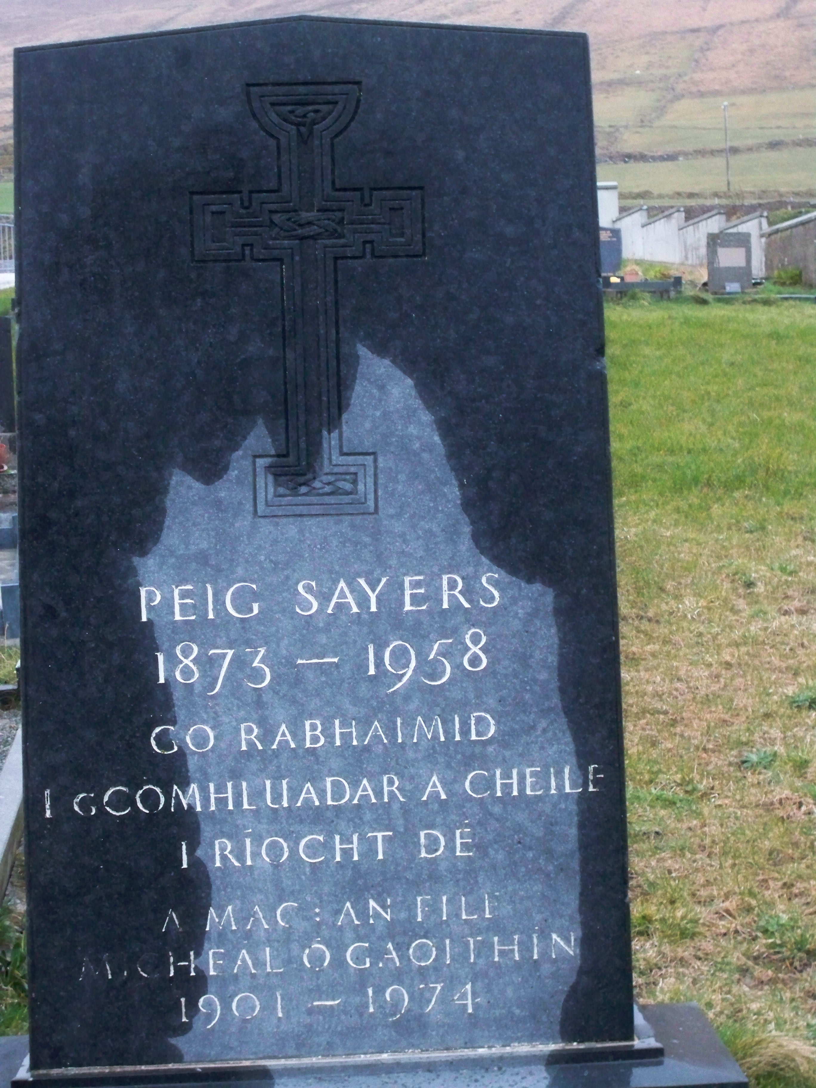
Máiréad "Peig" Sayers (; 29 March 18738 December 1958) was an Irish author and seanchaí ( or – plural: ) born in Dún Chaoin, County Kerry, Ireland. Seán Ó Súilleabháin, the former Chief archivist for the Irish Folklore Commission, described her as "one of the greatest woman storytellers of recent times".Sean O'Sullivan, "Folktales of Ireland," pages 270–271: "The narrator, Peig Sayers, who died on 8 December 1958, was one of the greatest storytellers of recent times. Some of her tales were recorded on the Ediphone in the late 'twenties by Dr. Robin Flower, Keeper of Manuscripts at the British Museum, and again by Seosamh Ó Dálaigh twenty years later." Biography She was born Máiréad Sayers in the townland of Vicarstown, Dunquin, County Kerry, the youngest child of the family. She was called Peig after her mother, Margaret "Peig" Brosnan, from Castleisland. Her father Tomás Sayers was a renowned storyteller who passed on many of his tales to Peig. At the age of 12 ... [...More Info...] [...Related Items...] OR: [Wikipedia] [Google] [Baidu] |
Pádraig Ó Siochfhradha
Pádraig Ó Siochfhradha (; 10 March 1883 – 19 November 1964) and his brother Mícheál Ó Siochfhradha were Irish language writers, teachers and storytellers, from County Kerry, Ireland. Pádraig Ó Siochfhradha wrote under the Gaelic pen-name (; "The Hawk"; contemporary spelling ''An Seaḃac''). His most famous book is the semi-autobiographical comedy ''Jimín Mháire Thaidhg'', published in 1919, which follows his childhood under the control of his powerful mother, Máire. He became an active organiser for the Irish Volunteers in 1913 and was imprisoned three times for his activities. He was an independent member of Seanad Éireann Seanad Éireann (, ; " Senate of Ireland") is the upper house of the Oireachtas (the Irish legislature), which also comprises the President of Ireland and Dáil Éireann (the lower house). It is commonly called the Seanad or Senate and its ... from 1946–48, 1951–54 and 1957–64, being nominated by the Taoiseach on each occasion. He ... [...More Info...] [...Related Items...] OR: [Wikipedia] [Google] [Baidu] |
Irish Language
Irish (an Caighdeán Oifigiúil, Standard Irish: ), also known as Gaelic, is a Goidelic languages, Goidelic language of the Insular Celtic branch of the Celtic language family, which is a part of the Indo-European languages, Indo-European language family. Irish is indigenous language, indigenous to the Ireland, island of Ireland and was the population's first language until the 19th century, when English (language), English gradually became Linguistic imperialism, dominant, particularly in the last decades of the century. Irish is still spoken as a first language in a small number of areas of certain counties such as County Cork, Cork, County Donegal, Donegal, County Galway, Galway, and County Kerry, Kerry, as well as smaller areas of counties County Mayo, Mayo, County Meath, Meath, and County Waterford, Waterford. It is also spoken by a larger group of habitual but non-traditional speakers, mostly in urban areas where the majority are second language, second-language speakers. ... [...More Info...] [...Related Items...] OR: [Wikipedia] [Google] [Baidu] |
Gaeltacht
( , , ) are the districts of Ireland, individually or collectively, where the Irish government recognises that the Irish language is the predominant vernacular, or language of the home. The ''Gaeltacht'' districts were first officially recognised during the 1920s in the early years of the Irish Free State, following the Gaelic Revival, as part of a government policy aimed at restoring the Irish language. The Gaeltacht is threatened by serious language decline. Research published in 2015 showed that Irish is spoken on a daily basis by two-thirds or more of the population in only 21 of the 155 electoral divisions in the Gaeltacht. Daily language use by two-thirds or more of the population is regarded by some academics as a tipping point for language survival.RTÉ News Report of Friday 29 May 2015 History In 1926, the official Gaeltacht was designated as a result of the report of the first Gaeltacht Commission '' Coimisiún na Gaeltachta''. The exact boundaries were not de ... [...More Info...] [...Related Items...] OR: [Wikipedia] [Google] [Baidu] |
Blasket Islands
The Blasket Islands ( ga, Na Blascaodaí) are an uninhabited group of islands off the west coast of the Dingle Peninsula in County Kerry, Ireland. The last island to hold a significant population, Great Blasket Island, was abandoned in 1954 due to population decline and is best known for a number of gifted Irish language writers who vividly described their way of life and who kept alive old Irish folk tales of the land. History The islands were inhabited until 1954 by a completely Irish-speaking population and today are part of the Gaeltacht. At its peak, the islands had 175 residents. The population declined to 22 by 1953. The government evacuated most of the remaining residents to the mainland on 17 November 1953 because of increasingly extreme winter weather that left the island's ageing population cut off from emergency services.Stagles, Joan and Ray, ''The Blasket Islands: Next Parish America''. Dublin: O'Brien Press, 1980 (new edn. 1998). The evacuation was seen as nece ... [...More Info...] [...Related Items...] OR: [Wikipedia] [Google] [Baidu] |
Cirque
A (; from the Latin word ') is an amphitheatre-like valley formed by glacial erosion. Alternative names for this landform are corrie (from Scottish Gaelic , meaning a pot or cauldron) and (; ). A cirque may also be a similarly shaped landform arising from fluvial erosion. The concave shape of a glacial cirque is open on the downhill side, while the cupped section is generally steep. Cliff-like slopes, down which ice and glaciated debris combine and converge, form the three or more higher sides. The floor of the cirque ends up bowl-shaped, as it is the complex convergence zone of combining ice flows from multiple directions and their accompanying rock burdens. Hence, it experiences somewhat greater erosion forces and is most often overdeepened below the level of the cirque's low-side outlet (stage) and its down-slope (backstage) valley. If the cirque is subject to seasonal melting, the floor of the cirque most often forms a tarn (small lake) behind a dam, which marks the ... [...More Info...] [...Related Items...] OR: [Wikipedia] [Google] [Baidu] |
Castlegregory
Castlegregory (, meaning "Griaire's Castle") is a village in County Kerry, Ireland. It is situated on the north side of the Dingle Peninsula, halfway between Tralee and Dingle. As of the 2016 Census, Castlegregory had a population of 250. Castlegregory was named after a castle built by Gregory Hoare in the 16th century. It is the principal village in Lettragh, the name given to the northern side of the Dingle Peninsula. Geography The village is located at the foot of a sandy peninsula called the Maharees separating Brandon Bay to the west from Tralee Bay on the east. Off the peninsula are a number of small islands, called the Seven Hoggs, or the Maharee Islands. A small fishing harbour is located at Fahamore on Scraggane Bay, about 5 km outside the village at the tip of the Maharees peninsula. The village is surrounded by the mountains of the Dingle peninsula and overlooked directly by Beenoskee and Stradbally Mountains. To the west is Mount Brandon. Castlegregory is a ... [...More Info...] [...Related Items...] OR: [Wikipedia] [Google] [Baidu] |
Brandon Bay
Cé Bhréannain or Bréanainn (anglicized as Brandon) is a Gaeltacht village on the northern coast of the Dingle Peninsula in County Kerry, Ireland. It lies directly north of Dingle, at the foot of Mount Brandon and on the shores of Brandon Bay. The ancient Celtic harvest festival, a pre-Christian celebration called '' Féile Lughnasa'', takes place yearly in the village and surrounding area on the last Sunday of July. Windsurfing Brandon Carter Bay is one of the top windsurfing locations in Ireland. Host of three PWA professional wave sailing events in 2000, 2001 and 2002, it is home to several windsurfing schools catering to all levels from beginner to advanced. The Maharees, a sandy peninsula between Brandon Bay and Tralee Bay, is where most windsurfing activity is based. Great locations include Sandy Bay for beginners, Scraggane Bay for intermediates on flat water and Brandon Bay itself for advanced wave sailing. Surfing is also growing quickly in the Maharees, with ... [...More Info...] [...Related Items...] OR: [Wikipedia] [Google] [Baidu] |
Conor Pass
Conor Pass or Connor Pass () is one of the highest Irish mountain passes served by an asphalted road. It is located on the R560 road in County Kerry, Ireland. Geography The high pass connects Dingle, on the south-western end of the Dingle Peninsula, with Brandon Bay and Castlegregory in the north-east. Access to the pass A twisty one-lane asphalted road leads to the pass. The drive is considered one of the most beautiful in Ireland. The scenic road leading to the pass weaves its way around the sharp cliff faces and past high corrie lakes. Vehicles over two tonnes in weight are prohibited from using the road in order to avoid difficulties in passing. Bicycle ascent to the pass is one of the most famous and difficult climbs in Ireland. See also * List of mountain passes This is a list of mountain passes. Africa Egypt * Halfaya Pass (near Libya) Lesotho * Moteng Pass * Mahlasela pass * Sani Pass Morocco * Tizi n'Tichka South Africa * Eastern Cape Passes * We ... [...More Info...] [...Related Items...] OR: [Wikipedia] [Google] [Baidu] |


