|
Dindo, Bosnia And Herzegovina
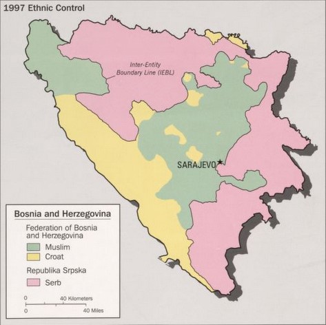
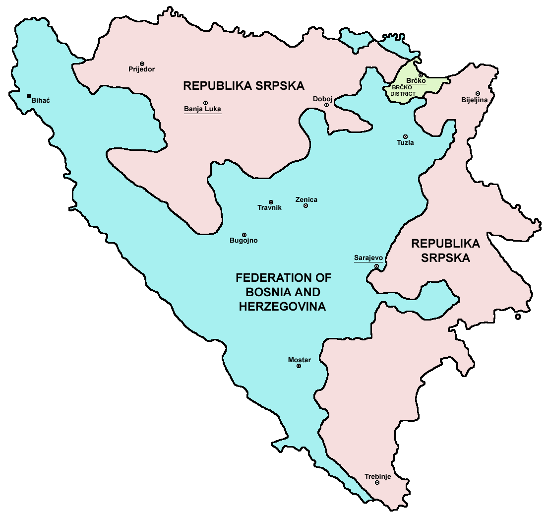
Dindo is a village in the municipality of Konjic, in the Federation of Bosnia and Herzegovina entity of Bosnia and Herzegovina. Dindo is located in a mountainous rural area in the south-eastern part of Konjic Municipality on the border with Kalinovik Municipality, which also marks the Inter-Entity Boundary Line (IEBL) between the two constituent entities of Bosnia and Herzegovina, FB&H and RS. A bridge carrying an important road across the Ljuta, a right tributary of the Neretva, was destroyed in 1995 during the last days of the Bosnian War before the signing of the Dayton Agreement. The destroyed bridge was replaced with a Bailey bridge in 2002. The work was undertaken by a Spanish Engineering Unit of SFOR based in Mostar Mostar (, ; sr-Cyrl, Мостар, ) is a city and the administrative center of Herzegovina-Neretva Canton of the Federation of Bosnia and Herzegovina, an entity of Bosnia and Herzegovina, and the historical capital of Herzegovina. Mostar is sit .... As ... [...More Info...] [...Related Items...] OR: [Wikipedia] [Google] [Baidu] |
Entities Of Bosnia And Herzegovina
Countries' first-level (top-level) administrative division Administrative division, administrative unit,Article 3(1). country subdivision, administrative region, subnational entity, constituent state, as well as many similar terms, are generic names for geographical areas into which a particular, ind ...s. ''Please note:'' This category's subcategories contain articles on each subdivision of the country while each directly included article considers the subdivisions structure of the country. ''Further note:'' This category's subcategories are indexed according to country, but its directly included articles are not: they are indexed by type of subdivision (provinces, counties, etc). Articles with non-English subdivision terms in their titles either have their redirects indexed instead, or are indexed by the common English translation for said subdivision. This facilitates comparisons between similarly named subdivisions. {{CatAutoTOC 1st-level ... [...More Info...] [...Related Items...] OR: [Wikipedia] [Google] [Baidu] |
Ljuta (Dindolka)
Ljuta, also called Dindolka, is one of the main tributaries of the first section of the Neretva river, also called Upper Neretva ''( bs, Gornja Neretva)''. It meets Neretva from the right, flowing from north to south, between Treskavica and Visočica mountains. Geography The Ljuta river begins as Srednja Voda creek ''()'' from "Baletina Voda" spring ''()'' that emerges in the areal above Ljuta village, under the northwestern ridge of Treskavica mountain, and after a short run, cca. 5 kilometers, it joins with the Bijela Vodica and Božija Vodica creeks where it become the Ljuta. The Ljuta river forms a cca 30km long valley squeezed between Treskavica and Visočica, southeast from Sarajevo. Protection Bosnia and Herzegovina on several occasions, since 1998, was preparing to establish a large national park which, according to developed but never operationalized plans, would comprise the entire region of Gornja Neretva ''( en, Upper Neretva)'', including region between the Ra ... [...More Info...] [...Related Items...] OR: [Wikipedia] [Google] [Baidu] |
Villages In The Federation Of Bosnia And Herzegovina
A village is a clustered human settlement or community, larger than a hamlet but smaller than a town (although the word is often used to describe both hamlets and smaller towns), with a population typically ranging from a few hundred to a few thousand. Though villages are often located in rural areas, the term urban village is also applied to certain urban neighborhoods. Villages are normally permanent, with fixed dwellings; however, transient villages can occur. Further, the dwellings of a village are fairly close to one another, not scattered broadly over the landscape, as a dispersed settlement. In the past, villages were a usual form of community for societies that practice subsistence agriculture, and also for some non-agricultural societies. In Great Britain, a hamlet earned the right to be called a village when it built a church. [...More Info...] [...Related Items...] OR: [Wikipedia] [Google] [Baidu] |
Mostar
Mostar (, ; sr-Cyrl, Мостар, ) is a city and the administrative center of Herzegovina-Neretva Canton of the Federation of Bosnia and Herzegovina, an entity of Bosnia and Herzegovina, and the historical capital of Herzegovina. Mostar is situated on the Neretva River and is the fifth-largest city in the country. Mostar was named after the bridge keepers (''mostari'') who in the medieval times guarded the Stari Most (Old Bridge) over the Neretva. The Old Bridge, a UNESCO World Heritage Site, built by the Ottoman Bosnia and Herzegovina, Ottomans in the 16th century, is one of Bosnia and Herzegovina's most visited landmarks, and is considered an exemplary piece of Islamic architecture in the Balkans. History Ancient and medieval history Human settlements on the river Neretva, between Mount Hum (Mostar), Mount Hum and the Velež Mountain, have existed since prehistory, as witnessed by discoveries of fortified enceintes and cemeteries. Evidence of Roman people, Roman occupation wa ... [...More Info...] [...Related Items...] OR: [Wikipedia] [Google] [Baidu] |
SFOR
The Stabilisation Force in Bosnia and Herzegovina (SFOR) was a NATO-led multinational peacekeeping force deployed to Bosnia and Herzegovina after the Bosnian war. Although SFOR was led by NATO, several non-NATO countries contributed troops. It was replaced by EUFOR Althea in December 2004. Mission The stated mission of SFOR was to "deter hostilities and stabilise the peace, contribute to a secure environment by providing a continued military presence in the Area Of Responsibility (AOR), target and co-ordinate SFOR support to key areas including primary civil implementation organisations, and progress towards a lasting consolidation of peace, without further need for NATO-led forces in Bosnia and Herzegovina". Structure and history SFOR was established in Security Council Resolution 1088 on 12 December 1996. It succeeded the much larger Implementation Force IFOR which was deployed to Bosnia and Herzegovina on 20 December 1995 with a one-year mandate. The commanders of the SFOR ... [...More Info...] [...Related Items...] OR: [Wikipedia] [Google] [Baidu] |
Bailey Bridge
A Bailey bridge is a type of portable, pre-fabricated, truss bridge. It was developed in 1940–1941 by the British for military use during the Second World War and saw extensive use by British, Canadian and American military engineering units. A Bailey bridge has the advantages of requiring no special tools or heavy equipment to assemble. The wood and steel bridge elements were small and light enough to be carried in trucks and lifted into place by hand, without the use of a crane. The bridges were strong enough to carry tanks. Bailey bridges continue to be used extensively in civil engineering construction projects and to provide temporary crossings for pedestrian and vehicle traffic. A Bailey bridge and its construction were prominently featured in the 1977 film '' A Bridge Too Far''. Design The success of the Bailey bridge was due to the simplicity of the fabrication and assembly of its modular components, combined with the ability to erect and deploy sections with a mini ... [...More Info...] [...Related Items...] OR: [Wikipedia] [Google] [Baidu] |
Dayton Agreement
The General Framework Agreement for Peace in Bosnia and Herzegovina, also known as the Dayton Agreement or the Dayton Accords (Croatian: ''Daytonski sporazum'', Serbian and Bosnian: ''Dejtonski mirovni sporazum'' / Дејтонски мировни споразум), is the peace agreement reached at Wright-Patterson Air Force Base near Dayton, Ohio, United States, on 21 November 1995, and formally signed in Paris, on 14 December 1995. These accords put an end to the three-and-a-half-year-long Bosnian War, which was part of the much larger Yugoslav Wars. The warring parties agreed to peace and to a single sovereign state known as Bosnia and Herzegovina composed of two parts, the largely Serb-populated Republika Srpska and mainly Croat-Bosniak-populated Federation of Bosnia and Herzegovina. The agreement has been criticized for creating ineffective and unwieldy political structures and entrenching the ethnic cleansing of the previous war. Negotiation and signature T ... [...More Info...] [...Related Items...] OR: [Wikipedia] [Google] [Baidu] |
Bosnian War
The Bosnian War ( sh, Rat u Bosni i Hercegovini / Рат у Босни и Херцеговини) was an international armed conflict that took place in Bosnia and Herzegovina between 1992 and 1995. The war is commonly seen as having started on 6 April 1992, following a number of earlier violent incidents. The war ended on 14 December 1995 when the Dayton accords were signed. The main belligerents were the forces of the Republic of Bosnia and Herzegovina and those of Herzeg-Bosnia and Republika Srpska, proto-states led and supplied by Croatia and Serbia, respectively. The war was part of the breakup of Yugoslavia. Following the Slovenian and Croatian secessions from the Socialist Federal Republic of Yugoslavia in 1991, the multi-ethnic Socialist Republic of Bosnia and Herzegovina – which was inhabited by mainly Muslim Bosniaks (44%), Orthodox Serbs (32.5%) and Catholic Croats (17%) – passed a referendum for independence on 29 February 1992. Political representatives ... [...More Info...] [...Related Items...] OR: [Wikipedia] [Google] [Baidu] |
Neretva
The Neretva ( sr-cyrl, Неретва, ), also known as Narenta, is one of the largest rivers of the eastern part of the Adriatic basin. Four HE power-plants with large dams (higher than 150,5 metres) provide flood protection, power and water storage. It is recognized for its natural environment and diversity of its landscape. Freshwater ecosystems have suffered from an increasing population and the associated development pressures. One of the most valuable natural resources of Bosnia and Herzegovina and Croatia is its freshwater resource, contained by an abundant wellspring and clear rivers. Situated between the major regional rivers (Drina river on the east, Una river on the west and the Sava river) the Neretva basin contains the most significant source of drinking water. The Neretva is notable among rivers of the Dinaric Alps region, especially regarding its diverse ecosystems and habitats, flora and fauna, cultural and historic heritage. Its name has been suggested to c ... [...More Info...] [...Related Items...] OR: [Wikipedia] [Google] [Baidu] |
Republika Srpska
Republika Srpska ( sr-Cyrl, Република Српска, lit=Serb Republic, also known as Republic of Srpska, ) is one of the two Political divisions of Bosnia and Herzegovina, entities of Bosnia and Herzegovina, the other being the Federation of Bosnia and Herzegovina. It is located in the north and east of the country. Its largest city and administrative centre is Banja Luka, lying on the Vrbas (river), Vrbas river. Republika Srpska was formed in 1992 at the outset of the Bosnian War with the stated intent to safeguard the interests of the Serbs of Bosnia and Herzegovina. The war saw the Ethnic cleansing in the Bosnian War, expulsion of the vast majority of Croats of Bosnia and Herzegovina, Croats and Bosniaks from the territory claimed by Republika Srpska and an inflow of Serbs expelled from Federation of Bosnia and Herzegovina. Following the Dayton Agreement of 1995, Republika Srpska achieved international recognition as an entity within Bosnia and Herzegovina. ... [...More Info...] [...Related Items...] OR: [Wikipedia] [Google] [Baidu] |
Federation Of Bosnia And Herzegovina
The Federation of Bosnia and Herzegovina is one of the two entities within the State of Bosnia and Herzegovina, the other being Republika Srpska. The Federation of Bosnia and Herzegovina consists of 10 autonomous cantons with their own governments and legislatures. The Federation was created by the 1994 Washington Agreement, which ended the Croat–Bosniak War within the Bosnian War, and established a constituent assembly that continued its work until October 1996. The Federation has a capital, government, president, parliament, customs and police departments and two postal systems. It occupies about half of the land of Bosnia and Herzegovina. From 1996 until 2005 it had its own army, the Army of the Federation of Bosnia and Herzegovina, later merged in the Armed Forces of Bosnia and Herzegovina. The capital and largest city is Sarajevo with 275,524 inhabitants. History The basis for the creation of the Federation of Bosnia and Herzegovina were laid down by the W ... [...More Info...] [...Related Items...] OR: [Wikipedia] [Google] [Baidu] |
Inter-Entity Boundary Line
The Inter-Entity Boundary Line ( sh, Međuentitetska linija), commonly abbreviated IEBL, is the administrative line that subdivides Bosnia and Herzegovina into two entities, ''Republika Srpska'' and the Federation of Bosnia and Herzegovina. The total length of the Inter-Entity Boundary Line is . History The present political divisions of Bosnia and Herzegovina is based on ''Annex 4'' of the ''General Framework Agreement for Peace'', also known as Dayton Agreement, concluded at the Dayton Peace Conference in November 1995, and subsequently signed in Paris on December 14, 1995. A key component of this was the delineation of the Inter-Entity Boundary Line (IEBL), to which many of the tasks listed in the other Annexes referred. In particular the IEBL affected the tasks of the ''Military Annexes'', such as the initial and immediate ''"Separation of Forces"'', the creation of an initial ''"Zone of Separation"'', the ''"Transfer of Areas"'' between the entities and the district, an ... [...More Info...] [...Related Items...] OR: [Wikipedia] [Google] [Baidu] |


