|
Dietingen
Dietingen is a municipality in the district of Rottweil, in Baden-Württemberg, Germany. Geography Dietingen is located in the Upper Neckar valley between the Black Forest and the Swabian Jura in 544–623 meters altitude, about five kilometers away from the town of Rottweil. Neighboring communities The municipality borders to Epfendorf, on the east to Rosenfeld and Zimmern unter der Burg in the Zollernalbkreis, in the south to the county town Rottweil and in the west to Villingendorf. Municipality arrangement The municipality Dietingen includes the formerly independent municipalities Böhringen, Gößlingen, Irslingen and Rotenzimmern. *To Böhringen belonged the village Böhringen and residential spaces Böhringer mill and chapel courtyard. *To Dietingen belonged before the local government reform in the 1970s the village Dietingen, the castle and farmstead Hohenstein, the farm Tierstein and the living space Hasler-Wasen. *To Gößlingen belonged the village Gößlingen. *To ... [...More Info...] [...Related Items...] OR: [Wikipedia] [Google] [Baidu] |
Rottweil (district)
Rottweil is a Districts of Germany, ''Landkreis'' (district) in the middle of Baden-Württemberg, Germany. It is part of the Schwarzwald-Baar-Heuberg region in the Breisgau-Hochschwarzwald regional district. Neighboring districts are (from north clockwise) Freudenstadt (district), Freudenstadt, Zollernalbkreis, Tuttlingen (district), Tuttlingen, Schwarzwald-Baar and Ortenaukreis. History The district dates back to the ''Oberamt Rottweil'', which was created in 1806/08 when the previously free imperial city Rottweil became part of Württemberg. In 1934 it was renamed to ''Landkreis'' (district). 1938 the two neighboring districts Sulz and Oberndorf were dissolved, and most of the district Oberndorf and a small part of Sulz was added to the district Rottweil. During World War II, a series of Nazi concentration camps, collectively known as KZ Schörzingen-Rottweil-Zepfenhan, were located in the area. In 1973 in another communal reform several municipalities from the districts Horb ... [...More Info...] [...Related Items...] OR: [Wikipedia] [Google] [Baidu] |
Epfendorf
Epfendorf is a municipality in the district of Rottweil, in Baden-Württemberg, Germany. Epfendorf is located in the Upper Neckar valley between Oberndorf am Neckar and Rottweil. Neighboring communities The municipality borders to the north to the town of Oberndorf, to the east to the city of Rosenfeld in Zollernalbkreis, on the south to Dietingen and Villingendorf and on the west to Bösingen. Outline The community consists of the main town Epfendorf and the three districts Harthausen, Talhausen and Trichtingen. History The exact age of Epfendorf is not known, but the place was first documented in 994. Findings indicate a Roman settlement, a Roman road led to the Roman settlement in Waldmössingen. On January 1, 1974, the municipality Harthausen was incorporated to Epfendorf. The incorporation of Trichtingen was on January 1, 1975. Religions Mariä Heimsuchung ( Visitation of Mary) is a Roman Catholic parish of the Roman Catholic Diocese of Rottenburg-Stuttgart in Talhause ... [...More Info...] [...Related Items...] OR: [Wikipedia] [Google] [Baidu] |
Tieringen
Tieringen is a district of the town of Meßstetten in the Zollernalbkreis district of Baden-Württemberg, Germany. As of 2010 Tieringen had a population of 1069. Tieringen is a capital of textile production. Urtica dioica L. convar. fibra is growing on farms. Sport * trail mountain bike Tieringen Albtrauf to Balingen Balingen (; Swabian: ''Balenga'') is a town in Baden-Württemberg, Germany, capital of the district of Zollernalbkreis. It is located near the Swabian Jura, approx. 35 km to the south of Tübingen, 35 km northeast of Villingen-Schwenn ...-Weilstetten Lochenpass 4,7 km car road, bike trail 1,9 km downhill. References Towns in Baden-Württemberg Zollernalbkreis {{Zollernalbkreis-geo-stub ... [...More Info...] [...Related Items...] OR: [Wikipedia] [Google] [Baidu] |
Upper Danube Nature Park
The Upper Danube Nature Park (German: ''Naturpark Obere Donau''), founded in 1980, is located in the south of Baden-Württemberg in Germany and encloses primarily the districts of Tuttlingen and Sigmaringen. It encompassed initially 860 km2 that were increased by about 500 km2 in 2005. The headquarters of the nature reserve association is at Beuron. The highest proportion of the nature park is taken up by the Heuberg, the south-western plateau of the Swabian Alb, and is punctuated by the Danube. Geography Two small rivers, the Brigach and the Breg at the eastern border of the Black Forest unite at Donaueschingen to form the Danube. The Danube passes through the Upper Danube Nature Park between Immendingen and Ertingen, its deep bed dug deep into the Jurassic stone of the Swabian Alb. In this break-through valley of the still narrow river mighty rocks like chalk rocks ("Kalkfelsen") are exposed: One of it is the " Knopfmacherfelsen" at Beuron. Beuron with its Beuron ... [...More Info...] [...Related Items...] OR: [Wikipedia] [Google] [Baidu] |
Kleinengstingen
Engstingen is a municipality in the Tübingen administrative region (''Regierungsbezirk'') in Baden-Württemberg, Germany. It lies in the Swabian Jura (plateau), about south of Reutlingen. It was formed on January 1, 1975 from the former independent municipalities of ''Großengstingen'', ''Kleinengstingen'' and ''Kohlstetten''. Engstingen is located on the northern edge of the Swabian Jura, at altitude on the Alb plateau near the Alb edge in the valley of Ur-Lauter, about 15 km south of the town Reutlingen. Municipality According to the municipal reform on January 1, 1975, the three previously independent municipalities Großengstingen, Kleinengstingen and Kohlstetten and the industrial park ''Gewerbepark Haid'' were combined into Engstingen. The village of Großengstingen and the houses at Großengstingen railway station and Haid belonged previously to the former municipality Großengstingen. The former municipalities Kleinengstingen and Kohlstetten each included only th ... [...More Info...] [...Related Items...] OR: [Wikipedia] [Google] [Baidu] |
Hohenzollerische Landesbahn
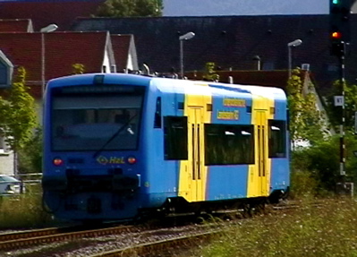
The Hohenzollerische Landesbahn (HzL) is the largest non-federally owned railway company in the German state of Baden-Württemberg after the Albtal-Verkehrs-Gesellschaft and Südwestdeutsche Verkehrs-Aktiengesellschaft. It has operates passenger and freight traffic since 1900. Its field of activity now extends to large parts of southern Baden-Württemberg. The focus of its business in 2011, with revenue of €32.4 million (80%), is railway passenger operations, 11% (€4.3 million) of revenues come from road transport bus operations and revenue of €3.6 million (9%) is produced by rail freight operations. The HzL is a member of the ''Tarifverband der Bundeseigenen und Nichtbundeseigenen Eisenbahnen in Deutschland'' ("fare association of federally-owned and non-federally owned railways in Germany", TBNE) and the ''Verband Deutscher Verkehrsunternehmen'' ("association of German transport companies"). On 1 January 2018, the HzL merged with the Südwestdeutsche Verkehrs-Aktienge ... [...More Info...] [...Related Items...] OR: [Wikipedia] [Google] [Baidu] |
Schömberg, Zollernalbkreis
Schömberg is a town in the Zollernalbkreis district of Baden-Württemberg, Germany. History Until 1805, the towns of Schömberg and were possessions of the County of Hohenberg. As part of the process of German mediatization, the two towns were awarded to the Kingdom of Württemberg, whose government assigned them in 1810 to . The towns were reassigned to in 1938. In the 1950s and 1960s, Schömberg enjoyed a period of growth to the south, east, and west. The merged the district of Balingen into the newly created Zollernalb district in January. The next month, on 1 February, Schömberg and Schörzingen merged into a single municipality. There was further urban growth in the 1980s, when a gap between some industrial parks to the south was closed with the construction of additional commercial zones. Geography The township ('' Stadt'') of Schömberg is located in Zollernalbkreis, a district of the German state of Baden-Württemberg. It is physically located in the foothills of t ... [...More Info...] [...Related Items...] OR: [Wikipedia] [Google] [Baidu] |
Burgstall
A ''burgstall'' is a German term referring to a castle of which so little is left that its appearance cannot effectively be reconstructed.''Burgstall'' in the ''Adelung'' at lexika.digitale-sammlungen.de It has no direct equivalent in English, but may be loosely translated as "castle site". Variations in the literature include ''Burgstelle'', ''Altburgstelle'', ''die Burgställe'' (plural), ''Burgstähl'' (archaic) or ''abgegangene Burg'' ("lost castle"). In German castle studies, a ''burgstall'' is a castle that has effectively been levelled, whereas a "ruin" (''Ruine'') still has recognisable remnants of the original castle above the level of the ground. Definitions The word ''burgstall'' is of medieval origin and comes from ''Burg'' = "castle" and ''Stelle'' = "plac ...[...More Info...] [...Related Items...] OR: [Wikipedia] [Google] [Baidu] |
Villingendorf
Villingendorf is a town in the Rottweil (district), district of Rottweil, in Baden-Württemberg, Germany. References Rottweil (district) Populated places on the Neckar basin Populated riverside places in Germany {{Rottweil-geo-stub ... [...More Info...] [...Related Items...] OR: [Wikipedia] [Google] [Baidu] |
Baden-Württemberg
Baden-Württemberg (; ), commonly shortened to BW or BaWü, is a German state () in Southwest Germany, east of the Rhine, which forms the southern part of Germany's western border with France. With more than 11.07 million inhabitants across a total area of nearly , it is the third-largest German state by both area (behind Bavaria and Lower Saxony) and population (behind North Rhine-Westphalia and Bavaria). As a federated state, Baden-Württemberg is a partly-sovereign parliamentary republic. The largest city in Baden-Württemberg is the state capital of Stuttgart, followed by Mannheim and Karlsruhe. Other major cities are Freiburg im Breisgau, Heidelberg, Heilbronn, Pforzheim, Reutlingen, Tübingen, and Ulm. What is now Baden-Württemberg was formerly the historical territories of Baden, Prussian Hohenzollern, and Württemberg. Baden-Württemberg became a state of West Germany in April 1952 by the merger of Württemberg-Baden, South Baden, and Württemberg-Hohenzollern. The ... [...More Info...] [...Related Items...] OR: [Wikipedia] [Google] [Baidu] |
Zollernalbkreis
The Zollernalbkreis is a Districts of Germany, ''Landkreis'' (district) in the middle of Baden-Württemberg, Germany. The district is located in the Swabian Alb, and contains the second highest elevation of this range, the high ''Oberhohenberg''. In the south-east the district nearly reaches to the river Danube. The district was created on January 1, 1973, when the two previous districts Balingen and Hechingen were merged. Neighboring districts are (from north clockwise) Tübingen (district), Tübingen, Reutlingen (district), Reutlingen, Sigmaringen (district), Sigmaringen, Tuttlingen (district), Tuttlingen, Rottweil (district), Rottweil and Freudenstadt (district), Freudenstadt. Coat of arms The coat of arms show the black-and-white checkered symbol of the Hohenzollern in the left half, and the triple black deer antler on yellow ground as the symbol of Württemberg. Almost all of the district's area belonged to these two states historically. Towns (''Städte'') and municip ... [...More Info...] [...Related Items...] OR: [Wikipedia] [Google] [Baidu] |


.jpg)


