|
Dhanushkodi
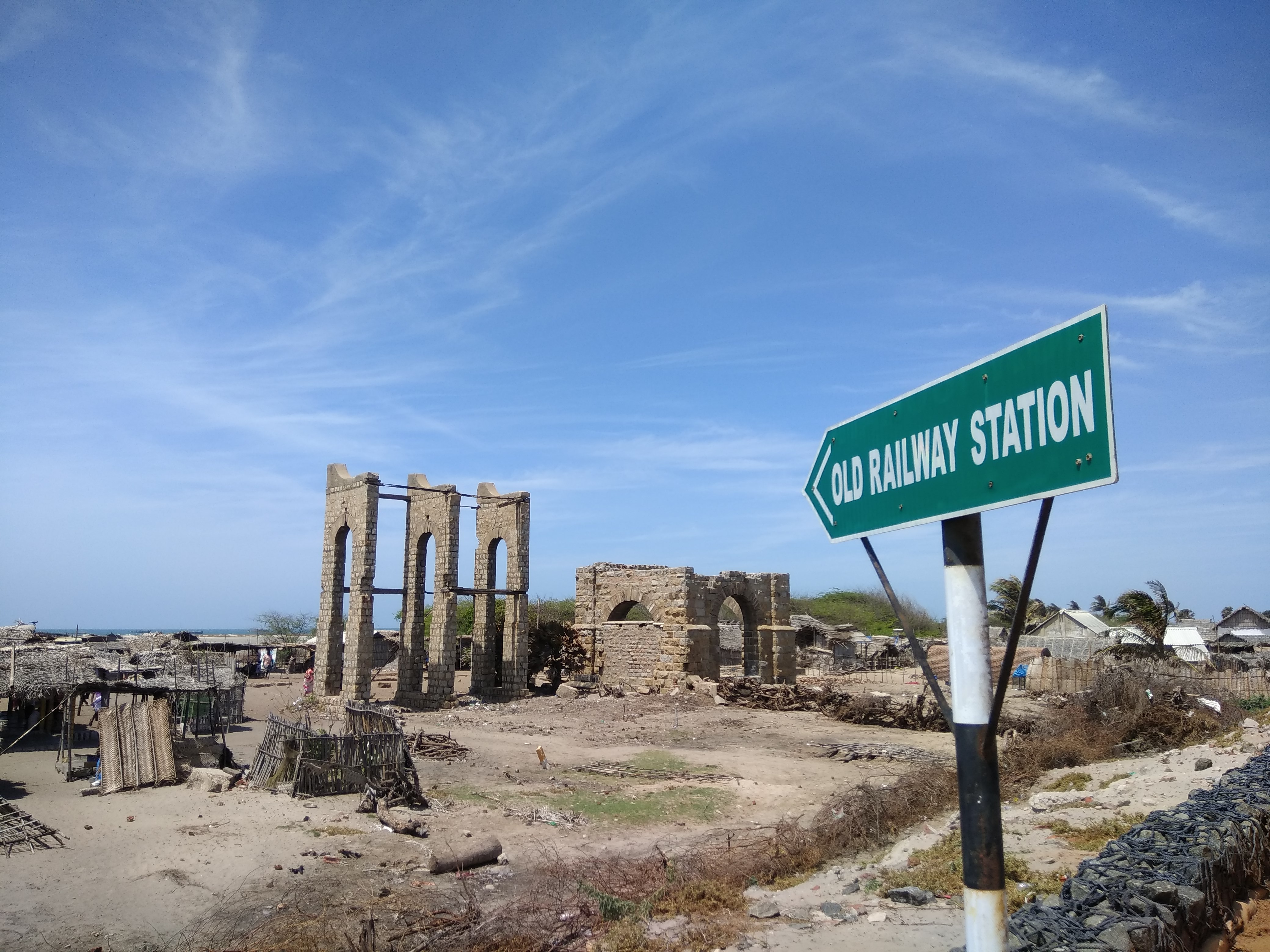
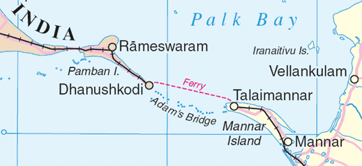
Dhanushkodi is an abandoned town at the south-eastern tip of Pamban Island of the state of Tamil Nadu in India. It is south-east of Pamban and is about west of Talaimannar in Sri Lanka. The town was destroyed during the 1964 Rameswaram cyclone and remains uninhabited in the aftermath. Today only a few vendors and restaurants can be seen at Dhanushkodi during the day along with the ruins of the long destroyed town. Geography Dhanushkodi is on the tip of Pamban island, separated from the mainland by the Palk Strait. Transport The National Highway completed the 9.5-km-long road – 5 km from Mukuntharayar Chathiram to Dhanushkodi and 4.5 km from Dhanushkodi to Arichamunai. Until 2016, Dhanushkodi was reachable either on foot along the seashore or in jeeps. In 2016, a road was completed from the village of Mukundarayar Chathiram. A metre gauge railway line connected Mandapam on mainland India to Dhanushkodi. Boat mail express ran from Chennai Egmore to Dhanushkodi till ... [...More Info...] [...Related Items...] OR: [Wikipedia] [Google] [Baidu] |
1964 Rameswaram Cyclone
The 1964 Rameswaram cyclone (also known as the Dhanushkodi cyclone) was regarded as one of the most powerful storms to ever strike India on record. The system was first identified as an area of low pressure over the Andaman Sea on December 15. Following interaction with a tropical wave, it began to develop and became a depression by December 18. Increasingly rapid intensification ensued over the following days with the cyclone attaining hurricane-force winds around 5°N the next day. Early on December 23, the storm struck Ceylon near Trincomalee with winds estimated at , ranking it as a modern-day super cyclonic storm. Weakening somewhat, the storm soon struck Tamil Nadu. Rapid weakening followed once the cyclone was onshore and it degenerated into a depression on December 24 as it emerged over the Arabian Sea. The system later dissipated on December 26 over open water. Meteorological history On December 15, 1964, an area of low pressure was identifie ... [...More Info...] [...Related Items...] OR: [Wikipedia] [Google] [Baidu] |
Boat Mail
The Rameswaram (Boat Mail) Express, previously known as Boat Mail or Indo-Ceylon Express, is an express train that connects Rameswaram with the state capital Chennai via Devakottai. During 1900's it was a combined train and steamer ferry service between India and Ceylon (now Sri Lanka). Connecting Chennai and Colombo, the system initially utilised a rail-to-sea operation, but changed to a rail-to-sea-to-rail operation.http://www.irfca.org/faq/faq-seltrain.html Famous Trains Passengers could buy a single ticket for the journey. Now at present, it runs from Chennai Egmore to Rameswaram via Villuppuram, Kumbakonam, Trichy, Pudukkottai, Karaikkudi, Devakottai, Manamadurai, Paramakkudi, Ramanathapuram, Mandapam and Pamban. History The train's name commemorates the 19th century mail service between Tamil Nadu and Sri Lanka (then Ceylon). It is one of the top most prestigious trains of Indian Railways and it has completed 100 years of service in 2014. Before cyclone, the t ... [...More Info...] [...Related Items...] OR: [Wikipedia] [Google] [Baidu] |
Palk Strait
The Palk Strait ( ta, பாக்கு நீரிணை ''Pākku Nīriṇai'', si, පෝක් සමුද්ර සන්ධිය ''Pok Samudra Sandhiya'') is a strait between the Tamil Nadu state of India and the Jaffna District of the Northern Province of the island nation of Sri Lanka. It connects the Bay of Bengal in the northeast with Palk Bay in the southwest. With a minimum depth of less than 9.1 m,Palk Bay Sea Seek. it is 40 to 85 miles (64 to 137 km) wide and 85 miles long.Palk Strait Encyclopedia britannica. Several rivers flow into it, including the Vaigai River of Tamil Na ... [...More Info...] [...Related Items...] OR: [Wikipedia] [Google] [Baidu] |
Dhanushkodi Tirtham
Dhanushkodi Tirtham is one of the Tirthas in the island of Rameswaram, Tamil Nadu, India. This is located beside the ghost town of Dhanushkodi at the easternmost tip of Rameswaram Island. Rama used his bow's (Dhanush) end (Kodi) to break the bridge - Rama Setu Adam's Bridge, '; ta, ஆதாம் பாலம் ' also known as Rama's Bridge or ''Rama Setu'', '; ta, ராமர் பாலம் '; sa, रामसेतु ' is a chain of natural limestone shoals, between Pamban Island, ...(hence the name). This bridge was used for his army to cross over to Lanka for the victorious war against Ravana.Seturaman (2001), p. 222 __TOC__ Legends Rama & Vibhishana Ashwattaaman Faith & Beliefs The month of Maasi (Kumbha) (Feb-Mar) is the most auspicious bathing period. Other auspicious days include Arthodayam, Mahodayam, days of solar & lunar eclipses. References in Literature References to this Tirtha is made in Sethu Puranam. Notes Refere ... [...More Info...] [...Related Items...] OR: [Wikipedia] [Google] [Baidu] |
Gulf Of Mannar
The Gulf of Mannar ( ) is a large shallow bay forming part of the Laccadive Sea in the Indian Ocean with an average depth of .Gulf of Mannar (SE India) Sea-Seek. It lies between the southeastern tip of and the west coast of , in the region. The chain of low islands and reefs known as Ram Sethu (aka Adam's Bridge), which includes |
Palk Strait Bridge
The Palk Strait bridge is a proposed road and rail bridge over the Palk Strait between Dhanushkodi in Tamil Nadu (a state in Southern India) and Talaimannar on Mannar Island, an island off the northwestern coast of Sri Lanka. In June 2015, Nitin Gadkari, Minister of Road Transport and Highways of the Republic of India, submitted the proposal to the Asian Development Bank. In December 2015, the Minister of Transport and Highways of the Democratic Socialist Republic of Sri Lanka, Lakshman Kiriella dismissed the proposal as advised by China. See also * Asian Highway Network * Borders of India * India–Sri Lanka maritime boundary agreements * Pamban Bridge * Adam's Bridge * Extreme points of Sri Lanka * Intercontinental and transoceanic fixed links A fixed link or fixed crossing is a persistent, unbroken road or rail connection across water that uses some combination of bridges, tunnels, and causeways and does not involve intermittent connections such as drawbridges or fe ... [...More Info...] [...Related Items...] OR: [Wikipedia] [Google] [Baidu] |
Ramanathapuram District
Ramanathapuram District, also known as Ramnad District, is one of the 38 districts an administrative districts of Tamil Nadu state in southern India. The old Ramanathapuram District consists of Present day Virudhunagar and Sivagangai districts, it touches the Western ghats and bordered with the state of Kerala and east by Bay of Bengal. It was the largest district on that time. The town of Ramanathapuram is the district headquarters. Ramanthapuram District has an area of 4,123 km2. It is bounded on the north by Sivaganga District, on the northeast by Pudukkottai District, on the east by the Palk Strait, on the south by the Gulf of Mannar, on the west by Thoothukudi District, and on the northwest by Virudhunagar District. The district contains the Pamban Bridge, an east–west chain of low islands and shallow reefs that extend between India and the island nation of Sri Lanka, and separate the Palk Strait from the Gulf of Mannar. The Palk Strait is navigable only by shallow-dra ... [...More Info...] [...Related Items...] OR: [Wikipedia] [Google] [Baidu] |
United Press International
United Press International (UPI) is an American international news agency whose newswires, photo, news film, and audio services provided news material to thousands of newspapers, magazines, radio and television stations for most of the 20th century. At its peak, it had more than 6,000 media subscribers. Since the first of several sales and staff cutbacks in 1982, and the 1999 sale of its broadcast client list to its main U.S. rival, the Associated Press, UPI has concentrated on smaller information-market niches. History Formally named United Press Associations for incorporation and legal purposes, but publicly known and identified as United Press or UP, the news agency was created by the 1907 uniting of three smaller news syndicates by the Midwest newspaper publisher E. W. Scripps. It was headed by Hugh Baillie (1890–1966) from 1935 to 1955. At the time of his retirement, UP had 2,900 clients in the United States, and 1,500 abroad. In 1958, it became United Press I ... [...More Info...] [...Related Items...] OR: [Wikipedia] [Google] [Baidu] |
Mandapam
Mandapam is a panchayat town in Ramanathapuram district in the Indian state of Tamil Nadu. The famed Pamban Railway bridge and Vehicular bridge lie to the East of this Panchayat Town. Mandapam is Tamil Nadu’s largest refugee camp for Sri Lankans in India. Geography Mandapam is located at . It has an average elevation of 9 metres (29 feet). Demographics India census A census is the procedure of systematically acquiring, recording and calculating information about the members of a given population. This term is used mostly in connection with national population and housing censuses; other common censuses in ..., Mandapam had a population of 15,799. Males constitute 51% of the population and females 49%. Mandapam has an average literacy rate of 71%, higher than the national average of 59.5%: male literacy is 75%, and female literacy is 66%. In Mandapam, 13% of the population is under 6 years of age. The main occupation of the people living here is fishing. Par ... [...More Info...] [...Related Items...] OR: [Wikipedia] [Google] [Baidu] |
Tropical Cyclone
A tropical cyclone is a rapidly rotating storm system characterized by a low-pressure center, a closed low-level atmospheric circulation, strong winds, and a spiral arrangement of thunderstorms that produce heavy rain and squalls. Depending on its location and strength, a tropical cyclone is referred to by different names, including hurricane (), typhoon (), tropical storm, cyclonic storm, tropical depression, or simply cyclone. A hurricane is a strong tropical cyclone that occurs in the Atlantic Ocean or northeastern Pacific Ocean, and a typhoon occurs in the northwestern Pacific Ocean. In the Indian Ocean, South Pacific, or (rarely) South Atlantic, comparable storms are referred to simply as "tropical cyclones", and such storms in the Indian Ocean can also be called "severe cyclonic storms". "Tropical" refers to the geographical origin of these systems, which form almost exclusively over tropical seas. "Cyclone" refers to their winds moving in a circle, whirling ... [...More Info...] [...Related Items...] OR: [Wikipedia] [Google] [Baidu] |
Madras State
Madras State was a state of India during the mid-20th century. At the time of its formation in 1950, it included the whole of present-day Tamil Nadu (except Kanyakumari district), Coastal Andhra, Rayalaseema, the Malabar region of North and central Kerala, Bellary, South Canara and Kollegal. Coastal Andhra and Rayalaseema were separated to form Andhra State in 1953, while South Canara and Bellary districts along with the Kollegalam taluka of Coimbatore district were merged with Mysore State, and Malabar District with the State of Travancore-Cochin to form Kerala in 1956. Post State Reorganization in 1956, the remaining Madras State was renamed to Tamil Nadu on January 14, 1969. History After Indian Independence, the Madras Presidency became the Madras Province on 15 August 1947. On 26 January 1950, it was formed as Madras State by the Government of India. As a result of the 1956 States Reorganisation Act, the state's boundaries were re-organized following linguis ... [...More Info...] [...Related Items...] OR: [Wikipedia] [Google] [Baidu] |


_(14755909362).jpg)