|
Dawson Arkose
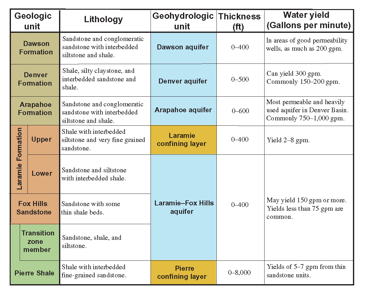
The Dawson Arkose is a geologic formation in the Denver Basin that underlies the Denver area in Colorado. It is characterized by alternating beds of arkosic sandstone and mudstone.Raynolds, R.G. 2002. Upper Cretaceous and Tertiary stratigraphy of the Denver Basin, Colorado. Rocky Mountain Geology, vol. 37, no. 2, p. 111-134. The Dawson Arkose contains plant remains and other nonmarine fossils, and hosts aquifers that are important sources of water for the area.Raynolds, R.G. and Johnson, K.R. 2003. Synopsis of the stratigraphy and paleontology of the uppermost Cretaceous and lower Tertiary strata in the Denver Basin, Colorado. Rocky Mountain Geology, vol. 38, no. 1, p. 171-181. Stratigraphy The Dawson Arkose consists of alluvial fan and fluvial deposits that accumulated at the foot of the growing Rocky Mountain Front ranges. It overlies and interfingers with the Denver Formation which spans the Cretaceous-Paleogene boundary, and is of early Paleocene (Puercan) age.Barclay, R.S., ... [...More Info...] [...Related Items...] OR: [Wikipedia] [Google] [Baidu] |
Formation (stratigraphy)
A geological formation, or simply formation, is a body of rock having a consistent set of physical characteristics (lithology) that distinguishes it from adjacent bodies of rock, and which occupies a particular position in the layers of rock exposed in a geographical region (the stratigraphic column). It is the fundamental unit of lithostratigraphy, the study of strata or rock layers. A formation must be large enough that it can be mapped at the surface or traced in the subsurface. Formations are otherwise not defined by the thickness of their rock strata, which can vary widely. They are usually, but not universally, tabular in form. They may consist of a single lithology (rock type), or of alternating beds of two or more lithologies, or even a heterogeneous mixture of lithologies, so long as this distinguishes them from adjacent bodies of rock. The concept of a geologic formation goes back to the beginnings of modern scientific geology. The term was used by Abraham Gottlob W ... [...More Info...] [...Related Items...] OR: [Wikipedia] [Google] [Baidu] |
Alluvial Fan
An alluvial fan is an accumulation of sediments that fans outwards from a concentrated source of sediments, such as a narrow canyon emerging from an escarpment. They are characteristic of mountainous terrain in arid to semiarid climates, but are also found in more humid environments subject to intense rainfall and in areas of modern glaciation. They range in area from less than to almost . Alluvial fans typically form where flow emerges from a confined channel and is free to spread out and infiltrate the surface. This reduces the carrying capacity of the flow and results in deposition of sediments. The flow can take the form of infrequent debris flows or one or more ephemeral or perennial streams. Alluvial fans are common in the geologic record, such as in the Triassic basins of eastern North America and the New Red Sandstone of south Devon. Such fan deposits likely contain the largest accumulations of gravel in the geologic record. Alluvial fans have also been found on Ma ... [...More Info...] [...Related Items...] OR: [Wikipedia] [Google] [Baidu] |
Paleontology In Colorado
The location of the state of Colorado Paleontology in Colorado refers to paleontological research occurring within or conducted by people from the U.S. state of Colorado. The geologic column of Colorado spans about one third of Earth's history. Fossils can be found almost everywhere in the state but are not evenly distributed among all the ages of the state's rocks. During the early Paleozoic, Colorado was covered by a warm shallow sea that would come to be home to creatures like brachiopods, conodonts, ostracoderms, sharks and trilobites. This sea withdrew from the state between the Silurian and early Devonian leaving a gap in the local rock record. It returned during the Carboniferous. Areas of the state not submerged were richly vegetated and inhabited by amphibians that left behind footprints that would later fossilize. During the Permian, the sea withdrew and alluvial fans and sand dunes spread across the state. Many trace fossils are known from these deposits. The s ... [...More Info...] [...Related Items...] OR: [Wikipedia] [Google] [Baidu] |
List Of Fossiliferous Stratigraphic Units In Colorado
This article contains a list of fossil-bearing stratigraphic units in the state of Colorado, U.S. Sites See also * Paleontology in Colorado References * {{DEFAULTSORT:Fossiliferous stratigraphic units in Colorado Colorado Colorado (, other variants) is a state in the Mountain states, Mountain West subregion of the Western United States. It encompasses most of the Southern Rocky Mountains, as well as the northeastern portion of the Colorado Plateau and the wes ... Stratigraphic units Stratigraphy of Colorado Colorado geography-related lists United States geology-related lists ... [...More Info...] [...Related Items...] OR: [Wikipedia] [Google] [Baidu] |
Arapahoe Formation
The Arapahoe Formation is a geological formation of latest Cretaceous (Maastrichtian) age that is present within the Denver Basin that underlies the Denver, Colorado, area.Tweto, O. 1979. Geologic map of Colorado. U.S. Geological Survey, Map G77115. The formation includes fossil leavesVan Horn, R. 1957. Bedrock geology of the Golden Quadrangle, Colorado. U.S. Geological Survey, Map GQ 103. and dinosaur remains, although none of the latter have yet been referred to a specific genus.Weishampel, et al. (2004). "Dinosaur distribution." Pp. 517-607. It also includes aquifers that are important sources of water for the area.Raynolds, R.G. and Johnson, K.R. 2003. Synopsis of the stratigraphy and paleontology of the uppermost Cretaceous and lower Tertiary strata in the Denver Basin, Colorado. Rocky Mountain Geology, vol. 38, no. 1, p. 171-181. The Arapahoe Formation consists of alluvial fan and fluvial deposits that prograded eastward from the growing Rocky Mountain Front Ranges. It rests ... [...More Info...] [...Related Items...] OR: [Wikipedia] [Google] [Baidu] |
Paleosol
In the geosciences, paleosol (''palaeosol'' in Great Britain and Australia) is an ancient soil that formed in the past. The precise definition of the term in geology and paleontology is slightly different from its use in soil science. In geology and paleontology, a paleosol is a former soil preserved by burial underneath either sediments (alluvium or loess) or volcanic deposits (volcanic ash), which in the case of older deposits have lithified into rock. In Quaternary geology, sedimentology, paleoclimatology, and geology in general, it is the typical and accepted practice to use the term "paleosol" to designate such "''fossil soils''" found buried within sedimentary and volcanic deposits exposed in all continents. In soil science the definition differs only slightly: ''paleosols'' are soils formed long ago that have no relationship in their chemical and physical characteristics to the present-day climate or vegetation. Such soils are found within extremely old continental ... [...More Info...] [...Related Items...] OR: [Wikipedia] [Google] [Baidu] |
Laramie Formation
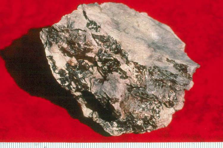
The Laramie Formation is a geologic formation of Late Cretaceous (Maastrichtian) age, named by Clarence King in 1876 for exposures in northeastern Colorado, in the United States.King, C. 1876. Report of the Geological Exploration of the Fortieth Parallel. U.S.Geographical and Geological Survey. It was deposited on a coastal plain and in coastal swamps that flanked the Western Interior Seaway. It contains coal, clay and uranium deposits, as well as plant and animal fossils, including dinosaur remains. Stratigraphy and Lithology The Laramie Formation is exposed around the edges of the Denver Basin and ranges from 400–500 feet (120–150 m) on the western side of the basin, and 200–300 feet (60–90 m) thick on the eastern side. It rests conformably on the Fox Hills Sandstone and unconformably underlies the Arapahoe Conglomerate. The formation can be divided into an unnamed lower member containing bedded sandstone, clay and coal; and an unnamed upper member composed predominat ... [...More Info...] [...Related Items...] OR: [Wikipedia] [Google] [Baidu] |
Facies
In geology, a facies ( , ; same pronunciation and spelling in the plural) is a body of rock with specified characteristics, which can be any observable attribute of rocks (such as their overall appearance, composition, or condition of formation), and the changes that may occur in those attributes over a geographic area. A facies encompasses all of the characteristics of a rock including its chemical, physical, and biological features that distinguish it from adjacent rock. The term facies was introduced by the Swiss geologist Amanz Gressly in 1838 and was part of his significant contribution to the foundations of modern stratigraphy, which replaced the earlier notions of Neptunism. Types of facies Sedimentary facies Ideally, a Sedimentary structures, sedimentary facies is a distinctive rock unit that forms under certain conditions of sedimentation, reflecting a particular process or environment. Sedimentary facies are either descriptive or interpretative. Sedimentary facies ... [...More Info...] [...Related Items...] OR: [Wikipedia] [Google] [Baidu] |
Puercan
The Puercan North American Stage on the geologic timescale is the North American faunal stage according to the North American Land Mammal Ages chronology (NALMA), spanning the interval from 66,000,000 to 63,300,000 years BP lasting . It is usually considered to be within the Paleocene. The Puercan directly follows the Lancian NALMA, with the K-Pg boundary and K-Pg mass extinction at 66 MYA representing the boundary between the two. The Puercan is followed by the Torrejonian NALMA stage. Puercan age fossils, from the Great Divide Basin, Wyoming, include three newly identified condylarth members of the Periptychidae Periptychidae is a family of Paleocene placental mammals, known definitively only from North America. The family is part of a radiation of early herbivorous and omnivorous mammals formerly classified in the extinct order " Condylarthra", which ...; '' Miniconus jeanninae, Conacodon hettingeri, Beornus honeyi'' Substages The Puercan is considered to contai ... [...More Info...] [...Related Items...] OR: [Wikipedia] [Google] [Baidu] |
Denver Formation
The Denver Formation is a geological formation that is present within the central part of the Denver Basin that underlies the Denver, Colorado, area. It ranges in age from latest Cretaceous ( Maastrichtian) to early Paleocene, and includes sediments that were deposited before, during and after the Cretaceous-Paleogene boundary event.Tweto, O. 1979. Geologic map of Colorado. U.S. Geological Survey, Map G77115. The formation is known for its paleontological resources, including dinosaur remains that are found in the Late Cretaceous part of the formation, and it includes aquifers that are important sources of water for the area. Stratigraphy The Denver Formation rests on the Arapahoe Formation, and its base is marked by the first appearance of tuffaceous sediments. It is overlain by the Dawson Arkose. In 2002 the Denver Formation was included as part of a larger unconformity-bounded unit named the D1 sequence, in order to facilitate basin-wide studies and avoid confusion ... [...More Info...] [...Related Items...] OR: [Wikipedia] [Google] [Baidu] |
Rocky Mountain Front
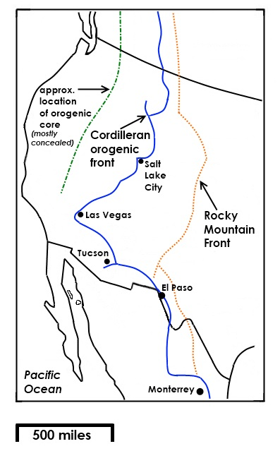
The Rocky Mountain Front is a somewhat unified geologic and ecosystem area in North America where the eastern slopes of the Rocky Mountains meet the plains. In 1983, the Bureau of Land Management called the Rocky Mountain Front "a nationally significant area because of its high wildlife, recreation, and scenic values". Conservationists Gregory Neudecker, Alison Duvall, and James Stutzman have described the Rocky Mountain Front as an area that warrants "the highest of conservation priorities" because it is largely unaltered by development and contains "unparalleled" numbers of wildlife. Defining the Rocky Mountain Front Although the Rocky Mountain Front is clearly distinct from both plains and mountains, in places like the Wyoming Basin, Montana, and New Mexico it is more ambiguous. One definition of the front is that it is a "transition zone between the Rocky Mountains and the mixed grass prairie ... hatencompasses a wide variety of wetland, riparian, grassland, and forested hab ... [...More Info...] [...Related Items...] OR: [Wikipedia] [Google] [Baidu] |


