|
Dalry And North Johnstone Line
The Dalry and North Johnstone Line (also known as the Lochwinnoch Loop Line or Kilbarchan Loop Line) was a branch of the Glasgow and South Western Railway (G&SWR) in Renfrewshire and Ayrshire, Scotland, connecting the stations in Elderslie and Dalry via a route running parallel to the existing line built by the Glasgow, Paisley, Kilmarnock and Ayr Railway. This provided additional line capacity for Ayrshire Coast and Kilmarnock services. The loop line was used for passenger services until the mid-1960s, when it was closed by the Beeching Axe. The majority of the line's trackbed has since been absorbed into the Sustrans National Cycle Network. History The main line to Ayr The Glasgow, Paisley, Kilmarnock and Ayr Railway (GPK&AR) had opened its main line between Glasgow and Ayr in 1839 - 1840. From Paisley the route ran through Johnstone, Dalry and Irvine. Between Glasgow and Paisley, the route was the Glasgow and Paisley Joint Line, operated jointly with the competing Glasgo ... [...More Info...] [...Related Items...] OR: [Wikipedia] [Google] [Baidu] |
Glasgow And South Western Railway
The Glasgow and South Western Railway (G&SWR) was a railway company in Scotland. It served a triangular area of south-west Scotland between Glasgow, Stranraer and Carlisle. It was formed on 28 October 1850 by the merger of two earlier railways, the Glasgow, Paisley, Kilmarnock and Ayr Railway and the Glasgow, Dumfries and Carlisle Railway. Already established in Ayrshire, it consolidated its position there and extended southwards, eventually reaching Stranraer. Its main business was mineral traffic, especially coal, and passengers, but its more southerly territory was very thinly populated and local traffic, passenger and goods, was limited, while operationally parts of its network were difficult. It later formed an alliance with the English Midland Railway and ran express passenger trains from Glasgow to London with that company, in competition with the Caledonian Railway and its English partner, the London and North Western Railway, who had an easier route. In 1923 the G&S ... [...More Info...] [...Related Items...] OR: [Wikipedia] [Google] [Baidu] |
Bridge Of Weir Railway
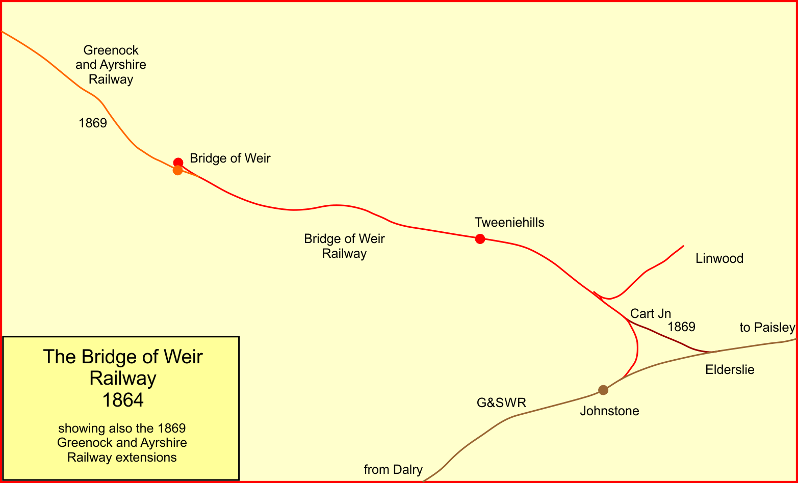
The Bridge of Weir Railway was an independent railway company that built a line from Johnstone to Bridge of Weir. It was taken over by the Glasgow and South Western Railway (G&SWR) in 1865 and formed the base of a line that extended to Greenock, giving the G&SWR access to the harbour facilities there, competing with the rival Caledonian Railway. The Greenock branch, as it had become, was given a direct access from Elderslie (about midway between Paisley and Johnstone), and fast passenger trains ran between Glasgow and Greenock. In the second half of the twentieth century usage of the line declined substantially, and the line closed in January 1983. Formation By the 1860s the Glasgow and South Western Railway (G&SWR) had established itself in the south-western quadrant of Scotland, while the rival Caledonian Railway was dominant in the central region, with an important branch line to Greenock. There was bitter rivalry between the two companies, and each sought to retain prim ... [...More Info...] [...Related Items...] OR: [Wikipedia] [Google] [Baidu] |
Closed Railway Lines In Scotland
Closed may refer to: Mathematics * Closure (mathematics), a set, along with operations, for which applying those operations on members always results in a member of the set * Closed set, a set which contains all its limit points * Closed interval, an interval which includes its endpoints * Closed line segment, a line segment which includes its endpoints * Closed manifold, a compact manifold which has no boundary Other uses * Closed (poker), a betting round where no player will have the right to raise * ''Closed'' (album), a 2010 album by Bomb Factory * Closed GmbH, a German fashion brand * Closed class, in linguistics, a class of words or other entities which rarely changes See also * * Close (other) * Closed loop (other) * Closing (other) * Closure (other) * Open (other) Open or OPEN may refer to: Music * Open (band), Australian pop/rock band * The Open (band), English indie rock band * ''Open'' (Blues Image album), 1969 * ''O ... [...More Info...] [...Related Items...] OR: [Wikipedia] [Google] [Baidu] |
Glasgow
Glasgow ( ; sco, Glesca or ; gd, Glaschu ) is the most populous city in Scotland and the fourth-most populous city in the United Kingdom, as well as being the 27th largest city by population in Europe. In 2020, it had an estimated population of 635,640. Straddling the border between historic Lanarkshire and Renfrewshire, the city now forms the Glasgow City Council area, one of the 32 council areas of Scotland, and is governed by Glasgow City Council. It is situated on the River Clyde in the country's West Central Lowlands. Glasgow has the largest economy in Scotland and the third-highest GDP per capita of any city in the UK. Glasgow's major cultural institutions – the Burrell Collection, Kelvingrove Art Gallery and Museum, the Royal Conservatoire of Scotland, the Royal Scottish National Orchestra, Scottish Ballet and Scottish Opera – enjoy international reputations. The city was the European Capital of Culture in 1990 and is notable for its architecture, cult ... [...More Info...] [...Related Items...] OR: [Wikipedia] [Google] [Baidu] |
Inverness
Inverness (; from the gd, Inbhir Nis , meaning "Mouth of the River Ness"; sco, Innerness) is a city in the Scottish Highlands. It is the administrative centre for The Highland Council and is regarded as the capital of the Highlands. Historically it served as the county town of the county of Inverness-shire. Inverness lies near two important battle sites: the 11th-century battle of Blàr nam Fèinne against Norway which took place on the Aird, and the 18th century Battle of Culloden which took place on Culloden Moor. It is the northernmost city in the United Kingdom and lies within the Great Glen (Gleann Mòr) at its northeastern extremity where the River Ness enters the Beauly Firth. At the latest, a settlement was established by the 6th century with the first royal charter being granted by Dabíd mac Maíl Choluim (King David I) in the 12th century. Inverness and Inverness-shire are closely linked to various influential clans, including Clan Mackintosh, Clan Fraser and Cl ... [...More Info...] [...Related Items...] OR: [Wikipedia] [Google] [Baidu] |
Carlisle Railway Station
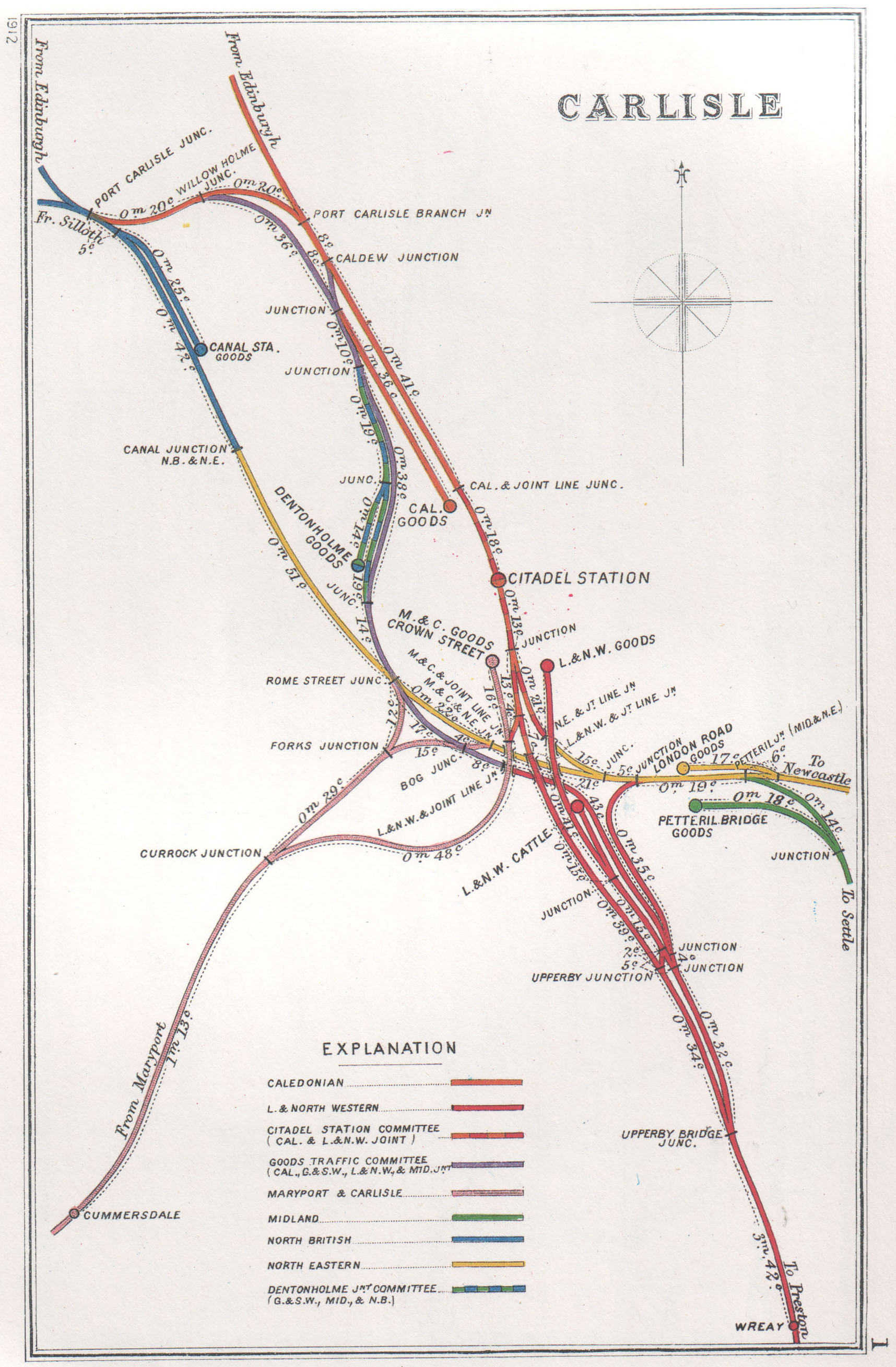
Carlisle railway station, or Carlisle Citadel, is a Grade II* listed railway station serving the city of Carlisle, Cumbria, England. It is on the West Coast Main Line, south-east of and north north-west of . It is the northern terminus of the Settle and Carlisle Line, a continuation of the Midland Main Line from , and . It was formerly the southern terminus of the partially-closed Waverley Route from Edinburgh. It is so named because it is adjacent to Carlisle Citadel, a former medieval fortress. The station is owned by Network Rail. In September 1847, the first services departed the station, even though construction was not completed until the following year. It was built in a neo- Tudor style to the designs of English architect William Tite. Carlisle station was one of a number in the city; the others were Crown Street and London Road, but it became the dominant station by 1851. The other stations had their passenger services redirected to it and were closed. Between 1 ... [...More Info...] [...Related Items...] OR: [Wikipedia] [Google] [Baidu] |
NCR 7
Route For mapping purposes, the route is split at Glasgow into Lochs and Glens (south) and (north) Sunderland to Carlisle This route follows the Sea to Sea (C2C) cycle route for much of its length before the C2C departs to Whitehaven and NCN7 continues to Carlisle. Carlisle to Glasgow The route runs from Carlisle across the border to Dumfries; this section takes a long route at present, but may change following the construction of an "all-purpose route" alongside the M6 extension. In Scotland, the route then heads west to Dumfries and then Newton Stewart. At this point, it does not use the route of the abandoned Portpatrick and Wigtownshire Joint Railway. It then splits into alternative on and off-road paths to run north through hilly country to meet the coast again at Ayr. After meeting the NCN 73 near Kilwinning, it follows back roads and an old railway, meets the NCN 75 west of Paisley, which run together into Glasgow, with 7 and 75 splitting outside the Scottish ... [...More Info...] [...Related Items...] OR: [Wikipedia] [Google] [Baidu] |
Largs
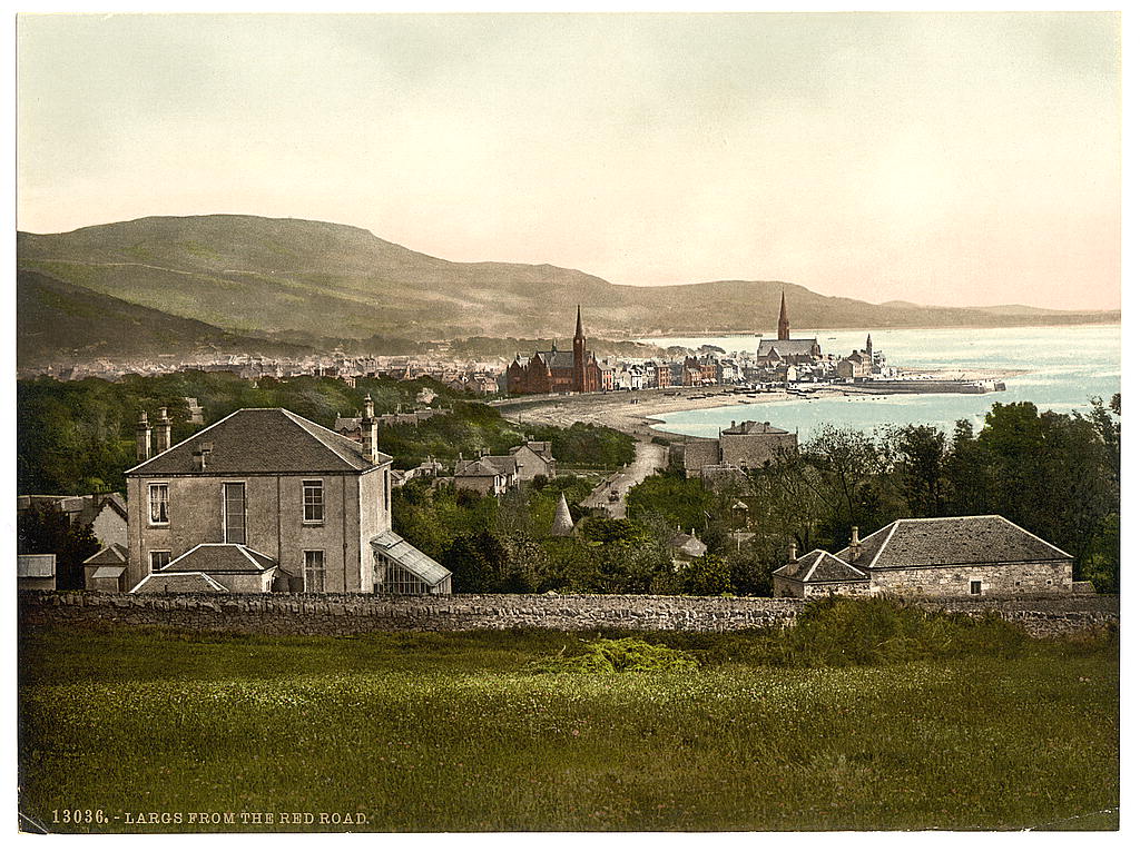
Largs ( gd, An Leargaidh Ghallda) is a town on the Firth of Clyde in North Ayrshire, Scotland, about from Glasgow. The original name means "the slopes" (''An Leargaidh'') in Scottish Gaelic. A popular seaside resort with a pier, the town markets itself on its historic links with the Vikings and an annual festival is held each year in early September. In 1263 it was the site of the Battle of Largs between the Norwegian and the Scottish armies. The National Mòd has also been held here in the past. History There is evidence of human activity in the vicinity of Largs which can be dated to the Neolithic era. The Haylie Chambered Tomb in Douglas Park dates from c. 3000 BC. Largs evolved from the estates of North Cunninghame over which the Montgomeries of Skelmorlie became temporal lords in the seventeenth century. Sir Robert Montgomerie built Skelmorlie Aisle in the ancient kirk of Largs in 1636 as a family mausoleum. Today the monument is all that remains of the old kirk. ... [...More Info...] [...Related Items...] OR: [Wikipedia] [Google] [Baidu] |
Ardrossan
Ardrossan (; ) is a town on the North Ayrshire coast in southwestern Scotland. The town has a population of 10,670 and forms part of a conurbation with Saltcoats and Stevenston known as the 'Three Towns'. Ardrossan is located on the east shore of the Firth of Clyde. History Ardrossan's roots can be traced to the construction of its castle 'Cannon Hill', thought to be in around 1140, by Simon de Morville. The castle and estate passed to the Barclay family (also known as Craig) and through successive heirs until the 14th century when it passed to the Eglinton family on the death of Godfrey Barclay de Ardrossan, who died without an heir. Sir Fergus Barclay, Baron of Ardrossan, was said to be in league with the Devil and in one of his dealings, set the task for the Devil to make ropes from sand; on failing to do so, the Devil kicked the castle with his hoof in frustration and left a petrosomatoglyph hoofprint.Ardrossan & Neighbourhood. Guide. 1920s. pp. 29–30. The castle sto ... [...More Info...] [...Related Items...] OR: [Wikipedia] [Google] [Baidu] |
St Enoch Railway Station
St Enoch station was a mainline railway station in the city of Glasgow, Scotland between 1876 and 1966. The hotel was the first building in Glasgow to be fitted out with electric lighting. The station was demolished in 1977. History Located on St Enoch Square in the city centre, it was opened by the City of Glasgow Union Railway in 1876.Butt (1995), page 103Thomas (1971) The first passenger train stopped there on 1 May 1876 and the official opening took place on 17 October 1876. In 1883 it was taken over by the Glasgow and South Western Railway (G&SWR) and it became their headquarters. Services ran to most parts of the G&SWR system, including , , , and . In partnership with the Midland Railway, through services also ran to England, using the Settle and Carlisle Railway from Carlisle to , , and ; the so-called Thames-Clyde route. It was the site of a rail crash in 1903 in which 16 passengers were killed and 64 injured when a train overran the buffers. In the 1923 grou ... [...More Info...] [...Related Items...] OR: [Wikipedia] [Google] [Baidu] |
Johnstone Rlies 1906
Johnstone ( sco, Johnstoun, gd, Baile Iain) is a town in the of Renfrewshire and larger historic county of the same name, in the west central Lowlands of |
Kilbirnie Loch
Kilbirnie Loch (NS 330 543), is a freshwater Loch situated in the floodplain between Kilbirnie, Glengarnock and Beith, North Ayrshire, Scotland. It runs south-west to north-east for almost , is about wide for the most part and has an area of roughly 3 km2 (761 acres). It has a general depth of around 5.2 metres (17 feet) to a maximum of around 11 metres (36 feet). The loch is fed mainly by the Maich Water, which rises in the Kilbirnie Hills near Misty Law (507m or 1663 feet), and is drained by the Dubbs Water that runs past the Barr Loch into Castle Semple Loch, followed by the Black Cart, the White Cart at Renfrew and finally the River Clyde. The boundary between East Renfrewshire and North Ayrshire, in the vicinity of the loch, runs down the course of the Maich Water along the northern loch shore to then run up beside the Dubbs Water. History Origins and placenames Hector Boece (1465–1536) is the first to publish a reference to the loch, using the na ... [...More Info...] [...Related Items...] OR: [Wikipedia] [Google] [Baidu] |


.jpg)

