|
Daigo, Ibaraki
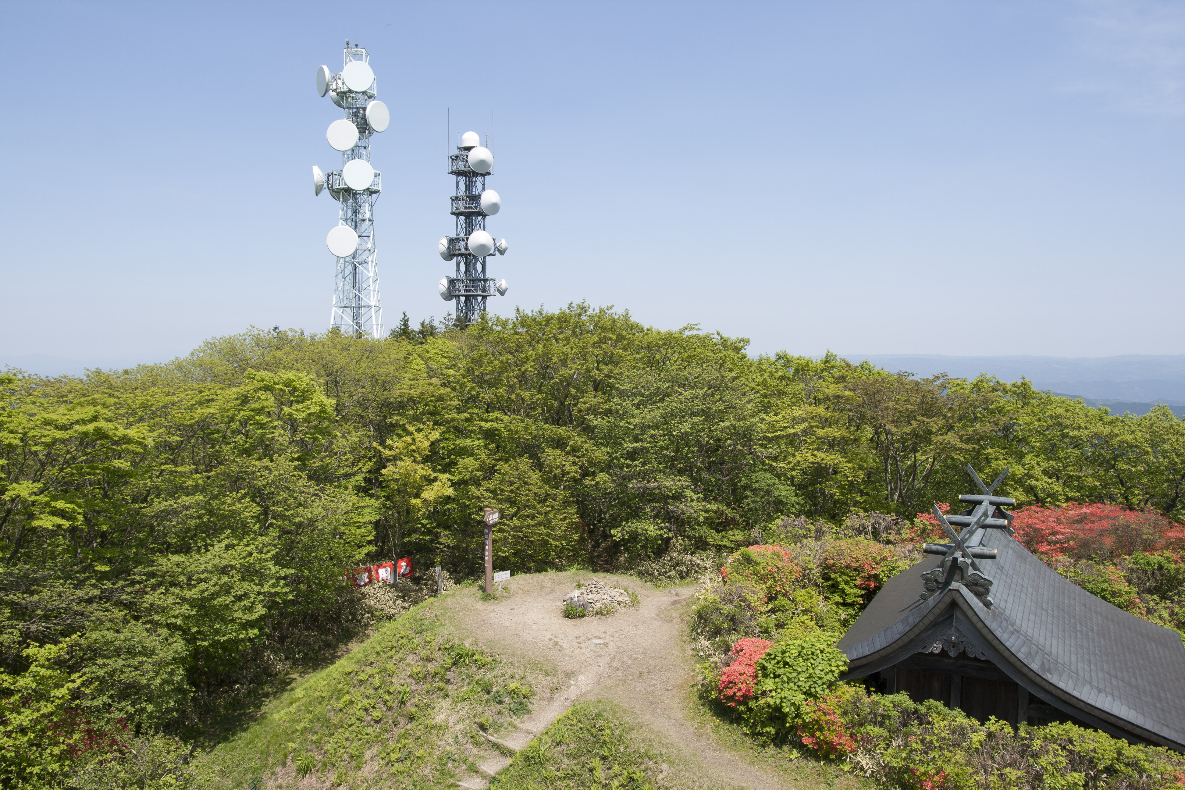
250px, Kuji River in Daigo 250px, Fukuroda Falls is a town located in Ibaraki Prefecture, Japan. , the town had an estimated population of 15,771 in 6431 households and a population density of . The percentage of the population aged over 65 was 46.6%. The total area of the town is . Geography Located in northwestern Ibaraki Prefecture along the upper reaches of the Kuji River, Daigo is bordered to the north by Fukushima Prefecture and to the west by Tochigi Prefecture. Surrounding municipalities Ibaraki Prefecture * Hitachiōta * Hitachiōmiya Fukushima Prefecture * Yamatsuri * Tanagura Tochigi Prefecture *Ōtawara * Nakagawa Climate Although the altitude is relatively low at 120 meters, Daigo is very chilly in the morning and evening in winter because it is located in a basin. The average minimum temperature of minus 5.5 ℃ in January is almost the same as Morioka, Iwate, much further north, and Daigo is known for having some of the coldest winters in the Kantō region. Ho ... [...More Info...] [...Related Items...] OR: [Wikipedia] [Google] [Baidu] |
Towns Of Japan
A town (町; ''chō'' or ''machi'') is a local administrative unit in Japan. It is a local public body along with prefecture (''ken'' or other equivalents), city (''shi''), and village (''mura''). Geographically, a town is contained within a district. Note that the same word (町; ''machi'' or ''chō'') is also used in names of smaller regions, usually a part of a ward in a city. This is a legacy of when smaller towns were formed on the outskirts of a city, only to eventually merge into it. Towns See also * Municipalities of Japan * Japanese addressing system The Japanese addressing system is used to identify a specific location in Japan. When written in Japanese characters, addresses start with the largest geographical entity and proceed to the most specific one. When written in Latin characters, ad ... References {{reflist External links "Large_City_System_of_Japan";_graphic_shows_towns_compared_with_other_Japanese_city_types_at_p._1_[PDF_7_of_40/nowiki>">DF_7_of_4 ... [...More Info...] [...Related Items...] OR: [Wikipedia] [Google] [Baidu] |
Kuji River
is a river in Fukushima Prefecture, Tochigi Prefecture and Ibaraki Prefecture, Japan. It rises at the northern slope of Mount Yamizo, where the border of these three prefectures is located, and flows into Pacific Ocean at Hitachi and Tokai in Ibaraki Prefecture. It has a length of and a drainage area of , and is designated as a Class A river. The name of ''Kuji'' is thought to have been named after whale (''kujira'' in Japanese). ', one of the existent ''Fudoki'', says, "There were a hill that resembled a whale (''kujira''). Then the emperor named the land ''Kuji''." The river is known for ayu fishing, and in 2006 it had the second largest catch of ayu in Japan after Naka River, which is also located in Ibaraki Prefecture. The fishing weir (梁 ''yana'') for tourists is installed along the river in Daigo. Famous Fukuroda Falls are located on Taki River (滝川 ''Takigawa''), which is one of its tributary rivers. On midwinter a phenomenon called ' can be observed in the ... [...More Info...] [...Related Items...] OR: [Wikipedia] [Google] [Baidu] |
Diet Of Japan
The is the national legislature of Japan. It is composed of a lower house, called the House of Representatives (, ''Shūgiin''), and an upper house, the House of Councillors (, '' Sangiin''). Both houses are directly elected under a parallel voting system. In addition to passing laws, the Diet is formally responsible for nominating the Prime Minister. The Diet was first established as the Imperial Diet in 1890 under the Meiji Constitution, and took its current form in 1947 upon the adoption of the post-war constitution. Both houses meet in the in Nagatachō, Chiyoda, Tokyo. Composition The houses of the National Diet are both elected under parallel voting systems. This means that the seats to be filled in any given election are divided into two groups, each elected by a different method; the main difference between the houses is in the sizes of the two groups and how they are elected. Voters are also asked to cast two votes: one for an individual candidate in a const ... [...More Info...] [...Related Items...] OR: [Wikipedia] [Google] [Baidu] |
House Of Representatives Of Japan
The is the lower house of the National Diet of Japan. The House of Councillors (Japan), House of Councillors is the upper house. The composition of the House is established by and of the Constitution of Japan. The House of Representatives has 465 members, elected for a four-year term. Of these, 176 members are elected from 11 multi-member constituencies by a party-list system of proportional representation, and 289 are elected from single-member constituencies. The overall voting system used to elect the House of Representatives is a Parallel voting, parallel system, a form of semi-proportional representation. Under a parallel system the allocation of list seats does not take into account the outcome in the single seat constituencies. Therefore, the overall allocation of seats in the House of Representatives is not proportional, to the advantage of larger parties. In contrast, in bodies such as the German ''Bundestag'' or the New Zealand Parliament the election of single-seat ... [...More Info...] [...Related Items...] OR: [Wikipedia] [Google] [Baidu] |
Ibaraki 5th District
, the House of Representatives of Japan is elected from a combination of multi-member districts and single-member districts, a method called Parallel voting. Currently, 176 members are elected from 11 multi-member districts (called proportional representation blocks or PR blocks) by a party-list system of proportional representation (PR), and 289 members are elected from single-member districts, for a total of 465. 233 seats are therefore required for a majority. Each PR block consists of one or more prefectures, and each prefecture is divided into one or more single-member districts. In general, the block districts correspond loosely to the major regions of Japan, with some of the larger regions (such as Kantō) subdivided. History Until the 1993 general election, all members of the House of Representatives were elected in multi-member constituencies by single non-transferable vote. In 1994, Parliament passed an electoral reform bill that introduced the current system of pa ... [...More Info...] [...Related Items...] OR: [Wikipedia] [Google] [Baidu] |
Unicameral
Unicameralism (from ''uni''- "one" + Latin ''camera'' "chamber") is a type of legislature, which consists of one house or assembly, that legislates and votes as one. Unicameral legislatures exist when there is no widely perceived need for multicameralism (two or more chambers). Many multicameral legislatures were created to give separate voices to different sectors of society. Multiple houses allowed, for example, for a guaranteed representation of different social classes (as in the Parliament of the United Kingdom or the French States-General). Sometimes, as in New Zealand and Denmark, unicameralism comes about through the abolition of one of two bicameral chambers, or, as in Sweden, through the merger of the two chambers into a single one, while in others a second chamber has never existed from the beginning. Rationale for unicameralism and criticism The principal advantage of a unicameral system is more efficient lawmaking, as the legislative process is simpler and there is ... [...More Info...] [...Related Items...] OR: [Wikipedia] [Google] [Baidu] |
Japan Meteorological Agency
The , abbreviated JMA, is an agency of the Ministry of Land, Infrastructure, Transport and Tourism. It is charged with gathering and providing results for the public in Japan that are obtained from data based on daily scientific observation and research into natural phenomena in the fields of meteorology, hydrology, seismology and volcanology, among other related scientific fields. Its headquarters is located in Minato, Tokyo. JMA is responsible for gathering and reporting weather data and forecasts for the general public, as well as providing aviation and marine weather. JMA other responsibilities include issuing warnings for volcanic eruptions, and the nationwide issuance of earthquake warnings of the Earthquake Early Warning (EEW) system. JMA is also designated one of the Regional Specialized Meteorological Centers of the World Meteorological Organization (WMO). It is responsible for forecasting, naming, and distributing warnings for tropical cyclones in the Northwestern ... [...More Info...] [...Related Items...] OR: [Wikipedia] [Google] [Baidu] |
Morioka, Iwate
is the capital city of Iwate Prefecture located in the Tōhoku region of northern Japan. On 1 February 2021, the city had an estimated population of 290,700 in 132,719 households, and a population density of . The total area of the city is . Geography Morioka is located in the in central Iwate Prefecture, at the confluence of three rivers, the Kitakami, the Shizukuishi and the Nakatsu. The Kitakami River is the second largest river on the Pacific side of Japan (after the Tone River) and the longest in the Tōhoku region. It runs through the city from north to south and has a number of dams within the city boundaries, including the Shijūshida Dam and Gandō Dam. An active volcano, Mount Iwate, dominates the view to the northwest of the city. Mount Himekami is to the north and Mount Hayachine can sometimes be seen to the southeast. Surrounding municipalities Iwate Prefecture *Hanamaki * Hachimantai * Takizawa * Miyako *Shizukuishi * Kuzumaki * Shiwa *Yahaba * Iwaizumi Demogr ... [...More Info...] [...Related Items...] OR: [Wikipedia] [Google] [Baidu] |
Nakagawa, Tochigi
file:Bato Hiroshige Museum 2009.jpg, 270px, Bato Hiroshige Museum is a List of towns in Japan, town located in Tochigi Prefecture, Japan. , the town had an estimated population of 15,824 in 6,028 households, and a population density of 82 persons per km². Its total area of the town is . On October 4, 2013, a portion of the town was designated one of The Most Beautiful Villages in Japan. Geography Nakagawa is located in northeast Tochigi Prefecture. Surrounding municipalities Tochigi Prefecture * Ōtawara, Tochigi, Ōtawara * Nasukarasuyama, Tochigi, Nasukarasuyama * Sakura, Tochigi, Sakura Ibaraki Prefecture * Hitachiōmiya, Ibaraki, Hitachiōmiya * Daigo, Ibaraki, Daigo Climate Nakagawa has a humid continental climate (Köppen ''Cfa'') characterized by warm summers and cold winters with heavy snowfall. The average annual temperature in Nakagawa is 12.8 °C. The average annual rainfall is 1418 mm with September as the wettest month. The temperatures are highest on av ... [...More Info...] [...Related Items...] OR: [Wikipedia] [Google] [Baidu] |
Tanagura, Fukushima
file:Tanakura Castle hori.JPG, 270px, Site of Tanagura Castle is a Towns of Japan, town located in Fukushima Prefecture, Japan. , the town had an estimated population of 13,827 in 5053 households, and a population density of 86 persons per km². The total area of the town was . Geography Tanagura is located in the southernmost portion of Fukushima prefecture, bordering on Tochigi Prefecture to the west and Ibaraki Prefecture to the south. *Mountains: Yamizosan (1021.8m) *Rivers: Kuji River Neighboring municipalities * Fukushima Prefecture ** Shirakawa, Fukushima, Shirakawa ** Yamatsuri, Fukushima, Yamatsuri ** Samegawa, Fukushima, Samegawa ** Asakawa, Fukushima, Asakawa ** Hanawa, Fukushima, Hanawa *Ibaraki Prefecture ** Daigo, Ibaraki, Daigo *Tochigi Prefecture ** Ōtawara, Tochigi, Ōtawara ** Nasu, Tochigi, Nasu Demographics Per Japanese census data, the population of Tanagura was relatively constant throughout the late 20th century but has begun to decline in the 21st. Ta ... [...More Info...] [...Related Items...] OR: [Wikipedia] [Google] [Baidu] |


