|
Cusseta Tribal Town
Cusseta, also known as Kasihta, was a Peace Town of the Lower Towns, a division of the Muscogee Confederacy. It was located in what the Spanish called Apalachicola Province on the Chattahoochee River, then in what is now the state of Georgia near the Ocmulgee River, and finally again on the Chattahoochee River."History." ''Unified Government Offices of Cusseta-Chattahoochee County.'' 2004. Retrieved 20 Aug 2012. It was one of the two major towns of the Lower Creek, with a population of 1,918 in 1832. Origins According to Muscogee , early Creek from Ocmulgee settled Cusseta and |
Muscogee
The Muscogee, also known as the Mvskoke, Muscogee Creek, and the Muscogee Creek Confederacy ( in the Muscogee language), are a group of related indigenous (Native American) peoples of the Southeastern WoodlandsTranscribed documents Sequoyah Research Center and the American Native Press Archives in the . Their original homelands are in what now comprises southern , much of , western |
Treaty Of Cusseta
The Treaty of Cusseta was a treaty between the government of the United States and the Creek Nation signed March 24, 1832 (). The treaty ceded all Creek claims east of the Mississippi River to the United States. Origins The Treaty of Cusseta, also known as the Third Treaty of Washington, was one of several with the "Five Civilized Tribes." Between 1814 and 1830, the Creek had gradually ceded lands under pressure from European-American settlers and the US government through treaties such as the Treaty of Fort Jackson and the Treaty of Washington (1826). Creek territory was constrained to a strip in east central Alabama along the Georgia border. President Andrew Jackson had signed the Indian Removal Act in 1830, which ultimately led to the deportation of native peoples in the Southeastern United States to the Indian Territory west of the Mississippi River. Although treaty stipulations had prohibited white settlement of Creek lands, squatters moving into the territory were co ... [...More Info...] [...Related Items...] OR: [Wikipedia] [Google] [Baidu] |
Muscogee Tribal Towns
The Muscogee, also known as the Mvskoke, Muscogee Creek, and the Muscogee Creek Confederacy ( in the Muscogee language), are a group of related indigenous (Native American) peoples of the Southeastern WoodlandsTranscribed documents Sequoyah Research Center and the American Native Press Archives in the . Their original homelands are in what now comprises southern , much of , western |
Cusseta, Alabama
Cusseta is a town in Chambers County, Alabama, United States. Situated between Opelika and Lanett, it was named for the ancient Creek Indian town of Cusseta. As of the 2010 census, its population was 123. Pat Garrett, the lawman famed for killing the outlaw Billy the Kid, was born near Cusseta in 1850. The community was believed to be unincorporated until 2006, when rediscovered documents indicated that Cusseta had been incorporated as a city in 1853. As the community diminished in size over the years, its status was forgotten.Brock Parker, "Cusseta: Alabama's Forgotten City," Sept. 23, 2006, available aWTVM.com/ref> Demographics See also *Fort Cusseta Fort Cusseta was a wooden stockade built by white settlers to protect against feared Creek Indian attacks. Its ruins still exist today within the small community of Cusseta, Alabama. Following the signing of the Treaty of Cusseta The Treaty ... References {{authority control Towns in Alabama Populated ... [...More Info...] [...Related Items...] OR: [Wikipedia] [Google] [Baidu] |
Cusseta, Georgia
Cusseta ( ) is a city in Chattahoochee County, Georgia, United States. It is part of the Columbus, Georgia-Alabama Metropolitan Statistical Area. The population was 11,267 at the 2010 census. The city is the county seat of Chattahoochee County, with which it shares a consolidated city-county government. Despite this, Cusseta is not coterminous with the county; it remains a geographically distinct municipality within the county. History Chattahoochee County was created by an act of the Georgia General Assembly on February 13, 1854. It was formed from portions of Muscogee and Marion counties and named for the river that forms its western boundary. The act appointed five commissioners to choose a site for the county seat, which they named Cusseta to commemorate the Creek Indian town that used to exist nearby. The original courthouse is preserved at the tourist attraction of Westville in Columbus, Georgia. Cusseta was incorporated as a city on December 22, 1855. It is still the ... [...More Info...] [...Related Items...] OR: [Wikipedia] [Google] [Baidu] |
Fort Benning
Fort Benning is a United States Army post near Columbus, Georgia, adjacent to the Alabama–Georgia border. Fort Benning supports more than 120,000 active-duty military, family members, reserve component soldiers, retirees and civilian employees on a daily basis. It is a power projection platform, and possesses the capability to deploy combat-ready forces by air, rail, and highway. Fort Benning is the home of the United States Army Maneuver Center of Excellence, the United States Army Armor School, United States Army Infantry School, the Western Hemisphere Institute for Security Cooperation (formerly known as the School of the Americas), elements of the 75th Ranger Regiment, the 1st Security Force Assistance Brigade, and other tenant units. It is named after Henry L. Benning, a brigadier general in the Confederate States Army during the Civil War. Fort Benning is one of ten U.S. Army installations named for former Confederate generals. The National Defense Authorization Act f ... [...More Info...] [...Related Items...] OR: [Wikipedia] [Google] [Baidu] |
Lawson Army Airfield
Lawson Army Airfield is a military airport located at Fort Benning in Chattahoochee County, Georgia, south of the city of Columbus, Georgia. It is Fort Benning's primary Force Projection Platform. Facilities Lawson Army Airfield has one runway: * Runway 15/33: 10,000 ft. x 150 ft. (3,048 x 46 m), Surface: Asphalt History Origins In late 1918, the U.S. Army established a new camp for the Infantry School of Arms south of Columbus on the Bussey Plantation. The camp was named in honor of Henry Lewis Benning, a Columbus native who served as a Confederate general during the American Civil War and later as a justice of the Georgia Supreme Court. The Army created a rudimentary landing field at Benning in 1919 with the initial mission of determining if data obtained by balloon observation would benefit the infantry. The airfield consisted of two small hangars that housed the balloon unit. In 1922, the Army made the facility a permanent Army post renaming the camp For ... [...More Info...] [...Related Items...] OR: [Wikipedia] [Google] [Baidu] |
Indian Territory
The Indian Territory and the Indian Territories are terms that generally described an evolving land area set aside by the Federal government of the United States, United States Government for the relocation of Native Americans in the United States, Native Americans who held aboriginal title to their land as a sovereign independent state. In general, the tribes ceded land they occupied in exchange for Land grant#United States, land grants in 1803. The concept of an Indian Territory was an outcome of the US federal government's 18th- and 19th-century policy of Indian removal. After the Indian Territory in the American Civil War, American Civil War (1861–1865), the policy of the US government was one of Cultural assimilation of Native Americans#Americanization and assimilation (1857–1920), assimilation. The term ''Indian Reserve (1763), Indian Reserve'' describes lands the Kingdom of Great Britain, British set aside for Indigenous tribes between the Appalachian Mountains and t ... [...More Info...] [...Related Items...] OR: [Wikipedia] [Google] [Baidu] |
Mississippi River
The Mississippi River is the second-longest river and chief river of the second-largest drainage system in North America, second only to the Hudson Bay drainage system. From its traditional source of Lake Itasca in northern Minnesota, it flows generally south for to the Mississippi River Delta in the Gulf of Mexico. With its many tributaries, the Mississippi's watershed drains all or parts of 32 U.S. states and two Canadian provinces between the Rocky and Appalachian mountains. The main stem is entirely within the United States; the total drainage basin is , of which only about one percent is in Canada. The Mississippi ranks as the thirteenth-largest river by discharge in the world. The river either borders or passes through the states of Minnesota, Wisconsin, Iowa, Illinois, Missouri, Kentucky, Tennessee, Arkansas, Mississippi, and Louisiana. Native Americans have lived along the Mississippi River and its tributaries for thousands of years. Most were hunter-ga ... [...More Info...] [...Related Items...] OR: [Wikipedia] [Google] [Baidu] |
Indian Removal
Indian removal was the United States government policy of forced displacement of self-governing tribes of Native Americans from their ancestral homelands in the eastern United States to lands west of the Mississippi Riverspecifically, to a designated Indian Territory (roughly, present-day Oklahoma). The Indian Removal Act, the key law which authorized the removal of Native tribes, was signed by Andrew Jackson in 1830. Although Jackson took a hard line on Indian removal, the law was enforced primarily during the Martin Van Buren administration. After the passage of the Indian Removal Act in 1830, approximately 60,000 members of the Cherokee, Muscogee (Creek), Seminole, Chickasaw, and Choctaw nations (including thousands of their black slaves) were forcibly removed from their ancestral homelands, with thousands dying during the Trail of Tears. Indian removal, a popular policy among incoming settlers, was a consequence of actions by European settlers in North America during th ... [...More Info...] [...Related Items...] OR: [Wikipedia] [Google] [Baidu] |
Apalachicola People
Apalachicola (sometimes Palachacola) was the name of a Native American town and chiefdom, and of the people living in it, and of a group of towns associated with it, located along the lower part of the Chattahoochee River in present-day Alabama and Georgia. The Spanish called the association of towns the Apalachicola Province. It is believed that before the 17th century, the residents of all the Apalachicola towns spoke the Hitchiti language, although other towns whose people spoke Muscogee relocated among the Apalachicolas along the Chattahoochee River in the middle- to later- 17th century. All of the Apalachicola towns moved to central Georgia at the end of the 17th century, where the English called them "Ochese Creek Indians". They moved back to the Chattahoochee River after 1715, with the English then calling them "Lower Creeks" ("Lower Towns of the Muscogee Confederacy"), while the Spanish called them "Ochese". Origins In the first half of the 17th century, a number of tow ... [...More Info...] [...Related Items...] OR: [Wikipedia] [Google] [Baidu] |
Yamasee War
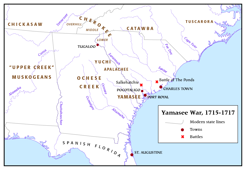
The Yamasee War (also spelled Yamassee or Yemassee) was a conflict fought in South Carolina from 1715 to 1717 between British settlers from the Province of Carolina and the Yamasee and a number of other allied Native American peoples, including the Muscogee, Cherokee, Catawba, Apalachee, Apalachicola, Yuchi, Savannah River Shawnee, Congaree, Waxhaw, Pee Dee, Cape Fear, Cheraw, and others. Some of the Native American groups played a minor role, while others launched attacks throughout South Carolina in an attempt to destroy the colony. Native Americans killed hundreds of colonists and destroyed many settlements, and they killed traders throughout the southeastern region. Colonists abandoned the frontiers and fled to Charles Town, where starvation set in as supplies ran low. The survival of the South Carolina colony was in question during 1715. The tide turned in early 1716 when the Cherokee sided with the colonists against the Creek, their traditional enemy. The la ... [...More Info...] [...Related Items...] OR: [Wikipedia] [Google] [Baidu] |


