|
Convoy PQ 13
PQ 13 was a British Arctic convoy that delivered war supplies from the Western Allies to the USSR during World War II. The convoy was subject to attack by German air, U-boat and surface forces and suffered the loss of five ships, plus one escort vessel. Fifteen ships arrived safely. Ships PQ 13 comprised 19 merchant ships; seven British, four American, one Polish, four of Panamanian and one of Honduran registry. It was commanded by Commodore D. A. Casey in ''River Afton''. The convoy was escorted for the first stage of its voyage, from Scotland to Iceland, by a Local Escort Group, of two destroyers and an ASW Trawler. For the second stage, from Iceland to the Soviet Union, the Ocean escort was two destroyers and two trawlers, augmented by three whalers being transferred to the Soviet Navy. The Ocean escort was commanded by Capt. L. S. Saunders, in the cruiser . In support of the convoy escort, and guarding against a sortie by the , was a Heavy Cover Force, comprising the battles ... [...More Info...] [...Related Items...] OR: [Wikipedia] [Google] [Baidu] |
World War II
World War II or the Second World War, often abbreviated as WWII or WW2, was a world war that lasted from 1939 to 1945. It involved the vast majority of the world's countriesŌĆöincluding all of the great powersŌĆöforming two opposing military alliances: the Allies and the Axis powers. World War II was a total war that directly involved more than 100 million personnel from more than 30 countries. The major participants in the war threw their entire economic, industrial, and scientific capabilities behind the war effort, blurring the distinction between civilian and military resources. Aircraft played a major role in the conflict, enabling the strategic bombing of population centres and deploying the only two nuclear weapons ever used in war. World War II was by far the deadliest conflict in human history; it resulted in 70 to 85 million fatalities, mostly among civilians. Tens of millions died due to genocides (including the Holocaust), starvation, ma ... [...More Info...] [...Related Items...] OR: [Wikipedia] [Google] [Baidu] |
Scotland
Scotland (, ) is a country that is part of the United Kingdom. Covering the northern third of the island of Great Britain, mainland Scotland has a border with England to the southeast and is otherwise surrounded by the Atlantic Ocean to the north and west, the North Sea to the northeast and east, and the Irish Sea to the south. It also contains more than 790 islands, principally in the archipelagos of the Hebrides and the Northern Isles. Most of the population, including the capital Edinburgh, is concentrated in the Central BeltŌĆöthe plain between the Scottish Highlands and the Southern UplandsŌĆöin the Scottish Lowlands. Scotland is divided into 32 administrative subdivisions or local authorities, known as council areas. Glasgow City is the largest council area in terms of population, with Highland being the largest in terms of area. Limited self-governing power, covering matters such as education, social services and roads and transportation, is devolved from the Scott ... [...More Info...] [...Related Items...] OR: [Wikipedia] [Google] [Baidu] |
Minesweeper (ship)
A minesweeper is a small warship designed to remove or detonate naval mines. Using various mechanisms intended to counter the threat posed by naval mines, minesweepers keep waterways clear for safe shipping. History The earliest known usage of the naval mine dates to the Ming dynasty.Needham, Volume 5, Part 7, 203ŌĆō205. Dedicated minesweepers, however, only appeared many centuries later during the Crimean War, where they were deployed by the British. The Crimean War minesweepers were rowboats trailing grapnels to snag mines. Minesweeping technology picked up in the Russo-Japanese War, using aging torpedo boats as minesweepers. In Britain, naval leaders recognized before the outbreak of World War I that the development of sea mines was a threat to the nation's shipping and began efforts to counter the threat. Sir Arthur Wilson noted the real threat of the time was blockade aided by mines and not invasion. The function of the fishing fleet's trawlers with their trawl gear was ... [...More Info...] [...Related Items...] OR: [Wikipedia] [Google] [Baidu] |
Murmansk
Murmansk (Russian: ''ą£čāčĆą╝ą░ąĮčüą║'' lit. "Norwegian coast"; Finnish: ''Murmansk'', sometimes ''Muurmanski'', previously ''Muurmanni''; Norwegian: ''Norskekysten;'' Northern S├Īmi: ''Murm├Īnska;'' Kildin S├Īmi: ''ą£čāčĆą╝ą░ąĮ ą╗ą░ąĮąĮęŹ'') is a port city and the administrative center of Murmansk Oblast in the far northwest part of Russia. It sits on both slopes and banks of a modest ria or fjord, Kola Bay, an estuarine inlet of the Barents Sea. Its bulk is on the east bank of the inlet. It is in the north of the rounded Kola Peninsula which covers most of the oblast. The city is from the border with Norway and from the Finnish border. The city is named for the Murman Coast, which is in turn derived from an archaic term in Russian for "Norwegian". Benefiting from the North Atlantic Current, Murmansk resembles cities of its size across western Russia, with highway and railway access to the rest of Europe, and the northernmost trolleybus system on Earth. It lies over 2┬░ n ... [...More Info...] [...Related Items...] OR: [Wikipedia] [Google] [Baidu] |
Iceland
Iceland ( is, ├Źsland; ) is a Nordic island country in the North Atlantic Ocean and in the Arctic Ocean. Iceland is the most sparsely populated country in Europe. Iceland's capital and largest city is Reykjav├Łk, which (along with its surrounding areas) is home to over 65% of the population. Iceland is the biggest part of the Mid-Atlantic Ridge that rises above sea level, and its central volcanic plateau is erupting almost constantly. The interior consists of a plateau characterised by sand and lava fields, mountains, and glaciers, and many glacial rivers flow to the sea through the lowlands. Iceland is warmed by the Gulf Stream and has a temperate climate, despite a high latitude just outside the Arctic Circle. Its high latitude and marine influence keep summers chilly, and most of its islands have a polar climate. According to the ancient manuscript , the settlement of Iceland began in 874 AD when the Norwegian chieftain Ing├│lfr Arnarson became the first p ... [...More Info...] [...Related Items...] OR: [Wikipedia] [Google] [Baidu] |
Whaler
A whaler or whaling ship is a specialized vessel, designed or adapted for whaling: the catching or processing of whales. Terminology The term ''whaler'' is mostly historic. A handful of nations continue with industrial whaling, and one, Japan, still dedicates a single factory ship for the industry. The vessels used by aboriginal whaling communities are much smaller and are used for various purposes over the course of the year. The ''whale catcher'' was developed during the age of steam, and then driven by diesel engines throughout much of the twentieth century. It was designed with a harpoon gun mounted at its bow and was fast enough to chase and catch rorquals such as the fin whale. At first, whale catchers either brought the whales they killed to a whaling station, a settlement ashore where the carcasses could be processed, or to its factory ship anchored in a sheltered bay or inlet. With the later development of the slipway at the ship's stern, whale catchers were able ... [...More Info...] [...Related Items...] OR: [Wikipedia] [Google] [Baidu] |
Asdic
Sonar (sound navigation and ranging or sonic navigation and ranging) is a technique that uses sound propagation (usually underwater, as in submarine navigation) to navigate, measure distances (ranging), communicate with or detect objects on or under the surface of the water, such as other vessels. "Sonar" can refer to one of two types of technology: ''passive'' sonar means listening for the sound made by vessels; ''active'' sonar means emitting pulses of sounds and listening for echoes. Sonar may be used as a means of acoustic location and of measurement of the echo characteristics of "targets" in the water. Acoustic location in air was used before the introduction of radar. Sonar may also be used for robot navigation, and SODAR (an upward-looking in-air sonar) is used for atmospheric investigations. The term ''sonar'' is also used for the equipment used to generate and receive the sound. The acoustic frequencies used in sonar systems vary from very low (infrasonic) to extrem ... [...More Info...] [...Related Items...] OR: [Wikipedia] [Google] [Baidu] |
Kola Inlet
Kola Bay (russian: ąÜąŠą╗čīčüą║ąĖą╣ ąĘą░ą╗ąĖą▓) or Murmansk Fjord is a 57-km-long fjord of the Barents Sea that cuts into the northern part of the Kola Peninsula. It is up to 7 km wide and has a depth of 200 to 300 metres. The Tuloma River, Tuloma, Rosta River, Rosta and Kola Rivers discharge into the bay. The eastern shore is craggy and precipitous, the western one is comparatively level. The ports of Murmansk and Severomorsk sit on the east side. Polyarny, Murmansk Oblast, Polyarny, the main base of Russia's Northern Fleet, is on the west side of the bay. tide, Semidiurnal tides in the Murmansk Fjord are as high as 4 metres. In winter, the southern part of the bay may be covered in ice. The Kola Bay Bridge spans the Kola Bay near its southern end See also *List of fjords of Russia Notes * ''This article is based on a translation of the :ru:ąÜąŠą╗čīčüą║ąĖą╣ ąĘą░ą╗ąĖą▓, equivalent article of the Russian Wikipedia on 13 July 2008''. {{Authority control Bays of the ... [...More Info...] [...Related Items...] OR: [Wikipedia] [Google] [Baidu] |
Gyroscope
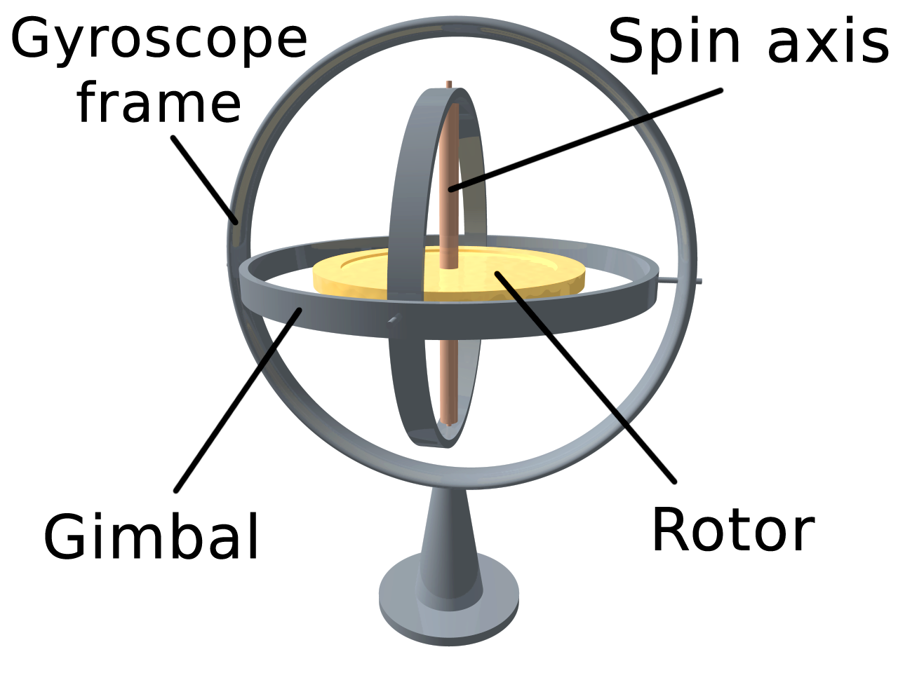
A gyroscope (from Ancient Greek ╬│ß┐”Žü╬┐Žé ''g┼Ęros'', "round" and Žā╬║╬┐ŽĆ╬ŁŽē ''skop├®┼Ź'', "to look") is a device used for measuring or maintaining orientation and angular velocity. It is a spinning wheel or disc in which the axis of rotation (spin axis) is free to assume any orientation by itself. When rotating, the orientation of this axis is unaffected by tilting or rotation of the mounting, according to the conservation of angular momentum. Gyroscopes based on other operating principles also exist, such as the microchip-packaged MEMS gyroscopes found in electronic devices (sometimes called gyrometers), solid-state ring lasers, fibre optic gyroscopes, and the extremely sensitive quantum gyroscope. Applications of gyroscopes include inertial navigation systems, such as in the Hubble Space Telescope, or inside the steel hull of a submerged submarine. Due to their precision, gyroscopes are also used in gyrotheodolites to maintain direction in tunnel mining. Gyroscopes ca ... [...More Info...] [...Related Items...] OR: [Wikipedia] [Google] [Baidu] |
Kirkenes
Kirkenes (; ; Skolt Sami: ''Ū©e├órkknjargg;'' fi, Kirkkoniemi; ; russian: ąÜąĖčĆą║ąĄąĮąĄčü) is a List of towns and cities in Norway, town in S├Ėr-Varanger Municipality in Troms og Finnmark county, in the far northeastern part of Norway. The town lies on a peninsula along the B├Ėkfjorden, an arm of the large Varangerfjorden. The main church for Kirkenes is Kirkenes Church, located in the Haganes, Finnmark, Haganes area of the town. Kirkenes is located just a few kilometres from the Norway-Russia border. The town has a population (2018) of 3,529, which gives the town a population density of . When the neighbouring suburban villages of Hesseng, Sandnes, Finnmark, Sandnes, and Bj├Ėrnevatn are all included with Kirkenes, the urban area reaches a total population of almost 8,000 people. Although Kirkenes is the Norwegian town closest to the Russian border, Vard├Ė (town), Vard├Ė to its north is located further east in Norway. History The area around Kirkenes was a common NorwegianŌĆ ... [...More Info...] [...Related Items...] OR: [Wikipedia] [Google] [Baidu] |


.jpeg)
