|
Cockburnspath
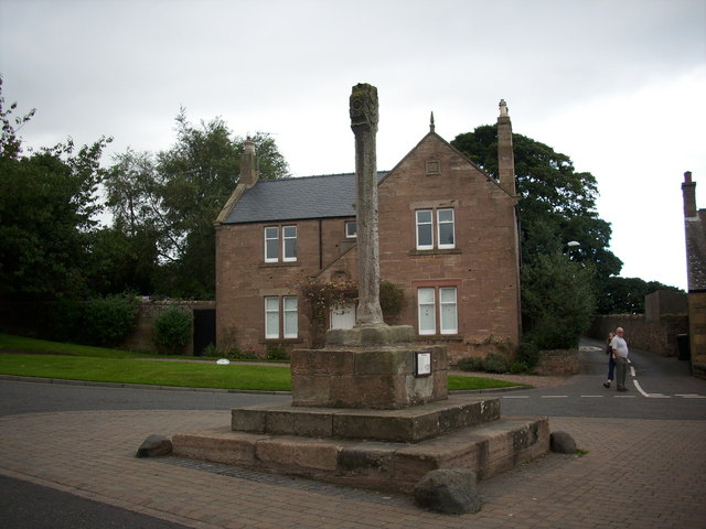
Cockburnspath ( ; sco, Co’path) is a village in the Scottish Borders area of Scotland. It lies near the North Sea coast between Berwick-upon-Tweed and Edinburgh. It is at the eastern extremity of the Southern Upland Way a long-distance footpath from the west to east coast of Scotland. It is also the termini of the Sir Walter Scott Way and the Berwickshire Coastal Path. At the nearby village of Cove, there is a small fishing harbour. History The area has many archeological remains which indicate it has been lived in and fought over since the Bronze Age. It lies close to the old invasion route from England into Scotland. Cockburnspath was originally known as " Colbrand's Path", after a folkloric giant. Sir Adam de Hepburn (d. before 1371), in the reign of David II, had a charter of the lands of Traprain, and Southalls and Northalls (united as Hailes) in Haddingtonshire, as well as the lands of Mersingtoun, Cockburnspath, and Rollanstoun in Berwickshire. The lands of Cockbu ... [...More Info...] [...Related Items...] OR: [Wikipedia] [Google] [Baidu] |
Cove, Scottish Borders
Cove is a village in the Scottish Borders area of Scotland, northwest of the Scotland/England border. It is about southeast of Edinburgh and from Dunbar. Cove is close to Cockburnspath, Dunglass, Innerwick, Oldhamstocks, Bilsdean, and, further afield, Dunbar and Eyemouth. The climate is typical for Scotland, with cold, wet winters and variable summer weather, with days of rain and days of temperatures over . The nearest railway station is Dunbar, which is on the main East Coast line from London Kings Cross to Edinburgh. There are regular trains both from Dunbar to Edinburgh and southwards to Berwick-upon-Tweed. The nearest bus station is in Cockburnspath which takes passengers north to Edinburgh terminating at St Andrews Square, and southwards, terminating in Berwick. The rocks that form the approach to the harbour are limestones and sandstones of Carboniferous age. They dip sharply to the N/NW due to the downthrust of the Cove fault about southeast. Beyond the fault, older ... [...More Info...] [...Related Items...] OR: [Wikipedia] [Google] [Baidu] |
Southern Upland Way
The Southern Upland Way is a coast-to-coast long-distance footpath in southern Scotland. The route links Portpatrick in the west and Cockburnspath in the east via the hills of the Southern Uplands. The Way is designated as one of Scotland's Great Trails by NatureScot and is the longest of the 29 Great Trails. The Southern Upland Way meets with seven of the other Great Trails: the Annandale Way, the Berwickshire Coastal Path, the Borders Abbeys Way, the Cross Borders Drove Road, the Mull of Galloway Trail, the Romans and Reivers Route and St Cuthbert's Way. The path is maintained by the local authorities of the two main council areas through which it passes: Dumfries and Galloway Council and Scottish Borders Council; a short section in the Lowther Hills lies in South Lanarkshire.Ordnance Survey ''Landranger'' 1:50000 map. Sheet 78 (Nithsdale & Annandale). It is primarily intended for walkers, but many parts are suitable for mountain bikers; some sections are also suitable for ... [...More Info...] [...Related Items...] OR: [Wikipedia] [Google] [Baidu] |
Berwickshire Coastal Path
The Berwickshire Coastal Path is a walking route some long. It follows the eastern coastline of Scotland from Cockburnspath in the Scottish Borders to Berwick upon Tweed, just over the border in England. At Cockburnspath the path links with the Southern Upland Way and the John Muir Way. The coastline traversed by the path is nationally and internationally important for seabirds, coastal flora and marine life: much of the coastline is protected as a Special Protection Area, and there is a national nature reserve at St Abbs Head which is owned by the National Trust for Scotland. Strong walkers can walk the route in two days, although the walk can be split into shorter sections to allow more time to explore the towns and villages along the way. The path was developed by Scottish Borders Council, and is now designated as one of Scotland's Great Trails by NatureScot. The route is waymarked, and there are four memorial statues at Eyemouth, Burnmouth, St Abbs and Cove to commemora ... [...More Info...] [...Related Items...] OR: [Wikipedia] [Google] [Baidu] |
Berwickshire
Berwickshire ( gd, Siorrachd Bhearaig) is a historic county, registration county and lieutenancy area in south-eastern Scotland, on the English border. Berwickshire County Council existed from 1890 until 1975, when the area became part of the Borders region, with most of the historic county becoming part of the lower-tier Berwickshire district. Berwickshire district was abolished in 1996, when all the districts in the Borders region merged to become the Scottish Borders council area. The county takes its name from Berwick-upon-Tweed, its original county town, which was part of Scotland at the time of the county's formation in the twelfth century, but became part of England in 1482 after several centuries of swapping back and forth between the two kingdoms. After the loss of Berwick, Duns and Greenlaw both served as county town at different periods. The low-lying part of Berwickshire between the Tweed and the Lammermuirs is known as "the Merse", from an old Scots word for a ... [...More Info...] [...Related Items...] OR: [Wikipedia] [Google] [Baidu] |
Haddingtonshire
East Lothian (; sco, East Lowden; gd, Lodainn an Ear) is one of the 32 council areas of Scotland, as well as a historic county, registration county and lieutenancy area. The county was called Haddingtonshire until 1921. In 1975, the historic county was incorporated for local government purposes into Lothian Region as East Lothian District, with some slight alterations of its boundaries. The Local Government etc. (Scotland) Act 1994 later created East Lothian as one of 32 modern council areas. East Lothian lies south of the Firth of Forth in the eastern central Lowlands of Scotland. It borders Edinburgh to the west, Midlothian to the south-west and the Scottish Borders to the south. Its administrative centre and former county town is Haddington while the largest town is Musselburgh. Haddingtonshire has ancient origins and is named in a charter of 1139 as ''Hadintunschira'' and in another of 1141 as ''Hadintunshire''. Three of the county's towns were designated as royal bur ... [...More Info...] [...Related Items...] OR: [Wikipedia] [Google] [Baidu] |
Sir Walter Scott Way
The Sir Walter Scott Way is a long-distance footpath in the Scottish Borders. The route broadly follows the waymarked Southern Upland Way, except for in a few sections. It commemorates Sir Walter Scott, one of Scotland's most renowned writers, who had many connections with the area. The 'Sir Walter Scott Way' runs from Moffat in Dumfries and Galloway to Cockburnspath and it is divided into six sections. It passes through Ettrick Head, St. Mary's Loch, Tibbie Shiels, Traquair, Selkirk, Galashiels, Yair, Melrose, Lauder, Longformacus, Watch Water Reservoir, and Abbey St Bathans. See also * St. Cuthbert's Way *Borders Abbeys Way *Long-distance footpaths in the United Kingdom There are hundreds of long-distance footpaths in the United Kingdom designated in publications from public authorities, guidebooks and OS maps. They are mainly used for hiking and walking, but some may also be used, in whole or in part, for moun ... References External linksGazetteer for Scotland: Si ... [...More Info...] [...Related Items...] OR: [Wikipedia] [Google] [Baidu] |
Scottish Borders
The Scottish Borders ( sco, the Mairches, 'the Marches'; gd, Crìochan na h-Alba) is one of 32 council areas of Scotland. It borders the City of Edinburgh, Dumfries and Galloway, East Lothian, Midlothian, South Lanarkshire, West Lothian and, to the south-west, south and east, the English counties of Cumbria and Northumberland. The administrative centre of the area is Newtown St Boswells. The term Scottish Borders, or normally just "the Borders", is also used to designate the areas of southern Scotland and northern England that bound the Anglo-Scottish border. Geography The Scottish Borders are in the eastern part of the Southern Uplands. The region is hilly and largely rural, with the River Tweed flowing west to east through it. The highest hill in the region is Broad Law in the Manor Hills. In the east of the region, the area that borders the River Tweed is flat and is known as 'The Merse'. The Tweed and its tributaries drain the entire region with the river flowi ... [...More Info...] [...Related Items...] OR: [Wikipedia] [Google] [Baidu] |
Dowry
A dowry is a payment, such as property or money, paid by the bride's family to the groom or his family at the time of marriage. Dowry contrasts with the related concepts of bride price and dower. While bride price or bride service is a payment by the Bridegroom, groom, or his family, to the bride, or her family, dowry is the wealth transferred from the bride, or her family, to the groom, or his family. Similarly, dower is the property settled on the bride herself, by the groom at the time of marriage, and which remains under her ownership and control. Dowry is an ancient custom that is already mentioned in some of the earliest writings, and its existence may well predate records of it. Dowries continue to be expected and demanded as a condition to accept a marriage proposal in some parts of the world, mainly in parts of Asia, The custom of dowry is most common in cultures that are strongly patrilineal and that expect women to reside with or near their husband's family (patriloca ... [...More Info...] [...Related Items...] OR: [Wikipedia] [Google] [Baidu] |
James IV Of Scotland
James IV (17 March 1473 – 9 September 1513) was King of Scotland from 11 June 1488 until his death at the Battle of Flodden in 1513. He inherited the throne at the age of fifteen on the death of his father, James III, at the Battle of Sauchieburn, following a rebellion in which the younger James was the figurehead of the rebels. James IV is generally regarded as the most successful of the Stewart monarchs. He was responsible for a major expansion of the Scottish royal navy, which included the founding of two royal dockyards and the acquisition or construction of 38 ships, including the ''Michael'', the largest warship of its time.T. Christopher Smout, ''Scotland and the Sea'' (Edinburgh: Rowman and Littlefield, 1992), , p. 45. James was a patron of the arts and took an active interest in the law, literature and science, even personally experimenting in dentistry and bloodletting. With his patronage the printing press came to Scotland, and the Royal College of Surgeons of Ed ... [...More Info...] [...Related Items...] OR: [Wikipedia] [Google] [Baidu] |
United Kingdom Census 2001
A nationwide census, known as Census 2001, was conducted in the United Kingdom on Sunday, 29 April 2001. This was the 20th UK census and recorded a resident population of 58,789,194. The 2001 UK census was organised by the Office for National Statistics (ONS) in England and Wales, the General Register Office for Scotland (GROS) and the Northern Ireland Statistics and Research Agency (NISRA). Detailed results by region, council area, ward and output area are available from their respective websites. Organisation Similar to previous UK censuses, the 2001 census was organised by the three statistical agencies, ONS, GROS, and NISRA, and coordinated at the national level by the Office for National Statistics. The Orders in Council to conduct the census, specifying the people and information to be included in the census, were made under the authority of the Census Act 1920 in Great Britain, and the Census Act (Northern Ireland) 1969 in Northern Ireland. In England and Wales these re ... [...More Info...] [...Related Items...] OR: [Wikipedia] [Google] [Baidu] |
Margaret Tudor
Margaret Tudor (28 November 1489 – 18 October 1541) was Queen of Scotland from 1503 until 1513 by marriage to King James IV. She then served as regent of Scotland during her son's minority, and successfully fought to extend her regency. Margaret was the eldest daughter and second child of King Henry VII of England and Elizabeth of York, and the elder sister of King Henry VIII of England. Margaret married James IV at the age of 13, in accordance with the Treaty of Perpetual Peace between England and Scotland. Together, they had six children, though only one of them reached adulthood. Margaret's marriage to James IV linked the royal houses of England and Scotland, which a century later resulted in the Union of the Crowns. Following the death of James IV at the Battle of Flodden in 1513, Margaret, as queen dowager, was appointed as regent for their son, King James V. A pro-French party took shape among the nobility, urging that she should be replaced by John, Duke of Albany, t ... [...More Info...] [...Related Items...] OR: [Wikipedia] [Google] [Baidu] |


