|
Chunian
Chunian ( ur, ), is a historic city and the capital of Chunian Tehsil of Punjab, Pakistan. It is located at 30° 58' N 73° 51' E and at an elevation of 177 metres (583 feet), and lies about 70 km south of Lahore the Punjab capital. It is the headquarters of a ''tehsil'' or revenue sub-division of the same name in Kasur District. Before 1976 this city is the part or tehsil of Lahore District. The city is administratively subdivided into two union councils. Chunian city (1998 census pop. 47,600) is located on the Pattoki- |
Chunian Tehsil
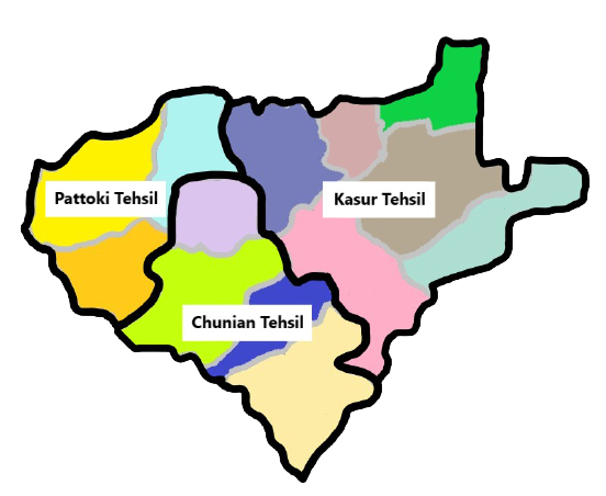
Chunian ( ur, ), is an administrative subdivision (tehsil) of Kasur District in the Punjab province of Pakistan.Tehsils & Unions in the District of Kasur - Government of Pakistan The city of is the headquarters of the tehsil. Administration The tehsil of Chunian is administratively subdivided into 27 Union Councils, these are: * * |
Kasur District
Kasur District ( Punjabi and ur, , translit=Zilā Qasūr), is a district located in Lahore Division of Punjab, Pakistan. It came into existence on 1 July 1976. Prior to its creation, it was a tehsil of the Lahore District. The district capital is Kasur city, the birth city of the Sufi poet Bulleh Shah, who is well known in that region as well as in the whole of Pakistan. The total area of the district is 4,796 square kilometres. History In ancient time, Kasur was known for its education and fish. The history of Kasur is more than 1,000 years. Kasur region was agricultural region with forests during the Indus Valley civilization. The Vedic period is characterized by Indo-Aryan culture that migrated from Central Asia and settled in Punjab region. The Kambojas, Daradas, Kaikayas, Pauravas, Yaudheyas, Malavas and Kurus migrated, settled and ruled ancient Punjab region. After overrunning the Achaemenid Empire in 331 BCE, Alexander marched into present-day Punjab region with an a ... [...More Info...] [...Related Items...] OR: [Wikipedia] [Google] [Baidu] |
Changa Manga
The Changa Manga (Urdu, Punjabi: ) is a planted forest which includes a wildlife preserve, in the Kasur and Lahore districts of Punjab, Pakistan. It is located approximately 80 kilometers south-west of Lahore. It was once the largest man-made forest in the world but has undergone illegal deforestation at a massive scale in recent times. Changa Manga is known more widely as "one of the oldest hand-planted forests in the world", and hosts a wide variety of flora and fauna. The forest is home to 14 species of mammals, 50 species of birds, six species of reptiles, two species of amphibians and 27 species of insects. Thus, other than producing timber for the local industry, the forest also serves as an important wildlife reserve. Named after two brother dacoits, the Changa Manga forest was originally planted in 1866 by British foresters. Its trees were harvested to gather fuel and resources for the engines employed in the North-Western railway networks. Onomatology of name The ... [...More Info...] [...Related Items...] OR: [Wikipedia] [Google] [Baidu] |
Kasur
Kasur (Urdu and pa, ; also Romanization of Urdu, romanized as Qasūr; from pluralized Arabic word ''Qasr'' meaning "palaces" or "forts") is a city to south of Lahore, in the Pakistani province of Punjab, Pakistan, Punjab. The city serves as the headquarters of Kasur District. Kasur is the List of most populous cities in Pakistan, 24th largest city of Pakistan by population. It is also known for being the burial place of the 17th-century Sufi poetry, Sufi-poet Bulleh Shah.the most famous shrine of Hazrat syed lal habiab zedi grand son of imam hussain a.s . It is farther west of the border with neighboring India, and bordered to Lahore District, Lahore, Sheikhupura District, Sheikhupura, and the Okara District of Punjab Province. The city is an aggregation of 26 fortified hamlets overlooking the alluvial valleys of the Beas and Sutlej rivers. Etymology Kasur derives its name from the Arabic and Persian language, Persian word ''qasur'' (), meaning "palaces," or "forts." Hindu tra ... [...More Info...] [...Related Items...] OR: [Wikipedia] [Google] [Baidu] |
Gehlan Hithar
Gehlan Hithar is a town and Union Council of Kasur District, situated some 65 miles south west of Lahore, Punjab, Pakistan. It is located at 30°52'0N 74°1'60E with an altitude of 174 metres (574 feet) Fallingrain.com. Retrieved on 2012-01-14. and lies on the main Kasur-Okara road. It lies in the boundaries of National Assembly constituency NA 140 and Provincial constituency PP 180. Ex foreign minister was MNA from this area. The livelihood of the people is based on agriculture with a big share of flower growing beside wheat, rice and vegetables including potatoes and maize. The flower market recently ... [...More Info...] [...Related Items...] OR: [Wikipedia] [Google] [Baidu] |

.jpg)