|
Changxing
() is a county of the prefecture-level city of Huzhou, in the northwest of Zhejiang province, China. Situated on the southwest shore of Lake Tai, it borders the provinces of Jiangsu to the north and Anhui to the west. It has a total area of and a population of 620,000 inhabitants. Changxing, established in the third year of Taikang's reign ( emperor Wu of Jin) (282 AD) during the Jin Dynasty, has an extensive history of over 1,700 years. It has rich resources, a long cultural heritage, and cherishes its fame as ÔÇťthe realm of fish and riceÔÇŁ, ÔÇťthe home of silkÔÇŁ, ÔÇťthe land of cultureÔÇŁ, and ÔÇťthe distinguished county in the southeast ChinaÔÇŁ. The Changhsingian Age of the Permian Period of geological time is named after Changxing. The stage was named for the Changhsing Limestone. Since 2004, Changxing has had a Twin City (County) relationship with Kalmar County in Sweden. Administrative divisions Towns: * Zhicheng, Changxing (ÚŤëňčÄÚĽç), Hongqiao, Changxing (Š┤¬Š ... [...More Info...] [...Related Items...] OR: [Wikipedia] [Google] [Baidu] |
Huzhou
Huzhou (, ; Huzhounese: ''ghou┬▓ cieu┬╣'') is a prefecture-level city in northern Zhejiang province (HangzhouÔÇôJiaxingÔÇôHuzhou Plain, China). Lying south of the Lake Tai, it borders Jiaxing to the east, Hangzhou to the south, and the provinces of Anhui and Jiangsu to the west and north respectively. As of the 2020 census, its population was 3,367,579 inhabitants, of whom 1,015,937 lived in the built-up (''or metro'') area made of Wuxing District as Nanxun District is not being conurbated yet. Location Huzhou, in its general aspect, is in the center of the Yangtze River Delta Economic Area, with the city center south of the Chinese third largest freshwater lake Lake Tai. There are transportation links to the provincial capital of Hangzhou away in the south, Jiangsu and Anhui province in the west, and the metropolitan municipality of Shanghai to the northeast. Flowing quietly through the city is the Changxing-Huzhou-Shanghai Channel, it is also referred to as the "Eastern ... [...More Info...] [...Related Items...] OR: [Wikipedia] [Google] [Baidu] |
Changhsingian
In the geologic time scale, the Changhsingian or Changxingian is the latest age or uppermost stage of the Permian. It is also the upper or latest of two subdivisions of the Lopingian Epoch or Series. The Changhsingian lasted from to 251.902 million years ago (Ma). It was preceded by the Wuchiapingian and followed by the Induan. The greatest mass extinction in the Phanerozoic eon, the PermianÔÇôTriassic extinction event, occurred during this age. The extinction rate peaked about a million years before the end of this stage. Stratigraphic definitions The Changhsingian is named after Changxing () in northern Zhejiang, China. The stage was named for the Changhsing Limestone. The name was first used for a stage in 1970; 1973: ''Permian stages names'', in: : ''The Permian and Triassic systems and their mutual boundary'', Canadian Society of Petroleum Geologists Memoir 2, pp 522ÔÇô548. and was anchored in the international timescale in 1981.; 2006: ''The Global Boundary Stratotype Sect ... [...More Info...] [...Related Items...] OR: [Wikipedia] [Google] [Baidu] |
Permian
The Permian ( ) is a geologic period and stratigraphic system which spans 47 million years from the end of the Carboniferous Period million years ago (Mya), to the beginning of the Triassic Period 251.9 Mya. It is the last period of the Paleozoic Era; the following Triassic Period belongs to the Mesozoic Era. The concept of the Permian was introduced in 1841 by geologist Sir Roderick Murchison, who named it after the region of Perm in Russia. The Permian witnessed the diversification of the two groups of amniotes, the synapsids and the sauropsids ( reptiles). The world at the time was dominated by the supercontinent Pangaea, which had formed due to the collision of Euramerica and Gondwana during the Carboniferous. Pangaea was surrounded by the superocean Panthalassa. The Carboniferous rainforest collapse left behind vast regions of desert within the continental interior. Amniotes, which could better cope with these drier conditions, rose to dominance in place of their am ... [...More Info...] [...Related Items...] OR: [Wikipedia] [Google] [Baidu] |
Shuikou Township
Shuikou may refer to: *Shuikou, Meizhou, a town in Xingning City, Meizhou, Guangdong Province, China *Shuikou, Yanling, a town in Yanling County, Huzhou, Hunan Province, China * Shuikou, Gutian, a town in Gutian County, Ningde, Fujian Province, China * Shuikou, Dehua, a town in Dehua County, Quanzhou, Fujian Province, China * Shuikou, Kaiping, a town in Kaiping City, Jiangmen, Guangdong Province, China *Shuikou, Chongzuo, a town in Longzhou County, Chongzuo, Guangxi Zhuang Autonomous Region, China * Shuikou, Liping, a town in Liping County, Qiandongnan Miao and Dong Autonomous Prefecture, Guizhou, China * Shuikou, Suining, a town in Suining County, Shaoyang, Hunan Province, China * Shuikou, Binzhou, a town in Binzhou City, Xianyang, Shaanxi Province, China * Shuikou, Changxing, a township in Changxing County () is a county of the prefecture-level city of Huzhou, in the northwest of Zhejiang province, China. Situated on the southwest shore of Lake Tai, it borders the provin ... [...More Info...] [...Related Items...] OR: [Wikipedia] [Google] [Baidu] |
Postal Code Of China
Postal codes in the People's Republic of China () are postal codes used by China Post for the delivery of letters and goods within mainland China. China Post uses a six-digit all-numerical system with four tiers: the first tier, composed of the first two digits, show the province, province-equivalent municipality, or autonomous region; the second tier, composed of the third digit, shows the postal zone within the province, municipality or autonomous region; the fourth digit serves as the third tier, which shows the postal office within prefectures or prefecture-level cities; the last two digits are the fourth tier, which indicates the specific mailing area for delivery. The range 000000ÔÇô009999 was originally marked for Taiwan (The Republic of China) but is not used because it not under the control of the People's Republic of China. Mail to ROC is treated as international mail, and uses postal codes set forth by Chunghwa Post. Codes starting from 999 are the internal codes use ... [...More Info...] [...Related Items...] OR: [Wikipedia] [Google] [Baidu] |
Kalmar County
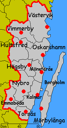
Kalmar County () is a county or '' l├Ąn'' in southern Sweden. It borders the counties of Kronoberg, J├Ânk├Âping, Blekinge and ├ľsterg├Âtland. To the east in the Baltic Sea is the island Gotland. The counties are mainly administrative units. Geographically Kalmar County covers the eastern part in the Sm├ąland province, and the entire island of ├ľland. Culture Much of ├ľland's present day landscape known as the Stora Alvaret has been designated as a World Heritage Site by UNESCO. This southern part of ├ľland is known for a large number of rare species; early paleolithic settlement at Alby; other prehistoric remains such as the Gettlinge Gravefield and Eketorp Fortress; and the Ottenby Nature Preserve. Administration Kalmar County was integrated with Kronoberg County until 1672. Blekinge was a part of Kalmar County between 1680 and 1683, due to the foundation of the naval base at Karlskrona. The seat of residence for the Governor or ''Landsh├Âvding'' is Kalmar. The Govern ... [...More Info...] [...Related Items...] OR: [Wikipedia] [Google] [Baidu] |


