|
Calderbrook
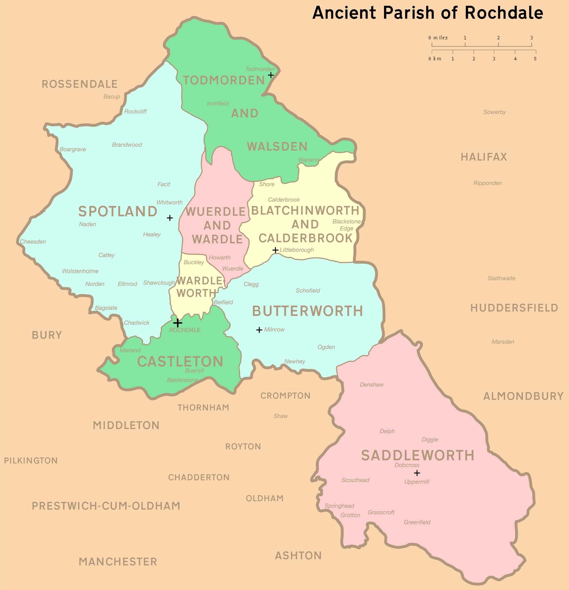
Calderbrook ( ) is a village within the Metropolitan Borough of Rochdale, in Greater Manchester, England. It was originally part of the township of ''Blatchinworth and Calderbrook'' within the ancient parish of Rochdale, becoming a separate civil parish in 1866. The civil parish was abolished in 1894, when it became part of Littleborough urban district. See also *Listed buildings in Littleborough, Greater Manchester Littleborough is a town in the Metropolitan Borough of Rochdale, Greater Manchester, England, and it is unparished. The town, its suburbs of Calderbrook and Smithy Bridge, and the surrounding countryside contain 79 listed buildings that are r ... References Villages in Greater Manchester {{GreaterManchester-geo-stub ... [...More Info...] [...Related Items...] OR: [Wikipedia] [Google] [Baidu] |
Listed Buildings In Littleborough, Greater Manchester
Littleborough is a town in the Metropolitan Borough of Rochdale, Greater Manchester, England, and it is unparished. The town, its suburbs of Calderbrook and Smithy Bridge, and the surrounding countryside contain 79 listed buildings that are recorded in the National Heritage List for England. Of these, five are listed at Grade II*, the middle grade, and the others are at Grade II, the lowest grade. The area is largely rural, and most of the listed buildings are houses and associated structures, farmhouses, and farm buildings. Following the Industrial Revolution textile mills were built, some of which remain and are listed. The Rochdale Canal passes through the area and bridges and locks associated with it are listed. Also passing through the area was the Manchester and Leeds Railway, and structures associated with it are listed. The other listed buildings include churches, public houses, a former toll house, a bandstand, a drinking fountain A drinking fount ... [...More Info...] [...Related Items...] OR: [Wikipedia] [Google] [Baidu] |
Rochdale (ancient Parish)
Rochdale was an ecclesiastical parish of early-medieval origin in northern England, administered from the Church of St Chad, Rochdale. At its zenith, it occupied of land amongst the South Pennines, and straddled the historic county boundary between Lancashire and the West Riding of Yorkshire. To the north and north-west was the parish of Whalley; to the southwest was the parish of Bury; to the south was Middleton and Prestwich-cum-Oldham. Anciently a dependency of Whalley Abbey, the parish of Rochdale is believed to be of Anglo-Saxon origin, as evidenced by historical documentation, toponymy and its dedication to Chad of Mercia. Urbanisation, population shifts, and local government reforms all contributed towards the gradual alteration and ultimate dissolution of the historic parish boundaries; the social welfare functions of the parish were broadly superseded by the English Poor Laws and new units of local governance, such as the County Borough of Rochdale and the Milnrow Ur ... [...More Info...] [...Related Items...] OR: [Wikipedia] [Google] [Baidu] |
Littleborough, Greater Manchester
Littleborough ( ) is a town in the Metropolitan Borough of Rochdale, Greater Manchester, England, in the upper Roch Valley by the foothills of the South Pennines, northeast of Rochdale and northeast of Manchester; Milnrow and the M62 motorway are to the south, and the rural uplands of Blackstone Edge to the east. In 2001, Littleborough, and its suburbs of Calderbrook, Shore and Smithy Bridge,. had a population of 13,807. Within the boundaries of the historic county of Lancashire, Littleborough and its surroundings have provided evidence of Neolithic, Celtic, Roman and Anglo-Saxon activity in the area. During the Middle Ages, Littleborough was a hamlet in the manor of Hundersfield, parish of Rochdale and hundred of Salford.. It was focussed upon the junction of two ancient routes over the Pennines — one of which may have been a Roman road — that joined to cross the River Roch. By 1472, Littleborough consisted of a chapel, a cluster of cottages, and an inn, and its inha ... [...More Info...] [...Related Items...] OR: [Wikipedia] [Google] [Baidu] |
Rochdale Canal
The Rochdale Canal is in Northern England, between Manchester and Sowerby Bridge, part of the connected system of the canals of Great Britain. Its name refers to the town of Rochdale through which it passes. The Rochdale is a broad canal because its locks are wide enough to allow vessels of width. The canal runs for across the Pennines from the Bridgewater Canal at Castlefield Basin in Manchester to join the Calder and Hebble Navigation at Sowerby Bridge in West Yorkshire. As built, the canal had 92 locks. Whilst the traditional lock numbering has been retained on all restored locks, and on the relocated locks, the canal now has 91. Locks 3 and 4 have been replaced with a single deep lock, Tuel Lane Lock, which is numbered 3/4. History The Rochdale Canal was conceived in 1776, when a group of 48 men from Rochdale raised £237 and commissioned James Brindley to conduct a survey of possible routes between Sowerby Bridge and Manchester. Brindley proposed a route similar to ... [...More Info...] [...Related Items...] OR: [Wikipedia] [Google] [Baidu] |
Metropolitan Borough Of Rochdale
The Metropolitan Borough of Rochdale is a metropolitan borough of Greater Manchester in North West England. It is named after its largest town, Rochdale, The borough covers other outlying towns and villages with a population of 206,500 at the 2011 census. It is the ninth-largest district by population in Greater Manchester. History The borough was formed in 1974 as part of the provisions of the Local Government Act 1972 and is an amalgamation of six former local government districts. It was originally proposed that the borough include the neighbouring town of Bury and disclude Middleton; Bury however went on to form the administrative centre for the adjacent Metropolitan Borough of Bury. The borough was formed by a merger of the former county borough of Rochdale and from the administrative county of Lancashire, the municipal boroughs of Heywood and Middleton, along with the urban districts of Littleborough, Milnrow and Wardle.The borough lies mostly within the historic count ... [...More Info...] [...Related Items...] OR: [Wikipedia] [Google] [Baidu] |
Greater Manchester
Greater Manchester is a metropolitan county and combined authority, combined authority area in North West England, with a population of 2.8 million; comprising ten metropolitan boroughs: City of Manchester, Manchester, City of Salford, Salford, Metropolitan Borough of Bolton, Bolton, Metropolitan Borough of Bury, Bury, Metropolitan Borough of Oldham, Oldham, Metropolitan Borough of Rochdale, Rochdale, Metropolitan Borough of Stockport, Stockport, Tameside, Trafford and Metropolitan Borough of Wigan, Wigan. The county was created on 1 April 1974, as a result of the Local Government Act 1972, and designated a functional Manchester City Region, city region on 1 April 2011. Greater Manchester is formed of parts of the Historic counties of England, historic counties of Cheshire, Lancashire and the West Riding of Yorkshire. Greater Manchester spans , which roughly covers the territory of the Greater Manchester Built-up Area, the List of urban areas in the United Kingdom, second most ... [...More Info...] [...Related Items...] OR: [Wikipedia] [Google] [Baidu] |
Rochdale (UK Parliament Constituency)
Rochdale is a seat represented in the House of Commons of the UK Parliament. It has elected one Member of Parliament (MP) since its 1832 creation. The constituency is represented by Tony Lloyd of the Labour Party. He was first elected MP for this seat in 2017; previously, he had been the MP for Stretford and then Manchester Central from 1983 until his resignation from Parliament in 2012. Boundaries As there were no township boundaries in 1832, the original constituency was defined as a circular area in a radius of three-quarters of a mile from the old market place. In 1868 the boundary was extended to include Wardleworth, Spotland, Wuerdle, Belfield, Newbold, Buersill, and Marland. 1918–1950: The County Borough of Rochdale 1950–1983: As prior but with redrawn boundaries 1983–1997: The Borough of Rochdale wards of Balderstone, Brimrod and Deeplish, Castleton, Central and Falinge, Healey, Newbold, Norden and Bamford, Smallbridge and Wardleworth, and Spotland 1997–20 ... [...More Info...] [...Related Items...] OR: [Wikipedia] [Google] [Baidu] |
Township (England)
In England, a township (Latin: ''villa'') is a local division or district of a large parish containing a village or small town usually having its own church. A township may or may not be coterminous with a chapelry, manor, or any other minor area of local administration. The township is distinguished from the following: *Vill: traditionally, among legal historians, a ''vill'' referred to the tract of land of a rural community, whereas ''township'' was used when referring to the tax and legal administration of that community. *Chapelry: the 'parish' of a chapel (a church without full parochial functions). *Tithing: the basic unit of the medieval Frankpledge system. 'Township' is, however, sometimes used loosely for any of the above. History In many areas of England, the basic unit of civil administration was the parish, generally identical with the ecclesiastical parish. However, in some cases, particularly in Northern England, there was a lesser unit called a township, being a ... [...More Info...] [...Related Items...] OR: [Wikipedia] [Google] [Baidu] |
Civil Parishes In England
In England, a civil parish is a type of Parish (administrative division), administrative parish used for Local government in England, local government. It is a territorial designation which is the lowest tier of local government below districts of England, districts and metropolitan and non-metropolitan counties of England, counties, or their combined form, the Unitary authorities of England, unitary authority. Civil parishes can trace their origin to the ancient system of Parish (Church of England), ecclesiastical parishes, which historically played a role in both secular and religious administration. Civil and religious parishes were formally differentiated in the 19th century and are now entirely separate. Civil parishes in their modern form came into being through the Local Government Act 1894, which established elected Parish councils in England, parish councils to take on the secular functions of the vestry, parish vestry. A civil parish can range in size from a sparsely ... [...More Info...] [...Related Items...] OR: [Wikipedia] [Google] [Baidu] |
Urban District (Great Britain And Ireland)
In England and Wales, Northern Ireland, and the Republic of Ireland, an urban district was a type of local government district that covered an urbanised area. Urban districts had an elected urban district council (UDC), which shared local government responsibilities with a county council. England and Wales In England and Wales, urban districts and rural districts were created in 1894 (by the Local Government Act 1894) as subdivisions of administrative counties. They replaced the earlier system of urban and rural sanitary districts (based on poor law unions) the functions of which were taken over by the district councils. The district councils also had wider powers over local matters such as parks, cemeteries and local planning. An urban district usually contained a single parish, while a rural district might contain many. Urban districts were considered to have more problems with public health than rural areas, and so urban district councils had more funding and greater power ... [...More Info...] [...Related Items...] OR: [Wikipedia] [Google] [Baidu] |


