|
Cakung River
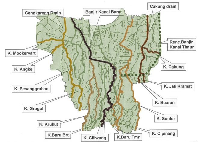
Cakung River is a river in the Bekasi, West Java and eastern part of the Special Capital Region of Jakarta, Indonesia. The lower portions of the original river have been channelized and directed into the eastern flood canal, " Banjir Kanal Timur", which continues to flow to the Java Sea in the district of Marunda, Cilincing, North Jakarta. The river regularly causes flooding in the city of Bekasi and Jakarta.Kali Cakung Lama Jadi Penyebab Tiga Kecamatan di Jakarta Utara Ini Tergenang Tribun News. 1 Mar 2017. History Cakung and the other two nearby rivers: Jatikramat and[...More Info...] [...Related Items...] OR: [Wikipedia] [Google] [Baidu] |
Indonesia
Indonesia, officially the Republic of Indonesia, is a country in Southeast Asia and Oceania between the Indian and Pacific oceans. It consists of over 17,000 islands, including Sumatra, Java, Sulawesi, and parts of Borneo and New Guinea. Indonesia is the world's largest archipelagic state and the 14th-largest country by area, at . With over 275 million people, Indonesia is the world's fourth-most populous country and the most populous Muslim-majority country. Java, the world's most populous island, is home to more than half of the country's population. Indonesia is a presidential republic with an elected legislature. It has 38 provinces, of which nine have special status. The country's capital, Jakarta, is the world's second-most populous urban area. Indonesia shares land borders with Papua New Guinea, East Timor, and the eastern part of Malaysia, as well as maritime borders with Singapore, Vietnam, Thailand, the Philippines, Australia, Palau, and India ... [...More Info...] [...Related Items...] OR: [Wikipedia] [Google] [Baidu] |
Jakarta
Jakarta (; , bew, Jakarte), officially the Special Capital Region of Jakarta ( id, Daerah Khusus Ibukota Jakarta) is the capital and largest city of Indonesia. Lying on the northwest coast of Java, the world's most populous island, Jakarta is the largest city in Southeast Asia and serves as the diplomatic capital of ASEAN. The city is the economic, cultural, and political centre of Indonesia. It possesses a province-level status and has a population of 10,609,681 as of mid 2021.Badan Pusat Statistik, Jakarta, 2022. Although Jakarta extends over only , and thus has the smallest area of any Indonesian province, its metropolitan area covers , which includes the satellite cities Bogor, Depok, Tangerang, South Tangerang, and Bekasi, and has an estimated population of 35 million , making it the largest urban area in Indonesia and the second-largest in the world (after Tokyo). Jakarta ranks first among the Indonesian provinces in human development index. Jakarta's busin ... [...More Info...] [...Related Items...] OR: [Wikipedia] [Google] [Baidu] |
Bekasi
Bekasi (, su, ) is a city in West Java, Indonesia, located on the eastern border of Jakarta.the city of planet Bekasi is his nickname.It serves as a commuter city within the Jakarta metropolitan area. According to the 2020 Census by Statistics Indonesia (BPS), Bekasi had 2,543,676 inhabitants. The official estimate for mid 2021 was 2,564,940. It lies within the largest metropolitan area in Indonesia (''Jabodetabek''). The city is bordered by Bekasi Regency to the north and the east, Bogor Regency and Depok to the south, and East Jakarta to the west. Bekasi is one of the oldest cities in Indonesia, and has a history of being the capital city of the Kingdom of Tarumanagara. At that time, the name of Bekasi was Dayeuh Sundasembawa or Jayagiri. The earliest evidence of its existence dates from the fifth century according to the Tugu inscription, which describes the name of two rivers that run through the city, i.e. Candrabhaga and Gomati and one of those rivers, i.e. Candrabhaga i ... [...More Info...] [...Related Items...] OR: [Wikipedia] [Google] [Baidu] |
West Java
West Java ( id, Jawa Barat, su, ᮏᮝ ᮊᮥᮜᮧᮔ᮪, romanized ''Jawa Kulon'') is a province of Indonesia on the western part of the island of Java, with its provincial capital in Bandung. West Java is bordered by the province of Banten and the country's capital region of Jakarta to the west, the Java Sea to the north, the province of Central Java to the east and the Indian Ocean to the south. With Banten, this province is the native homeland of the Sundanese people, the second-largest ethnic group in Indonesia. West Java was one of the first eight provinces of Indonesia formed following the country's independence proclamation and was later legally re-established on 14 July 1950. In 1966, the city of Jakarta was split off from West Java as a 'special capital region' (), with a status equivalent to that of a province, while in 2000 the western parts of the province were in turn split away to form a separate Banten province. Even following these split-offs, West Java is ... [...More Info...] [...Related Items...] OR: [Wikipedia] [Google] [Baidu] |
Banjir Kanal Timur
The Jakarta Flood Canal ( id, Kanal Banjir Jakarta) refers to two canals that divert floods from rivers around Jakarta instead of going through the city. This first flood control channel was designed by Hendrik van Breen, an engineer working for the Dutch East Indian ''Department van Burgelijke Openbare Werken'' (BOW—lit. Department of Public Civil Works, currently the Ministry of Public Works and People's Housing), after a big flood hit the city on 13 February 1918. West and East Flood Canal With help of ''Netherlands Engineering Consultants'', the "''Master Plan for Drainage and Flood Control of Jakarta''" was published in December 1973. According to this plan, flood control of Jakarta would revolve around two canals encircling the city. The canals divert the water flowing from the south around the city and into the sea. These canals are known as West Flood Canal (Indonesian: ''Banjir Kanal Barat'') and East Flood Canal (Indonesian: ''Banjir Kanal Timur''). Other measures to ... [...More Info...] [...Related Items...] OR: [Wikipedia] [Google] [Baidu] |
East Jakarta
) in Taman Mini Indonesia Indah (TMII), Jatinegara railway station and Museum of Transportation at Taman Mini Indonesia Indah. , image_seal = Lambang Kota Jakarta Timur.png , motto = , image_map = Jakarta_timur.png , map_alt = , map_caption = , coordinates = , coordinates_footnotes = , subdivision_type = Country , subdivision_name = , subdivision_type1 = Province , subdivision_type2 = , subdivision_name1 = Jakarta , subdivision_name2 = , government_footnotes = , leader_title = Mayor , leader_name = Muhammad Anwar , leader_title1 = Vice Mayor , leader_name1 = Hendra Hidayat , area_magnitude = , area_total_km2 ... [...More Info...] [...Related Items...] OR: [Wikipedia] [Google] [Baidu] |
Special Capital Region Of Jakarta
Jakarta (; , bew, Jakarte), officially the Special Capital Region of Jakarta ( id, Daerah Khusus Ibukota Jakarta) is the capital and largest city of Indonesia. Lying on the northwest coast of Java, the world's most populous island, Jakarta is the largest city in Southeast Asia and serves as the diplomatic capital of ASEAN. The city is the economic, cultural, and political centre of Indonesia. It possesses a province-level status and has a population of 10,609,681 as of mid 2021.Badan Pusat Statistik, Jakarta, 2022. Although Jakarta extends over only , and thus has the smallest area of any Indonesian province, its metropolitan area covers , which includes the satellite cities Bogor, Depok, Tangerang, South Tangerang, and Bekasi, and has an estimated population of 35 million , making it the largest urban area in Indonesia and the second-largest in the world (after Tokyo). Jakarta ranks first among the Indonesian provinces in human development index. Jakarta's business ... [...More Info...] [...Related Items...] OR: [Wikipedia] [Google] [Baidu] |
North Jakarta
North Jakarta ( id, Jakarta Utara; bew, Jakarte Belilir) is one of the five administrative cities (''kota administrasi'') which form Special Capital Region of Jakarta, Indonesia. North Jakarta is not self-governed and does not have a city council, hence it is not classified as a proper municipality. It contains the entire coastal area within the Jakarta Special District. In North Jakarta, an area at the estuary of Ciliwung river was the main port for the kingdom of Tarumanegara, which later grew to become Jakarta. Many historic sites and artefacts of Jakarta can be found in North Jakarta. Both ports of Tanjung Priok and historic Sunda Kelapa are located in the city. The city, which covers an area of 139.99 km2, had 1,645,659 inhabitants at the 2010 census and 1,778,981 at the 2020 census. It has its administrative centre in Tanjung Priok. North Jakarta contains some of Jakarta's original natural mangrove forests. As the city has developed, some of this mangrove forest was co ... [...More Info...] [...Related Items...] OR: [Wikipedia] [Google] [Baidu] |
Jatikramat River
The Jatikramat River (Kali Jatikramat or Kali Jati Kramat) is a river in Bekasi, West Java, and the eastern part of the Special Capital Region of Jakarta, Indonesia. The lower portions of the original river have been channelized and directed into the eastern flood canal, " Banjir Kanal Timur", which continues to flow to the Java Sea in the district of Marunda, Cilincing, North Jakarta. The river regularly causes flooding in the city of Bekasi and Jakarta.Kali Buaran Meluap, Permukiman di Taman Malaka Selatan Tergenang Robertus Belarminus, Kompas.com - 21 Feb 2017. History The Jatikramat and the other two nearby rivers, the |
Buaran River
The Buaran River (Kali Buaran) is a river flowing in the Bekasi, West Java and eastern part of the Special Capital Region of Jakarta, Indonesia. The lower portions of the original river have been channelized and directed into the eastern flood canal, "Banjir Kanal Timur", which continues to flow to the Java Sea in the district of Marunda, Cilincing, North Jakarta. The river regularly causes flooding in the city of BekasiJakarta, Bekasi, dan Tangerang Masih Rawan Banjir - Alsadad Rudi, Kompas.com - 21 Feb 2017. and Jakarta. [...More Info...] [...Related Items...] OR: [Wikipedia] [Google] [Baidu] |
Sunter River
The Sunter River or ''Kali Sunter'' is a river that flows in the eastern part of Jakarta, Indonesia. The river is about 37 km long and has 73,184,092 m2 of river basin. Neighborhoods along the Kali Sunter are very densely populated and prone to frequent flooding. Geography The river flows in the northwest area of Java with predominantly tropical rainforest climate (designated as ''Af'' in the Köppen–Geiger climate classification). The annual average temperature in the area is 26 °C. The warmest month is August, when the average temperature is around 28 °C, and the coldest is April, at 24 °C. The average annual rainfall is 3674 mm. The wettest month is December, with an average of 456 mm rainfall, and the driest is September, with 87 mm rainfall. Normalisation The river is one of the 13 rivers that flows through Jakarta. It is currently undergoing embankment installation and river normalization. The length of embankment is 18.35 km, ... [...More Info...] [...Related Items...] OR: [Wikipedia] [Google] [Baidu] |
Drainage
Drainage is the natural or artificial removal of a surface's water and sub-surface water from an area with excess of water. The internal drainage of most agricultural soils is good enough to prevent severe waterlogging (anaerobic conditions that harm root growth), but many soils need artificial drainage to improve production or to manage water supplies. History Early history The Indus Valley civilization had sewerage and drainage systems. All houses in the major cities of Harappa and Mohenjo-daro had access to water and drainage facilities. Waste water was directed to covered gravity sewers, which lined the major streets. 18th and 19th century The invention of hollow-pipe drainage is credited to Sir Hugh Dalrymple, who died in 1753. Current practices Geotextiles New storm water drainage systems incorporate geotextile filters that retain and prevent fine grains of soil from passing into and clogging the drain. Geotextiles are synthetic textile fabrics specially ... [...More Info...] [...Related Items...] OR: [Wikipedia] [Google] [Baidu] |


_bij_Pasar_Baru_langs_de_Postweg_TMnr_60001164.jpg)
