|
Surkhet District
Surkhet District ( ne, सुर्खेत जिल्ला, ) is a district in Karnali Province of mid-western Nepal. Surkhet is the one of the ten Districts of Nepal, districts of Karnali located about west of the national capital Kathmandu. The district's area is . It had 288,527 population in 2001 and 350,804 in 2011 which male comprised 169,461 and female 181,381. Its district headquarters, Birendranagar, is the capital of Karnali Province. It is serving as a business hub and document center for Karnali province. According to population, development, road links, landforms, climate, many peoples are migrating here. after becoming province capital developmental activities are boosted and are in peak level. all the governmental works are carried here. Birendranagar is beautiful valley surrounded by hills having moderate climate. Geography and Climate Surkhet Valley is one of the Inner Terai Valleys of Nepal. It borders, Achham District, Achham district of Sudurpashchim Provi ... [...More Info...] [...Related Items...] OR: [Wikipedia] [Google] [Baidu] |
Districts Of Nepal
Districts in Nepal are second level of administrative divisions after provinces. Districts are subdivided in municipalities and rural municipalities. There are seven provinces and 77 districts in Nepal. After the state's reconstruction of administrative divisions, Nawalparasi District and Rukum District were divided into Parasi District (officially Nawalparasi (West of Bardaghat Susta) District) and Nawalpur District (officially Nawalparasi (East of Bardaghat Susta) District), and Eastern Rukum District and Western Rukum District respectively. District official include: * Chief District Officer, an official under Ministry of Home Affairs is appointed by the government as the highest administrative officer in a district. The C.D.O is responsible for proper inspection of all the departments in a district such as health, education, security and all other government offices. * District Coordination Committee acts as an executive to the District Assembly. The DCC coordinates with ... [...More Info...] [...Related Items...] OR: [Wikipedia] [Google] [Baidu] |
Achham District
Achham ( ne, अछाम जिल्ला ) is a district located in Sudurpashchim province of Nepal. It is one of the nine districts of the province. The district, with Mangalsen as its district headquarters, covers an area of 1,692 km and has a population (2011) of 257,477. Etymology There are many cultural meaning about the naming of the district but one interesting folklore is that: History Achham was a part of Doti Kingdom during medieval era. Nepal annexed Doti in 1790 It remained part of Doti District until 1961. On 13 April 1961, Achham district carved out from Doti District and declared a separate district Geography and Climate Achham covers an area of and located at Latitude: 280°46’ North to 290°23' North and Longitude: 810°32 East to 810°35' East. 90% area of Achham is mid-hill and 10% is high-hill. The maximum elevation of the district is and minimum elevation is from the sea level. The district is surrounded by Bajura District in the North, Do ... [...More Info...] [...Related Items...] OR: [Wikipedia] [Google] [Baidu] |
Temperate Climate
In geography, the temperate climates of Earth occur in the middle latitudes (23.5° to 66.5° N/S of Equator), which span between the tropics and the polar regions of Earth. These zones generally have wider temperature ranges throughout the year and more distinct seasonal changes compared to tropical climates, where such variations are often small and usually only have precipitation changes. In temperate climates, not only do latitudinal positions influence temperature changes, but sea currents, prevailing wind direction, continentality (how large a landmass is) and altitude also shape temperate climates. The Köppen climate classification defines a climate as "temperate" C, when the mean temperature is above but below in the coldest month to account for the persistency of frost. However, other climate classifications set the minimum at . Zones and climates The north temperate zone extends from the Tropic of Cancer (approximately 23.5° north latitude) to the Arctic ... [...More Info...] [...Related Items...] OR: [Wikipedia] [Google] [Baidu] |
Subtropics
The subtropical zones or subtropics are geographical and climate zones to the north and south of the tropics. Geographically part of the temperate zones of both hemispheres, they cover the middle latitudes from to approximately 35° north and south. The horse latitudes lie within this range. Subtropical climates are often characterized by hot summers and mild winters with infrequent frost. Most subtropical climates fall into two basic types: humid subtropical (Koppen climate Cfa), where rainfall is often concentrated in the warmest months, for example Southeast China and the Southeastern United States, and dry summer or Mediterranean climate (Koppen climate Csa/Csb), where seasonal rainfall is concentrated in the cooler months, such as the Mediterranean Basin or Southern California. Subtropical climates can also occur at high elevations within the tropics, such as in the southern end of the Mexican Plateau and in Da Lat of the Vietnamese Central Highlands. The six climate cl ... [...More Info...] [...Related Items...] OR: [Wikipedia] [Google] [Baidu] |
Tropical Climate
Tropical climate is the first of the five major climate groups in the Köppen climate classification identified with the letter A. Tropical climates are defined by a monthly average temperature of 18 °C (64.4 °F) or higher in the coolest month, and feature hot temperatures all year-round. Annual precipitation is often abundant in tropical climates, and shows a seasonal rhythm but may have seasonal dryness to varying degrees. There are normally only two seasons in tropical climates, a wet (rainy / monsoon) season and a dry season. The annual temperature range in tropical climates is normally very small. Sunlight is intense in these climates. There are three basic types of tropical climates within the tropical climate group: tropical rainforest climate (Af), tropical monsoon climate (Am) and tropical wet and dry climate or tropical savannah (Aw for dry winters, and As for dry summers), which are classified and distinguished by the precipitation and the precipitation lev ... [...More Info...] [...Related Items...] OR: [Wikipedia] [Google] [Baidu] |
Geography Of Nepal
Nepal measures about along its Himalayan axis by across. It has an area of . Nepal is landlocked by China's Tibet Autonomous Region to the north and India on other three sides. West Bengal's narrow ''Siliguri Corridor'' separate Nepal and Bangladesh. To the east are Bhutan and India. Landform regions For a country of its size, Nepal has tremendous geographic diversity. It rises from as low as elevation in the tropical Terai—the northern rim of the Gangetic Plain, through beyond the perpetual snow line to 90 peaks over including Earth's highest ( Mount Everest or ''Sagarmatha''). In addition to the continuum from tropical warmth to cold comparable to polar regions, average annual precipitation varies from as little as in its narrow proportion of the rainshadow north of the Himalayas to as much as on windward slopes, the maximum mainly resting on the magnitude of the South Asian monsoon. Forming south-to-north transects, Nepal can be divided into three belts: Terai, ... [...More Info...] [...Related Items...] OR: [Wikipedia] [Google] [Baidu] |
Doti District
Doti District ( ne, डोटी जिल्ला ), part of Sudurpashchim Province, is one of the 77 districts of Nepal. This district, with Silgadhi as its headquarters, covers an area of with a population of 207,066 in 2001 and increasing marginally to 211,746 in 2011. History Doti was a medieval kingdom of Kumaon. It was founded by Niranjan Malla Dev, the last son of the Katyuri dynasty and younger brother of Abhay Pal of Askot. Previously, the area between Ramganga in the west and the Karnali River in the east was under the control of the Raikas (rulers of the Doti kingdom, alternately Kumaun or ''Rainka Maharaj''). Ancient Doti was a part of Kumaon Kingdom, Now remaining Kumaon region is part of Uttrakhand a state in modern-day india, Nepal's neighboring country. Kingdom of Kumaon lost Doti during the expansion of Nepal Kingdom in 1790. It was formed after the Katyuri Kingdom's disintegration during the 13th century. Doti was one of eight different princely stat ... [...More Info...] [...Related Items...] OR: [Wikipedia] [Google] [Baidu] |
Lumbini Province
Lumbini Province ( ne, लुम्बिनी प्रदेश, Lumbinī pradēśa) is a province in western Nepal. It borders Gandaki Province and Karnali Province to the north, Sudurpashchim Province to the west, Uttar Pradesh and Bihar of India to the south. Lumbini is the third largest and the third most populous province among the Nepali provinces. Lumbini's capital, Deukhuri, is near the geographic centre of the province; it is a small town which is currently being developed to meet the prerequisite of provincial capital. The major cities in this province are Butwal and Siddharthanagar in Rupandehi District, Nepalgunj in Banke District, Tansen in Palpa District, and Ghorahi and Tulsipur in Dang District. The province is home to the World Heritage Site of Lumbini, where according to the Buddhist tradition, the founder of Buddhism, Gautama Buddha was born. Etymology Lumbini Province is named after the holy pilgrimage site of Lumbini in the Rupandehi District ... [...More Info...] [...Related Items...] OR: [Wikipedia] [Google] [Baidu] |
Bardiya District
Bardiya District ( ne, बर्दिया जिल्ला), one of the seventy-seven Districts of Nepal, is part of Lumbini Province of Nepal. The district, with Gulariya as its headquarters, covers an area of and according to the 2001 census the population was 382,649 in 2011 it has 426,576. Geography and climate Bardiya lies in Lumbini Province in midwestern Nepal. It covers 2025 square kilometers and lies west of Banke District, south of Surkhet District of Karnali Province, east of Kailali District of Sudurpashchim province. To the south lies Uttar Pradesh, India. Most of Bardiya is in the fertile ''Terai'' plains, covered with agricultural land and forest. The northernmost part of the district extends into the ''Churiya'' or ''Siwalik Hills''. Bardiya National Park covers occupies most of the northern half of the district. This park is the largest undisturbed wilderness in Nepal's Terai. It provides forest, grassland and riverine habitat for endangered mammal, b ... [...More Info...] [...Related Items...] OR: [Wikipedia] [Google] [Baidu] |
Banke District
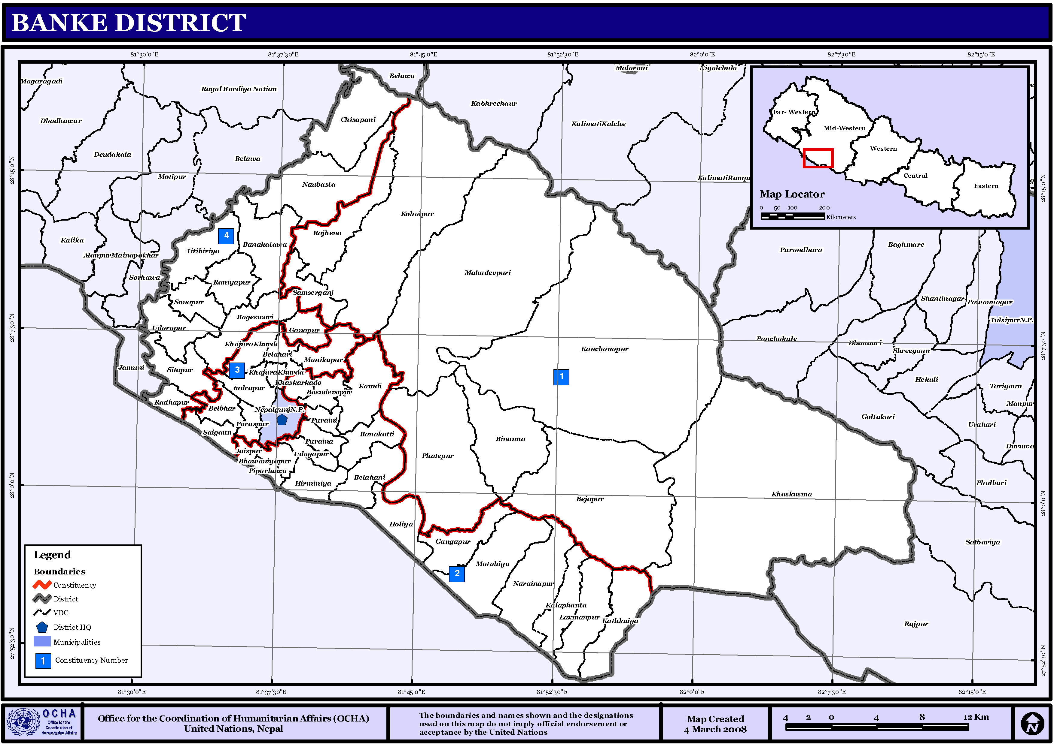
Banke District ( ne, बाँके जिल्ला , a part of Lumbini Province, is one of the 77 districts of Nepal. The district, located in midwestern Nepal with Nepalganj as its district headquarters, covers an area of and had a population of 385,840 in 2001 and 491,313 in 2011. There are three main cities in the Banke District: Nepalganj, Kohalpur and Khajura Bajaar. Geography and Climate Banke is bordered on the west by ''Bardiya district''. ''Rapti zone's'' ''Salyan'' and ''Dang Deukhuri Districts'' border to the north and east. To the south lies ''Uttar Pradesh'', India, a country in Asia; specifically ''Shravasti'' and ''Bahraich districts'' of ''Awadh''. East of Nepalganj the international border follows the southern edge of the ''Dudhwa Range'' of the ''Siwaliks''. Most of the district is drained by the ''Rapti'', except the district's western edge is drained by the ''Babai''. Rapti and Babai cross into Uttar Pradesh, a state in India, Nepal's neighboring c ... [...More Info...] [...Related Items...] OR: [Wikipedia] [Google] [Baidu] |
Salyan District, Nepal
Salyan District ( ne, सल्यान जिल्ला), a part of Karnali Province, is one of the seventy-seven districts of Nepal. Salyan covers an area of with a population of 213,500 in 2001 and 241,716 in 2011. The district's administrative center is named Salyan or ''Salyan Khalanga'', today it is part of Shaarada Municipality. The district is known for its Hindu temples including Shiva temples in Chhayachhetra and Laxmipur, and the Devi temple at Khairabang in Shaarada municipality, one of nine in Nepal. History Salyan was one of the '' Baise Rajya'', a confederation of 22 petty kingdoms in the Karnali (Ghagra) region. About 1760 CE all these kingdoms were annexed by the Shah Dynasty during the unification of Nepal. Etymology ''Salyan'' derives from the Nepali word ''sallo'' which means pine tree or conifer. Geography and climate Although Salyan is considered a hilly district, its southwest salient is actually outside the Pahari-inhabited hill region, in ... [...More Info...] [...Related Items...] OR: [Wikipedia] [Google] [Baidu] |


