|
Curahuara De Carangas
Curahuara de Carangas is a small town in the Bolivian Oruro Department. It is the seat of the Sajama Province. In 2009 it had an estimated population of 1,581. See also * Ch'iyar Quta * Sajama *Sajama National Park
Sajama National Park is a national park located in the Oruro Department, Bolivia. It borders Lauca National Park in Chile. The park is home to the indigenous Aymara people, whose influential ...
[...More Info...] [...Related Items...] OR: [Wikipedia] [Google] [Baidu] |
Departments Of Bolivia
Bolivia is a unitary state consisting of nine departments ( es, departamentos). Departments are the primary subdivisions of Bolivia, and possess certain rights under the Constitution of Bolivia. Each department is represented in the Plurinational Legislative Assembly—a bicameral legislature consisting of the Senate and the Chamber of Deputies. Each department is represented by four Senators, while Deputies are awarded to each department in proportion to their total population. Out of the nine departments, La Paz was originally the most populous, with 2,706,351 inhabitants as of 2012 but the far eastern department of Santa Cruz has since surpassed it by 2020; Santa Cruz also claims the title as the largest, encompassing . Pando is the least populated, with a population of 110,436. The smallest in area is Tarija, encompassing . Departments Former Departments By population Notes See also * ISO 3166-2:BO, the ISO codes for the departments of Bolivia. * Boliv ... [...More Info...] [...Related Items...] OR: [Wikipedia] [Google] [Baidu] |
Oruro Department
Oruro (; Quechua: ''Uru Uru''; Aymara: ''Ururu'') is a department of Bolivia, with an area of . Its capital is the city of Oruro. According to the 2012 census, the Oruro department had a population of 494,178. Provinces of Oruro The department is divided into 16 provinces which are further subdivided into municipalities and cantons. Note: Eduardo Abaroa Province (#5) is both north of and south of Sebastián Pagador Province (#6). Government The chief executive officer of Bolivian departments (since May 2010) is the governor; until then, the office was called the prefect, and until 2006 the prefect was appointed by the president of Bolivia. The current governor, Santos Tito of the Movement for Socialism – Political Instrument for the Sovereignty of the Peoples, was elected on 4 April 2010. The chief legislative body of the department is the Departmental Legislative Assembly, a body also first elected on 4 April 2010. It consists of 33 members: 16 elected by each ... [...More Info...] [...Related Items...] OR: [Wikipedia] [Google] [Baidu] |
Provinces Of Bolivia
A province is the second largest administrative division in Bolivia, after a department. Each department is divided into provinces. There are 112 provinces. The country's provinces are further divided into 337 municipalities which are administered by an alcalde and municipal council. List of provinces Beni Department Chuquisaca Department Cochabamba Department La Paz Department Oruro Department Pando Department Potosí Department Santa Cruz Department Tarija Department See also * Departments of Bolivia Bolivia is a unitary state consisting of nine departments ( es, departamentos). Departments are the primary subdivisions of Bolivia, and possess certain rights under the Constitution of Bolivia. Each department is represented in the Plurinatio ... * Municipalities of Bolivia Sources Instituto Nacional de Estadística - Bolivia(Spanish) {{Articles on second-level administrative divisions of South American countries S ... [...More Info...] [...Related Items...] OR: [Wikipedia] [Google] [Baidu] |
Sajama Province
Sajama is a province in the northwestern parts of the Bolivian Oruro Department. Location ''Sajama'' province is one of the sixteen provinces in the Oruro Department. It is located between 17° 39' and 18° 39' South and between 67° 38' and 68° 45' West. The province borders the La Paz Department in the north-west, the Republic of Chile in the west, Sabaya Province in the south-west, Litoral Province in the south-east, Carangas Province in the east, and San Pedro de Totora Province in the north-east. The province extends over 120 km from north to south, and 135 km from east to west. Geography The highest mountain in the province is the extinct Sajama volcano in the Sajama National Park. Other mountains are listed below:Bolivian IGM map 1:50,000 Cerro Uyarani Hoja 5838-I Population The main language of the province is Aymara, spoken by 90.4%, while 88.6% of the population speak Spanish and 4.2% Quechua (1992). The population increased from 7,891 inhabitants ... [...More Info...] [...Related Items...] OR: [Wikipedia] [Google] [Baidu] |
Municipalities Of Bolivia
Municipalities in Bolivia are administrative divisions of the entire national territory governed by local elections. Municipalities are the third level of administrative divisions, below departments and provinces. Some of the provinces consist of only one municipality. In these cases the municipalities are identical to the provinces they belong to. History of governance Municipalities in Bolivia are each led by a mayor, an executive office. Mayors were appointed by the national government from 1878 to 1942 and from 1949 to 1987. Local elections were held under the 1942 municipal code, which was in force until 1991. The 1985 Organic Law of Municipalities restored local elections for mayor and created a legislative body, the municipal council. In 1994, the entire territory of Bolivia was merged into municipalities, where previously only urban areas were organized as municipalities. As an effect of decentralization through the 1994 Law of Popular Participation the number of munic ... [...More Info...] [...Related Items...] OR: [Wikipedia] [Google] [Baidu] |
Cantons Of Bolivia
On the level below municipalities, Bolivia , image_flag = Bandera de Bolivia (Estado).svg , flag_alt = Horizontal tricolor (red, yellow, and green from top to bottom) with the coat of arms of Bolivia in the center , flag_alt2 = 7 × 7 square p ... is divided into 1374 cantons (''cantones''). Subdivisions of Bolivia {{bolivia-geo-stub ... [...More Info...] [...Related Items...] OR: [Wikipedia] [Google] [Baidu] |
Bolivia
, image_flag = Bandera de Bolivia (Estado).svg , flag_alt = Horizontal tricolor (red, yellow, and green from top to bottom) with the coat of arms of Bolivia in the center , flag_alt2 = 7 × 7 square patchwork with the (top left to bottom right) diagonals forming colored stripes (green, blue, purple, red, orange, yellow, white, green, blue, purple, red, orange, yellow, from top right to bottom left) , other_symbol = , other_symbol_type = Dual flag: , image_coat = Escudo de Bolivia.svg , national_anthem = " National Anthem of Bolivia" , image_map = BOL orthographic.svg , map_width = 220px , alt_map = , image_map2 = , alt_map2 = , map_caption = , capital = La Paz Sucre , largest_city = , official_languages = Spanish , languages_type = Co-official languages , languages ... [...More Info...] [...Related Items...] OR: [Wikipedia] [Google] [Baidu] |
Ch'iyar Quta, Oruro
__NOTOC__ Ch'iyar Quta ( Aymara ''ch'iyara'' black, ''quta'' lake, "black lake", hispanicized spellings ''Chiar Kkota'' and erroneously also ''Chiar Kkola'') is a small Bolivian lake located in the Sajama Province of the Oruro Department near the border to Chile. It is situated at a height of about inside the boundaries of the Sajama National Park. Dirk Hoffmann, The Sajama National Park in Bolivia, Mountain Research and Development Vol 27 No 1 February 2007 (see map on p. 12) Ch'iyar Quta lies south-east of the peaks of Laram Q'awa, Milluni and Kunturiri, south-west of Jisk'a Kunturiri and north of [...More Info...] [...Related Items...] OR: [Wikipedia] [Google] [Baidu] |
Sajama National Park
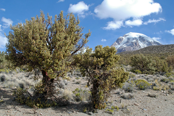
Sajama National Park is a national park located in the Oruro Department, Bolivia. It borders Lauca National Park in Chile. The park is home to the indigenous Aymara people, whose influential ancient culture can be seen in various aspects throughout the park. The park hosts many cultural and ecological sites, and is a hub of ecotourism. Many different indigenous plants and animals are exclusive to this area; therefore its continued conservation is of great ecological importance. Management of the park operates under a co-administrative approach, with local people and park conservationists engaging in a constant dialogue regarding park upkeep and policy. History Sajama National Park is Bolivia's oldest national park. The park lies within the Central Andean dry puna ecoregion. It features a spectacular Andean landscape, with elevations ranging from 4,200 to 6,542 meters (13,780 to 21,463 ft). It contains the snowy cone of the volcano Sajama, the highest mountain in Bolivia a ... [...More Info...] [...Related Items...] OR: [Wikipedia] [Google] [Baidu] |


