|
Culvestan
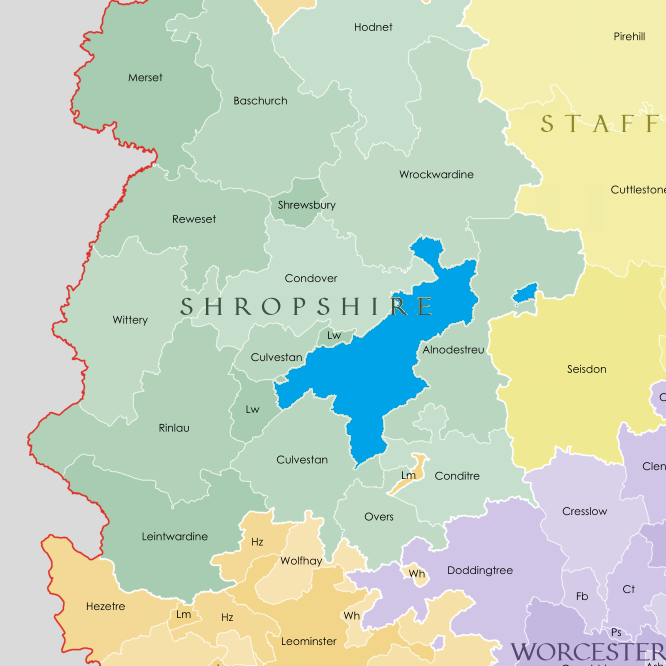
Culvestan was a hundred of Shropshire, England. Formed during Anglo-Saxon England, it encompassed manors in central southern Shropshire, and was amalgamated during the reign of Henry I (1100 to 1135) with the neighbouring hundred of Patton to form the Munslow hundred. The hundred of Culvestan centred on the lower Corvedale but also included the Strettondale, and stretched from Cardington in the north to Ashford in the south. At the time of the Domesday Book (1086) it betwixt Leintwardine hundred (which stretched northwards in the vicinity of the Roman road towards Wroxeter). The manors of Aldon, Bromfield, Stanton and Stokesay were notably well-populated manors in Culvestan as recorded in the Book. Stanton had the greatest population in the county measured by number of households, as well as the fourth-greatest monetary value. The four, plus Onibury, occupied an expansive area at the confluences of the Corve and Onny with the River Teme. Etymology The name consists o ... [...More Info...] [...Related Items...] OR: [Wikipedia] [Google] [Baidu] |
Munslow (hundred)
Munslow is a hundred of Shropshire, England. It was formed with the amalgamation of the Anglo-Saxon hundreds of Patton and Culvestan during the reign of Henry I (1100 to 1135). Hundreds in England had various judicial, fiscal and other local government functions, their importance gradually declining from the end of manorialism to the latter part of the 19th century. The hundred is named after the village of Munslow, where the hundred's judicial and administrative functions were mostly carried out. The 'hundred house' for Munslow hundred was originally located in neighbouring Aston Munslow, but from the Tudor period was located in Munslow itself. Geography The hundred was divided into "upper" and "lower" divisions (the "lower" division being considerably larger). The hundred reached from All Stretton to the north, down the valleys of the rivers Onny, Corve and Teme, to the Herefordshire border south and west of Ludlow. [...More Info...] [...Related Items...] OR: [Wikipedia] [Google] [Baidu] |
Patton (hundred)
Patton was a hundred of Shropshire, England. Formed during Anglo-Saxon England, it encompassed manors in eastern central Shropshire, and was amalgamated during the reign of Henry I (1100 to 1135) with the neighbouring hundred of Culvestan to form the Munslow hundred. It included the upper Corvedale and the well-populated manors of Wenlock, Stoke and Ditton. The original folkmoot place, which gave its name to the hundred, was Patton, a manor recorded as being part of the hundred in the 1086 Domesday Book. Patton is written in the Domesday Book variously as ''Patinton''(''e'') or ''Patintun''(''e''). Norman conquest Following the Norman conquest of England, many of the manors in the hundreds of Patton and Culvestan were owned by Roger de Montgomerie, 1st Earl of Shrewsbury. One of Montgomerie's holdings, Corfham was already by 1066 (when it was held by King Edward) the '' caput'' (the centre of administration) not only for Culvestan (the manor of Corfham being in that hu ... [...More Info...] [...Related Items...] OR: [Wikipedia] [Google] [Baidu] |
Onibury
Onibury is a village and Civil parishes in England, civil parish on the River Onny in southern Shropshire, about northwest of the market town of Ludlow. The parish includes the hamlets of Walton and Wootton and was extended in 1967 to include parts from Clungunford and Stokesay. It borders the parishes of Clungunford, Stokesay (now part of Craven Arms parish), Bromfield, Shropshire, Bromfield, Culmington and Stanton Lacy. The English country house, country houses of Ferney Hall and Stokesay Court are in the parish. History Toponym The Toponymy, toponym "Onibury" is derived from the Old English for "fortified place on the River Onny". "Onny" means "river on whose banks ash trees grew", from the Welsh language, Welsh "on" meaning ashes. Domesday Book Onibury is recorded in the Domesday Book of 1086 as ''Aneberie''. It had 15 households, making it a fairly medium-sized settlement for the time, and a priest. The Manorialism, manor formed part of the Saxon hundred (county division), ... [...More Info...] [...Related Items...] OR: [Wikipedia] [Google] [Baidu] |
River Corve
The River Corve is a minor river in Shropshire, England. It is a tributary of the River Teme which it joins in the town of Ludlow, and which joins the River Severn at Powick near Worcester. The valley it flows through is known as the Corvedale (or Corve Dale), a term used as a general name for the area, and a name used for example by the primary school in Diddlebury. It is sometimes (archaically) spelled "Corf", which is its pronunciation. Course It flows near Corfton (which it gives its name to), then by Culmington, then through Stanton Lacy and then through the northwest outskirts of Ludlow before joining the Teme in an area of meadows just outside the town. It also gave its name to Corfham Castle, near Peaton. Corfham was the ''caput'' (the centre of medieval administration) for two Saxon hundreds that encompassed the Corve Dale — Patton and Culvestan. They were merged into a single hundred (Munslow) in the reign of Henry I, however Culvestan continued to be a name used ... [...More Info...] [...Related Items...] OR: [Wikipedia] [Google] [Baidu] |
Ashford Carbonell
Ashford Carbonell (or Ashford Carbonel) is a village and civil parish in south Shropshire, England, near the county border with Herefordshire. The village lies south of the market town of Ludlow, on the eastern side of the River Teme, facing the smaller Ashford Bowdler. The river acts as the boundary between the parishes of Ashford Bowdler and Ashford Carbonel, and is crossed locally by Ashford Bridge, which takes the Caynham Road from the A49 towards Caynham.Ordnance Survey mapping The civil parish (which is formally named Ashford Carbonel) had a population of 321 as recorded in the 2011 census; the area covered by the parish is . History Ashford Carbonell formed part of the hundred of Culvestan, which in the 12th century became Munslow. Part of the parish (Huntington and The Serpent) however instead became part of the hundred of Stottesdon. Huntington was a manor mentioned (separately to Ashford Carbonell) in the Domesday Book (1086). Today it is a small hamlet just out ... [...More Info...] [...Related Items...] OR: [Wikipedia] [Google] [Baidu] |
Church Stretton
Church Stretton is a market town in Shropshire, England, south of Shrewsbury and north of Ludlow. The population in 2011 was 4,671.National Statistics Church Stretton 2011 population area and density The town was nicknamed Little Switzerland in the late and period for its landsc ... [...More Info...] [...Related Items...] OR: [Wikipedia] [Google] [Baidu] |
Bromfield, Shropshire
Bromfield is a village and civil parish in Shropshire, England. According to the 2001 census it had a population of 306, which had fallen to 277 at the 2011 census. Location Bromfield is located near the market town of Ludlow, two miles (3 km) northwest of the town centre, on the A49 road. The A4113 road (to Knighton) has its eastern end in Bromfield, at its junction with the A49. The village is situated near the confluence of the River Teme and River Onny. The latter splits the village into two, with the church and many of the older buildings to the west and the recently redeveloped business area to the east (towards Ludlow). A bridge takes the main road over the river. History The manor of Bromfield, and separately Bromfield Priory, are recorded in the Domesday Book of 1086, then still falling within the Saxon hundred of Culvestan, which was abolished in the reign of Henry I; Bromfield then came within Munslow hundred. It was a large and well-populated manor. The par ... [...More Info...] [...Related Items...] OR: [Wikipedia] [Google] [Baidu] |
Stanton Lacy
Stanton Lacy is a small village and geographically large civil parish located in south Shropshire, England, north of Ludlow. The River Corve flows through the parish, on its way south towards the River Teme, and passes immediately to the west of the village. The ancient parish church in the village is St Peter's. The building is Grade I listed and has pre- Norman parts dating to circa 1050. Parish The parish covers a wide rural area, encompassing a part of the flat and low-lying Corvedale but also an area of upland around Hayton's Bent (with the highest elevation being ). It contains a number of small settlements, including: * Stanton Lacy (the village) * Vernolds Common * The Hope * Lower Hayton * Upper Hayton * Hayton's Bent - location of Stanton Lacy Village Hall * Downton * Hoptongate The 2011 census recorded a resident population of 345. The geographic area of the parish is . The northern part of the Old Field (now occupied by Ludlow Racecourse and the Ludlow Go ... [...More Info...] [...Related Items...] OR: [Wikipedia] [Google] [Baidu] |
Stokesay
Stokesay is a historic hamlet (place), hamlet in Shropshire, England just south of Craven Arms on the A49 road, also fleetingly visible from the Shrewsbury to Hereford Welsh Marches Line, Welsh Marches railway line. Less than a mile to the north is the small town of Craven Arms and 6 miles to the south east is the larger, historical market town of Ludlow. Stokesay was once a civil parishes in England, civil parish, which covered the land now taken up by Craven Arms. However, in 1987 it merged with Halford, Shropshire, Halford parish to form the present Craven Arms parish. These two older entities continued as parish wards, however a review of the governance of Craven Arms in 2012 concluded in the abolition of these two wards from May 2013. The River Onny runs past Stokesay, on its way south, and the bridge which carries the A49 over the river is Stokesay Bridge. Within the former parish, to the south of the hamlet of Stokesay is Stoke Wood and the hamlet of Aldon (); to the north ... [...More Info...] [...Related Items...] OR: [Wikipedia] [Google] [Baidu] |
Leintwardine (hundred)
Leintwardine ( ) is a small to mid-size village and civil parish in north Herefordshire, England, close to the border with Shropshire. History Roman A popular misconception is that the Romans called the village ''Branogenium''. Branogenium in fact refers to a Roman fort roughly south of the village. The Roman name for Leintwardine was actually ''Bravonium''. The High Street in Leintwardine is on the same line as the Roman road known (to the English) as Watling Street. (The modern-day street in the village named Watling Street runs to the east of the original Watling Street, roughly on the alignment of the eastern edge of the Roman settlement.) The name Bravonium, as it appears in the Antonine Itinerary (Iter XII), is derived from the Romano-British word for quern. This suggests that there was either a hill or rock formation here that looked like a quern, or that there were quern quarries nearby. In the Upper Silurian series, the Leintwardine beds outcrop in the area and these ... [...More Info...] [...Related Items...] OR: [Wikipedia] [Google] [Baidu] |
River Onny
The River Onny is a river in Shropshire, England. It is a major tributary of the River Teme. Etymology The river's name derives from Welsh and means the river on which ash trees (Welsh: ''onnau'') grew. Course The river has its sources in the Shropshire Hills at White Grit, located in Mid and South-west Shropshire. It has two branches, the East Onny and West Onny, which converge at Eaton, to the east of Lydham. The River Onny then flows in a south-easterly direction, through Craven Arms and Onibury (a village it gives its name to), before it finally has its confluence with the River Teme just upstream of Ludlow at Bromfield. From White Grit to Bromfield, the river flows over a distance of . The River Teme is itself a tributary of the River Severn, confluencing just south of Worcester city centre. The River Severn then flows south-west meeting the sea at Bristol Channel The Bristol Channel ( cy, Môr Hafren, literal translation: "Severn Sea") is a major inlet in ... [...More Info...] [...Related Items...] OR: [Wikipedia] [Google] [Baidu] |


