|
Congo-Kasaï Province
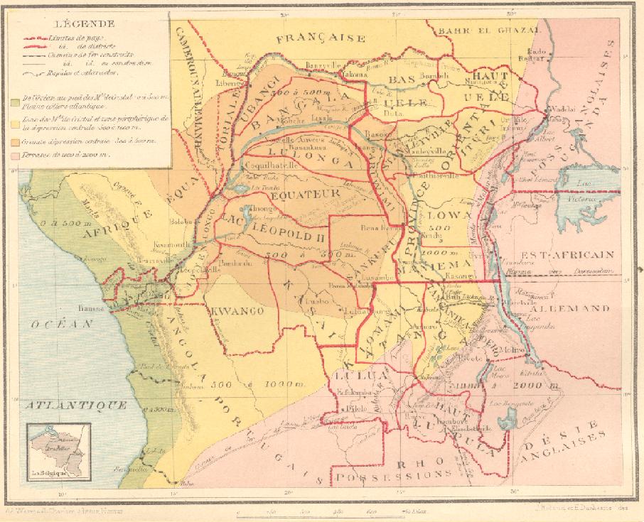
Congo-Kasaï was one of the four large provinces of the Belgian Congo defined in 1914. It was formally established in 1919, and in 1933 was divided into the new provinces of Léopoldville and Lusambo. Location Congo-Kasaï was named after the Kasai River, a major left tributary of the Congo River that provides access to the region. By 1910 a factory of the Kasai Company had been established near Misumba, which had about two thousand inhabitants. The company had made successful trial rubber plantations. The company also bought rubber and ivory from the local people, some of whom used it to buy liquor from the Portuguese territory (Angola). Congo-Kasaï had five districts: the urban district of Léopoldville, capital of the colony, and the districts (from west to east) of Bas-Congo, Kwango, Kasaï and Sankuru. The ''Huileries du Congo Belge'' company had two zones (or circles) of exploitation in the province based on Brabanta and Leverville, of which Leverville was the mos ... [...More Info...] [...Related Items...] OR: [Wikipedia] [Google] [Baidu] |
Kasaï District
Kasai District (french: District du Kasai, nl, District Kasai) was a district of the Congo Free State, Belgian Congo and the Democratic Republic of the Congo, named after the Kasai River. It was formed around 1885 and went through several large changes in extent in the years that followed. The 1933 version of the district roughly corresponded to the former Kasai-Occidental province and the present Kasaï and Kasaï-Central provinces. Congo Free State A decree of 3 September 1886 by the Congo Free State administrator general Camille Janssen defined nine districts in the colony, each headed by a district commissioner, including Lubuku-Kassaï District. Article 3 of the decree of 16 April 1887 provided for the Congo Free State to be divided into administrative districts headed by district commissioners, assisted by one or more deputies. The decree of 1 August 1888 divided the Congo Free State into eleven districts, in including the Kasai District with headquarters at Luluabourg. ... [...More Info...] [...Related Items...] OR: [Wikipedia] [Google] [Baidu] |
List Of Governors Of Kasaï (former Province)
This list of governors of Kasaï includes governors or equivalent officeholders of the Congo-Kasaï/Kongo-Kasaï province established in the Belgian Congo in 1918. On 1 October 1933 it was split into the Lusambo and Léopoldville provinces. Lusambo included the Kasaï and Sankuru districts of Congo-Kasaï and parts of the Léopold II District (Équateur) and Lomami District (Katanga). On 27 May 1947 Lusambo was renamed Kasaï, which became an autonomous province of the Congo republic on 30 June 1960. On 14 August 1962 Kasaï was divided into five new provinces: Lomami, Luluabourg, Sankuru, Sud-Kasaï and Unité Kasaïenne. On 25 April 1966 Luluabourg and Unité Kasaïenne were united to form Kasaï-Occidental, while Lomami, Sankuru, and Sud-Kasaï were united in the new province of Kasaï-Oriental. Kasaï-Occidental was split in 2015 into the Kasaï-Central and Kasaï provinces. Congo-Kasaï (1922–1932) The governors (or equivalent) of Congo-Kasaï Province were: ... [...More Info...] [...Related Items...] OR: [Wikipedia] [Google] [Baidu] |
Katanga Province
Katanga was one of the four large provinces created in the Belgian Congo in 1914. It was one of the eleven provinces of the Democratic Republic of the Congo between 1966 and 2015, when it was split into the Tanganyika Province, Tanganyika, Haut-Lomami, Lualaba Province, Lualaba, and Haut-Katanga provinces. Between 1971 and 1997 (during the rule of Mobutu Sese Seko when Congo was known as Zaire), its official name was Shaba Province. Katanga's area encompassed . Farming and ranching are carried out on the Katanga Plateau. The eastern part of the province is considered to be a rich mining region, which supplies cobalt, copper, tin, radium, uranium, and diamonds. The region's former capital, Lubumbashi, is the second-largest city in the Congo. History Copper mining in Katanga dates back over 1,000 years, and mines in the region were producing standard-sized ingots of copper for international transport by the end of the 10th century CE. In the 1890s, the province was beleaguered ... [...More Info...] [...Related Items...] OR: [Wikipedia] [Google] [Baidu] |
Orientale Province
Orientale Province ( French: ''Province orientale'', "Eastern province") is one of the former provinces of the Democratic Republic of the Congo and its predecessors the Congo Free State and the Belgian Congo. It went through a series of boundary changes between 1898 and 2015, when it was divided into smaller units. The District of Orientale Province was created from Stanley Falls District on 15 July 1898. The district was expanded to become Orientale Province in 1913. It was divided in 1933 into Costermansville (later Kivu) and Stanleyville Province. Stanleyville Province was renamed Orientale Province from 1947 to 1963, when it was broken up into Kibali-Ituri, Uélé and Haut-Congo provinces. Orientale Province was reconstituted in 1966. Between 1971 and 1997 it was called Haut-Zaïre, then it returned to the name of Orientale. The province contained the Bas-Uele, Haut-Uele, Ituri and Tshopo districts. These were elevated to provinces in 2015 under the 2006 constitution. Th ... [...More Info...] [...Related Items...] OR: [Wikipedia] [Google] [Baidu] |
Équateur (former Province)
Équateur ( French for "Equator") was a province in the northwest of the Belgian Congo and the successor Republic of the Congo, now known as Democratic Republic of the Congo. It had its origins in the Équateur District of the Congo Free State, the private property of King Leopold II of Belgium. It was upgraded to the status of a province in 1917. Between 1933 and 1947 it was named Coquilhatville. In 1962 it was divided into three smaller provinces, but there were recombined in 1966. Équateur was one of the eleven provinces of the Democratic Republic of the Congo until 2015, when it was split into the new, smaller Équateur province, as well as the Tshuapa, Mongala, Nord-Ubangi and Sud-Ubangi provinces. Located in the north of the country, the province bordered the Republic of the Congo to the west, the Central African Republic to the north, to the east the Orientale province, and to the south the Kasai-Oriental, Kasai-Occidental, and Bandundu provinces. The word "Équateu ... [...More Info...] [...Related Items...] OR: [Wikipedia] [Google] [Baidu] |
Leverville
Lusanga (formerly Leverville) is a town in Kwilu province of the Democratic Republic of the Congo. It is at the confluence of the Kwenge and Kwilu rivers. The town is served by a small airport (IATA Code: LUS). In the colonial era the town was called Leverville. It was named after William Lever of the Lever Brothers, which started as a soap-making business and grew into the Unilever Unilever plc is a British multinational consumer goods company with headquarters in London, England. Unilever products include food, condiments, bottled water, baby food, soft drink, ice cream, instant coffee, cleaning agents, energy dri ... consumer goods giant. In 1911 Lever signed a treaty with the Belgian government to gain access to the palm oil of the colony, and established the main coordinating base at Leverville. The Huileries du Congo Belge (HCB), a subsidiary of Lever Brothers, established a large palm oil factory at Leverville, one of three in Kwilu. References Sources * ... [...More Info...] [...Related Items...] OR: [Wikipedia] [Google] [Baidu] |
Huileries Du Congo Belge
Huileries du Congo Belge (HCB) was a subsidiary of the soap manufacturing company Lever Brothers, created by William Hesketh Lever, which ran plantations in the Congo for the production of palm oil, using forced labour. It was established in 1911, when the soap manufacturer received a concession from the Belgian government for of forest in the Belgian Congo, mostly south of Bandundu. By 1923, a Lever soap factory was built there, and by 1924 SAVCO (Savonneries Congolaises) was established. It was the nucleus of the United Africa Company, a principal supplier to the United Kingdom of several key commodities. From 1951 it was producing Lux soap. The company produced palm oil for Lever Brothers and its successor company Unilever. Huileries du Congo Belge was at one time known as ''Plantations Lever au Congo'' with Plantations Lever au Zaire, and is now known as ''Plantations et huileries du Congo'' (PHC). In 2009, Unilever sold PHC to Feronia Inc, who took over the operation ... [...More Info...] [...Related Items...] OR: [Wikipedia] [Google] [Baidu] |
Sankuru District
Sankuru District (french: District du Sankuru, nl, District Sankuru) was a district of the Belgian Congo and Democratic Republic of the Congo. It went through various changes in extent, but roughly corresponded to the modern Sankuru Province. Location A 1914 map shows Sankuru roughly in the center of the Belgian Congo, bordered by Kasai District and Lac Leopold II District to the west, Équateur District and Aruwimi District to the north, Maniema District in the Orientale Province to the east, and Lomami District in Katanga to the south. Sankuru District covered the upper part of the Lukenie River basin and a section of the Lubilash River, which originates further south in Lomami District. Colonial history Between 1910 and 1912 Kasai District was divided into Sankuru District to the northeast and a smaller Kasai District to the southwest. As of 1926 both these districts were in the Congo-Kasaï province. The people of the west of Sankuru District were stirred up at the en ... [...More Info...] [...Related Items...] OR: [Wikipedia] [Google] [Baidu] |
Kwango District
Kwango District (french: District du Kwango, nl, District Kwango) was a district of the Congo Free State, Belgian Congo and the Democratic Republic of the Congo. It went through various changes in extent. It roughly corresponded to the present provinces of Kwilu and Kwango. Congo Free State In 1895 the number of the districts in the Congo Free State was increased to fifteen. The districts now included Kwango District. It had been carved out of the west of the Kasai District. A map of the Congo Free State in 1897 shows the Kwango Oriental district bounded by the Stanley Pool District to the west, the Lualaba Kassai District to the east, and Portuguese possessions (Angola) to the south. The district extended south from the point where the combined Kwango and Kwilu rivers entered the Kasai River, and included the watershed of the Wamba River. The Kwango River formed the border with the Portuguese territory to the west, and the eastern boundary was to the east of the Kwilu River. ... [...More Info...] [...Related Items...] OR: [Wikipedia] [Google] [Baidu] |

