|
Communes Of Trentino
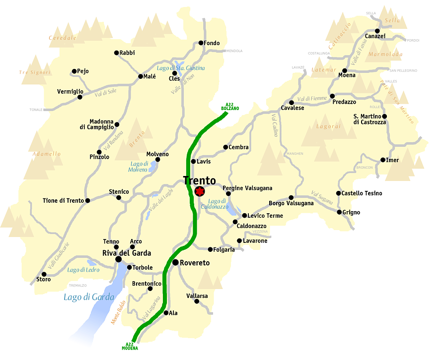
The list shows the municipalities (''comuni'') of the autonomous province of Trento, Italy. Trentino is divided into 176 administrative subdivisions (''Comuni/ Gemeinden''). Some municipalities have a second official language such as German (Cimbrian and Mócheno) and Ladin. Most German names of municipalities however are historical apart from the previously mentioned communities. The Ladin variety of the Fassa Valley is currently the only officially recognized one, in contrast to the varieties of Non and Sole Valley). See also * Municipalities of South Tyrol * Prontuario dei nomi locali dell'Alto Adige The Prontuario dei nomi locali dell'Alto Adige (Italian for ''Reference Work of Place Names of Alto Adige'') is a list of Italianized toponyms for mostly German place names in South Tyrol (''Alto Adige'' in Italian) which was published in 1916 by ... {{Trentino ... [...More Info...] [...Related Items...] OR: [Wikipedia] [Google] [Baidu] |
Comuni
The (; plural: ) is a local administrative division of Italy, roughly equivalent to a township or municipality. It is the third-level administrative division of Italy, after regions ('' regioni'') and provinces (''province''). The can also have the title of ('city'). Formed ''praeter legem'' according to the principles consolidated in medieval municipalities, the is provided for by art. 114 of the Constitution of Italy. It can be divided into ''frazioni'', which in turn may have limited power due to special elective assemblies. In the autonomous region of the Aosta Valley, a ''comune'' is officially called a ''commune'' in French. Overview The provides essential public services: registry of births and deaths, registry of deeds, and maintenance of local roads and public works. Many have a '' Polizia Comunale'' (communal police), which is responsible for public order duties. The also deal with the definition and compliance with the (general regulator plan), a document ... [...More Info...] [...Related Items...] OR: [Wikipedia] [Google] [Baidu] |
Albiano
Albiano is a ''comune'' in the autonomous province of Trentino in north Italy. Sport The local amateur football club, A.S.D. Porfido Albiano, currently plays in the Eccellenza Trentino-Alto Adige/Südtirol Eccellenza Trentino-Alto Adige/Südtirol ( it, Eccellenza Trentino-Alto Adige) is the regional Eccellenza football division for clubs in the northern Italian region of Trentino-Alto Adige/Südtirol, Italy. It is competed amongst 16 teams, in one g .... References External links Homepage of the city Cities and towns in Trentino-Alto Adige/Südtirol {{TrentinoAltoAdige-geo-stub ... [...More Info...] [...Related Items...] OR: [Wikipedia] [Google] [Baidu] |
Map Of Comune Of Arco (province Of Trento, Region Trentino-South Tyrol, Italy) 2018
A map is a symbolic depiction emphasizing relationships between elements of some space, such as objects, regions, or themes. Many maps are static, fixed to paper or some other durable medium, while others are dynamic or interactive. Although most commonly used to depict geography, maps may represent any space, real or fictional, without regard to context or scale, such as in brain mapping, DNA mapping, or computer network topology mapping. The space being mapped may be two dimensional, such as the surface of the earth, three dimensional, such as the interior of the earth, or even more abstract spaces of any dimension, such as arise in modeling phenomena having many independent variables. Although the earliest maps known are of the heavens, geographic maps of territory have a very long tradition and exist from ancient times. The word "map" comes from the , wherein ''mappa'' meant 'napkin' or 'cloth' and ''mundi'' 'the world'. Thus, "map" became a shortened term referring to ... [...More Info...] [...Related Items...] OR: [Wikipedia] [Google] [Baidu] |
Arco, Trentino
Arco is a ''comune'' in Trentino-Alto Adige in northern Italy. The town is faced on one side by sheer limestone cliffs jutting up like a wall protecting it and its ancient hilltop castle. King Francis II of the Two Sicilies died here in 1894. Main sights *The Castello di Arco, medieval castle *Sanctuary and convent of ''Santa Maria delle Grazie'', built in 1475–1492. It houses a wooden statue of the Virgin Mary dating to the 15th century *''Collegiata dell'Assunta'', begun in 1613. Francis II, the last King of Two Sicilies, was provisionally buried here in the late 19th century, after his death at Arco in 1894. *Church of ''Sant'Apollinare'', with 14th-century frescoes *''Palazzo Marchettii'' (16th century). It has a portal attributed to Giulio Romano. *''Palazzo dei Panni'' (late 17th century) *''Stations of the Cross'' to the chapel "Santuario della Madonna di Laghel" 1896 by Josef Moroder-Lusenberg Economy Tourism is a major part of the local economy, with many Ge ... [...More Info...] [...Related Items...] OR: [Wikipedia] [Google] [Baidu] |
Map Of Comune Of Andalo (province Of Trento, Region Trentino-South Tyrol, Italy) 2018
A map is a symbolic depiction emphasizing relationships between elements of some space, such as objects, regions, or themes. Many maps are static, fixed to paper or some other durable medium, while others are dynamic or interactive. Although most commonly used to depict geography, maps may represent any space, real or fictional, without regard to context or scale, such as in brain mapping, DNA mapping, or computer network topology mapping. The space being mapped may be two dimensional, such as the surface of the earth, three dimensional, such as the interior of the earth, or even more abstract spaces of any dimension, such as arise in modeling phenomena having many independent variables. Although the earliest maps known are of the heavens, geographic maps of territory have a very long tradition and exist from ancient times. The word "map" comes from the , wherein ''mappa'' meant 'napkin' or 'cloth' and ''mundi'' 'the world'. Thus, "map" became a shortened term referring to ... [...More Info...] [...Related Items...] OR: [Wikipedia] [Google] [Baidu] |
Andalo
Andalo (''Àndel'' in local dialect) is a ''comune'' (municipality) in Trentino in north Italy, with some 1,200 inhabitants in 2021. It is the seat of the Comunità di Valle dell'Altopiano della Paganella. Geography The town lies on the Paganella plateau, between the mountains Piz Galin, elevation , and Paganella, , and its territory is part of the Adamello-Brenta natural park. History The area was first settled during the Middle Ages, and used to be divided into 13 hamlets called “masi” (Bortolon, Cadin, Casanova, Clamer, Dos, Fovo, Ghezzi, Melchiori, Monech, Pegorar, Perli, Pont and Toscana), which eventually merged into a single town. This fragmentation can still be noticed, especially in the most isolated masi (for instance, maso Pegorar). During the second part of the 20th century the village became one of the most famous touristic resorts in Trentino, mainly due to its skiing facilities. Economy The local economy, once reliant exclusively on agriculture, is no ... [...More Info...] [...Related Items...] OR: [Wikipedia] [Google] [Baidu] |
Map Of Comune Of Amblar-Don (province Of Trento, Region Trentino-South Tyrol, Italy) 2018
A map is a symbolic depiction emphasizing relationships between elements of some space, such as objects, regions, or themes. Many maps are static, fixed to paper or some other durable medium, while others are dynamic or interactive. Although most commonly used to depict geography, maps may represent any space, real or fictional, without regard to context or scale, such as in brain mapping, DNA mapping, or computer network topology mapping. The space being mapped may be two dimensional, such as the surface of the earth, three dimensional, such as the interior of the earth, or even more abstract spaces of any dimension, such as arise in modeling phenomena having many independent variables. Although the earliest maps known are of the heavens, geographic maps of territory have a very long tradition and exist from ancient times. The word "map" comes from the , wherein ''mappa'' meant 'napkin' or 'cloth' and ''mundi'' 'the world'. Thus, "map" became a shortened term referring to ... [...More Info...] [...Related Items...] OR: [Wikipedia] [Google] [Baidu] |
Amblar-Don
Amblar-Don is a ''comune'' of the Val di Non in the Trentino, northern Italy. It came into existence on 1 January 2016 through the merger of the formerly separate ''comuni'' of Amblar and Don Don, don or DON and variants may refer to: Places *County Donegal, Ireland, Chapman code DON *Don (river), a river in European Russia *Don River (other), several other rivers with the name *Don, Benin, a town in Benin *Don, Dang, a vill .... References Municipalities of Trentino {{TrentinoAltoAdige-geo-stub ... [...More Info...] [...Related Items...] OR: [Wikipedia] [Google] [Baidu] |
Map Of Comune Of Altopiano Della Vigolana (province Of Trento, Region Trentino-South Tyrol, Italy) 2018
A map is a symbolic depiction emphasizing relationships between elements of some space, such as objects, regions, or themes. Many maps are static, fixed to paper or some other durable medium, while others are dynamic or interactive. Although most commonly used to depict geography, maps may represent any space, real or fictional, without regard to context or scale, such as in brain mapping, DNA mapping, or computer network topology mapping. The space being mapped may be two dimensional, such as the surface of the earth, three dimensional, such as the interior of the earth, or even more abstract spaces of any dimension, such as arise in modeling phenomena having many independent variables. Although the earliest maps known are of the heavens, geographic maps of territory have a very long tradition and exist from ancient times. The word "map" comes from the , wherein ''mappa'' meant 'napkin' or 'cloth' and ''mundi'' 'the world'. Thus, "map" became a shortened term referring to ... [...More Info...] [...Related Items...] OR: [Wikipedia] [Google] [Baidu] |
Altopiano Della Vigolana
Altopiano della Vigolana is a ''comune'' (municipality) in Trentino in the northern Italian region Trentino-Alto Adige/Südtirol, located about south-east of Trento. It was formed on 1 January 2016 as the merger of the previous Municipalities of Bosentino, Centa San Nicolò, Vattaro and Vigolo Vattaro Vigolo Vattaro (''Vìgol'' in local dialect) is a ''comune'' (municipality) in Trentino in the northern Italian region Trentino-Alto Adige/Südtirol, located about southeast of Trento. As of 31 December 2004, it had a population of 1,985 and an a .... References External links Official website Cities and towns in Trentino-Alto Adige/Südtirol {{TrentinoAltoAdige-geo-stub ... [...More Info...] [...Related Items...] OR: [Wikipedia] [Google] [Baidu] |
Map Of Comune Of Altavalle (province Of Trento, Region Trentino-South Tyrol, Italy) 2018
A map is a symbolic depiction emphasizing relationships between elements of some space, such as objects, regions, or themes. Many maps are static, fixed to paper or some other durable medium, while others are dynamic or interactive. Although most commonly used to depict geography, maps may represent any space, real or fictional, without regard to context or scale, such as in brain mapping, DNA mapping, or computer network topology mapping. The space being mapped may be two dimensional, such as the surface of the earth, three dimensional, such as the interior of the earth, or even more abstract spaces of any dimension, such as arise in modeling phenomena having many independent variables. Although the earliest maps known are of the heavens, geographic maps of territory have a very long tradition and exist from ancient times. The word "map" comes from the , wherein ''mappa'' meant 'napkin' or 'cloth' and ''mundi'' 'the world'. Thus, "map" became a shortened term referring to ... [...More Info...] [...Related Items...] OR: [Wikipedia] [Google] [Baidu] |
Altavalle
Altavalle is a ''comune'' (municipality) in Trentino in the northern Italian region Trentino-Alto Adige/Südtirol. It was formed on 1 January 2016 as the merger of the previous communes of Faver, Grauno, Grumes Grumes (german: Grumeis) is a ''frazione'' of the ''comune'' of Altavalle in Trentino in the northern Italian region Trentino-Alto Adige/Südtirol, located about northeast of Trento Trento ( or ; Ladin and lmo, Trent; german: Trient ; cim, ... and Valda. References External links Official website Cities and towns in Trentino-Alto Adige/Südtirol {{TrentinoAltoAdige-geo-stub ... [...More Info...] [...Related Items...] OR: [Wikipedia] [Google] [Baidu] |


