|
Columbia Valley
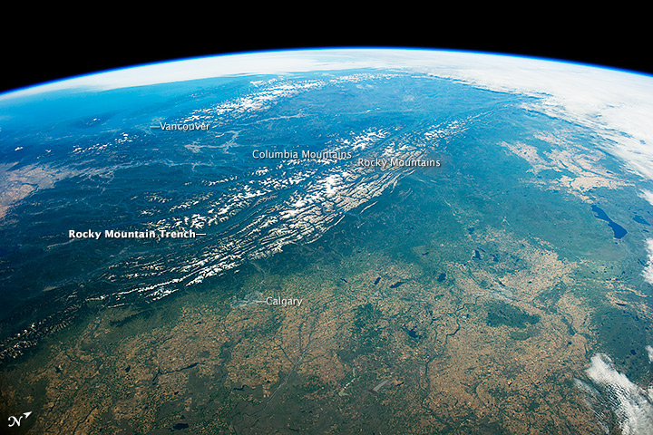
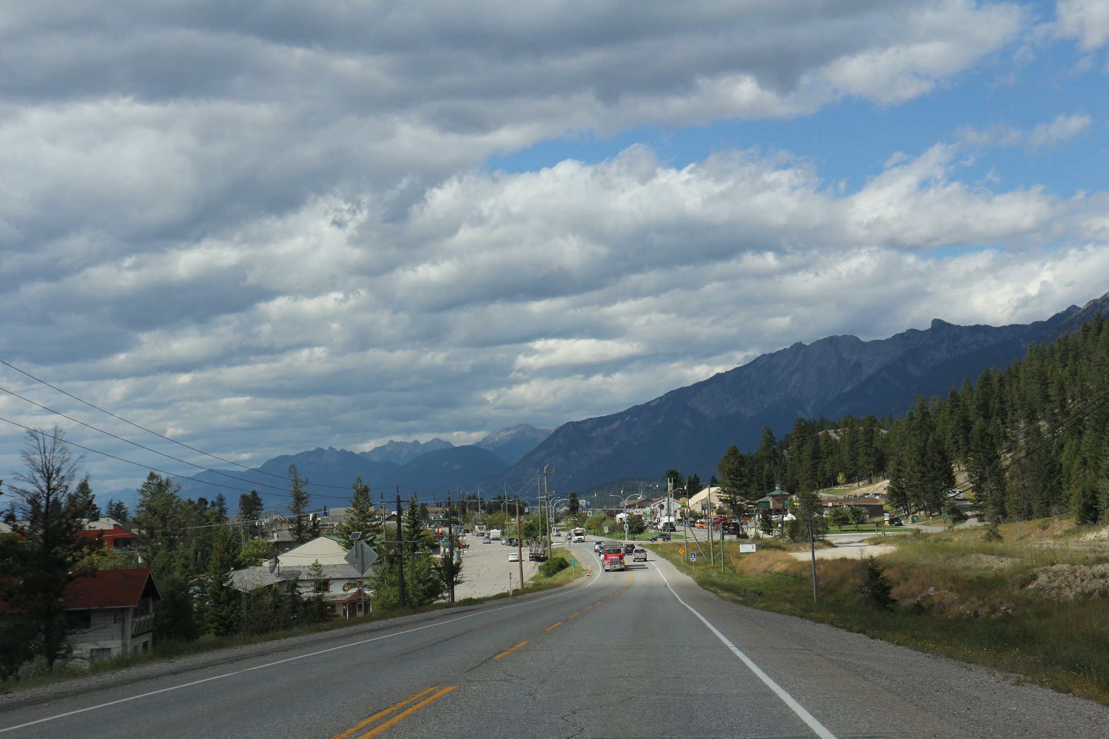
The Columbia Valley is the name used for a region in the Rocky Mountain Trench near the headwaters of the Columbia River between the town of Golden and the Canal Flats. The main hub of the valley is the town of Invermere. Other towns include Radium Hot Springs, Windermere and Fairmont Hot Springs. The Panorama Ski Resort is located near the valley. The Columbia Valley is home to the Columbia Wetlands, a vital link on a major bird migration route. External links Columbia Headwaters Legacy ProgramColumbia Valley, BC��Business Directory, Local Online Newspaper, Live Webcams Valleys of British Columbia {{BritishColumbiaInterior-geo-stub ... [...More Info...] [...Related Items...] OR: [Wikipedia] [Google] [Baidu] |
Rocky Mountain Trench
The Rocky Mountain Trench, also known as the Valley of a Thousand Peaks or simply the Trench, is a large valley on the western side of the northern part of North America's Rocky Mountains. The Trench is both visually and cartographically a striking physiographic feature extending approximately from Flathead Lake, Montana, to the Liard River, just south of the British Columbia–Yukon border near Watson Lake, Yukon. The trench bottom is wide and is above sea level. The general orientation of the Trench is an almost straight 150/330° geographic north vector and has become convenient as a visual guide for aviators heading north or south. Although some of its topography has been carved into U-shaped glacial valleys, it is primarily a byproduct of geologic faulting. The Trench separates the Rocky Mountains on its east from the Columbia Mountains and the Cassiar Mountains on its west. It also skirts part of the McGregor Plateau area of the Nechako Plateau sub-area of t ... [...More Info...] [...Related Items...] OR: [Wikipedia] [Google] [Baidu] |
Columbia River
The Columbia River ( Upper Chinook: ' or '; Sahaptin: ''Nch’i-Wàna'' or ''Nchi wana''; Sinixt dialect'' '') is the largest river in the Pacific Northwest region of North America. The river rises in the Rocky Mountains of British Columbia, Canada. It flows northwest and then south into the U.S. state of Washington, then turns west to form most of the border between Washington and the state of Oregon before emptying into the Pacific Ocean. The river is long, and its largest tributary is the Snake River. Its drainage basin is roughly the size of France and extends into seven US states and a Canadian province. The fourth-largest river in the United States by volume, the Columbia has the greatest flow of any North American river entering the Pacific. The Columbia has the 36th greatest discharge of any river in the world. The Columbia and its tributaries have been central to the region's culture and economy for thousands of years. They have been used for transportat ... [...More Info...] [...Related Items...] OR: [Wikipedia] [Google] [Baidu] |
Golden, British Columbia
Golden is a town in southeastern British Columbia, Canada, west of Calgary, Alberta, and east of Vancouver. History In 1807, David Thompsonrenowned fur trader, surveyor, and map-makerwas tasked by the North West Company to open a trading route to the lucrative trading territories of the Pacific Northwest. He first crossed over the Rocky Mountains and travelled along the Blaeberry River to the future site of Golden. In 1881 the Canadian Pacific Railway (CPR) hired surveyor A. B. Rogers to find a rail route through the Selkirk and Rocky Mountains, and in 1882 he found the pass now named for him. Rogers established a base camp for his survey crew led by a man named McMillan. Initially known as McMillan's Camp, the settlement was the beginning of the town of Golden. By 1884, in response to a nearby lumber camp naming itself Silver City, the residents of McMillan's Camp, headed by Baptiste Morigeau, decided not to be outdone and renamed the settlement Golden City. The 'city' des ... [...More Info...] [...Related Items...] OR: [Wikipedia] [Google] [Baidu] |
Canal Flats
Canal Flats is a village municipality in the East Kootenay region of southeastern British Columbia. This Columbia Valley community lies between the southern end of Columbia Lake and the northwest shore of the Kootenay River. The locality, on Highway 93/95, is by road about north of Cranbrook and southeast of Golden. First Nations The Ktunaxa Nation has occupied the region around Canal Flats for thousands of years. On a bluff just to the south, remnants of shelter pits evidence a former Ktunaxa salmon fishing camp. Differing versions exist of the missionary endeavours of Father Pierre-Jean DeSmet of the Jesuits. According to one account, he organized a great assembly at the south end of Columbia Lake in 1845, where he baptized hundreds of tribal members. Afterward, he erected a cross in a prominent place to commemorate the occasion. Relocated to the village in 2011, a log building to house the Columbia Discovery Centre and Ktunaxa Interpretive Centre opened in 2013. Name or ... [...More Info...] [...Related Items...] OR: [Wikipedia] [Google] [Baidu] |
Invermere
Invermere is a community in eastern British Columbia, Canada, near the border of Alberta. It is the hub of the Columbia Valley between Golden to the north and Cranbrook to the south. Invermere sits on the northwest shore of Windermere Lake and is a popular summer destination for visitors and second home owners from Edmonton and Calgary. Geography Invermere is located south of Radium, and south of Golden and from the Trans-Canada Highway. Invermere is also north of Fairmont Hot Springs, north of Canal Flats, north of Fort Steele, north of Kimberley, and north of the hub of Cranbrook and the Crowsnest Highway. Invermere is situated within the Columbia River Wetlands, North America's largest intact wetland and a Ramsar-designated site. Located in the Rocky Mountain Trench, Invermere is from Kootenay National Park, and is near the Purcell Wilderness Conservancy. Climate Invermere's climate is characterized by warm summers and cool winters. The Rocky Mountains t ... [...More Info...] [...Related Items...] OR: [Wikipedia] [Google] [Baidu] |
Radium Hot Springs
Radium Hot Springs, informally and commonly called Radium, is a village of 1,339 residents situated in the East Kootenay region of British Columbia. The village is named for the hot springs located in the nearby Kootenay National Park. From Banff, Alberta, it is accessible via Highway 93. The hot springs were named after the radioactive element when an analysis of the water showed that it contained small traces of radon which is a decay product of radium. The radiation dosage from bathing in the pools is inconsequential; approximately from the water for a half-hour bathing, around ten times average background levels. The air concentration of radon is about which is higher than the level () at which mitigation within two years is encouraged at residences; but is also inconsequential (about for a half-hour bathing) from a dose impact perspective. Geography Radium is located 16 km north of the tourist town of Invermere, and 105 km south of Golden, British Columbia. It ... [...More Info...] [...Related Items...] OR: [Wikipedia] [Google] [Baidu] |
Windermere, British Columbia
Windermere is a community and designated place located south of Invermere on Windermere Lake in the Regional District of East Kootenay. Demographics *Population (2021): 1,511 *Population ( 2016): 1,092 *Population ( 2011): 1,081 *Population ( 2006): 1,259 *Population (2001 The September 11 attacks against the United States by Al-Qaeda, which killed 2,977 people and instigated the global war on terror, were a defining event of 2001. The United States led a multi-national coalition in an invasion of Afghanistan ...): 1,060 References External links Windermere on British Columbia website {{authority control Populated places in the Regional District of East Kootenay Designated places in British Columbia ... [...More Info...] [...Related Items...] OR: [Wikipedia] [Google] [Baidu] |
Fairmont Hot Springs, British Columbia
Fairmont Hot Springs is an unincorporated resort community located in south-eastern British Columbia, Canada commonly referred to as Fairmont. The community has a population of 476, but receives frequent tourists. The local resort is centered around a soak pool and swimming pool fed by natural mineral hot springs. The original springs building, surrounded by hot spring water seeping out of the ground, still stands. The community contains three golf courses: Mountainside and Riverside are 18-hole courses, while Creekside is a family-oriented 9-hole par 3. In the winter, the area is also home to a small downhill ski area, with three lifts (one double chair and two surface lifts), 13 runs and a tube park, as well as numerous cross-country trails. Fairmont Hot Springs has a strip mall including a market, restaurants, and a gift shop. Fairmont Hot Springs is home to the Dutch Creek Hoodoos, which are sandstone cliffs ( hoodoos) with hiking trails located next to Dutch Creek, a source of ... [...More Info...] [...Related Items...] OR: [Wikipedia] [Google] [Baidu] |
Panorama Mountain Village
Panorama Mountain Resort is a ski and golf resort in Canada, located in the Purcell Mountains of southeastern British Columbia. Part of the Columbia Valley sub-region of the East Kootenay region, it is a tourist destination known for its rolling cliffs and views of the Rocky Mountains. It is privately owned by Panorama Mountain Village Inc. History Panorama was founded in 1962 by Fritz Zehnder of Invermere and Guy Messerli of Switzerland, and some friends. The original facilities consisted of a warming hut, parking lot, and single rope tow, running on a V8, which ran transported users up the bottom of a ski run now known as "Old Timer". The area took its name from a nearby hiking area called the "Panorama Plateau". In 1964, a platter, purchased from nearby Sunshine Village, was installed to replace the rope tow. During these initial years, the ski hill was volunteer-run. In 1968, 12 local businessmen formed a group called Panorama Ski Hill Company Ltd to manage and grow the s ... [...More Info...] [...Related Items...] OR: [Wikipedia] [Google] [Baidu] |
Columbia Wetlands
The Columbia Wetlands is a 15,070 hectare wetland in the Columbia Valley region of southeastern British Columbia, Canada. It was designated a wetland of international importance on World Environment Day, June 5, 2005, and is the thirty-seventh such site in Canada. The wetland satisfies all the inclusion criteria of the Ramsar Convention. It is maintained by the ''Columbia Wetlands Wildlife Management Area'' (CWWMA, designated in 1996) and administered by the Canadian Wildlife Service. It is also part of the Living Lakes Network. It is "one of the longest intact wetlands in North America", is the headwaters for the Columbia River system, and "comprises a regionally unparalleled diversity". Part of the wetlands is protected by the Columbia Lake Ecological Reserve at the southeast end of the lake. Columbia Lake Provincial Park is on the northeast end of the lake. Fauna and flora The extensive wetland provides habitat for several endangered species, including the per ... [...More Info...] [...Related Items...] OR: [Wikipedia] [Google] [Baidu] |
Columbia Valley
The Columbia Valley is the name used for a region in the Rocky Mountain Trench near the headwaters of the Columbia River between the town of Golden and the Canal Flats. The main hub of the valley is the town of Invermere. Other towns include Radium Hot Springs, Windermere and Fairmont Hot Springs. The Panorama Ski Resort is located near the valley. The Columbia Valley is home to the Columbia Wetlands, a vital link on a major bird migration route. External links Columbia Headwaters Legacy ProgramColumbia Valley, BC��Business Directory, Local Online Newspaper, Live Webcams Valleys of British Columbia {{BritishColumbiaInterior-geo-stub ... [...More Info...] [...Related Items...] OR: [Wikipedia] [Google] [Baidu] |


