|
Chʼol People
The Chʼol are an indigenous people of Mexico, mainly in the northern Chiapas highlands in the state of Chiapas. As one of the Maya peoples, their indigenous language is from the Mayan language family, known also as Chʼol. According to the 2000 Census, there were 140,806 speakers of Chʼol in Chiapas, including 40,000 who were monolingual. Geographical history The Maya regions can be divided into three eco-logical areas: Southern Lowland, Northern Lowlands, and highlands/pacific slope region. The northern area was important because of its salt production, limestone, and cacao production. The limestone was essential to the construction of the Mayan cities and sculptures. The highlands consist of volcanic areas that are surrounded by mountain ranges from the Chiapas to Southern Guatemala. The mountain peaks vary from . Additionally, the landscape is characterized by valleys with fertile land and large lakes. These characteristics made the region appealing to explorers who later ex ... [...More Info...] [...Related Items...] OR: [Wikipedia] [Google] [Baidu] |
Indigenous People Of Mexico
Indigenous peoples of Mexico ( es, gente indígena de México, pueblos indígenas de México), Native Mexicans ( es, nativos mexicanos) or Mexican Native Americans ( es, pueblos originarios de México, lit=Original peoples of Mexico), are those who are part of communities that trace their roots back to populations and communities that existed in what is now Mexico before the arrival of the Spanish. The number of indigenous Mexicans is defined through the second article of the Constitution of Mexico, Mexican Constitution. The Censo General de Población y Vivienda, Mexican census does not classify individuals by race, using the Culture, cultural-Ethnic group, ethnicity of indigenous communities that preserve their Indigenous language, indigenous languages, traditions, beliefs, and cultures. According to the National Indigenous Institute (INI) and the National Institute of Indigenous Peoples (CDI), in 2012 the indigenous population was approximately 15 million people, divided into ... [...More Info...] [...Related Items...] OR: [Wikipedia] [Google] [Baidu] |
Lakandon Chʼol
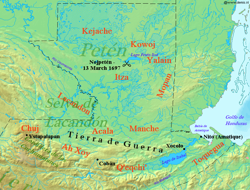
The Lakandon Chʼol were a former Chʼol-speaking Maya people inhabiting the Lacandon Jungle in what is now Chiapas in Mexico and the bordering regions of northwestern Guatemala, along the tributaries of the upper Usumacinta River and the foothills of the Sierra de los Cuchumatanes. The Lakandon Chʼol at contact with the Spanish The Lakandon Chʼol of the time of the Spanish conquest should not be confused with the modern Yucatec-speaking Lacandon people occupying the same region. At the time of Spanish contact in the 16th century, the Lacandon Jungle was inhabited by Chʼol people referred to as ''Lakam Tun''. This name was hispanicised, first to ''El Acantun'', then to ''Lacantun'' and finally to ''Lacandon''. The main Lakandon village was situated on an island in Lake Miramar, also referred to as Lakam Tun by the inhabitants. The Lakandons, together with their equally unconquered Itza enemies to the northeast, had an especially warlike reputation among the Spanish. Later histo ... [...More Info...] [...Related Items...] OR: [Wikipedia] [Google] [Baidu] |
Manche Chʼol
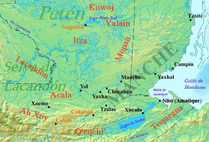
The Manche Chʼol were a former Chʼol-speaking Maya people inhabiting the extreme south of what is now the Petén Department of modern Guatemala, the area around Lake Izabal (also known as the ''Golfo Dulce''), and southern Belize. The Manche Chʼol took the name ''Manche'' from the name of their main settlement. They were the last group of eastern Cholan-speakers to remain independent and ethnically distinct. It is likely that they were descended from the inhabitants of Classic period (c. 250-900 AD) Maya cities in the southeastern Maya region, such as Nim Li Punit, Copán and Quiriguá. The first Spanish contact with the Manche Chʼol was in 1525, when an expedition led by Hernán Cortés crossed their territory. From the early 17th century onwards, Dominican friars attempted to concentrate the Manche into mission towns and convert them to Christianity. These attempts alarmed their warlike Itza neighbours to the northwest, who attacked the mission towns and fomented rebe ... [...More Info...] [...Related Items...] OR: [Wikipedia] [Google] [Baidu] |
Spanish Conquest Of Guatemala
In a protracted conflict during the Spanish colonization of the Americas, Spanish colonisers gradually incorporated the territory that became the modern country of Guatemala into the colonial Viceroyalty of New Spain. Before the conquest, this territory contained a number of competing Mesoamerican kingdoms, the majority of which were Maya. Many conquistadors viewed the Maya as "infidels" who needed to be forcefully converted and pacified, disregarding the achievements of their civilization.Jones 2000, p. 356. The first contact between the Maya and European explorers came in the early 16th century when a Spanish ship sailing from Panama to Santo Domingo was wrecked on the east coast of the Yucatán Peninsula in 1511. Several Spanish expeditions followed in 1517 and 1519, making landfall on various parts of the Yucatán coast. The Spanish conquest of the Maya was a prolonged affair; the Maya kingdoms resisted integration into the Spanish Empire with such tenacity that their d ... [...More Info...] [...Related Items...] OR: [Wikipedia] [Google] [Baidu] |
Acala Chʼol
The Acala Chʼol were a former Chʼol-speaking Maya people who occupied a territory to the west of the Manche Chʼol and east of the Chixoy River in what is now the Alta Verapaz Department of Guatemala. The Acala should not be confused with the people of the former Maya territory of Acalan, near the Laguna de Terminos in Mexico. By the 17th century the Acala had two principal towns; Cagbalam had 300 multiple-family houses and Culhuacan had over 140. The towns were divided into four sections, each governed by their own ruler. The combined population of these two towns has been estimated at 7,000. The Acala were allies of the Lakandon Chʼol, their immediate neighbours to the west, and the two peoples sometimes cooperated militarily. The Acala are known to have cultivated cacao and achiote. In 1555 the Spanish carried out a military expedition against the Acala in retaliation for their killing of Dominican friar Domingo de Vico and his companion Andrés López. The Spanish a ... [...More Info...] [...Related Items...] OR: [Wikipedia] [Google] [Baidu] |
Lacandon People
The Lacandon are one of the Maya peoples who live in the Jungle (terrain), jungles of the Mexican state of Chiapas, near the southern border with Guatemala. Their homeland, the Lacandon Jungle, lies along the Mexican side of the Usumacinta River and its tributaries. The Lacandon are one of the most isolated and culturally conservative of Indigenous peoples of Mexico, Mexico's native peoples. Almost extinct in 1943, today their population has grown significantly, yet remains small, at approximately 650 speakers of the Lacandon language. Culture The Lacandon escaped Conquistador, Spanish control throughout the colonial era by living in small, remote farming communities in the jungles of what is now Chiapas and the Guatemalan department of Petén (department), El Petén, avoiding contact with whites and Ladino people, Ladinos. Lacandon customs remain close to those of their pre-Columbian Mesoamerican ancestors. As recently as the late 19th century some bound the heads of infants, ... [...More Info...] [...Related Items...] OR: [Wikipedia] [Google] [Baidu] |
Ejido
An ''ejido'' (, from Latin ''exitum'') is an area of communal land used for agriculture in which community members have usufruct rights rather than ownership rights to land, which in Mexico is held by the Mexican state. People awarded ejidos in the modern era farm them individually in parcels and collectively maintain communal holdings with government oversight. Although the system of ''ejidos'' was based on an understanding of the preconquest Aztec calpulli and the medieval Spanish ejido, in the twentieth century ejidos are government-controlled. After the Mexican Revolution, ''ejidos'' were created by the Mexican state to grant lands to peasant communities as a means to stem social unrest. As Mexico prepared to enter the North American Free Trade Agreement in 1991, President Carlos Salinas de Gortari declared the end of awarding ejidos and allowed existing ejidos to be rented or sold, ending land reform in Mexico. Colonial-era indigenous community land holdings In cent ... [...More Info...] [...Related Items...] OR: [Wikipedia] [Google] [Baidu] |
Encomiendas
The ''encomienda'' () was a Spanish labour system that rewarded conquerors with the labour of conquered non-Christian peoples. The labourers, in theory, were provided with benefits by the conquerors for whom they laboured, including military protection and education. The ''encomienda'' was first established in Spain following the Christian conquest of Moorish territories (known to Christians as the ''Reconquista''), and it was applied on a much larger scale during the Spanish colonization of the Americas and the Spanish Philippines. Conquered peoples were considered vassals of the Spanish monarch. The Crown awarded an ''encomienda'' as a grant to a particular individual. In the conquest era of the early sixteenth century, the grants were considered to be a monopoly on the labour of particular groups of indigenous peoples, held in perpetuity by the grant holder, called the ''encomendero''; following the New Laws of 1542, upon the death of the ''encomendero'', the encomienda en ... [...More Info...] [...Related Items...] OR: [Wikipedia] [Google] [Baidu] |
Reducciones
Reductions ( es, reducciones, also called ; , pl. ) were settlements created by Spanish rulers and Roman Catholic missionaries in Spanish America and the Spanish East Indies (the Philippines). In Portuguese-speaking Latin America, such reductions were also called ''aldeias''. The Spanish and Portuguese relocated, forcibly in many cases, indigenous inhabitants (''Indians'' or ''Indios'') of their colonies into urban settlements modeled on those in Spain and Portugal. The word "reduction" can be understood wrongly as meaning "to reduce." Rather, the 1611 Spanish dictionary by Sebastián de Covarrubias defines ''reducción'' (reduction) as "to convince, persuade, or to order." The goals of reductions were to concentrate indigenous people into settled communities and to convert the Indians to Christianity and impose European culture. The concentration of the indigenous into towns facilitated the organization and exploitation of their labor. Reductions could be either religio ... [...More Info...] [...Related Items...] OR: [Wikipedia] [Google] [Baidu] |
Lacandon Jungle
The Lacandon Jungle (Spanish: ''Selva Lacandona'') is an area of rainforest which stretches from Chiapas, Mexico, into Guatemala. The heart of this rainforest is located in the Montes Azules Biosphere Reserve in Chiapas near the border with Guatemala in the Montañas del Oriente region of the state. Although much of the jungle outside the reserve has been cleared, the Lacandon is still one of the largest montane rainforests in Mexico. It contains 1,500 tree species, 33% of all Mexican bird species, 25% of all Mexican animal species, 56% of all Mexican diurnal butterflies and 16% of all Mexico's fish species. The Lacandon in Chiapas is also home to a number of important Mayan archaeological sites including Palenque, Yaxchilan and Bonampak, with numerous smaller sites which remain partially or fully unexcavated. This rainforest, especially the area inside the Biosphere Reserve, is a source of political tension, pitting the EZLN or Zapatistas and their indigenous allies who want ... [...More Info...] [...Related Items...] OR: [Wikipedia] [Google] [Baidu] |
Maya Civilization
The Maya civilization () of the Mesoamerican people is known by its ancient temples and glyphs. Its Maya script is the most sophisticated and highly developed writing system in the pre-Columbian Americas. It is also noted for its art, architecture, mathematics, calendar, and astronomical system. The Maya civilization developed in the Maya Region, an area that today comprises southeastern Mexico, all of Guatemala and Belize, and the western portions of Honduras and El Salvador. It includes the northern lowlands of the Yucatán Peninsula and the highlands of the Sierra Madre, the Mexican state of Chiapas, southern Guatemala, El Salvador, and the southern lowlands of the Pacific littoral plain. Today, their descendants, known collectively as the Maya, number well over 6 million individuals, speak more than twenty-eight surviving Mayan languages, and reside in nearly the same area as their ancestors. The Archaic period, before 2000 BC, saw the first developments in a ... [...More Info...] [...Related Items...] OR: [Wikipedia] [Google] [Baidu] |


_(5618095756).jpg)


