|
Chirnside
Chirnside is a hillside village in Berwickshire, Scotland, west of Berwick-upon-Tweed and east of Duns. Church The parish church at Chirnside dates from the 12th century. It was substantially rebuilt in 1878 and extensively restored and altered in 1907. The rebuildings now incorporate all of the original church(es), however the original chevron-patterned Norman doorway at the west end remains. Dovecot aviaries The ''Ninewells Doocot'', in a garden adjacent to the church, is a 16th-century circular beehive type doocot (dovecot). Not far from the manor, stands the ''Whitehall Doocot'', rectangular-planned, and two-chamber, with stone skews defining its mono-pitched roof. Whitehall Below Chirnside stands the estate of Whitehall, with a Georgian manor house containing Palladian windows, which is a Listed Building. It contains a first floor music room richly decorated in Italian plasterwork. Once owned by the Hall of Dunglass family, William Hall of Whitehall (die ... [...More Info...] [...Related Items...] OR: [Wikipedia] [Google] [Baidu] |
Chirnside Parish Church
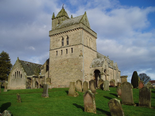
Chirnside Parish Church is a kirk of the Church of Scotland. It is situated on the B6355 road between Duns and Eyemouth in the old county of Berwickshire, now part of the Scottish Borders, at . The town of Chirnside is east of Duns, and north-west of Berwick-upon-Tweed. History The first records of Chirnside and its church came in the early 12th century during the reign of King Edgar of Scotland (1097–1107), in a charter granting the lands and church to the monks of Durham. The 12th-century church was known as ''Ecclesia de Chirnyside'' and it was valued at 50 merks. The first church at Chirnside was a plain rectangular building with a thatched roof and earthen floor. The altar dominated the east end and a priest would conduct daily mass, probably from a pulpit near the altar. The ''Ecclesia de Chirnyside'' was dedicated, like many other church establishments in the area, by David de Bernham, Bishop of St Andrews, on 13 April 1242. In 1524 a young man named Luke Aches ... [...More Info...] [...Related Items...] OR: [Wikipedia] [Google] [Baidu] |
Berwickshire Railway
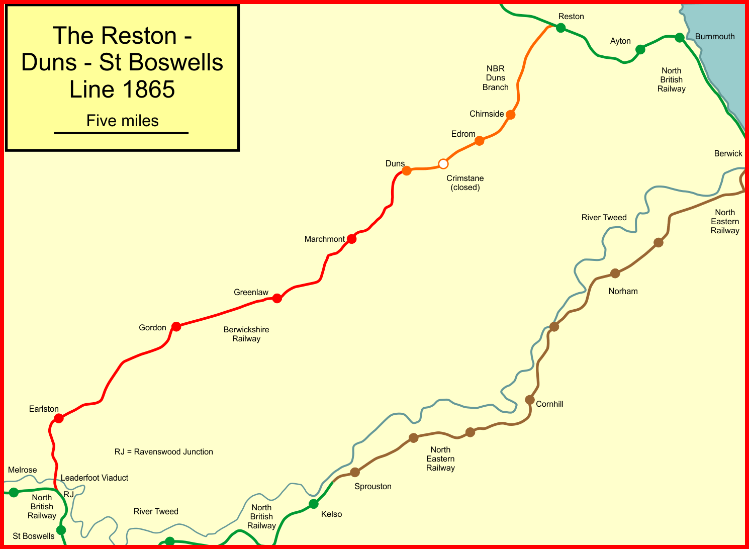
The Duns Branch and the Berwickshire Railway together formed a through railway route from Reston, Scottish Borders, Reston, near Berwick-upon-Tweed, to St Boswells in the Scottish Borders. The line was promoted in two stages. The first was from Reston on the Edinburgh to Berwick main line to Duns, Scottish Borders, Duns (then spelt ''Dunse'', and the county town of Berwickshire); it opened by the North British Railway in 1849. The second section was promoted independently by the Berwickshire Railway Company, but with considerable assistance from the North British Railway. It opened most of its line in 1863, but delay in constructing a large viaduct, Leaderfoot Viaduct, led to the opening of the final section of the line being delayed until 1865. The North British Railway had conceived the line as a strategic trunk route across southern Scotland, but this development was never realised, and the line was never heavily used. During the violent rainstorm in the area in August 1948 ... [...More Info...] [...Related Items...] OR: [Wikipedia] [Google] [Baidu] |
David Hume
David Hume (; born David Home; 7 May 1711 NS (26 April 1711 OS) – 25 August 1776) Cranston, Maurice, and Thomas Edmund Jessop. 2020 999br>David Hume" ''Encyclopædia Britannica''. Retrieved 18 May 2020. was a Scottish Enlightenment philosopher, historian, economist, librarian, and essayist, who is best known today for his highly influential system of philosophical empiricism, scepticism, and naturalism. Beginning with '' A Treatise of Human Nature'' (1739–40), Hume strove to create a naturalistic science of man that examined the psychological basis of human nature. Hume argued against the existence of innate ideas, positing that all human knowledge derives solely from experience. This places him with Francis Bacon, Thomas Hobbes, John Locke, and George Berkeley as an Empiricist. Hume argued that inductive reasoning and belief in causality cannot be justified rationally; instead, they result from custom and mental habit. We never actually perceive that one event caus ... [...More Info...] [...Related Items...] OR: [Wikipedia] [Google] [Baidu] |
Ayton Castle, Scottish Borders
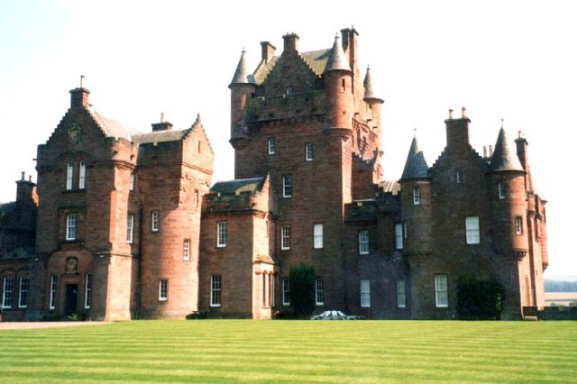
Ayton Castle is located to the east of Ayton in the Scottish Borders. It is north-west of Berwick-upon-Tweed, in the former county of Berwickshire. Built around a medieval tower house, the present castle dates largely from the 19th century. Ayton Castle is the ''caput'' of the feudal barony of Ayton. The castle is protected as a category A listed building, and the grounds are included in the Inventory of Gardens and Designed Landscapes in Scotland, the national listing of significant parks and gardens. History The original castle, a peel tower, had once been a stronghold of the Home family. This castle was captured by the English in 1497, and the nearby church was the scene of the subsequent negotiation of the treaty of Ayton, signed on 30 September 1497. The tower was replaced by a classical mansion, which burnt down in 1834. The estate was subsequently purchased by William Mitchell (later Mitchell-Innes) of Parsonsgreen, Edinburgh, who had been born at Belhelvie, Aberde ... [...More Info...] [...Related Items...] OR: [Wikipedia] [Google] [Baidu] |
Berwickshire
Berwickshire ( gd, Siorrachd Bhearaig) is a historic county, registration county and lieutenancy area in south-eastern Scotland, on the English border. Berwickshire County Council existed from 1890 until 1975, when the area became part of the Borders region, with most of the historic county becoming part of the lower-tier Berwickshire district. Berwickshire district was abolished in 1996, when all the districts in the Borders region merged to become the Scottish Borders council area. The county takes its name from Berwick-upon-Tweed, its original county town, which was part of Scotland at the time of the county's formation in the twelfth century, but became part of England in 1482 after several centuries of swapping back and forth between the two kingdoms. After the loss of Berwick, Duns and Greenlaw both served as county town at different periods. The low-lying part of Berwickshire between the Tweed and the Lammermuirs is known as "the Merse", from an old Scots word for a ... [...More Info...] [...Related Items...] OR: [Wikipedia] [Google] [Baidu] |
Duns, Scottish Borders
Duns is a town in the Scottish Borders, Scotland. It was the county town of the Shires of Scotland, historic county of Berwickshire. History Early history Duns Law, the original site of the town of Duns, has the remains of an Iron Age hillfort at its summit. Similar structures nearby, such as the structure at Edin's Hall Broch, suggest the area's domestic and defensive use at a very early stage. Middle ages The first written mention of Duns is prior to 1179, when a 'Hugo de Duns' witnessed a charter of Roger d'Eu, of a grant of the benefice of the church of Gavinton, Berwickshire, Langton to Kelso Abbey. The town is further mentioned when a 'Robert of Douns' signed the Ragman Roll in 1296. The early settlement was sited on the slopes of Duns Law, close to the original Duns Castle built in 1320 by the Thomas Randolph, 1st Earl of Moray, Earl of Moray, nephew of Robert the Bruce. The town was frequently attacked by the English in border raids and as they headed north to the Loth ... [...More Info...] [...Related Items...] OR: [Wikipedia] [Google] [Baidu] |
Whiteadder Water
Whiteadder Water is a river in East Lothian and Berwickshire, Scotland. It also flows for a very short distance through Northumberland before joining the River Tweed. In common with the headwaters of the Biel Water it rises on the low hillside of Clints Dod () in the Lammermuir Hills, just ESE of Whitecastle Hillfort and south-east of the village of Garvald. Etymology ''Adder'' may be derived from Brittonic ''*ador, *edir'' or Old English ''edre'', possible ancient hydronymic terms derived from an Indo-European formation meaning "a watercourse, a channel" (compare River Etherow). The possibility of the name deriving from Old English ''ǣdre'', "a vein" ( Anglian ''ēdre''), or ''*ǣdre'', meaning "quickly" is objected on the grounds that these would have maintained the long initial vowel in English and Scots. Also suggested is derivation from Gaelic ''fad dûr'', meaning "long water". though the Gaelic was never spoked in the Scottish southeast. Course The stream wends i ... [...More Info...] [...Related Items...] OR: [Wikipedia] [Google] [Baidu] |
Blanerne Castle
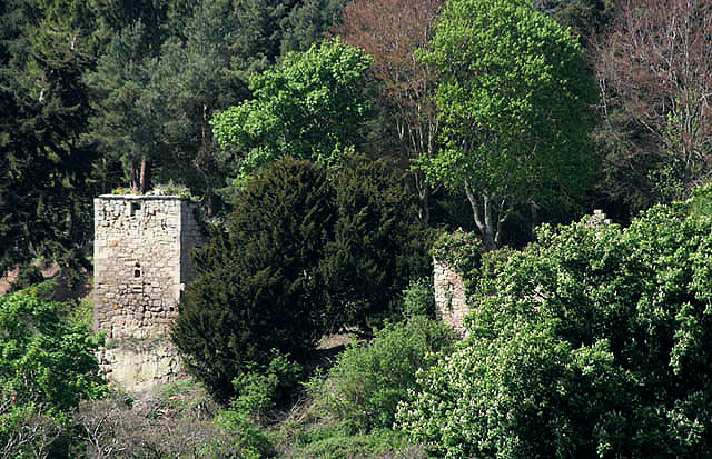
Blanerne Castle is the remains of a 16th-century fortified house, located in the grounds of Blanerne House, an 18th-century country house between Chirnside and Preston in the Scottish Borders. The house and castle sit on the north bank of the Whiteadder Water, around north-east of Duns. The castle was the historical seat of the Lumsdaine family for over four centuries. The surviving remains are dated to the 16th century, although the site may have been occupied as far back as the 12th century. The remains include a keep or kitchen block, with a detached guard house to the west. The castle is protected as a Scheduled Ancient Monument. A popular Berwickshire rhyme refers to the medieval strengths of Blanerne and the nearby fortresses of Billie Castle, and Bonkyll Castle referring to their construction in the time of David I and their destruction following the Rough wooing: ''Bunkle, Billie and Blanerne ''Three castles strong as airn'' ''Built when Davie was a Bairn'' ''Theyll ... [...More Info...] [...Related Items...] OR: [Wikipedia] [Google] [Baidu] |
Billie Castle
Billie Castle is a ruined 15th century quadrangular castle, north west of Chirnside, Scottish Borders, Scotland, north of Billiemains.Coventry, Martin (1997) ''The Castles of Scotland''. Goblinshead. p. 78 It was designated as a scheduled monument in 1988. History The property was owned by the Dunbars. Archibald Douglas, 6th Earl of Angus sheltered here in 1528 whilst his castle of Tantallon was being unsuccessfully besieged by James V of Scotland, the Angus family having acquired it in 1435. The Renton family were granted the castle in 1540, after it had been annexed by the Crown, but it was slighted by the forces of the Earl of Hertford in May 1544 after they had burnt Edinburgh. The castle was held against the English again, and in February 1548 Hugh Willoughby was sent with Thomas Carlisle and 50 horsemen by Grey of Wilton to captured "Billie tower". 10 men dismounted and took the "barbican" from a guard of four Scots. James VI of Scotland alarmed the English garrison ... [...More Info...] [...Related Items...] OR: [Wikipedia] [Google] [Baidu] |
Scottish Borders
The Scottish Borders ( sco, the Mairches, 'the Marches'; gd, Crìochan na h-Alba) is one of 32 council areas of Scotland. It borders the City of Edinburgh, Dumfries and Galloway, East Lothian, Midlothian, South Lanarkshire, West Lothian and, to the south-west, south and east, the English counties of Cumbria and Northumberland. The administrative centre of the area is Newtown St Boswells. The term Scottish Borders, or normally just "the Borders", is also used to designate the areas of southern Scotland and northern England that bound the Anglo-Scottish border. Geography The Scottish Borders are in the eastern part of the Southern Uplands. The region is hilly and largely rural, with the River Tweed flowing west to east through it. The highest hill in the region is Broad Law in the Manor Hills. In the east of the region, the area that borders the River Tweed is flat and is known as 'The Merse'. The Tweed and its tributaries drain the entire region with the river flowi ... [...More Info...] [...Related Items...] OR: [Wikipedia] [Google] [Baidu] |


