|
Chee Dale
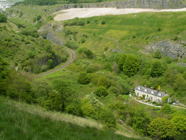
Chee Dale is a steep-sided gorge on the River Wye near Buxton, Derbyshire, in the Peak District of England. Wye Dale continues upstream towards Buxton while downstream are Miller's Dale village and valley. Chee Dale has a protected nature reserve (close to the village of Wormhill), which is overseen by the Derbyshire Wildlife Trust. The reserve contains ash, yew and rock whitebeam woodland on the cliff sides and abundant wild flowers including cowslips, early purple orchids, rock rose and the rare Jacob's ladder. Dippers are often seen darting low above the river and bobbing on rocks in the river. Other birds nesting in the valley include blackcap, chiffchaff and willow warbler. Chee Dale is part of the Wye Valley Site of Special Scientific Interest (SSSI), running for east of Buxton. The Monsal Trail bridleway runs for from Topley Pike Junction (at the head of Chee Dale) to Rowsley near Bakewell, along the disused Manchester, Buxton, Matlock and Midlands Junction Railwa ... [...More Info...] [...Related Items...] OR: [Wikipedia] [Google] [Baidu] |
River Wye, Derbyshire
The River Wye is a limestone river in the Peak District of Derbyshire, England. It is 22 miles long (widely but incorrectly attributed as 15 miles/24 km, which refers to the section within the National Park), and is one of the major tributaries of the River Derwent, which flows into the River Trent, and ultimately into the Humber and the North Sea. The river rises just west of Buxton, on Axe Edge Moor. Part of the flow passes underground through Poole's Cavern before rising at Wye Head, and flowing through the Pavilion Gardens in Buxton. It then flows east through the dales of the Wye Valley, along a route roughly followed by the A6 road. It enters the Peak District, flows just south of Tideswell, then through Ashford in the Water and Bakewell, and south of Haddon Hall, before meeting the River Derwent at Rowsley. The main tributary of the river is the River Lathkill, which enters approximately one mile from its mouth. The River Wye is one of Derbyshire's best-known ... [...More Info...] [...Related Items...] OR: [Wikipedia] [Google] [Baidu] |
Polemonium Caeruleum
''Polemonium caeruleum'', known as Jacob's-ladder or Greek valerian, is a hardy perennial flowering plant. The plant produces cup-shaped, blue or white flowers. It is native to temperate regions of Europe. Growth The plant usually reaches tall and broad, but some occasionally grow taller than . It can grow in North American hardiness zone 2. Habitat The plant is native to damp grasslands, woodlands, meadows and rocky areas in temperate areas of Europe and Asia. Cultivation The plant normally prefers soil that is rich in moisture and lime with partial shade. Normally hardy, some cultivars (e.g. 'Blue Pearl') behave as tender biennials, which means they are effectively annuals in cooler climates (below hardiness zone 6). The plant is known to have a few landscape uses as well such as attracting beneficial insects. The plant itself is convenient for container planting due to the shape of its growth. The flower may be presented as a cut flower or foliage and may be added to bou ... [...More Info...] [...Related Items...] OR: [Wikipedia] [Google] [Baidu] |
Blackwell Mill
Blackwell Mill is a location in Derbyshire, near to the village of Blackwell near Buxton, but not part of it. There was once a corn mill on the River Wye which may have dated from 1066. Most of it has disappeared, apart from the weir. What is left is marked as an Ancient Monument. It stands at the meeting point of several valleys: Great Rocks Dale, Chee Dale and Ashford Dale. In times past the Manchester Turnpike forded the river. It marks the northern end of the public path from Bakewell, used by walkers and cyclists, called the Monsal Trail. The trail follows the trackbed of the former Midland Railway main line from London to Manchester. Blackwell Mill lies between Bakewell and Buxton, on the Midland's attempt to extend the Manchester, Buxton, Matlock and Midlands Junction Railway into Manchester. This point was the south curve of the triangular junction which it built when it, instead, extended to New Mills. There was a railway station variously called "Blackwell Mill" ... [...More Info...] [...Related Items...] OR: [Wikipedia] [Google] [Baidu] |
Great Rocks Dale
Great Rocks Dale is a dry valley in the Derbyshire Peak District, known for its extensive quarrying. Geography and geology The valley runs from Peak Dale down to Blackwell Mill at Chee Dale on the River Wye. The scenery is of limestone, which extends to a depth of around 380 metres. It contains the only dikes in the White Peak. Boreholes have enabled the extraction of significant amounts of water, used by local industry. Prior to the local quarrying, the southern part of the valley was described as "narrow, flat-bottomed, rocky... ithalmost perpendicular cliffs of limestone on either side...", whereas the northern part was broader and grassy. History The dale fell within the bounds of the mediaeval Forest of High Peak. The surrounding land was first farmed in about 1250, by people connected with the nearby hamlet of Tunstead. In 1867, an extension of the Manchester, Buxton, Matlock and Midlands Junction Railway was opened, running through the valley between Peak Forest ... [...More Info...] [...Related Items...] OR: [Wikipedia] [Google] [Baidu] |
Chee Tor Limestone
The Chee Tor Limestone is a geologic formation in England. It preserves fossils dating back to the Carboniferous period. See also * List of fossiliferous stratigraphic units in England See also *Lists of fossiliferous stratigraphic units in Europe * Lists of fossiliferous stratigraphic units in the United Kingdom References * {{DEFAULTSORT:Fossiliferous stratigraphic units in England England England is a country ... References * Carboniferous System of Europe Carboniferous England Limestone formations Carboniferous southern paleotropical deposits {{England-stub ... [...More Info...] [...Related Items...] OR: [Wikipedia] [Google] [Baidu] |
Manchester, Buxton, Matlock And Midlands Junction Railway
The Manchester, Buxton, Matlock and Midland Junction Railway ran from a junction with the Midland Railway at Ambergate to Rowsley north of Matlock and thence to Buxton. In time it would become part of the Midland Railway's main line between London and Manchester, but it was initially planned as a route from Manchester to the East of England, via the proposed Ambergate, Nottingham, Boston and Eastern Junction Railway which would meet it a little further north along the North Midland line at Ambergate. The Act for a line from just south of Stockport to Ambergate was passed in 1846. Currently, the section north of Millers Dale is open as the Great Rocks freight line, Derby to Matlock still holds passenger services as the Derwent Valley line, Matlock to Rowsley is the Peak Rail heritage line, and Rowsley to Buxton has become the Monsal Trail for cycling, horse riding and walking. Ambergate to Rowsley The initial plan was for "An Act for making a Railway from the Manchester an ... [...More Info...] [...Related Items...] OR: [Wikipedia] [Google] [Baidu] |
Bakewell
Bakewell is a market town and civil parish in the Derbyshire Dales district of Derbyshire, England, known also for its local Bakewell pudding. It lies on the River Wye, about 13 miles (21 km) south-west of Sheffield. In the 2011 census, the population of the civil parish appeared as 3,949. It was estimated at 3,695 in 2019. The town is close to the tourist attractions of Chatsworth House and Haddon Hall. History Although there is evidence of earlier settlement in the area, Bakewell itself was probably founded in Anglo-Saxon times in the Anglian kingdom of Mercia. The name Bakewell means a spring or stream of a woman named Badeca or Beadeca, so deriving from a personal name with the Old English suffix ''wella''. In 949 it was called Badecanwelle and in the 1086 Domesday Book ''Badequelle''. The Domesday book listing stated that King Edward held land here; the settlement had a church and a mill. These are the outlying estates or berewicks of the manor: Haddon addon or Ov ... [...More Info...] [...Related Items...] OR: [Wikipedia] [Google] [Baidu] |
Rowsley
Rowsley () is a village on the A6 road in the English county of Derbyshire. The population as at the 2011 census was 507. It is at the point where the River Wye flows into the River Derwent and prospered from mills on both. The border of the Peak District National Park runs through the village west of the River Wye and immediately to the north of Chatsworth Road. The Peak District Boundary Walk goes through the village. Overview Notable features are the bridge over the River Derwent, St Katherine's Church, Rowsley and the Grade-II*-listed Peacock hotel, originally built in 1652 as a manor house by John Stevenson, agent to Lady Manners, whose family crest bearing a peacock gives it its name. Both Longfellow and Landseer are said to have stayed there. Nearby is Chatsworth House, home of the Duke and Duchess of Devonshire. It was the site of an extensive motive power depot and marshalling yard, the first being built by the Manchester, Buxton, Matlock and Midlands Junction Rail ... [...More Info...] [...Related Items...] OR: [Wikipedia] [Google] [Baidu] |
Monsal Trail
The Monsal Trail is a cycling, horse riding and walking trail in the Derbyshire Peak District. It was constructed from a section of the former Manchester, Buxton, Matlock and Midland Junction Railway, which was built by the Midland Railway in 1863 to link Manchester with London and closed in 1968. The Monsal Trail is about long and opened in 1981. It starts at the Topley Pike junction in Wye Dale, east of Buxton, and runs to Coombs Viaduct, south-east of Bakewell. It follows the valley of the River Wye. The trail passes through Blackwell Mill, Chee Dale, Millers Dale, Cressbrook, Monsal Dale, Great Longstone, Hassop and Bakewell. The trail has numerous landmarks including Headstone Viaduct, Cressbrook Mill, Litton Mill and Hassop railway station, and passes through six tunnels. It is a major part of the as yet incomplete White Peak Loop and is designated as National Cycle Route 680. History The Monsall Trail follows a section of the former Manchester, Buxton, Matlock and ... [...More Info...] [...Related Items...] OR: [Wikipedia] [Google] [Baidu] |
Chee Tor Tunnel - Geograph
{{disambig ...
Chee may refer to: People * Chee (given name), a unisex given name * Chee (surname), a surname Other uses * 22158 Chee, a main-belt asteroid * Chée, a river in northeastern France * Chee, a race of androids in the ''Animorphs'' novel series See also * Chi (other) * Qi (other) * Chee-Chee (other) Chee-Chee or Chee Chee may refer to: *Chee-Chee, a monkey character in the Doctor Dolittle series of children's books * Chee-Chee, an ethnic slur against an Anglo-Indian or Eurasian half-caste; also a reference to English spoken with a South Asian ... [...More Info...] [...Related Items...] OR: [Wikipedia] [Google] [Baidu] |
Site Of Special Scientific Interest
A Site of Special Scientific Interest (SSSI) in Great Britain or an Area of Special Scientific Interest (ASSI) in the Isle of Man and Northern Ireland is a conservation designation denoting a protected area in the United Kingdom and Isle of Man. SSSI/ASSIs are the basic building block of site-based nature conservation legislation and most other legal nature/geological conservation designations in the United Kingdom are based upon them, including national nature reserves, Ramsar sites, Special Protection Areas, and Special Areas of Conservation. The acronym "SSSI" is often pronounced "triple-S I". Selection and conservation Sites notified for their biological interest are known as Biological SSSIs (or ASSIs), and those notified for geological or physiographic interest are Geological SSSIs (or ASSIs). Sites may be divided into management units, with some areas including units that are noted for both biological and geological interest. Biological Biological SSSI/ASSIs may ... [...More Info...] [...Related Items...] OR: [Wikipedia] [Google] [Baidu] |
Willow Warbler
The willow warbler (''Phylloscopus trochilus'') is a very common and widespread leaf warbler which breeds throughout northern and temperate Europe and the Palearctic, from Ireland east to the Anadyr River basin in eastern Siberia. It is strongly migratory, with almost all of the population wintering in sub-Saharan Africa. It is a bird of open woodlands with trees and ground cover for nesting, including most importantly birch, alder, and willow habitats. The nest is usually built in close contact with the ground, often in low vegetation. Like most Old World warblers (Sylviidae), this small passerine is insectivorous. In northern Europe, it is one of the first warblers to return in the spring, though later than the closely related chiffchaff. Taxonomy The willow warbler was formally described by the Swedish naturalist Carl Linnaeus in 1758 in the tenth edition of his ''Systema Naturae'' under the binomial name ''Motacilla trochilus''. The willow warbler is now one of around 8 ... [...More Info...] [...Related Items...] OR: [Wikipedia] [Google] [Baidu] |


