|
Checkerboard Hill
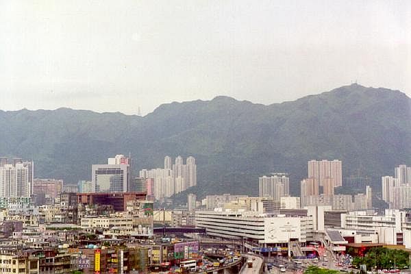
Checkerboard Hill (), also known as Kowloon Tsai Hill () and Tak Mee Mountain (), is a small hill in the northern part of the Kowloon peninsula in Hong Kong. Standing at tall, Checkerboard Hill is located next to Kowloon Tsai Park and the Lok Fu Service Reservoir Rest Garden () of Lok Fu Park (), and it is not far from Lion Rock Country Park. Name The hill's name dates back to the time when airline pilots had to navigate towards this hill in order to land on Runway 13 of the now-closed Kai Tak Airport. Pilots would set their onboard navigation systems to fly the Instrument Guidance System (IGS) path straight towards a large red and white checkerboard on the side of the hill, then once the checkerboard pattern was sighted and identified, they would make a low-altitude right-hand turn to align visually with Runway 13. Kai Tak Airport was demanding for pilots, and it required special training, since the approach to runway 13 could not be flown entirely by instrument, but require ... [...More Info...] [...Related Items...] OR: [Wikipedia] [Google] [Baidu] |
Kowloon Peninsula
The Kowloon Peninsula is a peninsula that forms the southern part of the main landmass in the territory of Hong Kong, alongside Victoria Harbour and facing toward Hong Kong Island. The Kowloon Peninsula and the area of New Kowloon are collectively known as Kowloon. Geographically, the term "Kowloon Peninsula" may also refer to the area south of the mountain ranges of Beacon Hill, Lion Rock, Tate's Cairn, Kowloon Peak, etc. The peninsula covers five of the eighteen districts of Hong Kong. Kowloon Bay is located at the northeast of the peninsula. Geology and reclamation The main rock type of the peninsula consists of a medium grained monzogranite with some fine granite outcrops, part of the Kowloon Granite. Early maps and photographs show flat, low-lying land behind the beach of Tsim Sha Tsui Bay with a raised area, Kowloon Hill, in the west. The peninsula has been significantly expanded through land reclamation from the sea, over several phases. In the south and west most o ... [...More Info...] [...Related Items...] OR: [Wikipedia] [Google] [Baidu] |
Kowloon Tsai Park
Kowloon Tsai Park is a park located in the Kowloon Tsai area of New Kowloon in Hong Kong. It lies within the Kowloon City District and opened on 5 June 1964. History In the 1950s, the area was used as a borrow area to supply fill for the extension of the nearby Kai Tak Airport runway. The Urban Council commissioned architecture firm Leigh and Orange to draw up plans for the redevelopment of this area of "barren hills and waste lands" as a new recreational area for the citizens of Kowloon. The first phase of the new park opened in 1964. The Kowloon Tsai Swimming Pool, the first in Kowloon, was funded by the Royal Hong Kong Jockey Club and also opened in 1964. Originally, the pool was not open in the evening because it sat under the airport flight path, hence the Civil Aviation Department would not agree on the use of outdoor floodlighting there. Features The park consists of three football fields (2 artificial grass and 1 natural grass), two basketball courts, two 7-a-side footb ... [...More Info...] [...Related Items...] OR: [Wikipedia] [Google] [Baidu] |
Lion Rock Country Park
Lion Rock Country Park (established 24 June 1977) is a country park, located in the New Territories, Hong Kong. It consists of approximately of land, including Lion Rock and Mong Fu Shek (Amah Rock) and their surrounding scenic hillsides, of which is forestry plantation. Landmarks The dominant topographical feature of the park is the Lion Rock, which from some angles resembles a lion perching on a hill ridge. Another topographical feature of the park is the Mong Fu Shek (Amah Rock). The legend is that of a faithful wife who climbed the hills every day, carrying her son, to watch for the return of her husband, not knowing he had been drowned at sea. In reward for her faithfulness she was turned into a rock by the Goddess of the Sea so that her spirit could unite with that of her husband. Beacon Hill is another landscape feature of the park. Its Chinese name derives from the warning fire signals which were lit during the Qing dynasty on the hill top, which was one of the many " ... [...More Info...] [...Related Items...] OR: [Wikipedia] [Google] [Baidu] |
Kai Tak Airport
Kai Tak Airport was the international airport of Hong Kong from 1925 until 1998. Officially known as Hong Kong International Airport from 1954 to 6 July 1998, it is often referred to as Hong Kong International Airport, Kai Tak, or simply Kai Tak and Kai Tak International Airport, to distinguish it from its successor, Chek Lap Kok International Airport, built on reclaimed and levelled land around the islands of Chek Lap Kok and Lam Chau, to the west. Because of the geography of the area positioning the airport with water on three sides of the runway, with Kowloon City's residential apartment complexes and 2000-plus foot mountains to the north-east of the airport, aircraft could not fly over the mountains and quickly drop in for a final approach. Instead, aircraft had to fly above Victoria Harbour and Kowloon City, passing north of Mong Kok's Bishop Hill. After passing Bishop Hill, pilots would see Checkerboard Hill with a large red and white checkerboard pattern. Once the pa ... [...More Info...] [...Related Items...] OR: [Wikipedia] [Google] [Baidu] |
Instrument Landing System
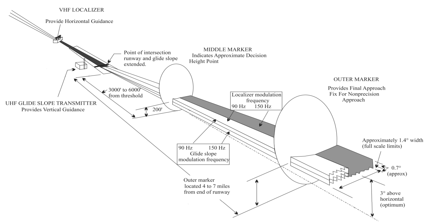
In aviation, the instrument landing system (ILS) is a precision radio navigation system that provides short-range guidance to aircraft to allow them to approach a runway at night or in bad weather. In its original form, it allows an aircraft to approach until it is over the ground, within a of the runway. At that point the runway should be visible to the pilot; if it is not, they perform a missed approach. Bringing the aircraft this close to the runway dramatically increases the range of weather conditions in which a safe landing can be made. Other versions of the system, or "categories", have further reduced the minimum altitudes, runway visual ranges (RVRs), and transmitter and monitoring configurations designed depending on the normal expected weather patterns and airport safety requirements. ILS uses two directional radio signals, the ''localizer'' (108 to 112 MHz frequency), which provides horizontal guidance, and the ''glideslope'' (329.15 to 335 MHz frequency ... [...More Info...] [...Related Items...] OR: [Wikipedia] [Google] [Baidu] |
Hong Kong International Airport
Hong Kong International Airport is Hong Kong's main airport, built on reclaimed land on the island of Chek Lap Kok, Hong Kong. The airport is also referred to as Chek Lap Kok International Airport or ''Chek Lap Kok Airport'', to distinguish it from its predecessor, the former Kai Tak International Airport. Having been in commercial operation since 1998, Hong Kong International Airport is one of the largest trans-shipment centres, passenger hubs and gateways for destinations in greater China, Asia and the world. The airport is the world's busiest cargo gateway and one of the world's busiest passenger airports. It is also home to one of the world's largest passenger terminal buildings (the largest when opened in 1998). The airport is operated by the Airport Authority 24 hours a day and is the primary hub for Cathay Pacific (the flag carrier of Hong Kong), Greater Bay Airlines, Hong Kong Airlines, HK Express and Air Hong Kong (cargo carrier). The airport is one of the hubs ... [...More Info...] [...Related Items...] OR: [Wikipedia] [Google] [Baidu] |
Lantau Island
Lantau Island (also Lantao Island, Lan Tao) is the largest island in Hong Kong, located West of Hong Kong Island and the Kowloon Peninsula, and is part of the New Territories. Administratively, most of Lantau Island is part of the Islands District of Hong Kong. A small northeastern portion of the island is located in the Tsuen Wan District. Originally an island with fishing villages, it has been developed since the late 20th century with the construction of Tung Chung New Town on its north-western coast and the completion of several major infrastructure projects, including Lantau Link (1997), Hong Kong International Airport (1998), Hong Kong Disneyland (2005), Ngong Ping 360 (2006) and Penny's Bay Quarantine Centre (2020). Geography With a land mass of , it is the largest island in Hong Kong, almost twice the size of Hong Kong Island. Lantau Island primarily consists of mountainous terrain. Lantau Peak () is the highest point of the island. It is the second highes ... [...More Info...] [...Related Items...] OR: [Wikipedia] [Google] [Baidu] |
Checkerboard Hill, Hong Kong 2022
A checkerboard (American English) or chequerboard (British English; see spelling differences) is a board of checkered pattern on which checkers (also known as English draughts) is played. Most commonly, it consists of 64 squares (8×8) of alternating dark and light color, typically green and buff (official tournaments), black and red (consumer commercial), or black and white (printed diagrams). An 8×8 checkerboard is used to play many other games, including chess, whereby it is known as a chessboard. Other rectangular square-tiled boards are also often called checkerboards. Games and puzzles using checkerboards Martin Gardner featured puzzles based on checkerboards in his November 1962 Mathematical Games column in Scientific American. A square checkerboard with an alternating pattern is used for games including: * Amazons * Chapayev * Chess and some of its variants (see chessboard) * Czech draughts * Draughts, also known as checkers * Fox games * Frisian draughts * Gounki * In ... [...More Info...] [...Related Items...] OR: [Wikipedia] [Google] [Baidu] |
List Of Mountains, Peaks And Hills In Hong Kong
The following is a list of mountains, peaks and hills in Hong Kong. In the romanisation system used by the Hong Kong Government known as Standard Romanisation, 'shan' and 'leng' are the transliterations of the Cantonese words for 'mount' (山) and 'ridge' (嶺), respectively. 'Toi', 'kong', 'fung' and 'koi' also correspond to 'mount' in English and 'teng' corresponds to 'peak'. It is this system which is used in the list below. Highest peaks of Hong Kong Lesser Hills There are numerous smaller hills that dot Hong Kong and some that have disappeared with re-development: Volcanoes *Tai Mo Shan * High Island Supervolcano * Kwun Yam Shan, Lam Tsuenhttp://geolsoc.org.hk/_newsletters/VOL%252014.2_Mar2008.pdf https://www.facebook.com/permalink.php?id=231062983601269&story_fbid=673694836004746& Removed hills *Cheung Pei Shan *Sacred Hill See also * Geography of Hong Kong * Mountain Search and Rescue Company References External links Peaks in Hong Kong, with heigh ... [...More Info...] [...Related Items...] OR: [Wikipedia] [Google] [Baidu] |


